
Earthquakes Living Lab: Locating Earthquakes
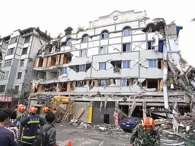 During the 2008 Sichuan earthquake, the second floor of this building collapsed, killing several people and trapping a pregnant woman and an elderly woman.Copyright 2008 miniwiki.org via Wikimedia Commons http://commons.wikimedia.org/wiki/File:Sichuan_earthquake_building_collasped..JPG
Students use U.S. Geological Survey (USGS) real-time, real-world seismic data from around the planet to identify where earthquakes occur and look for trends in earthquake activity. They explore where and why earthquakes occur, learning about faults and how they influence earthquakes. Looking at the interactive maps and the data, students use Microsoft® Excel® to conduct detailed analysis of the most-recent 25 earthquakes; they calculate mean, median, mode of the data set, as well as identify the minimum and maximum magnitudes. Students compare their predictions with the physical data, and look for trends to and patterns in the data. A worksheet serves as a student guide for the activity.
Every year, thousands of people die in earthquakes, and many more homes and communities are destroyed or damaged. Many of these catastrophes can be mitigated, however, by smart engineering. The first step in protection is determining where earthquakes are likely to occur, and how severe they may be. Some techniques engineers use include looking at fault lines, examining previous earthquake data and identifying patterns and trends.
Scientists and engineers around the globe gather data through observation and experimentation and use it to describe and understand how the world works. The Earthquakes Living Lab gives students the chance to track earthquakes across the planet and examine where, why and how they are occurring. Using the real-world data in the living lab enables students and teachers to practice analyzing data to solve problems and answer questions, in much the same way that scientists and engineers do every day.
After this activity, students should be able to:
- Describe what a fault is, and how it can cause earthquakes.
- Use USGS online maps to retrieve data.
- Explain how engineers use earthquake data.
- Analyze and interpret data about natural hazards using direct and indirect evidence
Grades 9-12
Do you agree with this alignment? - Seek, evaluate, and use a variety of specialized resources available from libraries, the Internet, and the community to find scientific information on Earth's history
Grades 9-12
Do you agree with this alignment?
- STEL-4P Evaluate ways that technology can impact individuals, society, and the environment.
Grades 9-12
Do you agree with this alignment? - STEL-4R Assess a technology that minimizes resource use and resulting waste to achieve a goal.
Grades 9-12
Do you agree with this alignment?
- MS-ESS3-2 Analyze and interpret data on natural hazards to forecast future catastrophic events and inform the development of technologies to mitigate their effects.
Grades 6-8
This resource focuses on the following Three Dimensional Learning aspects of NGSS:
Science & Engineering Practices- Construct an oral and written argument supported by empirical evidence and scientific reasoning to support or refute an explanation or a model for a phenomenon or a solution to a problem.Do you agree with this alignment?
Disciplinary Core Ideas- Mapping the history of natural hazards in a region, combined with an understanding of related geologic forces can help forecast the locations and likelihoods of future events.Do you agree with this alignment?
Crosscutting Concepts- The uses of technologies and any limitations on their use are driven by individual or societal needs, desires, and values; by the findings of scientific research; and by differences in such factors as climate, natural resources, and economic conditions. Thus technology use varies from region to region and over time.Do you agree with this alignment?
- Graphs, charts, and images can be used to identify patterns in data.Do you agree with this alignment?
Do you agree with this alignment? - Construct an oral and written argument supported by empirical evidence and scientific reasoning to support or refute an explanation or a model for a phenomenon or a solution to a problem.
Each group needs:
- computer or other device and Internet access
- Microsoft® Excel® (or similar application) to calculate the mean, median and mode
- journal or writing paper for each student
- pen or pencil, one per student
- Where Are Earthquakes Happening Right Now? Worksheet (PDF), one per group
Students should be able to calculate the mean, median and mode for a set of data. If students are unfamiliar with these concepts, do this portion of the assignment as a class.
Below the Earth's surface is a layer called the lithosphere, which is divided into huge sections called tectonic plates. An earthquake occurs when two tectonic plates, these gigantic blocks of the Earth, suddenly slip past one another on their fault planes. The U.S. Geological Survey (USGS) keeps track of earthquakes around the planet. How often do you think an earthquake occurs somewhere on the planet? (Listen to student responses.) Sometimes hundreds of earthquakes occur in a day, although most are too small to be felt.
Engineers use seismographs to collect data about earthquakes. For every earthquake, its duration, direction and intensity are recorded. Why might engineers want to know this information? What types of engineers might use this data the most? How might they use this information? (Listen to student ideas.) Civil engineers, who design and construct buildings and bridges, may use this data to help them design safe structures. For example, in regions with high earthquake activity, civil engineers may design buildings that are not over a certain height limit or include extra support beams and other design elements as safety factors. Engineers and scientists apply their knowledge of the intensity, frequency and location of past earthquakes to do their best to predict the likelihood of future earthquakes and prepare for their occurrence; it's our best attempt to mitigate the effects and prevent loss of life.
Before the Activity
- Make copies of the Where Are Earthquakes Happening Right Now? Worksheet (PDF), one per group. The worksheet serves as a student guide for the activity.
- Make arrangements so that each student group has a computer with Internet access and Excel.
With the Students
- Divide the class into student pairs, and have them assemble at their computers with journals/paper and writing instruments.
- Hand out the worksheets to the groups and direct them to read through the instructions. Encourage them to explore all of the Earthquakes Living Lab as they complete the worksheet.
- Before looking at the Earthquakes Living Lab, have pairs complete the Engage section of the worksheet (the first three questions; includes predictions about earthquake location patterns and trends). See details in the Assessment section.
- Then guide the teams to the Earthquakes Living Lab via the living lab website at http://www.teachengineering.org/livinglabs/index.php. Have them scroll down to the Earthquakes Living Lab section (see Figure 1). Tell students that this activity is designed around the Earthquakes Living Lab, a resource and online interface that uses real-time, real-world seismic data gathered from around the world.
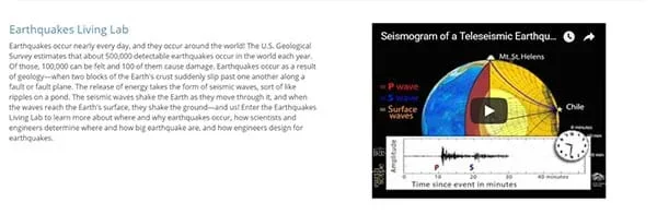 Figure 1. The entry web page for the Earthquakes Living Lab.
 - Have students click on the Earthquakes Living Lab hyperlink in the top left in the earthquakes section. Now on the main page of the Earthquakes Living Lab website (see Figure 2), note the focus on four active seismic areas.
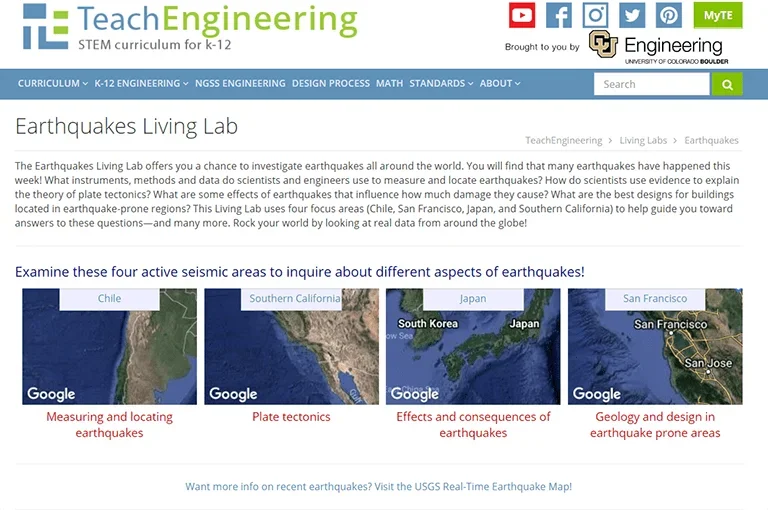 Figure 2. The main page of the Earthquakes Living Lab website.
 - Direct students to complete the first half of the worksheet (the Explore, Explain and part of the Evaluate sections), which is also summarized below.
- Of the four Earthquakes Living Lab seismic areas, choose the "Chile" box.
- Follow the first link on the right side of the page titled, "Where did earthquakes occur this week?"
- Examine the data on the screen. Note that each circle represents an earthquake that occurred during the last seven days.
- Examine the data and record your answers to the worksheet questions:
- What do the dot colors indicate?
- What does the circle size indicate?
- When you click on a circle, what information is provided?
- Approximately how many earthquakes occurred within the last hour?
- Approximately how many earthquakes occurred within the last day?
- Where did the greatest magnitude earthquakes occur this week?
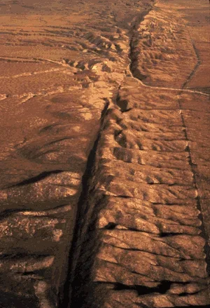 An aerial view of the San Andreas Fault in California.Copyright USGS http://pubs.usgs.gov/gip/dynamic/San_Andreas.html
- Looking at the website, note the general location and frequency of earthquakes. Record any patterns or trends you see and why you think they are occurring.
- In the upper right corner, click on the small gear-shaped button. From the drop-down options, click on the "Map Layers" button (about halfway down) and turn on the "U.S faults" overlay. Write down what you think "faults" are and why earthquakes are located along some faults but not all along all fault lines. (Example answer, as provided on the Worksheet Example Answers (PDF): A fault is a crack in the Earth's crust, resulting from the displacement of one side with respect to the other. Large faults form from the result of plate tectonic forces. Only active faults cause earthquakes and many faults are inactive. Some fault lines do not have much seismic activity no movement. While most earthquakes occur along fault lines, not all fault lines have earthquakes.)
- For the second part of the worksheet (the rest of the Evaluate and entire Elaborate sections), have students perform a detailed analysis of the first 25 most recent earthquakes listed. Have them use Excel, to calculate the mean, median and mode. Have them record how they think the data would change if they were given an entire year's worth of data. (Example answer: Although the mean, median and mode could change significantly, it is difficult to predict. If several large earthquakes happened in the last week, the mean and median would probably decrease with a year's worth of data. Similarly, they would probably increase if no large earthquakes occurred in the last week. The maximum and minimum, however, would almost certainly change, given data for an entire year.)
- Conclude the activity with a class discussion, as described in the Assessment section.
- fault plane
- The surface where tectonic plates slip past one another.
- lithosphere
- The outermost rigid layer of the Earth, consisting of the crust and upper mantle. This layer of the Earth is composed of tectonic plates and is where earthquakes occur.
- seismograph
- An instrument that measures motions of the ground, including those of seismic waves generated by earthquakes. Also called seismometer. The instrument detects and documents the intensity, direction and duration of ground vibrations, which are used to determine the strength or magnitude of earthquakes or other seismic events.
- tectonic plates
- Large sections of the Earth's crust (lithosphere layer) that move, float and sometimes fracture, and whose interaction causes much of the planet's seismic activity.
Pre-Activity Assessment
Predictions: Before student pairs look at the Earthquakes Living Lab, direct them to complete the Engage section of the Where Are Earthquakes Happening Right Now? Worksheet (PDF), which asks them to apply their prior knowledge to identify regions of the world and the U.S. where earthquakes occur. From what they know, they are asked to make predictions about what might be patterns or trends in earthquake locations. Review their answers to assess their base knowledge of the subject matter. Students will revisit their predictions later in the activity.
Activity-Embedded Assessment
Data Analysis: Student pairs complete worksheets by using the Earthquakes living lab interface to locate recent earthquakes, as well as perform statistical analysis on the 25 most recent earthquakes listed. After working with the data, they make predictions on how their analysis results (mean, median, mode, and maximum and minimum magnitude values) might be different based on a full year of earthquake data.
Post-Activity Assessment
Sharing Information/Class Discussion: Lead a class discussion to share students' answers, observations and conclusions. Refer to the Where Are Earthquakes Happening Right Now? Worksheet Example Answers (PDF). Go around the classroom, having different pairs share their answers for each worksheet question. Do we have a consensus on where earthquakes are most likely to occur? Do you see any discrepancies in the numerical data? Would the mean and median increase or decrease given a year's worth of data? How might engineers use this data?
Have student groups explore the other three regions (Southern California, Japan and San Francisco) and concepts presented in the Earthquakes Living Lab.
- For lower grades, work through the mean, median and mode calculations as a class, or skip that section.
- For upper grades, have students work individually, perform more in-depth statistical analysis such as finding standard deviation and variance, and graph their data (activity vs. time, earthquakes vs. area, etc.)
This activity is designed around the Earthquakes Living Lab, a resource and online interface that uses real-time U.S. Geological Survey seismic data from around the world. The living lab presents earthquake information through a focus on four active seismic areas and historic earthquakes in those areas. The real-world earthquake data is viewable via a graphical interface using a scaling map.
Contributors
Mike Mooney; Minal Parekh; Scott Schankweiler; Jessica Noffsinger; Karen Johnson; Jonathan Knudtsen
Supporting Program
Civil and Environmental Engineering Department, Colorado School of Mines
Acknowledgements
This curriculum was created with the support of National Science Foundation grant no. DUE 0532684. However, these contents do not necessarily represent the policies of the National Science Foundation, and you should not assume endorsement by the federal government.
Copyright
2013 by 2013 Regents of the University of Colorado; original © 2013 Colorado School of Mines