
Earthquakes Living Lab: The Theory of Plate Tectonics
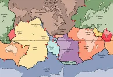 Figure 1: Map of the 15 largest tectonic plates.Copyright 1996 U.S. Geological Survey via Wikimedia Commons {PD} http://commons.wikimedia.org/wiki/File:Plates_tect2_en.svg
Students gather evidence to explain the theory of plate tectonics. Using the online resources at the Earthquakes Living Lab, students examine information and gather evidence supporting the theory. They also look at how volcanoes and earthquakes are explained by tectonic plate movement, and how engineers use this information. Working in pairs, students think like engineers and connect what they understand about the theory of plate tectonics to the design of structures for earthquake-resistance. A worksheet serves as a student guide for the activity.
Understanding the processes that shape the Earth helps engineers design the structures in our communities to withstand powerful natural events such as earthquakes. For construction projects, especially those near active faults and coastlines, engineers consider the effects of plate tectonics. If one tectonic plate suddenly slips with respect to another plate, the release of energy can cause earthquakes that impact structures. To design adequate foundations, engineers must first understand the properties and behavior of ground and subsurface materials. They design structures with added factors of safety to account for the anticipated magnitude of earthquakes and volcanic activity in certain areas.
Scientists and engineers around the globe gather data through observation and experimentation and use it to describe and understand how the world works. The Earthquakes Living Lab gives students the chance to track earthquakes across the planet and examine where, why and how they are occurring. Using the real-world data in the living lab enables students and teachers to practice analyzing data to solve problems and answer questions, in much the same way that scientists and engineers do every day.
After this activity, students should be able to:
- Identify evidence of continental movement and explain continental drift.
- Explain plate movement and the consequences of that movement on landforms.
- Describe how engineers design buildings for earthquake-prone areas.
- Major geologic events such as earthquakes, volcanic eruptions, mid-ocean ridges, and mountain formation are associated with plate boundaries and attributed to plate motions
Grade 7
Do you agree with this alignment?
- STEL-6D Engage in a research and development process to simulate how inventions and innovations have evolved through systematic tests and refinements.
Grades 6-8
Do you agree with this alignment?
- MS-ESS3-2 Analyze and interpret data on natural hazards to forecast future catastrophic events and inform the development of technologies to mitigate their effects.
Grades 6-8
This resource focuses on the following Three Dimensional Learning aspects of NGSS:
Science & Engineering Practices- Construct an oral and written argument supported by empirical evidence and scientific reasoning to support or refute an explanation or a model for a phenomenon or a solution to a problem.Do you agree with this alignment?
Disciplinary Core Ideas- Mapping the history of natural hazards in a region, combined with an understanding of related geologic forces can help forecast the locations and likelihoods of future events.Do you agree with this alignment?
Crosscutting Concepts- The uses of technologies and any limitations on their use are driven by individual or societal needs, desires, and values; by the findings of scientific research; and by differences in such factors as climate, natural resources, and economic conditions. Thus technology use varies from region to region and over time.Do you agree with this alignment?
Do you agree with this alignment? - Construct an oral and written argument supported by empirical evidence and scientific reasoning to support or refute an explanation or a model for a phenomenon or a solution to a problem.
Each group needs:
- computer or other device with Internet access
- journal or writing paper for each student
- pen or pencil, one per student
- The Theory of Plate Tectonics Activity Worksheet (PDF), one per student
(It is helpful to have a world map handy to show students the continents of the Earth.) Have you ever noticed how the continents of Africa and South America could fit together—almost like puzzle pieces? Scientists first noticed this in the early 20th century, and after decades of research, arrived at the theory of plate tectonics.
According to the theory of plate tectonics, the Earth's crust is divided into plates that are continually moving either towards or away from each other. An earthquake is what happens when two tectonic plates suddenly slip past one another. The slipping causes shaking, or vibration in the form of surface and body waves. The waves travelling through the Earth can damage the human-made structures that compose our communities, such as buildings, bridges, roadways, pipelines, schools and homes. Knowing that this might happen, engineers design structures that are better able to resist or withstand the forces generated by earthquakes. Some structures are engineered to be stronger or stiffer, while other structures are engineered to be more flexible and react to earthquake forces by bending.
Before the Activity
- Make copies of The Theory of Plate Tectonics Worksheet (PDF), one per student.
- Make arrangements so that each student group has a computer with Internet access.
- Decide whether to have students pairs work together in one journal or keep individual journals.
With the Students
- Divide the class into student pairs, and have them assemble at their computers with journals/paper and writing instruments.
- Hand out worksheets to the groups and direct them to read through the instructions. Encourage them to explore all of the Earthquakes Living Lab, especially if they need more information to complete the worksheet.
- Before looking at the Earthquakes Living Lab, have pairs complete the Engage section of the worksheet: What continent do you live on? Can you think of any ways the continent has changed over time?
- Guide the teams to the Earthquakes Living Lab via the living lab website at http://www.teachengineering.org/livinglabs/index.php. Have them scroll down to the Earthquakes Living Lab section (see Figure 2). Tell students that this activity is designed around the Earthquakes Living Lab, a resource and online interface that uses real-time, real-world seismic data gathered from around the world.
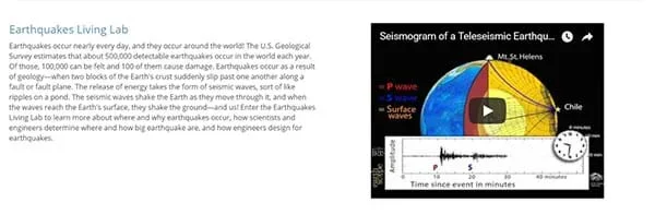 Figure 2. The entry web page for the Earthquakes Living Lab.
 - Have students select the Earthquakes Living Lab hyperlink in the top left in the earthquakes section. Now, on the main page of the Earthquakes Living Lab website (see Figure 3), note the focus on four active seismic areas, each based on one of four historic earthquakes. Let students explore the living lab before they move on.
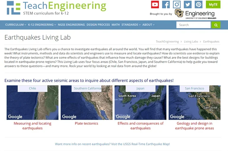 Figure 3. The main page of the Earthquakes Living Lab website. Note the Southern California box.
 - Have students move on to the Explore section: For this activity, select the second option, the "Southern California" box shown in Figure 3.Then click the third link on the right side of the page titled, "How have the Earth's continents changed over time?" at http://www.ucmp.berkeley.edu/geology/anim1.html.
- Have students compare the real-time earthquake map with the map of the tectonic plates (see Figure 1). Ask the students: Do you see any correlations? Why do earthquakes occur along the plate boundaries in the Pacific but not in the Atlantic? (Answer: The plates in the Pacific are moving against each other [subduction], while the plates in the Atlantic are moving away from each other—an example of sea floor spreading.)
- Compare the map of the world today (such as the real-time earthquake map at https://earthquake.usgs.gov/earthquakes/map/) to a map of the world 250 million years ago (called Pangaea). Use the interactive continental drift map to watch the change in the Earth's landforms over millions of years:
- As you watch the animation, record at least three examples of how the continents have changed their positions over time.
- If the plates continue to move in this pattern, draw a sketch of what the world might look like 250 million years in the future.
- Guide students to the Explain section: Navigate back to the Earthquakes Living Lab main page and click on the second and fourth links titled, "What is the theory of plate tectonics? What evidence supports the theory of plate tectonics?" and general information on plate tectonics. (location: http://www.divediscover.whoi.edu/tectonics/index.html) Explore more about the theory. Read the background information and answer the following questions:
- What might have caused the continents to move? (Hint: What is the name of this theory?)
- Describe some important information related to this theory.
- Have students move on to the Elaborate section: Find and record evidence used to explain how the continents have moved over time. In addition to the links you have already opened (for the Explain section), explore the following links listed on the worksheet to identify explanations and examples of evidence. You may also use any of the other links found on the Earthquakes Living Lab. Record your ideas in the graphic organizer on the worksheet to keep track of evidence examples and explanations found in the study of sea floor spreading, fossils, earthquakes and volcanoes.
- Seafloor spreading and earthquakes: https://pubs.usgs.gov/gip/dynamic/developing.html
- Fossils: http://education.seattlepi.com/list-describe-evidence-plate-tectonics-theory-5600.html
- Volcanoes: http://www.divediscover.whoi.edu/hottopics/seamounts.html
- Review the information compiled in your chart and explain one way the theory of plate tectonics can relate to engineering.
- Have students complete the worksheet Evaluate section: In the early 1900s, Alfred Wegener proposed the continents were "drifting." The scientific community did not support his theory due to a lack of scientific evidence. Using what you learned in this activity, would you support Wegener's hypothesis or not? Write a two-paragraph essay that explains your position.
- continental drift
- The gradual movement of the continents across the Earth's surface through geological time.
- earthquake
- When two tectonic plates suddenly slip past one another, creating seismic waves.
- lithosphere
- The outer part of the Earth's sub-surface, consisting of the crust and upper mantle.
- pangaea
- The hypothetical landmass that existed when all continents were joined, from about 300 to 200 million years ago.
- tectonic plates
- Large sections of the Earth's crust (lithosphere) that move, float and sometimes fracture and whose interaction causes much of the planet's seismic activity as well as continental drift, earthquakes, volcanoes, mountains and oceanic trenches.
Pre-Activity Assessment
Intro Questions: Before student pairs look at the Earthquakes Living Lab, have them complete the Engage section of the The Theory of Plate Tectonics Worksheet (PDF), which asks them which continent they live on and to think of any ways the continent has changed over time. Review their answers to assess their base knowledge of the topic.
Activity Embedded Assessment
Exploring the Theory of Plate Tectonics: Have students use the living lab resources to complete the worksheet (PDF) research, filling in the graphic organizer chart and sketching future continental movement. Expect students to be convinced of the theory of plate tectonics, but it is okay for them to disagree, as long as they have good reasons. Specifically, expect students to address the problems the scientific community had with Wegener's hypothesis, and whether those concerns have been answered.
Post-Activity Assessment
Evidence: To complete the worksheet (PDF),students consider tectonic plate movements along with their compiled examples and explanations in order to draw their own conclusions from the evidence presented for the theory of plate tectonics. They also suggest how what they have learned in their research might relate to engineering. Review their answers for comprehension and completeness.
Homework: As a summary assessment, assign the worksheet (PDF)Evaluate section as homework. Students are asked to apply what they have learned to either support or disprove Alfred Wegener's original 1915 hypothesis that the continents are "drifting," in the form of a two-paragraph essay that explains their positions. Review students' answers for the logical use of scientific evidence as well as thoroughness and thoughtfulness.
Have students explore the other two regions in the Earthquakes Living Lab (Japan and Chile). Assign students to research and report on historical earthquakes or buildings and structures designed specifically to withstand earthquakes.
- For lower grades, skip the essay in the Elaborate worksheet section and/or conduct the activity as a class or in larger groups of three or four students each.
- For upper grades, have students work individually and/or have them classify each plate boundary as transform, divergent or convergent, asking them: Which types of plate boundaries are the most concerning to people?
This activity is designed around the Earthquakes Living Lab, a resource and online interface that uses real-time U.S. Geological Survey seismic data from around the world. The living lab presents earthquake information through a focus on four active seismic areas and historic earthquakes in those areas. The real-world earthquake data is viewable via a graphical interface using a scaling map.
Contributors
Mike Mooney; Minal Parekh; Scott Schankweiler; Jessica Noffsinger; Karen Johnson; Jonathan Knudtsen
Supporting Program
Civil and Environmental Engineering Department, Colorado School of Mines
Copyright
2013 by Regents of the University of Colorado; original 2013 Colorado School of Mines