
Watersheds: Where Does the Water Go? (en español)
Students model a water catchment basin and survey water pathways to understand factors that affect water flow.
Each group needs:
- 1 cardboard/plastic tray
- 1 medium white trash bag
- 1 large spray bottle
- 1 medium-sized sponge
- (optional) newspaper
- 1 roll masking tape
- 3 Styrofoam/plastic bowls
- 2 3-oz. (88.7 ml) paper cups
- (optional) 2 paper plates
- 2 12 oz. (~350 ml) plastic cups
- assorted rocks, foam balls, etc. (for making landforms)
- assorted food coloring colors (can be shared)
- access to water
The entire area from where stream or river water begins to where it finally ends is called a catchment basin (or a river basin or water basin.) Catchment basins and watersheds are important to most living things, since water flow, direction and location are vital to water availability for everyday life. Environmental, chemical and civil engineers, along with geologists and hydrologists, are all very interested in catchment basins, how they change, and how water flows through them. Recently, in the Earth's geologic timeline, we are seeing catchment basins changing in response to human water diversion and water collection activities. Understanding how human-made technologies affect our water sources, water quality and watersheds is of great importance to protect the people, industries and wildlife that depend upon a working system of clean water for survival.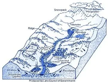 A catchment basin.Copyright Lane Council of Governments, Watershed Information Network, U.S. Environmental Protection Agency, www.epa.gov/win/images/ws1.gif
Procedures Overview
Students act as engineers and build three-dimensional models of water catchment basins and experiment to determine how they can be altered by natural and human activities.
Procedure
- Organize students into groups of three. Have them brainstorm what things they think could affect a stream, and how the area around the stream would be affected.
- As a class, discuss students' ideas. Instructor note: If not brought up by students, discuss water quality (dirt, pollution), precipitation (rain, snow), life (animal, plant), human-made changes (dams, buildings), and location (mountains, valleys).
- Explain to students that a catchment basin is a geographical area that ultimately drains into a river, and that all of the things they discussed in their brainstorming session can affect catchment basins.
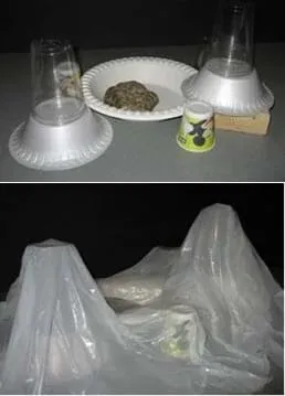 The activity setup.Copyright 2006 Malinda Schaefer Zarske, ITL Program, College of Engineering, University of Colorado Boulder
 - Give each group a tray, trash bag and spray bottle. At the front of the classroom, have the rest of the supplies ready for students to use when appropriate.
- Tell students that the tray is the "region" they are studying. Have students use various supplies to create mountains, valleys and other topographical features in their regions, as illustrated in the photographs above. (Note: Have students use masking tape to secure their features.)
- Instruct each group to cover its region and "features" with a plastic bag. Loosely mold the plastic around the objects and tape as needed.
- Have students make predictions about what will happen to the water in their regions if it were to suddenly start raining. Then, have students gently "rain" on their regions with the spray bottles filled with water.
- Students should observe where the water flows and collects on the plastic covering. Does it form rivers and lakes? Streams?
- As students are making their observations, walk around the room and give each group a sponge. Instruct them to use the sponge to create a dam in one of their rivers. Then, have them "rain" again, and observe how the dam affects the region.
- Next, help students model a pollution-generating factory: place a few drops of food coloring on their sponge; then have students place the sponge where a factory might be. Have students "rain" again, and observe where the pollution ends up (that is, where the colored water flows). How does this affect the region?
Wrap Up - Thought Questions
- How do mountains, hills and valleys dictate water flow in a region?
- How did a dam affect your region?
- Where did the industrial pollution end up? How could this affect your region?
This resource was modified from Can You Catch the Water? to create a shorter, more streamlined version suitable for informal learning settings.
This resource is also available in Spanish.
Copyright
2006 by Regents of the University of Colorado