
Flood Causes and Mitigation Strategies for Civil Engineers
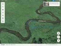 An example of a Google Earth river anatomy label.Copyright 2022, Amanda Oanes, West Fargo, ND, RET Program, College of Engineering, North Dakota State University
Students act as civil engineers who are assessing the viability of a new housing development along a river. Students use a map of the river and the location of the proposed development to demonstrate where erosion and deposition are occurring along the river. They interpret precipitation data to determine whether flooding will occur. Finally, they create a presentation that includes the best course of action for the city and any flood mitigation strategies necessary.
This activity looks at the basics of water resource engineering and the decision-making process that is involved in city planning and development. Civil engineers design flood control structures that manage the risks associated with flooding, evaluating past data and making predictions that inform their design process. They also play a part in educating the public about the benefits and drawbacks of building along a river.
After this activity, students should be able to:
- Identify what factors influence flooding.
- Understand different ways that communities prepare for and handle flood events.
- HS-ESS2-5 Plan and conduct an investigation of the properties of water and its effects on Earth materials and surface processes.
Grades 9-12
This resource focuses on the following Three Dimensional Learning aspects of NGSS:
Science & Engineering Practices- Plan and conduct an investigation individually and collaboratively to produce data to serve as the basis for evidence, and in the design: decide on types, how much, and accuracy of data needed to produce reliable measurements and consider limitations on the precision of the data (e.g., number of trials, cost, risk, time), and refine the design accordingly.Do you agree with this alignment?
Disciplinary Core Ideas- The abundance of liquid water on Earth's surface and its unique combination of physical and chemical properties are central to the planet's dynamics. These properties include water's exceptional capacity to absorb, store, and release large amounts of energy, transmit sunlight, expand upon freezing, dissolve and transport materials, and lower the viscosities and melting points of rocks.Do you agree with this alignment?
Crosscutting Concepts- The functions and properties of natural and designed objects and systems can be inferred from their overall structure, the way their components are shaped and used, and the molecular substructures of its various materials.Do you agree with this alignment?
Do you agree with this alignment? - Plan and conduct an investigation individually and collaboratively to produce data to serve as the basis for evidence, and in the design: decide on types, how much, and accuracy of data needed to produce reliable measurements and consider limitations on the precision of the data (e.g., number of trials, cost, risk, time), and refine the design accordingly.
- HS-ETS1-3 Evaluate a solution to a complex real-world problem based on prioritized criteria and trade-offs that account for a range of constraints, including cost, safety, reliability, and aesthetics, as well as possible social, cultural, and environmental impacts.
Grades 9-12
This resource focuses on the following Three Dimensional Learning aspects of NGSS:
Science & Engineering Practices- Evaluate a solution to a complex real-world problem, based on scientific knowledge, student-generated sources of evidence, prioritized criteria, and tradeoff considerations.Do you agree with this alignment?
Disciplinary Core Ideas- When evaluating solutions it is important to take into account a range of constraints including cost, safety, reliability and aesthetics and to consider social, cultural and environmental impacts.Do you agree with this alignment?
Crosscutting Concepts- New technologies can have deep impacts on society and the environment, including some that were not anticipated. Analysis of costs and benefits is a critical aspect of decisions about technology.Do you agree with this alignment?
Do you agree with this alignment? - Evaluate a solution to a complex real-world problem, based on scientific knowledge, student-generated sources of evidence, prioritized criteria, and tradeoff considerations.
Each group needs:
- a computer/tablet
- Google Earth, if available (or the Google Maps website if the app is not available)
- optional: whiteboard markers and white boards or markers and butcher paper
- access to presentation software such as PowerPoint, Google Slides, Canva, etc.
- access to a video camera, phone, etc. to record videos of presentations
- handouts (one per student):
- Flooding Causes Worksheet (PDF)
- Flood Risk Management Worksheet (PDF)
- Flood Management Scenario Worksheet (PDF)
- A look at the conditions that led to previous major flood years in Fargo article (PDF) (PDF or printout)
- Ten years later, flood of ’09 remembered as a victory paid for with sweat, tears article (PDF) (PDF or printout)
- Day 1 River Anatomy Notes Presentation (pptx)
- Day 1 River Anatomy Notes Presentation (pdf)
- Day 2 Ages of Rivers Notes Presentation (pptx)
- Day 2 Ages of Rivers Notes Presentation (pdf)
- Flooding Causes Worksheet (docx)
- Flooding Causes Worksheet (pdf)
- A look at the conditions that led to previous major flood years in Fargo article (pdf)
- Ten years later, flood of ’09 remembered as a victory paid for with sweat, tears article (pdf)
- Flood Risk Management Worksheet (docx)
- Flood Risk Management Worksheet (pdf)
- Flood Risk Management Worksheet Answer Key (docx)
- Flood Risk Management Worksheet Answer Key (pdf)
- Flood Management Scenario Worksheet (docx)
- Flood Management Scenario Worksheet (pdf)
A basic understanding of the different parts of a river and how a river changes over time.
First, let’s have everyone draw a T-Chart in your notebooks. Label the first column “What I Notice” and the second column “What I Wonder.” I want you to write down what you notice (observations) and wonder (questions) about the ground motion.
(Show students the 2:41-minute video Yellowstone National Park Closed ’Indefinitely’ Following Flooding.)
So, what did you put down? Let’s share your observations and the questions you may have.
Why do you think rivers flood? (Allow students to share their thoughts. Examples: Fall precipitation, snowpack, spring snowmelt time, spring temperatures, spring precipitation, elevation change of a river, direction of river flow [north flowing can experience ice dams], etc.)
If rivers have the possibility of flooding, why do people want to build near rivers? (Allow students to share their thoughts. Examples: availability of water recreation, tourism, ease of transporting goods along rivers, nice views from houses, lack of space to build further away from a river, etc.)
Rivers and their potential to flood are a natural hazard that can greatly affect communities located near them. Flooding can be predicted to a degree, and plans can be made to mitigate the damage created by floods.
To keep people and property near rivers safe, civil engineers design flood mitigation strategies that provide resiliency for their communities. How can civil engineers design solutions that will protect areas from flooding? (Allow students to discuss.)
Civil engineers would look at the area (topography, geography, population, etc.) and determine which areas are susceptible to flooding. They may build infrastructure that accommodates flood water (levees, dams, flood walls, etc.), work with city planning/zoning in the floodplain, and engage in community outreach to prepare for flood events. Once areas susceptible to flooding have been determined, engineers would design solutions that complement the city planning goals. For example, if an area is near the river and likely to flood yearly, it would be zoned for a park, not housing.
Today you are all going to become civil engineers. Let’s get started!
Background
How do rivers work? Cities that are built around rivers must account for the possibility of flooding. Before students can analyze flooding risks and mitigation, they need to know basic background facts about rivers. Students must be aware that rivers are dynamic systems, continually shifting and changing positions when they look at factors that determine the age of rivers.
Stream morphology is the study of the physical features that result from water flowing through a bounded channel and its valley. For the context of this activity, rer4t6focus is on how moving water erodes and deposits material along stream banks. Over time, this erosion and deposition will change the path of the river. Erosion will create cutbanks and deposition will create point bars. Eventually, the stream bed will become shallower and wider and may create oxbow lakes. A river’s path is constantly changing over time.
This activity uses an example of the Red River of the North that flows through Fargo, ND, which can cause many problems for the people that live along its banks. Students must be aware of three factors when looking at flooding. First, students will probably say the amount of precipitation that occurs, which can be from a hard, fast rainfall in the summer. In North Dakota, it also relates to the amount of snow over the winter season, as well as how fast that snow melts in the spring. Second, North Dakota is very flat, so if a river does escape its banks, it can cause widespread overland flooding that can cause farmland to look like lakes and last for weeks. Finally, the Red River is a north-flowing river, so in the spring, when melting begins to happen, the southern part of the river will melt first. As the water makes its way north, it can run into ice jams. This will block the north-flowing river and can also cause the water to spill out of its banks.
Once students know what can cause flooding, their next job will be to look at how civil engineers study the movement of water to keep it in its banks or to determine where people should be able to build houses. If a flood happens, students must research possibilities that could help mitigate the damage that the river could cause.
Finally, the students will take on the role of civil engineers to determine whether a construction company could plan and build a development of houses near a meander of a river. They will have to back up their claims with all the research they have done on the Red River. If there is no flooding for 10 years, does that make it safe? Students can answer the question either way, but they must justify their reasoning.
Before the Activity
- Print handouts
- Optional: Create guided notes for students to complete that follow the River Anatomy Notes Presentation (PPTX) and the Age of Rivers Presentation (PPTX).
- Optional: Rather than printing them, provide students access to PDFs of the A look at the conditions that led to previous major flood years in Fargo article (PDF) and the Ten years later, flood of ’09 remembered as a victory paid for with sweat, tears article (PDF).
- Before Day 2:
- Prepare a Quizlet Live, Kahoot, Gimkit, bingo, etc. to review the vocabulary terms from Day 1.
- Before Day 3-4:
- Post links the to the spinner and to the webpage Never Ending Snow: The Record Smashing Snowfall of ’96-’97 – KVRR Local News in a place that students can easily access (e.g., Google Classroom).
- Before Day 5:
- Provide links to the YouTube videos in a place that students can easily access (e.g., Google Classroom) and ensure that students can play the videos on their devices: “How Do Flood Control Structures Work?” (11:17 minutes) and “How “levee wars” are making floods worse” (6:47 minutes).
With the Students
Day 1: River Structure Notes
- Show students the introduction slide in the River Anatomy Notes Presentation. (PPTX) Read through the scenario on slide one as a group, or have students read through the scenario on their own and determine their answer and reasoning. Discuss answers as a group. (Correct Answer: Dustin is correct; the river will erode on Side A and deposit sediment on Side B over time.)
- Present the rest of the River Anatomy Notes Presentation (PPTX). Have students take their own notes or create guided notes for students to complete. Revisit the introduction slide and do a quick check for understanding to ensure that students understand how erosion and deposition occurs in a river.
- Use Slide 17 of the River Anatomy Notes Presentation (PPTX) to lead students through the Pre-Activity Assessment, River Vocabulary. Note: It can be difficult to find the headwaters of many rivers, as they are often in wooded areas. Some students could use more than one image from the same river to label the different parts of the river.
- At the end of the class, have students share their river and the examples they labeled with a partner.
Day 2: Age of Rivers
- Review River Anatomy vocabulary from Day 1, using a Quizlet Live, Kahoot, Gimkit, bingo, etc.
- Present the Age of Rivers Presentation (PPTX). Have students take their own notes or create guided notes for students to complete.
- Have students work in groups of two or three to draw each of the three ages of rivers—young, mature, and old age. Students can use whiteboard markers on the desks/white boards, markers and butcher paper, or a device. For each river (young, mature, and old age), tell students to label the age and describe the main characteristics of that age. Students should additionally label each river’s headwaters, meander, cutbank, point bar, and mouth.
- In closing, have groups share their work with a different group and describe their three rivers to them.
Days 3-4: Flooding Causes
- Hand out the Flooding Causes Worksheet (PDF). This introduces students to factors that can cause flooding using a spinner activity with discussion questions.
- As they complete Part 1 of the Flooding Causes Worksheet (PDF), students look at a table with flooding issues. They spin the spinner and write whether it is a +1, 0 or -1. Then, they add the numbers together, with the more positive numbers indicating that it is more likely a flood will occur.
- Walk around the class to ensure that students discuss the factors, and why they could increase the chance of flooding.
- Have students move into Part 2 of the worksheet to research a timeline of events from either the 1997 flood or the 2009 flood to determine the factors that caused either flood. Students will choose one event to focus on.
- Allow students access to the PDF (or distribute printouts) of the A look at the conditions that led to previous major flood years in Fargo article (PDF) and Ten years later, flood of ’09 remembered as a victory paid for with sweat, tears article (PDF). Students read articles or watch a video that discusses the factors that led to either flood.
- Have students record a short newscast describing the events that caused the flood they chose using the rubric on the last page of the Flooding Causes Worksheet (PDF).
Day 5: Flood Risk Management
- Ask students what type of flood control structures they see in their communities (or are aware of from other communities, if they do not live in a flood-prone area). Have students share their ideas with a partner and make a class list of all ideas.
- Hand out the Flood Risk Management Worksheet (PDF).
- In Part 1 of the worksheet, students watch the “How Do Flood Control Structures Work?” video on YouTube (11:17 minutes) and complete the table on the Flood Risk Management Worksheet (PDF). Walk around to check students’ work and answer any questions.
- Students move on to Part 2 of the worksheet. They watch “How “levee wars” are making floods worse” on YouTube (6:47 minutes), read a hypothetical scenario, and answer the discussion questions. Ensure that students discuss the pros and cons of the scenario in a respectful manner.
- Have a class discussion about the discussion questions. Be sure to include all viewpoints, and allow students to share their ideas.
Days 6-7: Flood Management Scenario
- Hand out the Flood Management Scenario Worksheet (PDF) to each student. This worksheet directs students to generate a response as a city engineer to a developer wanting to build a housing development south of Fargo in Forest River Park.
- Have students work in groups to create a presentation to the City on whether they approve this project. The presentation must include:
- A map of the river, with labels.
- A discussion on the direction the river is flowing, as well as where the thalweg is located.
- A discussion on whether this area could flood, with supporting data from the river anatomy and precipitation table.
- Flood risk management strategies that would be required if this area were to be developed.
- Check in with groups as they work. Ensure that each student contributes to the presentation via research and presenting.
- Have students present in class. Or, record student presentations as if they were presenting their conclusions to the City.
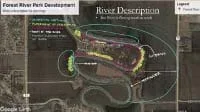 An exemplar of a labeled river from the scenario project.Copyright 2022, Jill Wold, West Fargo, ND, RET Program, College of Engineering, North Dakota State University
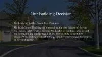 An exemplar of a building decision from the scenario project.Copyright 2022, Jill Wold, West Fargo, ND, RET Program, College of Engineering, North Dakota State University
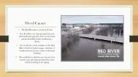 An exemplar of flood causes from the scenario project.Copyright 2022, Jill Wold, West Fargo, ND, RET Program, College of Engineering, North Dakota State University
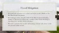 An exemplar of flood mitigation strategies from the scenario project.Copyright 2022, Jill Wold, West Fargo, ND, RET Program, College of Engineering, North Dakota State University
- cut bank
- The curve of a river.
- deposition
- Occurs when the speed of water decreases and rivers drop sediment or load downstream.
- erosion
- Occurs when sediment is picked up and moved to a new location in a river.
- headwaters
- The beginning of a river.
- mouth
- The end of a river where it enters a larger river, lake, or ocean.
- oxbow lake
- Formed when a stream is cut off from a river.
- point bar
- The outer bank of a river.
- thalweg
- The line or curve of lowest elevation within a valley or watercourse.
- water infrastructure
- Any man-made or natural structure that protects cities from flood damage.
Pre-Activity Assessment
River Vocabulary: Have students choose a river to apply their new vocabulary to—this could be a local river, a small stream they are familiar with, or a major river such as the Mississippi, the Nile, or the Amazon. Students will use Google Earth to find examples of the following vocabulary words on the river they choose—headwaters, mouth, meander, cutbank, point bar, oxbow lake, erosion, and deposition. Students will save images of their examples on their device and label them with the vocabulary words.
Note: It can be difficult to find the headwaters of many rivers, as they are usually in wooded areas.
An example of a Google Earth river anatomy label.Copyright 2022, Amanda Oanes, West Fargo, ND, RET Program, College of Engineering, North Dakota State University
Activity Embedded (Formative) Assessment
Activity Worksheets: Students complete the Flooding Causes Worksheet (PDF) and Flood Risk Management Worksheet (PDF). Check that students are actively researching flooding and flood mitigation strategies through the provided readings and videos. Ensure that students are sharing their ideas and discussing content in a respectful manner.
Post-Activity (Summative) Assessment
Flood Management Presentation: Students work in groups to create a presentation based on the scenario from the Flood Management Scenario Worksheet (PDF). Allow students time to practice their presentations before they present in class or record the presentations.
Any trouble students encounter can be handled through guided questions and explanations from the teacher to help them understand the concepts and apply the knowledge.
Students could contact a civil engineer or local municipality to see how flood prevention is designed in their community.
Have more advanced students research cost estimates of flood damage and flood mitigation.
Use the USGS website to find historical information about flooding in your area: https://www.usgs.gov/mission-areas/water-resources/science/usgs-flood-information.
How Do Flood Control Structures Work? Curiosity Stream and Nebula, 2021. YouTube, Practical Engineering, www.youtube.com/watch?v=5mCJh5SJEis. Accessed 3 Dec. 2022.
How "Levee Wars" Are Making Floods Worse. ProPublica, 2018. YouTube, Vox, www.youtube.com/watch?v=LTv6RkFnelM. Accessed 3 Dec. 2022.
"Never Ending Snow: The Record Smashing Snowfall of '96-'97." Written by Rob Kupec. KVRR Local News.
Olson, Dave. "Our High-Water Mark." The Forum [Fargo], Sunday ed., 17 Mar. 2019, sec. A, pp. 1+.
Wood, Gigi. "A Look at the Conditions That Led to Previous Major Flood Years in Fargo." The Forum [Fargo], Late ed., 18 Mar. 2019, sec. A, pp. 1+.
Yellowstone National Park Closed 'Indefinitely' following Flooding. Narrated by Miguel Almaguer, 2022. YouTube, Today, www.youtube.com/watch?v=Y8hg-YvIWgc. Accessed 3 Dec. 2022.
Contributors
Amanda Oanes (West Fargo Public Schools); Jill Wold (West Fargo Public Schools); Sarah Crary, PhD (North Dakota State University); Beena Ajmera (Iowa State University)
Supporting Program
Research Experience for Teacher (RET), Civil Engineering, in partnership with North Dakota State University and the National Science Foundation. Program is led by Dr. Sarah Crary (North Dakota State University) and Dr. Beena Ajmera (Iowa State University).
Acknowledgements
The curriculum was developed under National Science Foundation RET grant #1953102. However, these contents do not necessarily represent the policies of the National Science Foundation, and you should not assume endorsement by the federal government.
Copyright
2024 by Regents of the University of Colorado; original © 2022 North Dakota State University