
Tracking Movements with Metadata
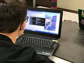 Student from Carson High School, Carson City, NV analyzes metadata.Copyright Daniel Ingram, Carson High School, Carson City, NV
Metadata is an important tool used to organize, calculate, and log information. In this activity, students become detectives as they learn to extract metadata from digital images, analyze the metadata and locate when and where the images were taken. Students gain knowledge on the use of metadata and its application, from engineering to law enforcement. From this activity, students also learn to be proactive in regulating the pictures they take with their smartphones and minimize their image submissions to the web.
Engineers create information unique to their field. Prior to the digital age, engineers had to rely on a plethora of paperwork and analog files to help research, organize, and plan a given project. Today, in the digital world, engineers create and organize metadata formats for specific engineering file types. They also might write code to help them process large amounts of information. This allows specific information to be gleaned from a multitude of files in a very short period of time.
After this activity, students should be able to:
- Define their role as a “cyber-citizen” in regards to the ethical practices of locating and using metadata attached to image files.
- Gather, process, analyze, and disseminate metadata from image files.
- Use web-based tools to convert latitude and longitude coordinates to street addresses or map locations.
- Responsibly regulate their own digital image submissions to the web.
- CCSS.Math.Practice.MP2 Reason abstractly and quantitatively.
Grades K-12
Do you agree with this alignment?
- Students will develop abilities to use and maintain technological products and systems.
Grades K-12
Do you agree with this alignment? - Students will develop an understanding of and be able to select and use information and communication technologies.
Grades K-12
Do you agree with this alignment? - Students will develop an understanding of the characteristics and scope of technology.
Grades K-12
Do you agree with this alignment? - Use computers and calculators to access, retrieve, organize, process, maintain, interpret, and evaluate data and information in order to communicate.
Grades 9-12
Do you agree with this alignment? - STEL-8N Use various approaches to communicate processes and procedures for using, maintaining, and assessing technological products and systems.
Grades 9-12
Do you agree with this alignment?
- CCC.8.9-12.14 Modern civilization depends on major technological systems.
Grades 9-12
Do you agree with this alignment? - SEP.1.9-12.3 Analyze data using computational models in order to make valid and reliable scientific claims.
Grades 9-12
Do you agree with this alignment?
Each student needs:
- a computer with Exiftool (download found at https://exiftool.org/) and images (see Attachments)
- internet access
- Microsoft Office Suite (or Google Docs)
For the entire class to share:
- (optional) 2-3 physical globes for locating latitude and longitude lines, available in your history department or available online.
- Teacher Practice Image 01 (jpg)
- Teacher Practice Image 02 (jpg)
- Teacher Practice Image 03 (jpg)
- Teacher Practice Image 04 (jpg)
- Tracking Movement with Metadata Pre-Assessment (docx)
- Tracking Movement with Metadata Pre-Assessment (pdf)
- Tracking Movement with Metadata Pre-Assessment Answers (docx)
- Tracking Movement with Metadata Pre-Assessment Answers (pdf)
- Tracking Movement with Metadata Activity Rubric (docx)
- Tracking Movement with Metadata Activity Rubric (pdf)
- Tracking Movement with Metadata Activity Excel Spreadsheet Template (xlsx)
- Tracking Movement with Metadata Activity PowerPoint Template (pptx)
- Tracking Movement with Metadata Activity PowerPoint Template (pdf)
- Tracking Movement with Metadata Activity Student Practice Image (jpg)
- Tracking Movement with Metadata Activity Image 01 (jpg)
- Tracking Movement with Metadata Activity Image 02 (jpg)
- Tracking Movement with Metadata Activity Image 03 (jpg)
- Tracking Movement with Metadata Activity Image 04 (jpg)
- Tracking Movement with Metadata Activity Image 05 (jpg)
- Tracking Movement with Metadata Activity Image 06 (jpg)
- Tracking Movement with Metadata Activity Image 07 (jpg)
- Tracking Movement with Metadata Activity Image 08 (jpg)
- Tracking Movement with Metadata Activity Image 09 (jpg)
- Tracking Movement with Metadata Activity Image 10 (jpg)
- Tracking Movement with Metadata Post-Assessment (docx)
- Tracking Movement with Metadata Post-Assessment (pdf)
- Tracking Movement with Metadata Post-Assessment Answers (docx)
- Tracking Movement with Metadata Post-Assessment Answers (pdf)
Students should be familiar with operating a desktop or laptop computer. They should also have the basic knowledge on how to use Microsoft Excel and PowerPoint software, as well as basic knowledge on how to download and upload a file to and from the internet.
Imagine that a family just bought a new car that they had been saving for over the last ten years. Shortly after they buy the car, they go on a vacation out of state. While on vacation, they leave their new car safely at home, locked in their garage. When the family returns from vacation they find that their new car has been stolen, as well as several expensive items from their home. How did the thieves know where the car was? (Wait for answers from the students.) How did the thieves know the family was on vacation? (Wait for answers from the students.) What if I told you that this was the result of digital images uploaded to the internet?
Every digital image contains metadata. Metadata is a set of data that describes and give information about other data. Metadata can be found in many different file types and can provide descriptive, structural, administrative, reference, and statistical data about the file it is embedded in. Not all file types are the same. In order to distinguish between file types, a file extension is given to each file when it is created. The file extension is the suffix that follows the dot at the end of the file name. For an example: A file name of data.docx (write this on white board or chalkboard) the suffix is docx indicating a Microsoft Word document. What are some other file extensions that you are aware of? (Wait for answers from the students. Potential answers include pdf, xlsx, pptx, csv, jpeg, png, gif, etc.)
Most individuals overlook, or do not realize, that they are storing metadata every time they take a picture with their smartphone. Vital information is stored on the jpeg image file, such as the time the picture was taken, the date the picture was taken, and, if the smartphone’s location data is activated, then the location of where the pictures was taken (which is recorded in latitude and longitude coordinates).
The ability to record the location of where the picture comes from is the GPS navigation system within the phone. Does anyone know what GPS stands for? (Wait for answers from the students.) GPS stands for Global Positioning System. GPS is a network of orbiting satellites that send precise details of their position in space back to Earth. The signals are obtained by GPS receivers, such as navigation devices and are used to calculate the exact position, speed and time of the GPS equipped device’s location. GPS devices can be handheld such as cellphones, as well as installed in vehicles, ships, and aircraft.
Let’s go back to the family. After they bought their new car, they were so excited that they posted a picture of it in their driveway to their friends on social media. In addition, on social media, they told friends they were going on vacation, but didn’t say where or when. While they were on vacation, they posted pictures of themselves to social media, but didn’t say where they were. However, because of metadata, cyber-thieves, more commonly known as “hackers,” knew exactly where the car was located, and they knew the family was out of town.
A hacker is a person who uses computers to gain unauthorized access to data. As law abiding citizens in the physical world, we must all also be law abiding citizens in the cyber-world. It is wrong to use metadata for criminal activities, and an individual can be prosecuted for doing this type of criminal activity.
Has anyone heard of digital forensics? (Wait for answers from the students.) Digital forensics is a branch of forensic investigation encompassing the recovery of material found in digital devices, often in relation to computers and data. The individuals who perform these investigations are called digital forensics engineers (DFE). DFEs can work for the government such as the Central Intelligence Agency, law enforcement agencies, as well as private companies.
Today we will analyze two ways to extract metadata from an image. The first way is risky. It’s a website called pic2map. This website is risky because it requires you to upload your image to the site. That means that you can never get the image or metadata back from the site. Just because you delete an image from the internet does not mean that it is gone, it’s still there, just not in that particular spot anymore. An experienced hacker can find deleted files and take advantage of the metadata contained within, what do you think they can do with an image that hasn’t been deleted? (Wait for answers.)
A safer way to extract metadata from an image is a program called Exiftool. It’s free and can work on both Windows and Mac computers. The icon is an executable icon meaning that all you do is drag an image over the Exiftool icon and it will do its job. This is the safe way to extract metadata because you do not need to upload a picture to the internet.
In this activity, your team will work for a private forensic science company that specializes in recovering metadata from images and providing the date and time the image was created as well as the location of where the image was created. In this scenario, the FBI has come to your company for assistance with extracting the crucial metadata in order to determine if a specific person can be linked to several bank robberies committed across the nation. The FBI is not seeking opinions, the FBI is only seeking date, time and locations of where this person has been. It is your team’s job to extract the metadata from the images. Each group will record the information, the metadata, into a working Excel type spreadsheet and then use the information to determine the date, time and physical address of where the image was created. Once the date, time and physical address are found, the team will create a PowerPoint presentation that has a slide for each image that displays where the location is in relationship to a map of the United States.
Let’s read through the Activity Rubric (PDF) and get started!
Background
Metadata is hidden data about the data in a computer file. This is an important topic for high school students to know that metadata can be used for positive things such as in the engineering field where an immense amount of information is created and in various computer file types. To be able to pull specific information from multiple files at a time greatly enhances engineering productivity. This activity introduces students to metadata through teaching them the skills to extract and analyze the metadata information contained in an image. Furthermore, the activity provides an awakening to the high school student about their personal responsibility to protect their personal information in the cyber-world especially before posting images of themselves to the internet. For more information, see the following PBS article, “The secret things you give away through your phone metadata:” https://www.pbs.org/newshour/science/your-phone-metadata-is-more-revealing-than-you-think.
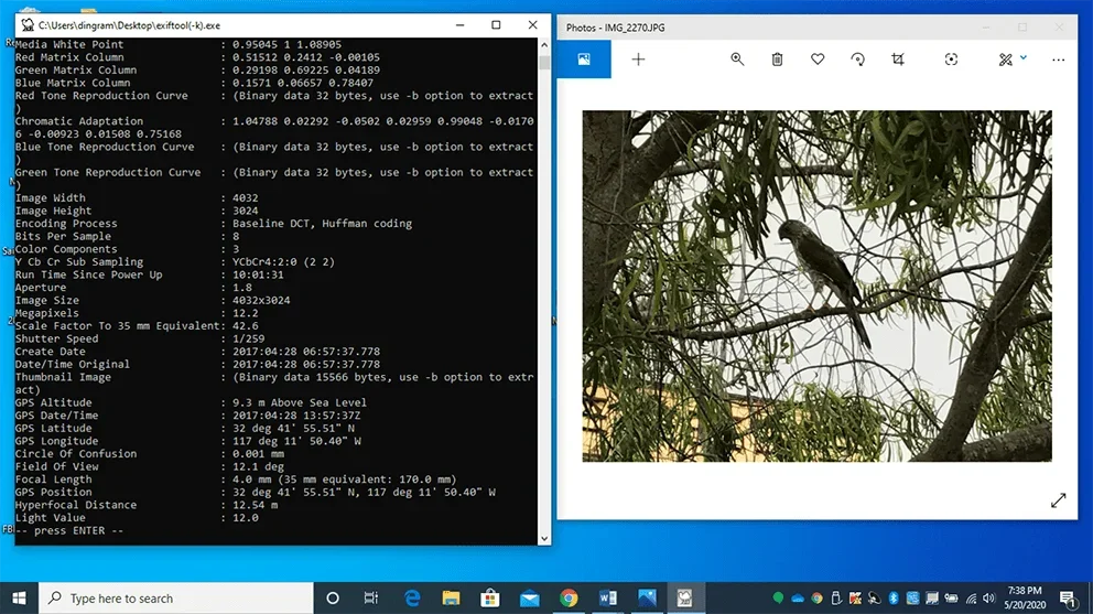 An example of metadata in Exif format extracted from an image.Copyright Daniel Ingram, Carson High School, Carson City, NV
Before the Activity
- Familiarize yourself with the two websites: pic2map at https://www.pic2map.com/ and GPS Coordinates at https://gps-coordinates.org/ as well as how to use Exiftool.
- Download the Exiftool, utilizing the executable download. The download can be found at https://exiftool.org/.
- Load and familiarize yourself with the four teacher practice images included with this activity. These are for you to practice as well as demonstrate to the students.
- Load the folder with all the activity images (see Attachments), Excel Template (XLSX), and PowerPoint Template (PPTX) to the desktop of each computer.
- Ensure that all computers used by the students have the Exiftool loaded on them and the icon is present on the desktop.
- Ensure that all computers used by the students have Microsoft Excel, PowerPoint, and Word software loaded on them. (Any suitable substitute can be used such as Google Docs, Google Sheets, and Google Slides)
With the Students
- Pass out the Pre-Assessment (PDF) and have all students complete it.
- Demonstrate the Pic2Map application.
- Open up the pic2map website at https://www.pic2map.com/ and project the website on the board.
- Upload an image to the Pic2Map online EXIF viewer and run the extractor.
- Once the image has been processed, a screen comes up providing information about the camera used, the date the picture was taken, the address of where the picture was taken, and the GPS latitude and longitude positions of the address. There is also a satellite mapping image to zoom in and out with (see Figure 1).
- Remind students that this website is risky because it requires the user to upload an image to its site. This means that once the image is uploaded, it cannot be taken back. Therefore we need to be sure that any information on the image will not negatively affect us if it falls into the hands of a hacker. Clicking the ‘more information’ button provides all of the metadata contained on the image. Even though the site provides a delete photo button that makes your photo disappear, assume that this data could be compromised.
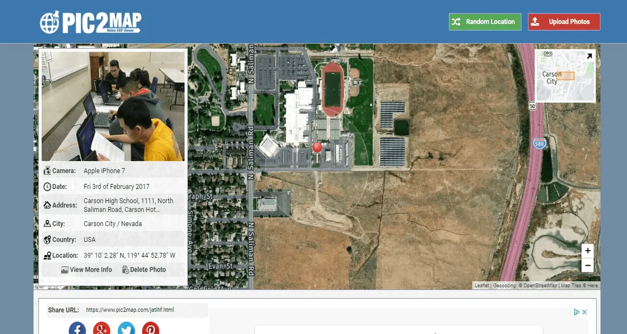 Figure 1. The Pic2Map WebsiteCopyright Daniel Ingram, Carson High School, Carson City, NV
- Demonstrate Exiftool
- ExifTool should already be installed and the Exiftool icon should be on the desktop of teacher’s computer.
- The folder of practice pictures should already be on the desktop of the teacher’s computer as well.
- Open Exiftool and project onto the board.
- Point out the icon with the camel as the image.
- Open up the image folder and select an image. Drag it over the ExifTool icon until it says open with ExifTool (see Figure 2) and then let go of the image.
- Exiftool will pop up with all of the metadata about the image (see Figure 3).
- Record the camera model, original date and time the image was taken, and GPS latitude and longitude position information.
- Enter the GPS information from the metadata. Remember from basic geography in middle school that latitude and longitude can be expressed in Degrees (D) Minutes (M) and Seconds (S). At the end of the latitude there will always be a N for north or a S for south. At the end of the longitude there will always be an E for East or a W for West. Click on the get address button and it should instantly pop up and a reference point is provided on a map of where the location is. This process takes longer, but is safer.
- Optional: use a physical globe to demonstrate Degrees, Minutes, and Seconds as well as longitude and latitude. In addition, compare the physical globe to coordinates found on mapping software, such as Google Maps.
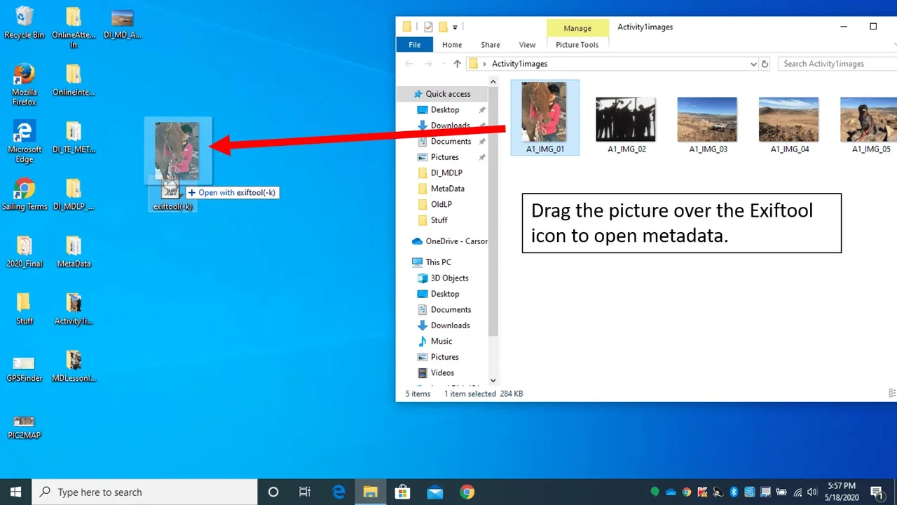 Figure 2. In order to extract metadata using ExifTool you must drag the image over the ExifTool icon until it displays “open with ExifTool” then let go. Once you let go the ExifTool readout will open up.Copyright Daniel Ingram, Carson High School, Carson City, NV
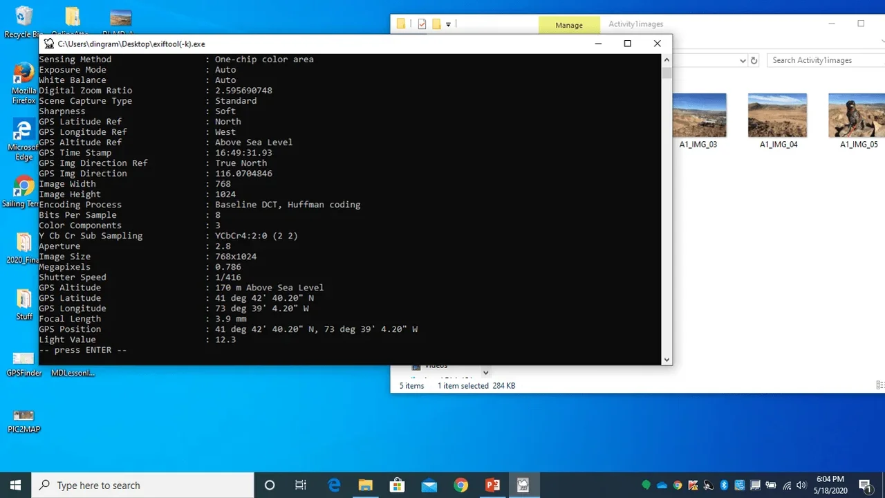 Figure 3. The ExifTool readout. Scroll up and down to find the desired information.Copyright Daniel Ingram, Carson High School, Carson City, NV
- Demonstrate the GPS Coordinates.
- In order to get a physical address for GPS coordinates the GPS latitude and longitude position data must be converted. An easy way to do this is to write down the GPS coordinates and then input them into the GPS coordinates website found at https://gps-coordinates.org/.
- The GPS information provided by the ExifTool is in DMS format, that is Degrees, Minutes, and Seconds. Use the DMS section on the GPS coordinates website. Make sure to select the correct N for North or a S for South and E for East or a W for West. These are included on the GPS position data in ExifTool.
- After inputted data click on the “Get Address” box, not the big start box (see Figure 4). Immediately, the physical address will be provided as well as a location marker on an interactive map that can be zoomed in and out.
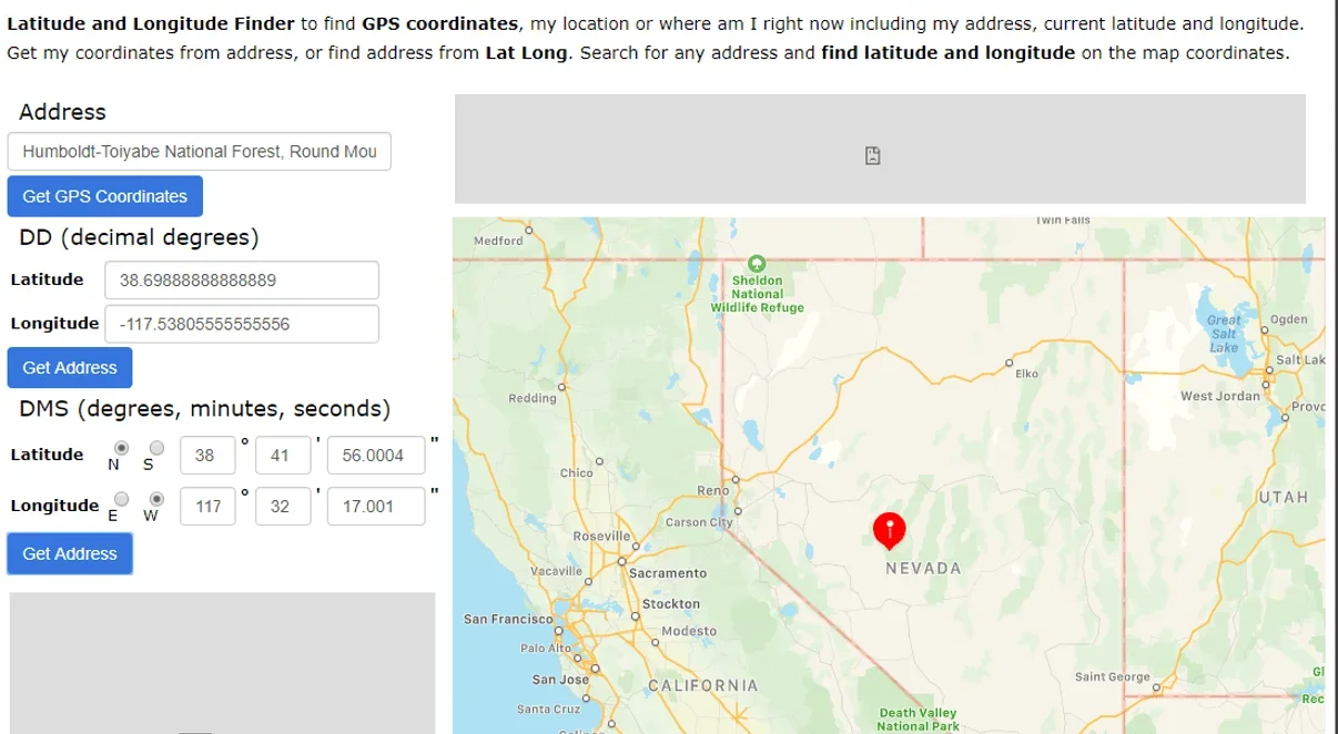 Figure 4. The GPS Coordinates website provides a physical address for the GPS coordinates input into the Degrees, Minutes, and Seconds (DMS) section of the website.Copyright Daniel Ingram, Carson High School, Carson City, NV
- Begin the Metadata Analysis Groupwork
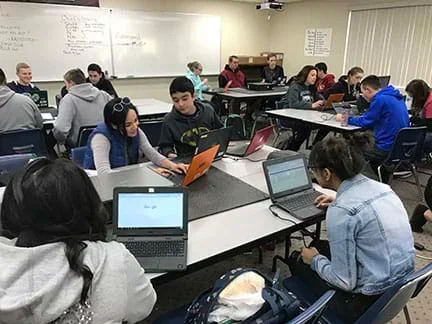 Students from Carson High School, Carson City, NV are engaged in the Tracking Movements with Metadata ActivityCopyright Daniel Ingram, Carson High School, Carson City, NV
- Break students up into groups of three. Ensure each student has a computer.
- Pass out a copy of the Activity Rubric (PDF) to all students. Ensure each student understands the rubric.
- Have each student verify that the computer has the EXIFTOOL on the desktop.
- Have each student verity that there is a folder with the activity images on the desktop as well as a copy of the Excel data collection sheet example and PowerPoint presentation example (see Attachments). Ask each student open up the activity folder on their desktop.
- Have students search the images and find DI_TE_Atch_10_TMwMD_Activity_StuPrac_IMG.jpg.
- Have students use ExifTool to find the original date and time the image was taken as well as record the GPS location.
- Have students use the GPS coordinates website and input the GPS location.
- Once they have the physical address, enter it into the Excel Template (XLSX) and plot it on the PowerPoint Template (PPTX). Note: At some point, have each group decide who will start off working on what portion of the activity project with one student start off being the metadata extractor, one who will input data into do spreadsheet, and one who will do the presentation.
- Instruct students to rotate jobs after two images have had their metadata extracted, information recorded in the spreadsheet, and plotted on the corresponding presentation slides.
- Rotate until all images are have been completed. This will ensure all team members will have a chance to do each person’s job and each team member will have the chance to assist the other team members as needed.
- Walk the students step by step with the student practice image before the students start on their own. See Attachments for practice image.
- Pass out the Post-Assessment and have the students complete it.
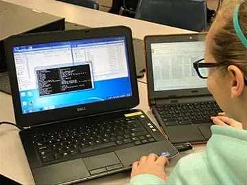 A Carson High School student is analyzing extracted metadataCopyright Daniel Ingram, Carson High School, Carson City, NV
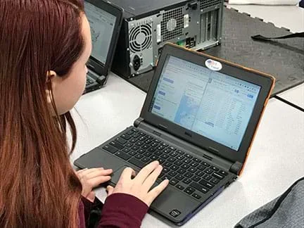 A Carson High School student converts GPS position data to a real address using https://gps-coordinates.org/ and then record the address information into a spreadsheetCopyright Daniel Ingram, Carson High School, Carson City, NV
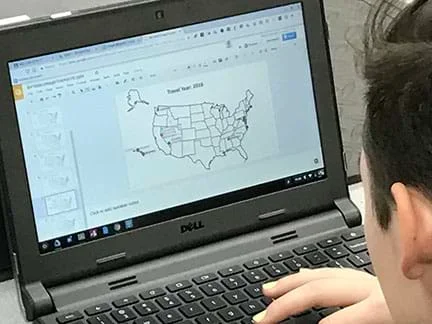 A Carson High School student working on a PowerPoint presentation, inputs visual representation of positional data on an image of the United States.Copyright Daniel Ingram, Carson High School, Carson City, NV
- Conclusion:
- Now that students have completed the activity and the Post-Assessment (PDF), ask what they learned from the activity? Remember, metadata is found in all kinds of files used for all kinds of data collection. Students should be especially careful with what they post to the internet,
- global positioning system (gps)
- A network of orbiting satellites that send precise details of their position in space back to earth. The signals are obtained by receivers, commonly called GPS such as navigation devices, and are used to calculate the exact position, speed and time of the device’s location. GPS devices can be handheld such as cellphones, as well as installed in vehicles, ships, and aircraft.
- file extension
- The suffix at the end of a file name. Example: A in file name of data.docx the suffix is docx indicating a Microsoft Word document.
- hacker
- A person who uses computers to gain unauthorized access to data.
- digital forensics
- The study that encompasses the recovery and investigation of material found in digital devices, often in relation to computer crime.
- metadata
- A set of data that describes and gives information about other data.
Pre-Activity Assessment
Pre-Assessment: The Pre-Assessment (PDF)is made up of ten questions contained within the content of the activity. Students are not expected to do well on these questions; however, this assessment will be used to show growth in learning.
Activity Embedded (Formative) Assessment
Spreadsheet and Powerpoint: The Tracking Movement with Metadata Activity provides a vast amount of opportunities for the teacher to ask formative questions while students are working on the activity. The Excel Spreadsheet (XLSX)and PowerPoint Presentation (PPTX) will both be evidence of understanding by the students. Demonstration by the students using the EXIFTOOL to extract metadata and GPS Coordinate finder to convert GPS Positions to a physical address will also show student learning growth.
Post-Activity (Summative) Assessment
Post-Assessment: The Post-Assessment (PDF) is made up of ten questions contained within the content of the activity. This assessment will be compared to the student’s Pre-Assessment to determine the growth in learning.
ExifTool – If it does not open:
- Make sure you see “open with ExifTool” before letting the image go.
- Check to make sure the executable ExifTool was downloaded.
- Re-download the executable ExifTool again.
GPS Coordinates – If the image does not produce a viable address such as coming up in the middle of an ocean, check to make sure North is checked not South, or West is checked and not East.
Contributors
Daniel S. Ingram
Supporting Program
Research Experience for Teachers (RET), Research Experience in Cybersecurity for Nevada Teachers (RECNT), University Of Nevada
Acknowledgements
This activity was developed under the National Science Foundation RET grant number 1855159. Any opinions, findings, and conclusions or recommendations expressed in this material are those of the authors and do not necessarily reflect the views of the National Science Foundation.
Copyright
2020 by Regents of the University of Colorado; original © 2020 University of Nevada Reno