
Heat Transfer Lab and Weather Model: Let’s Get Breezy!
With the assistance of a few teacher demonstrations (online animation, using a radiometer and rubbing hands), students review the concept of heat transfer through convection, conduction and radiation. Then they apply an understanding of these ideas as they use wireless temperature probes to investigate the heating capacity of different materials—sand and water—under heat lamps (or outside in full sunshine). The experiment models how radiant energy drives convection within the atmosphere and oceans, thus producing winds and weather conditions, while giving students the hands-on opportunity to understand the value of remote-sensing capabilities designed by engineers. Students collect and record temperature data on how fast sand and water heat and cool. Then they create multi-line graphs to display and compare their data, and discuss the need for efficient and reliable engineer-designed tools like wireless sensors in real-world applications.
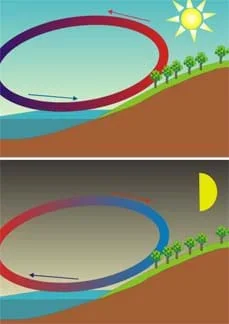 Air temperature differentials generate daytime sea breezes and nighttime land breezes.Copyright 2010 Corso, Wikimedia Commons http://commons.wikimedia.org/wiki/File:Sea_Land_Breeze.svg
At times, it can be difficult to monitor atmosphere and ocean systems due to limited access, extreme weather or lack of a communication infrastructure. Engineers are revolutionizing the way we monitor the natural environment by creating environmental remote sensors (ERS) for improving weather forecasting. Engineers design sensor networks to extract information from the natural environment via an array of sensors and store that information in a repository on a server. These systems have the potential to provide scientists with new environmental and climate data as well as important hazard alerts. ERSs are most important in remote or dangerous environments that have never been studied before due to their inaccessibility, such as NASA's project in Antarctica and future projects on Mars and Europa. Students approach the problems presented in this activity as engineers, scientists or other researchers would, using wireless sensors to collect environmental data.
After this activity, students should be able to:
- Describe how land and sea breezes are formed.
- Write a testable hypothesis about the heating rates of sand and water.
- Use wireless temperature probes to collect data and create line graphs of the measured temperature changes of sand and water.
- Analyze collected data and draw conclusions to accept or reject a hypothesis.
- CCSS.Math.Content.6.EE.C.9 Use variables to represent two quantities in a real-world problem that change in relationship to one another; write an equation to express one quantity, thought of as the dependent variable, in terms of the other quantity, thought of as the independent variable. Analyze the relationship between the dependent and independent variables using graphs and tables, and relate these to the equation.
Grade 6
Do you agree with this alignment? - CCSS.Math.Content.7.RP.A.2 Recognize and represent proportional relationships between quantities.
Grade 7
Do you agree with this alignment? - CCSS.Math.Content.8.SP.A.1 Construct and interpret scatter plots for bivariate measurement data to investigate patterns of association between two quantities. Describe patterns such as clustering, outliers, positive or negative association, linear association, and nonlinear association.
Grade 8
Do you agree with this alignment?
- The use of symbols, measurements, and drawings promotes a clear communication by providing a common language to express ideas.
Grades 6-8
Do you agree with this alignment? - STEL-8N Use various approaches to communicate processes and procedures for using, maintaining, and assessing technological products and systems.
Grades 9-12
Do you agree with this alignment?
- MS-PS3-4 Plan an investigation to determine the relationships among the energy transferred, the type of matter, the mass, and the change in the average kinetic energy of the particles as measured by the temperature of the sample.
Grades 6-8
This resource focuses on the following Three Dimensional Learning aspects of NGSS:
Science & Engineering Practices- Plan an investigation individually and collaboratively, and in the design: identify independent and dependent variables and controls, what tools are needed to do the gathering, how measurements will be recorded, and how many data are needed to support a claim.Do you agree with this alignment?
- Science knowledge is based upon logical and conceptual connections between evidence and explanations.Do you agree with this alignment?
Disciplinary Core Ideas- Temperature is a measure of the average kinetic energy of particles of matter. The relationship between the temperature and the total energy of a system depends on the types, states, and amounts of matter present.Do you agree with this alignment?
- The amount of energy transfer needed to change the temperature of a matter sample by a given amount depends on the nature of the matter, the size of the sample, and the environment.Do you agree with this alignment?
Crosscutting Concepts- Proportional relationships (e.g. speed as the ratio of distance traveled to time taken) among different types of quantities provide information about the magnitude of properties and processes.Do you agree with this alignment?
Do you agree with this alignment? - Plan an investigation individually and collaboratively, and in the design: identify independent and dependent variables and controls, what tools are needed to do the gathering, how measurements will be recorded, and how many data are needed to support a claim.
- design and implement experimental investigations by making observations, asking well-defined questions, formulating testable hypotheses, and using appropriate equipment and technology;
Grades 6-8
Do you agree with this alignment? - analyze data to formulate reasonable explanations, communicate valid conclusions supported by the data, and predict trends.
Grades 6-8
Do you agree with this alignment? - recognize that the Sun provides the energy that drives convection within the atmosphere and oceans, producing winds and ocean currents;
Grade 8
Do you agree with this alignment?
For the teacher's introductory presentation and demonstration:
- computer and projector to show a short animation
- desk lamp, work light or adjustable spot light
- radiometer
Each group needs:
- 2 wireless temperature probes, such as the Master Forge digital remote meat thermometer (item# 245256, model# 5491-CU)
- 8 AAA alkaline batteries
- red and blue colored pencils or crayons, one of each color for each student, to draw convection currents for the worksheet
- paper, pen and tape, to label probes
- Measuring Sand and Water Temperature Lab Template (PDF), one per person
- Drawing Sea Breeze and Land Breeze Worksheet (PDF), one per person
- graph paper, one sheet per student
- Let's Get Breezy Post-Activity Assessment (PDF), one per person
To share with the entire class:
- tap water
- play sand, 50-lb bag, available at local hardware stores
- 2 flat containers or tubs (see Figure 1), one for sand and the other for water, for the lab investigation or 9 x 13" aluminum pans
- 2 250-watt lamps, available at local hardware stores
- 2 250-watt light bulb, available at local hardware stores
- Drawing Land and Sea Breeze Worksheet (docx)
- Drawing Land and Sea Breeze Worksheet (pdf)
- Drawing Land and Sea Breeze Worksheet Answer Key (docx)
- Drawing Land and Sea Breeze Worksheet Answer Key (pdf)
- Measuring Sand and Water Temperature Lab Template (docx)
- Measuring Sand and Water Temperature Lab Template (pdf)
- Measuring Sand and Water Temperature Lab Template Answer Key (docx)
- Measuring Sand and Water Temperature Lab Template Answer Key (pdf)
- Let's Get Breezy Post-Activity Assessment (docx)
- Let's Get Breezy Post-Activity Assessment (pdf)
- Let's Get Breezy Post-Activity Assessment Answer Key (docx)
- Let's Get Breezy Post-Activity Assessment Answer Key (pdf)
Students must be:
- Familiar with the concept of density.
- Able to define and distinguish between conduction, convection and radiation.
- Able to give examples of conduction, convection and radiation.
(Have ready handouts, demonstration materials and ability to show an online animation, as described in the Materials List and Procedure section.)
Think of a hot summer day. Have you experienced walking barefoot on a hot surface? (Yes or no?) Who can give me some examples of hot surfaces that almost burned your feet? (Listen to student examples, such walking barefoot on asphalt, concrete, beach sand or soil.) What was your reaction and how did you get yourself out of that situation? (Listen to student responses. If no one says s/he cooled off his/her feet with water, prompt the students to this idea.) Did any of you place your feet in water or step onto a wet surface? (Listen to student responses.) What can you conclude about the hot dry surface versus the wet surface or water? (Expect students to conclude that on a hot summer day, the hot dry surface is heated up more than the wet surface or water.)
What scientific principles have we experienced from these situations? Well, if you went from a hot surface and used water to cool off your feet then you have experienced the processes of radiation, conduction and convection. Let's learn more about these heat transfer processes.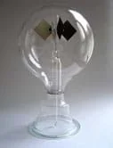 An example radiometer. The vanes rotate when exposed to light.Copyright 2005 Timeline, Wikimedia Commons {PD} http://commons.wikimedia.org/wiki/File:Crookes_radiometer.jpg
Radiation: The sun provides almost all of the Earth's heat energy source. The sun gives off its heat in the form of radiation, which travels through space. Approximately 45% of the sun's radiation that reaches the Earth is absorbed and the remaining 55% is sent back into space. What do you think is the main energy source that generates winds? (Expect students to say that radiation is the energy source. Then direct their attention to the lamp and radiometer setup. Place the radiometer in front of the light so that students can see it turn. Make the following points.) The radiometer vanes are inside a vacuum and are free to rotate with very little friction. Notice that one side of each vane is white and the other is black. The vanes rotate because of unequal heating due to radiation.
Why do you think it is important for engineers to understand radiation? What are some current needs that require us to understand radiation? How might radiation figure into some current events topics? For example, engineers must understand that radiation energy shapes the properties of the Earth's climate. Engineers can then design tools that meteorologists use to predict the weather. (Accept all logical responses and begin writing a list on the classroom board.) Other scientists use to the engineer's tools and instruments to monitor climate conditions around the planet and in the atmosphere. Understanding radiation is also important for understanding what is happening in the planet's atmosphere in terms of human-generated pollution, greenhouse gases and global climate change.
What tools have been engineered that deal with measuring, tracking or predicting weather? (Give students a few minutes to think of some ideas and then share their thoughts.) For example, engineers have improved the rain gauge with digital readouts to increase the accuracy of readings as well enabling meteorologists to access readings from remote locations. Engineers have also designed digital thermometers that collect temperature data from remote locations.
Conduction: Besides radiation, conduction also heats the Earth's atmosphere. In conduction, energy is transferred from one molecule directly to another in a substance. (Use the classroom board to illustrate how molecules in water [liquid] behave differently than molecules of a solid such as sand or dirt. Draw a few blue small circles to represent water molecules and a few yellow circles to represent sand molecules.) Heat makes "entire" molecules move from place to place faster. (On the board, add left and right arrows to each water molecule and each sand molecule.) Temperature is directly related to this motion. This is the case for sand and water. In addition to making water molecules move from place to place, a portion of the heat makes water molecules vibrate and spin around themselves. (On the board, illustrate the vibration motion by drawing short arcs around water molecules and illustrate the spinning motion by drawing curved arrows around water molecules.) These additional water molecule motions do not contribute to temperature. (Have students think back to their summertime experiences discussed earlier and make connections.)
(Lead students into a discussion about conduction with the following questions.)
- Do you think land and water conduct heat equally? (Accept all reasonable responses. Then lead the next demonstration—conduction heat transfer between two objects.)
- Rub your hands together like this. Do you feel how they are conducting heat?
- Now, place your hands on your desks. Do you feel the heat transfer from hands to desk?
- (Revisit the previous questions and have students decide which heats faster, water or sand. Expect students to tell you that sand heats up faster.)
(Hand out the lab templates. Ask students to each generate a hypothesis for the investigation, writing it on the lab template. Students can complete this individually or with a group.)
- During the day, when the Earth is being heated by solar radiation, the air molecules that come into contact with the ground are heated by conduction. In what situations is it important for engineers to understand conduction? (Encourage student responses that include anything that deals with conduction, not limited to weather. Possible answer: For the safe and efficient design of various home appliances like ovens, electric heaters, electric stoves, irons and hair straighteners. Add the examples to the list on the board.)
Convection: The atmosphere that is not in contact with the ground does not become heated by conduction but by convection. Convection is the transfer of energy through a fluid such as ocean water or through a gas such as the planet's atmosphere. For example, when you boil water, the water near the bottom of the pan is heated by conduction; it rises as its density decreases. Cooler denser water rushes in to take the rising water's place. Once the cooler water is heated, the convection cycle continues.
Convection also occurs in the atmosphere. As the air near the ground is heated by conduction, it rises as its density decreases. Cooler, denser air rushes in to take the place of the rising air. Once the cooler air is heated, the convection cycle continues.
(Hand out the worksheets and administer the following pre-assessment.) Let's think about how radiation, conduction and convection are involved in creating breezes. Let's focus on an area of land located next to a body of water. On this worksheet, draw and label how you think convection currents create breezes during the day and night. Use blue to show dense cool air sinking and red to show less-dense warm air rising. Label each picture as either "sea breeze" or "land breeze," and indicate where in the processes radiation, convection and conduction occur. (Monitor students as they are completing the pre-assessment worksheet. Note: students will have a later opportunity to revisit their pre-assessment worksheets to make any corrections. Continue by leading them to understand the following points.) Radiation starts the convection current process in the oceans and the atmosphere. This a cyclical process that continues as long as you have radiation from the sun.
(Show students a 15-second animation of land and sea breezes on convection currents. Explain what is occurring.)
During the day, the sun heats the air above the land quicker than it heats the air above the water. This causes warm land air to rise and cool dense air to rush in and take its place resulting in a "sea breeze." At night, the air above the land cools quicker than the air above the water. So the warmer sea air rises, causing the cooler land air to rush in to take its place, resulting in what is called a "land breeze."
Why do you think it is important for engineers to understand the process of convection? (Keep adding to the list on the board. Possible examples: Engineers must understand convection when designing the freezer section of refrigerators, or when designing a hot water system for a house.)
(Have students look at the compiled list on the board.) Now, let's focus on how radiation and conduction influence convection currents in the Earth's atmosphere thus causing changes in climate and local weather due to unequal heating of land and water.
(Have students discuss or write about the following focus questions.)
- What kind of weather patterns do you think engineers and scientists study?
- Why do you think it is important for them to study these weather patterns?
- Why might it not always be convenient or safe for engineers and or scientists to go into the environment to collect data? (Think of remote and harsh locations around the planet, oceans and atmosphere.)
Engineers design remote sensors to make it safer for scientists to monitor the environment and have access to inaccessible areas. Engineers and scientists base a lot of their research and predictions on the local weather, which is influenced by the unequal heating of land and water. The data that engineers and scientists collect from remote wireless sensors helps them to predict and forecast weather and storms. Have you seen the weather maps shown on the TV news? What do they look like? A weather map is usually depicted by meteorologists to show low and high pressures, cold and warm fronts and expected precipitation. As the Earth's temperature rises, hurricanes, tornadoes and other unexpected weather patterns are more likely to develop and can result in extreme storms and catastrophic events. This makes it all the more important that environmental remote sensors (or ERSs) designed by engineers are available for scientists to collect frequent and reliable data.
Background
Adapt the materials and the procedures for this activity to meet your needs. This experiment was done indoors using 250-watt lamps, but could be done outside in the sunshine if weather permits. Students collected data at a distance from the experimental setup to get the full effect of remote sensors. The remote temperature sensors can be used within a range of 100 feet. Students take temperature readings from their desks using the handheld wireless thermometers, while the temperature probes are placed in the sand/water pans located in the classroom but many feet away from students' desks. Make sure students realize and test the fact that they do not have to be near the sand/water pans in order to take the data readings.
Before the Activity
- Gather materials and make copies of the Measuring Sand and Water Temperature Lab Template (PDF), the Drawing Land and Sea Breeze Worksheet (PDF) and the Let's Get Breezy Post-Activity Assessment (PDF), one each per student. Make sure you have graph paper available for students.
- Practice the demonstration with the lamp and radiometer before presenting it in the Introduction/Motivation. The light source (lamp) and the vane blades in the radiometer must be positioned correctly for the blades to spin. The demonstration represents how the Earth receives most of its energy from the sun and thus the sun causes winds.
- During the Introduction/Motivation, have ready a computer and projector to show a short animation of land and sea breezes at: http://www.classzone.com/books/earth_science/terc/content/visualizations/es1903/es1903page01.cfm?chapter_no=visualization
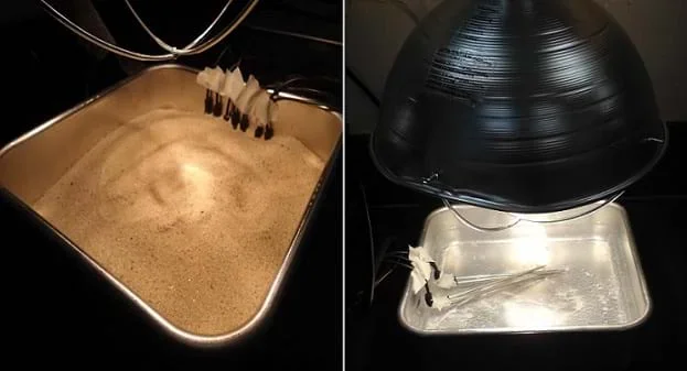 Figure 1. In the experimental setup, wireless temperature sensors measure the heating and cooling rates of sand (left) and water (right).Copyright 2012 RET-ENET Program, The University of Texas-Pan American, Edinburg, Texas
 - Prepare a testing station that can accommodate two flat pans and two light sources for use by all groups. Choose a classroom or lab area where the two lamps can be securely suspended over the two pans, as shown in Figure 1, and then removed during the experiment. Fill one pan halfway with sand and fill the other halfway with water.
With the Students
- Present the Introduction/Motivation content material, which includes the radiometer and hand rubbing demos, showing them an online breezes animation, and a pre-assessment using the worksheet (during the Convection portion of the content). Note that students will have a later opportunity to revisit their pre-assessment worksheets to make any corrections.
- Begin the investigation of the heat capacities of water and sand by dividing the class into groups of three or four students each and giving each group two temperature probes. Note: Because of possible interferences between the remote probes, it is recommended not to power on more than eight probes at the same time. So, for larger class sizes, divide the class into main groups that are further divided into smaller groups of three or four students. The subgroups within the first main group take their measurements first, then they power off their probes before the subgroups within the next main group start taking their measurements. Direct students to follow the section F: Procedure, which is also listed next.
- Explain to students that they will use wireless probes to remotely take temperature measurements in sand and water. Which heats up faster? Which cools down faster? This experimental setup models what happens when the sun heats land and water and the cycle of temperature differentials in the air generates breezes. It also models how scientists and other researchers use engineer-designed inventions and equipment to collect data remotely.
- Use paper, pen and tape to label your probes to distinguish them from the probes of other groups.
- As a class or in lab groups, complete the first page of the lab template, including sections A-E, safety precautions and materials list.
- Have groups place their first probes in the pan of sand. Position each probe so it is submerged into the sand and its wire end is secured to one side of the pan with the probe tip extending to the center of the pan without touching the other probes. Make sure the probes are turned on.
- Turn on the lamp over the sand pan for 10 minutes and have students record the temperature change observed in one-minute intervals. Since all of the probes are within range, expect to see a variance in temperature readings. Always take the highest number when recording the temperature every minute. For example, if the temperature reading fluctuates as follows: 30, 32 and 31, then record the highest number, 32, as the current temperature. Record your data in your section G data chart titled "With lamp (sand probe)."
- After 10 minutes, turn off the lamp and remove it from over the pan of sand and record the temperature change of the sand every minute for another 10 minutes. If the lamp is not completely removed then the residual heat from the light bulb continues to heat the sand although the light is turned off. Remember to always take the highest temperature reading, as explained earlier. Record your data in the section G data chart titled "Without lamp (sand probe)."
- Have groups place their second probes in the pan of water. Position each probe so it is submerged into the water and its wire end is secured to one side of the pan with the probe tip extending to the center of the pan. Make sure the probes are turned on.
- Turn on the lamp over the water pan for 10 minutes and have students record the temperature change observed in one-minute intervals. By this time, make sure students realize that they do not have to be too close to the water in order to take the data readings (100-foot range!). Remember to always take the highest temperature reading, as explained earlier. Record your data in your section G data chart titled "With lamp (water probe)."
- After 10 minutes, turn off the lamp and remove it from over the pan of water and record the temperature change of the water every minute for another 10 minutes. Remember to always take the highest temperature reading, as explained earlier. Record your data in the section G data chart titled "Without lamp (water probe)."
- Hand out graph paper. Direct students to use the grid paper to create a multi-line graph to display your data. Use the variables from section E of the lab template to label the x- and y-axes. Identify which line belongs to which data set.
- Have students write answers to the post-lab assessment questions in section H: Conclusion.
- Conclude by administering the post-activity assessment as described in the Assessment section.
- conduction
- The transfer of heat energy that requires direct contact between two or more objects.
- convection
- A large-scale transfer of heat energy through a moving fluid (a gas or a liquid).
- land breeze
- A breeze that is generated when the land is cooler than the water (such as at night), and the winds are very light. The air over the water slowly begins to rise as it is warmed by the water and becomes less dense, and the air over the surface of the water is replaced by higher density, cooler air from over the land. A land breeze is formed by pulling the air from the land over the water (usually 5 to 8 knots.) The reverse of a sea breeze.
- radiation
- The transfer of energy as electromagnetic waves or subatomic particles. The complete process in which energy is emitted by one body, transmitted through an intervening medium or space, and absorbed by another body.
- radiometer
- An instrument used to demonstrate the transformation of radiant energy into mechanical work. The device is a vacuum or partial vacuum glass vessel containing four low-friction spinning vanes on an axis. The vanes are each black on one side and white/polished on the other. The vanes rotate faster in the presence of more intense light.
- sea breeze
- A breeze that is generated when the surface of the land is heated sufficiently warm so that the air above it rises because it is less dense, and it is replaced by more dense cooler air from over the water. Sea breezes tend to be much stronger than land breezes and can produce gusty winds (10 to 20 knots). The sun can heat the land to very warm temperatures, thereby creating a huge temperature contrast to the water, which does not absorb as much heat. The reverse of a land breeze.
Pre-Activity Assessment
Drawing Breezes: While presenting the Convection portion of the Introduction/Motivation section content, administer the drawing pre-assessment using the Drawing Sea Breeze and Land Breeze Worksheet (PDF). After discussing radiation, conduction and convection and showing the lamp/radiometer demonstration and the land and sea breeze animation, have students think about how radiation, conduction and convection are involved in creating breezes during the day and night. Then have students use pencils or crayons to draw blue arrows to show dense cool air sinking and red arrows to show warm less-dense air rising. Have students label their drawings "land breeze" or "sea breeze," and indicate where in the processes radiation, convection and conduction occur. Later, students will revisit their drawings to make any corrections.
Activity Embedded Assessment
Data Collection and Graphing: Have students complete the Measuring Sand and Water Temperature Lab Template (PDF) while they conduct the experiment and collect data. Students are asked to graph their data and answer the following questions:
- Which substance heated up faster? (Answer: The sand heated up faster than the water.)
- Which substance cooled off faster? (Answer: Sand cooled off faster than water.)
- If both substances received the same amount of heat energy, why were their heating rates different? (Answer: Water needs to absorb a lot of energy before its temperature changes. Sand does not need as much energy for its temperature to change.)
- Why do sand and water have different cooling rates? (Sand cools off faster than water because sand is a solid).
- Share your group's results with the class. You may now want to revise your ideas, based on the discussion. (Answer: Water heats up slower and cools off slower than sand. Sand heats up faster and cools off faster than water.)
- Beneath your answers and data, explain any revisions you want to make to your original thinking. (Students may or may not have any revisions to make.)
- Based on what you learned from this experiment, explain how it can help you in the "real world." (Accept all logical responses)
- If you would like to learn more about this topic, explain why. (Accept all logical responses)
- If you still have a question about this topic, please state it below. (Accept all logical responses)
Refer to the Measuring Sand and Water Temperature Lab Template Answer Key (PDF) as a guide in assessing students' completed lab templates.
Post-Activity Assessment
Drawing Follow-Up: After students have completed their lab reports, have them revisit their pre-activity assessment, the Drawing Sea Breeze and Land Breeze Worksheet (PDF), making revisions if necessary, based on what they have learned. Review their drawings to gauge their mastery of the concepts. As necessary, review the concepts as a class, referring to the example and explanations provided in the Drawing Sea Breeze and Land Breeze Worksheet Answer Key (PDF).
Concluding Flow Chart and Questions: To conclude the activity, administer the Let's Get Breezy Post-Activity Assessment (PDF), which asks students to work with partners to create flow charts and give five-minute presentations describing the flow charts. Then have students write answers to the following five focus questions. Refer to the Let's Get Breezy Post-Activity Assessment Answer Key (PDF) to assess students' answers.
- What are disadvantages scientists or other researchers might face because of not having access to environmental remote sensors to collect data from remote locations?
- Describe a situation in which you need to collect information quickly using a wireless device. Describe the type of information that you are trying to collect and describe a device that could be used to expedite the process of getting that information faster.
- Based on today's activity about wireless sensors, how can engineers help scientists or other researchers collect data quickly and accurately?
- How do you think engineers can improve the current remote wireless temperature probe design?
- For what other real-world applications do you think it is important for engineers to design environmental remote sensors?
Remind students to not touch the incandescent light, which can get very hot.
Depending on the weather and the amount of sunlight, conduct this activity outside using solar energy instead of lamps.
Make sure that the radiometer works. Typically, the vanes must be suspended in a sealed vacuum in order to operate correctly.
See the Procedure section note about the possible interferences between the remote probes if using more than eight at the same time.
Assign students to conduct the following thinking exercises:
- If you were an engineer, what environmental remote sensor would you design that could improve the quality of life of humankind? (For example, design a sensor that could be placed at remote locations to measure the amount of pollution in the air.)
- Think about the impact of this new environmental remote sensor and explain how it would be beneficial to people. Does it have any civil benefits? Does it impact the entire society or is it most helpful to a subgroup? Does it benefit the entire region or nation? (Accept all logical responses from students.)
- For lower grades, conduct the activity inside the classroom for safety issues. Divide the class into four groups. Give each group 200 g of sand in a Styrofoam cup and 200 g of water in a second Styrofoam cup. Use the wireless temperature probes to measure the temperatures of the sand as it receives heat energy from a lamp for 10 minutes. Then, use the wireless temperature probes to measure the temperatures of the water as it receives heat energy from a lamp for an additional 10 minutes.
- For upper grades, have student groups design their own experimental setups that allow them to measure the temperatures of both the sand and the water as they receive equal amounts of heat energy either from a lamp or direct sunlight. Make sure they identify the independent variable, dependent variable and constant for the setup. Challenge them to compare the heating rates of dry sand versus wet sand.
Show students the 15-second Exploring Earth interactive land and sea breeze animation at Class Zone: http://www.classzone.com/books/earth_science/terc/content/visualizations/es1903/es1903page01.cfm?chapter_no=visualization
Heating of Land and Water. 2012. Experiments: Middle School Science with Vernier, Vernier Software and Technology. (Recommended for grades 5-8) Accessed June 6, 2012 (activity inspiration) http://www.vernier.com/experiments/msv/2/heating_of_land_and_water/
Martinez, Kirk, Jane K. Hart and Royan Ong. "Environmental Sensor Networks." IEEE Computer. Vol. 37, No. 1, August 2004, pp.50-56. http://www.computer.org/csdl/mags/co/2004/08/r8050-abs.html
Contributors
Constance Garza; Mounir Ben Ghalia
Supporting Program
RET-ENET Program, Electrical Engineering Department, The University of Texas-Pan American
Acknowledgements
This activity was created through The University of Texas-Pan American's Electrical Engineering Research Experiences for Teachers in Emerging and Novel Engineering Technologies (RET-ENET) Program with support from National Science Foundation grant no. CNS 1132609. However, these contents do not necessarily represent the policies of the National Science Foundation, and you should not assume endorsement by the federal government.
Copyright
2013 by Regents of the University of Colorado; original © 2012 The University of Texas-Pan American