
Watershed Delineation
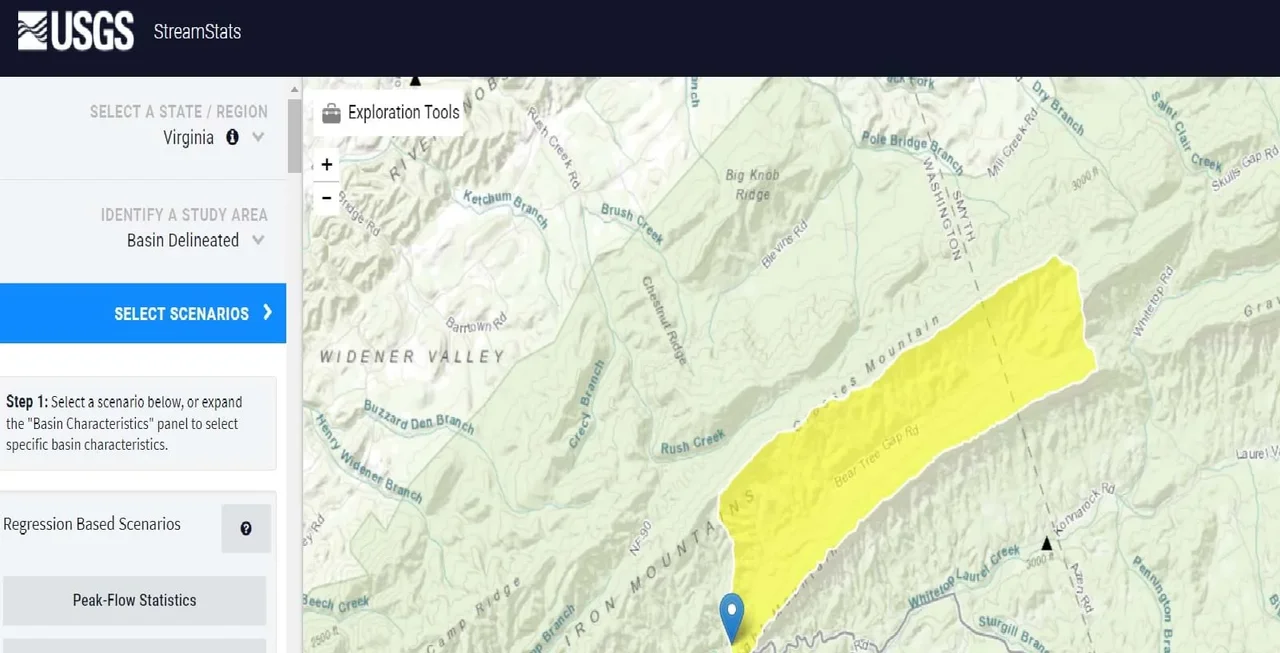 A USGS marker on mapping software of a delineated watershed in VirginiaCopyright 2021 Rachelle Rasco, Virginia Tech RET
Understanding watersheds can help engineers design systems that deliver or protect key sources of water. In this activity, students become civil engineers as they use topographic maps to delineate watersheds. Watersheds show the path water travels over land in a particular area on its way to a river, lake, or stream. Defining the boundaries of a watershed is important for determining the amount of runoff that can come from that area into the river, lake, or stream. The boundaries also help to identify sources of pollution that could mix in with that runoff as it passes over the land area.
Civil engineers must be able to estimate the quantity of water that could leave a watershed when sizing bridges, culverts, and stormwater pipes. They also use this information to design stormwater facilities that will buffer peak flows that would cause flooding due to runoff. Recently, more requirements have been made about the levels of nutrients allowed to leave a developed site, so sites also need to be designed to limit and remove nutrient loads that could be carried in the runoff. Being able to define the watershed and the sources of water in that area are necessary and are the first steps to planning for and mitigating runoff from a watershed.
After this activity, students should be able to:
- Delineate a watershed using a topographic map.
- Delineate a watershed using USGS StreamStats.
- Determine some characteristics of a watershed.
- Determine direction of streamflow using a topographic map.
- Build a report of watershed characteristics.
- Present data succinctly to an audience.
- List 5-10 characteristics of streams in their area.
- With the aid of technology, various aspects of the environment can be monitored to provide information for decision-making.
Grades 9-12
Do you agree with this alignment?
- HS-ESS2-2 Analyze geoscience data to make the claim that one change to Earth's surface can create feedbacks that cause changes to other Earth systems.
Grades 9-12
This resource focuses on the following Three Dimensional Learning aspects of NGSS:
Science & Engineering Practices- Analyze data using tools, technologies, and/or models (e.g., computational, mathematical) in order to make valid and reliable scientific claims or determine an optimal design solution.Do you agree with this alignment?
Disciplinary Core Ideas- Earth's systems, being dynamic and interacting, cause feedback effects that can increase or decrease the original changes.Do you agree with this alignment?
Crosscutting Concepts- Feedback (negative or positive) can stabilize or destabilize a system.Do you agree with this alignment?
- New technologies can have deep impacts on society and the environment, including some that were not anticipated. Analysis of costs and benefits is a critical aspect of decisions about technology.Do you agree with this alignment?
Do you agree with this alignment? - Analyze data using tools, technologies, and/or models (e.g., computational, mathematical) in order to make valid and reliable scientific claims or determine an optimal design solution.
- maps and globes are read and interpreted, including location by latitude and longitude;
Grades 9-12
Do you agree with this alignment? - identification of sources of fresh water including rivers, springs, and aquifers, with reference to the hydrologic cycle;
Grades 9-12
Do you agree with this alignment? - dependence on freshwater resources and the effects of human usage on water quality; and
Grades 9-12
Do you agree with this alignment? - identification of the major watershed systems in Virginia, including the Chesapeake Bay and its tributaries.
Grades 9-12
Do you agree with this alignment?
Each group needs:
- paper topographic map of the area they live in with a creek or stream flowing through it. (USGS –usgs.gov – provides free resources to view topographic maps with various base layers: USGS-The National Map, USGS-National Map Viewer.)
- colored pencils
- computer/laptop with internet access
To share with the entire class:
- Watershed Delineation Presentation (PPTX)
- computer/laptop and projector to show a PowerPoint
The students should be familiar with what a watershed is and what a topographic map is.
When it rains, where does all the water go? Have you ever had to stop driving because there is water covering the road? Have you ever had to leave your home because of rising water? If not, you can thank a civil engineer! Civil engineers design infrastructures to manage the influx of stormwater runoff.
To do this, they must calculate how much water flows through the area before and after a storm. The first step in calculating this drainage is to define the area which is referred to as “delineating a watershed.” Delineating a watershed can assist the civil engineers in calculating the drainage area, slope and land cover which are key factors in determining the time it takes rainwater to travel from the delineation boundary to the downstream outfall.
In this activity, you will be defining the watershed area first by outlining it by hand on a topographic map and then using a new online application available to engineers, USGS StreamStats, creating a computer-generated delineation.
What is a watershed? A watershed is a unit of land that distributes water to streams, creeks, or rivers and eventually to lakes and oceans. These land units are also called catchments, drainage basins, and river valleys. Drainage divides or continental divides are ridges that separate watersheds. The largest watershed in the United States is the Mississippi River Watershed, which encompasses 40% of the lower 48 states. Just as a kilometer can be subdivided into meters and meters can be subdivided into centimeters, watersheds can be subdivided into smaller units as well. The Mississippi, for example, can be subdivided into the Upper Mississippi, Lower Mississippi, Ohio River Basin, Missouri River Basin, Arkansas River Basin, and the Red River Basin. Even further, for example, the Ohio River Basin can be subdivided into smaller units like the Tennessee River Valley. The Tennessee River valley can be broken down into smaller units, such as the Holston River Valley. The Holston River Valley can be subdivided into smaller units, such as Hall Creek.
Eventually, you work your way down to the water molecule that splashes on the surface after falling from the atmosphere through precipitation. A watershed is a home for that water molecule on or near the earth’s surface as it moves from reservoir to reservoir. As mentioned before, reservoirs can be lakes, streams, and groundwater, but reservoirs can also include living things, which rely on water for their very existence. So, it is important for us to know where our water comes from and what could be affecting it upstream. To do this, we must be able to delineate the watershed, which means simply drawing lines on a map to show the watershed’s boundaries. Now let’s see where our water comes from!
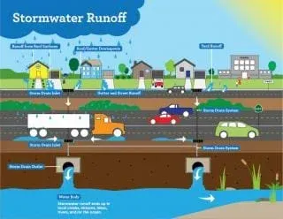 All water flows through a watershed to a river, even city stormwater.Copyright 2021 City of Easton, Pennsylvania https://www.easton-pa.com/public-works/pages/stormwater-management
Background
Watershed delineation is an important concept as watersheds are the unit of study in hydrology. Land cover and land uses within watersheds affect the hydrologic cycle or the flow of water in that area. Defining a watershed boundary is the first step in determining a watershed’s characteristics. After a watershed is properly delineated, engineers can calculate the drainage area, slope and land cover. These characteristics along with other factors will affect the time it takes rainwater to travel from the delineation boundary to the downstream outfall. This activity involves delineating a watershed by hand using a topographic map (how engineers used to do it) and then using the USGS StreamStats site, an online tool engineers use today. After delineation, a few watershed characteristics will be determined. Note-If class time is limited, delineating the watershed using the USGS StreamStats site by itself is still a valuable lesson.
Delineating a watershed means identifying and drawing the watershed boundary on a topographic map. The first activity will be to draw the boundaries by hand using a topographic map of the area. The second activity will be to use an online tool, USGS StreamStats, to delineate the area. Before online tools were developed, this is the method engineers would use to assess the watershed. The students can compare their hand drawn delineation (which is how engineers used to delineate the watershed) to the computer-generated outline. Other features on the USGS map will also be explored, such as distance, elevation, peak flows, etc.
The teacher chooses watershed areas. In this activity, we chose the watershed based on the stream we were studying in front of our school. A watershed can be a small area that feeds into a local stream or river or you could choose a larger watershed, for example, in Virginia the Chesapeake Bay is an important watershed to study.
The stream outlet is the lowest elevation in that area or chosen as a bridge or stream that you are analyzing with the class. The Stream stats also lets you follow a drop of water which will show you where the water goes when it leaves your area. For example-we might just delineate the stream we are studying but if we follow the drop of water, it shows us the larger rivers it flows into before finally ending up in the Gulf of Mexico (larger watershed area).
Watersheds show the path water travels over land in a particular area on its way to a river, lake or stream. Defining the boundaries of a watershed is important for determining the amount of runoff that can come from that area into the river, lake, or stream. In this activity, students will delineate a local watershed using a printed topographic map. The second part of this activity will be to use an online tool, USGS StreamStats, to delineate the area. The students can compare their hand drawn delineation (which is how engineers used to delineate the watershed) to the updated computer-generated outline. Other features on the USGS map will also be explored, such as distance, elevation, peak flows, etc.
To find the direction of streamflow using a topographic map: The contour lines show the elevation of the area. Water flows from the highest point to the lowest point. So, if you find a peak (circular contour pattern with no more contour lines inside), the water will flow down on either side. Water on one side of the peak flows down one side, while water on the other side of the peak flows the down the other side. By drawing a line attaching the peaks in an area, then all the water flows down to the lowest point in that area (ex. stream at the bottom.)
Before the Activity
- Prepare all materials for class.
- Put students into groups of 2.
- Deliver all materials to students, including a link to USGS StreamStats.
With the Students
- Hand each student a paper copy of the topographic map of the local area.
- (Slide 5) Go over what a topographic map is. Show the students that each contour line represents different elevations and the closer contour lines are together the steeper the elevation is.
- Have students find the peaks on their topographic map.
- (Slide 6) Show students how to delineate the watershed area. (See the Watershed Delineation Presentation (PPTX))
- (Slides 7-8) With a colored pencil, have students delineate the watershed on the topographic map. (They should find the highest elevations and mark them with an x and then connect the x’s).
- Class discussion: Discuss what types of land surfaces fall in that watershed such as roads, farms, etc. Ask students if they think that would affect the movement of water. Would some of it be absorbed into the ground? Would water levels rise faster?
- (Slides 9-12) On the computer, have students go to https://streamstats.usgs.gov/ss/.
- Type in your location to zoom into the map.
- Click the state or region of study.
- Zoom into your creek.
- Click the delineation button and click on a spot on your creek (blue lines represent water).
- Wait for the application to delineate the area (see figure 1 for an example.)
- Have students compare the USGS StreamStats delineated area to the one the students drew themselves. Ask students how useful they think an application like this is to civil engineers.
- Let students explore the exploration tools at the top left of the screen to find different characteristics of the area (these include size, shape, physiology, land use, drainage, hill, valley, basin, outlet).
- Click the measure tool.
- Select two points on your stream to measure their distance.
- Click the elevation profile tool.
- Select two points on your stream to see a profile of the different elevations.
- In the left-hand toolbar, have students choose the blue “continue” button. Then have the students:
- Choose basin characteristics.
- Click DRNAREA (and any other characteristics they are interested in).
- Click continue then show basin characteristics. This is the size of the area of the watershed which is important in figuring out the drainage for that area.
- Have students go back to the exploration tools and try out the flow (raindrop) path button to see the path a drop of water takes from this location to its ending point in the ocean.
- Have students click the start point location, using the pour point or click on another spot on the map. Then have them click go. Water from streams and creeks head to rivers and eventually to the ocean. Have students think about where their water ends up.
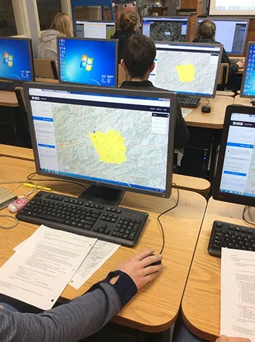 USGS image of a delineated watershed.Copyright 2021 Rachelle Rasco, Virginia Tech RET
- delineation
- The action of indicating the exact position of a border or boundary.
- drainage divide
- A boundary between drainage basins/ watersheds: all the precipitation on opposite sides of a drainage divide will flow into different drainage basins.
- reservoir
- A natural or artificial place where water is collected and stored for use.
- watershed
- An area or ridge of land that separates waters flowing to different rivers, basins, or seas; land area that channels rainfall and snowmelt to creeks, streams, and rivers, and eventually to outflow points such as reservoirs, bays, and the ocean.
- watershed delineation
- Action of drawing lines on a map to identify a watershed's boundaries.
Pre-Activity Assessment
Thought questions: When it rains where does all the water go? Have you ever had to stop driving because there is water covering the road? Have you ever had to leave your home because of rising water?
OR
Spend time learning to read a topographic map. This can be done simply by printing off a topographic map of your area and having students write down landmarks like their home, school, etc. Then ask simple questions like “is your house at a higher elevation from the school?” or “if you pour water out on the parking lot of the school, draw a line to show where it will eventually flow.”
Activity Embedded (Formative) Assessment
Check students delineated watershed from the USGS site to the hand drawn one using the topographic map.
Post-Activity (Summative) Assessment
Slides presentation of the watershed assignment. Have students describe what a watershed is, a picture and their reasoning for the hand drawn watershed, and finally the delineated watershed.
The USGS StreamStats includes a user manual on the site.
(Optional) To get printed topography maps, view the attached Watershed & Topographic Maps Video that Thomas Westfall made showing how to find and print topographic maps.
- Ask the local city/county for a contour map of the school area and/or ask for a tour of the school's stormwater infrastructure. Personnel at the city/county may be familiar with ArcGIS and may be able to easily produce a more detailed contour map. The stormwater or public works department knows the stormwater infrastructure best and may be willing to provide a tour.
- For a regional scale topographic map: https://ngmdb.usgs.gov/topoview/viewer/#4/40.00/-100.00 (though the contours are not well detailed if one is only interested in a small watershed of the school's campus).
- For topographic maps where a screenshot could capture smaller scale watersheds: https://apps.nationalmap.gov/ (most likely the same topographic maps as above, but you can zoom in on this website and capture only what you need)
- Google Maps terrain: (not the best), but there are some neat "Map Creation Features" that students could use on Chromebooks too!
For lower grades, the delineation of the watershed boundaries can be done as a class.
Dictionary.com, LLC. Accessed July 19, 2019. (Source of some vocabulary definitions). http://www.dictionary.com
USGS StreamStats application. https://streamstats.usgs.gov/ss/
Hermance, Jack. Brown University Environmental Geophysics/Hydrology Home Page. http://www.geo.brown.edu/research/Hydrology/FTP_site_5099-05/maine_appD_watershed-delineate.pdf
Contributors
Rachelle Rasco; Thomas Westfall; Aaron Napier; Steve Ahn
Supporting Program
RET Water EcubeG Program, Virginia Tech
Acknowledgements
The work was supported by the Learning Enhanced Watershed Assessment System (LEWAS) Lab at Virginia Tech, which was funded by support of the National Science Foundation through grant no. 1609089—RET Site: EcubeG Program. Any opinions, findings, and conclusions or recommendations expressed in this paper are those of the author(s) and do not necessarily reflect the views of the National Science Foundation.
Copyright
2021 by Regents of the University of Colorado; original © 2018 Virginia Polytechnic Institute and State University