
Let’s Learn about Spatial Viz!
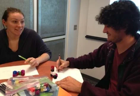 Students practice spatial visualization by building 3-D objects from toy cubes and drawing them two-dimensionally on isometric paper.
Spatial visualization is the study of two- and three-dimensional objects and the practice of mental manipulation of objects. Spatial visualization skills are important in a range of subjects and activities like mathematics, physics, engineering, art and sports! In this lesson, students are introduced to the concept of spatial visualization and measure their spatial visualization skills by taking the provided 12-question quiz. Following the lesson, students complete the four associated spatial visualization activities and then re-take the quiz to see how much their spatial visualization skills have improved.
Spatial visualization is an important skill for students and professionals within the science, technology, engineering and math (STEM) fields. Not only is it useful for engineering drawings, but it is also highly correlated with success in engineering (Sorby, 2009) and has been shown to be a learned skill. It is increasingly important, therefore, to incorporate spatial visualization learning into STEM curricula.
After this lesson, students should be able to:
- Describe spatial visualization.
- List the benefits of spatial visualization in STEM-related fields.
- Draw 3-D objects two-dimensionally.
- HS.4.4.b Visualize relationships between two-dimensional and three-dimensional objects.
Grades 9-12
Do you agree with this alignment? - HS.4.5 Objects in the real world can be modeled using geometric concepts.
Grades 9-12
Do you agree with this alignment? - 7.4.1 Modeling geometric figures and relationships leads to informal spatial reasoning and proof.
Grade 7
Do you agree with this alignment?
- CCSS.Math.Content.7.G.A Draw, construct, and describe geometrical figures and describe the relationships between them.
Grade 7
Do you agree with this alignment? - CCSS.Math.Content.HSG-GMD.B Visualize relationships between two-dimensional and three-dimensional objects
Grades 9-12
Do you agree with this alignment? - CCSS.Math.Content.HSG-MG.A Apply geometric concepts in modeling situations
Grades 9-12
Do you agree with this alignment?
Spatial visualization has been shown to be highly correlated to success in engineering (Sorby, 2009). Visual spatial skills can be measured through cognitive tests, such as the 12-question Spatial Visualization Practice Quiz (PDF) administered in this lesson. This quiz asks students to rotate objects in their minds and then apply the same rotation to new objects. Research has shown that a persistent gender gap exists in spatial visualization skills: female students typically score lower than male students on spatial visualization assessments. If we want to attract more female students to STEM fields, then practicing this skill seems important in order to level the playing field (Metz et al., 2011). The quiz helps instructors determine the level of these skills amongst their students (a score of eight out of 12 is considered a passing grade) and also provides a way to gauge their improvement after practicing spatial visualization.
From research, we now know that spatial visualization is a learned skill. In fact, according to a study by Sorby (2009), students who failed a pre-test, but subsequently enrolled in a spatial visualization course were able to improve their scores by at least 25% and performed better in their first-year STEM university courses. It is important, therefore, for teachers to facilitate spatial visualization lessons and activities into their STEM curricula—starting early for all students.
(Optional: Prepare to use one slide in the Spatial Visualization Presentation (PPTX), a PowerPoint® file, to show students an example quiz question, which is the same as Figure 1. The slide is animated so a mouse or keyboard click brings up the next text or graphic. The rest of the slides support the four associated activities.)
Have you ever had to pack up a car or truck with an odd assortment of bags and objects? Or, has anyone ever asked you for directions through the various hallways and confusing turns of a complicated building? In these scenarios, sometimes we find ourselves picturing something in our minds before doing it or explaining it. Being able to picture—or, to visualize—how to get to school, how to pack a suitcase, or how to build something are all examples of spatial visualization.
Spatial visualization is the ability to mentally manipulate two-dimensional and three-dimensional objects. Most of us do this every day without even thinking about it! Spatial visualization is an extremely important skill for all students and professionals in science, technology, engineering and math fields. As engineers create new things for human use, they first visualize their products before beginning to build.
Some of us are naturally better at spatial visualization than others. As it turns out, however, this skill is learnable, which means a person can get better at it with practice—just like playing an instrument or playing a sport.
In this lesson, we will practice our spatial visualization skills. Then, we will work through four spatial visualization activities. To test how much is learned throughout this lesson and the upcoming activities, you will take a spatial visualization quiz before and after we have explored and practiced the skill. For this quiz, you will be asked to rotate various objects in your mind.
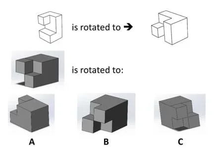 Figure 1. Example question in the format of the Spatial Visualization Practice Quiz.Copyright 2016 Jacob Segil, College of Engineering and Applied Science, University of Colorado Boulder
(Display Figure 1, which is the same as slide 2.) Here is an example of a question you might see on this quiz. In this question, you are asked to imagine how the image in the top left corner would be rotated to look like the image in the top right corner. Then, you are asked to apply the same rotation to the new shape that is shown in the middle. Work through this problem on your own, without sharing the answer that you think is correct. Once you feel you have the correct answer, turn to a partner and discuss. Do you agree? (Once you have given students time to think it through on their own, click to reveal that the answer is B.)
(After making sure that all students understand the format of these questions, administer the Spatial Visualization Practice Quiz (PDF)). Following the lesson and quiz, students can put their skills to the test with the four associated activities that illustrate the different view points of Isometric and Orthographic (Refer to associated activities: Connect the Dots: Isometric Drawing and Coded Plans and Seeing All Sides: Orthographic Drawing) as well as one-axis and two-axis rotations (Refer to tassociated activities: Let’s Take a Spin: One-Axis Rotation and New Perspectives: Two-Axis Rotations)
Many methods exist for obtaining the right answer to each question. Does anyone want to explain the method you used on this quiz? (Field comments from students to obtain a few ways of spatially visualizing. For example, some people imagine picking up the object, rotating it and then picking up the second object and rotating it the same way. Others use tricks such as imagining the object on a table and then picking the side of the object that will eventually be touching the table.) The good thing is, none of these methods are wrong! Do what is easiest for you to visualize the rotation.
If that practice quiz was difficult for you, don’t worry. We are going to work on improving our spatial visualization skills throughout four upcoming activities. Keep these tips in mind as we work through the activities. At the end of the fourth activity, you’ll take the quiz again. (Emphasize to students that what matters is improvement, not necessarily the raw score.)
- spatial visualization
- The ability to mentally manipulate two- and three-dimensional objects. It is typically measured with cognitive tests and is a predictor of success in STEM fields. Also referred to as visual-spatial ability.
Spatial Visualization Pre-Quiz: After presenting the Introduction/Motivation section content, administer the Spatial Visualization Practice Quiz (PDF). After conducting the four associated activities with students, re-administer the same quiz and use the results to quantify each student’s pre-to-post improvement. The aim is improvement more than achieving a specific score.
As an additional or alternative test, purchase for $25 a license to use a scanned digital version of the Purdue Spatial Visualization Test: Rotations from Educational Testing Service at https://www.spatiallearning.org/tools/revised-purdue-spatial-visualization-test-revised-psvtr-visualization-of-rotations.
Teachers may be interested in the spatial visualization information for STEM teachers—a webinar and other online resources—available at the Women in STEM Knowledge Center at http://www.wskc.org/spatial-skills.
Guay, Roland B., Purdue Spatial Visualization Test. West Lafayette, IN: Purdue Research Foundation, 1976.
Metz, Susan. S., Sheryl A. Sorby, Tricia S. Berry, Carolyn C. Seepersad, Ana M. Dison, Yosef S. Allam, John A. Merrill, Wally Peters, Erica Pfister-Altschul, Sarah C. Baxter, Guangming Zhing, and James A. Leach. June 2011. “Implementing ENGAGE Strategies to Improve Retention: Focus on Spatial Skills Engineering Schools Discuss Successes and Challenges” 2011 Annual Conference & Exposition, American Society for Engineering Education, Vancouver, BC. https://peer.asee.org/18100
Siegel, Jacob L., Jacquelyn F. Sullivan, Beth A. Myers, Derek T. Reamon and Marissa H. Forbes. (2016) “Analysis of Multi-Modal Spatial Visualization Workshop Intervention across Gender, Nationality, and Other Engineering Student Demographics.” Proceedings, IEEE Frontiers in Education Conference (FIE), Erie, PA, October.
Sorby, Sheryl A. Published online February 17, 2009. “Educational Research in Developing 3-D Spatial Skills for Engineering Students.” International Journal of Science Education, Vol. 31, Issue 3, pp 459-480. Accessed February 6, 2016. http://www.tandfonline.com/doi/abs/10.1080/09500690802595839?src=recsys&journalCode=tsed20
“Spatial visualization gives students a powerful boost!” Published May 27, 2016. Engineering Plus, College of Engineering and Applied Science, University of Colorado Boulder. Accessed September 25, 2016. http://www.colorado.edu/eplus/2016/05/27/spatial-visualization-gives-students-powerful-boost
Contributors
Emily C. Gill; Jacob Segil
Supporting Program
Engineering Plus Degree Program, University of Colorado Boulder
Acknowledgements
This activity was developed by the Engineering Plus degree program in the College of Engineering and Applied Science at the University of Colorado Boulder.
This lesson plan and its associated activities were derived from a summer workshop taught by Jacob Segil for undergraduate engineers at the University of Colorado Boulder. The activities have been adapted to suit the skill level of middle school students, with suggestions on how to adapt activities to elementary or, in some instances, high school level.
Copyright
2011 by Regents of the University of Colorado