
GPS Satellite Data: Distorted Disturbances Game
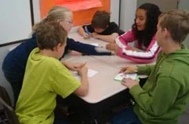 Students have silly fun simulating GPS occultations.
Students pass around and distort messages written on index cards to learn how we use signals from GPS occultations to study the atmosphere. The cards represent information sent from GPS satellites being distorted as they pass through different locations in the Earth's atmosphere and reach other satellites. Reminiscent of the game of telephone, the messages often become nonsensical and funny. Analyzing GPS occultations enables better global weather forecasting, storm tracking and climate change monitoring.
Engineers and scientists use GPS satellites and low-Earth orbit (LEO) satellites to study the atmosphere to better understand weather, climate, pollution, ozone, and solar radiation. Although GPS satellites designed by engineers are most commonly used for navigation, a technique called GPS occultations gathers atmospheric data 24/7 from around the globe. The satellite information received using this technique enables us to learn more about our weather and climate and how the various layers of our atmosphere work and interact with one another.
After this activity, students should be able to:
- Describe how we can analyze disturbed GPS signals in order to understand the type of weather they passed through.
- Compare actual results to expected results to find the reasons for any differences.
- Describe how GPS satellites are used for more than navigation.
- Weather is a result of complex interactions of Earth's atmosphere, land and water, that are driven by energy from the sun, and can be predicted and described through complex models
Grade 8
Do you agree with this alignment? - Weather conditions change because of the uneven heating of Earth's surface by the Sun's energy. Weather changes are measured by differences in temperature, air pressure, wind and water in the atmosphere and type of precipitation
Grade 5
Do you agree with this alignment?
- STEL-3D Explain how various relationships can exist between technology and engineering and other content areas.
Grades 3-5
Do you agree with this alignment? - STEL-3F Apply a product, system, or process developed for one setting to another setting.
Grades 6-8
Do you agree with this alignment?
- MS-PS4-2 Develop and use a model to describe that waves are reflected, absorbed, or transmitted through various materials.
Grades 6-8
This resource focuses on the following Three Dimensional Learning aspects of NGSS:
Science & Engineering Practices- Develop and use a model to describe phenomena.Do you agree with this alignment?
Disciplinary Core Ideas- A sound wave needs a medium through which it is transmitted.Do you agree with this alignment?
- When light shines on an object, it is reflected, absorbed, or transmitted through the object, depending on the object's material and the frequency (color) of the light.Do you agree with this alignment?
- The path that light travels can be traced as straight lines, except at surfaces between different transparent materials (e.g., air and water, air and glass) where the light path bends.Do you agree with this alignment?
- A wave model of light is useful for explaining brightness, color, and the frequency-dependent bending of light at a surface between media.Do you agree with this alignment?
- However, because light can travel through space, it cannot be a matter wave, like sound or water waves.Do you agree with this alignment?
Crosscutting Concepts- Structures can be designed to serve particular functions by taking into account properties of different materials, and how materials can be shaped and used.Do you agree with this alignment?
Do you agree with this alignment? - Develop and use a model to describe phenomena.
Each student needs:
- 2 index cards; alternatively, use half sheets of paper; students write on one card while the other card is given to them already marked by the teacher
- pen or pencil
To share with the entire class:
- (optional) overhead projector to show the class examples of how to alter and make notations on the index card messages, and share the resulting altered messages at activity end
Students should have mastered the content introduced in the associated lesson.
What happens to the radio when you are in a car driving on a road surrounded by mountains? What about when it is raining outside? In both cases, it is likely that your radio would not be able to receive the radio signal clearly. Both the mountains and the stormy weather act as barriers that weaken (and sometimes entirely block) the signal being sent. Do you think that a blizzard would create more of a disturbance (more static) to the radio signal than the average rainy day?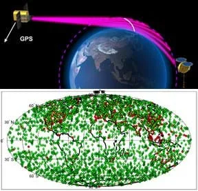 Figure 1. With the GPS occultations technique, signals are transmitted from one satellite and received by another, passing through the Earth's atmosphere where they are delayed and distorted due to gravity and atmospheric conditions. Analysis of thousands of received signals (the map shows a typical example of data locations from one day) conveys atmospheric states.Copyright (top) UCAR and (bottom) Bill Schreiner, UCAR
Now, imagine that you are far away from the radio station and you know the weather is perfect around you and the station too, but for some reason the song you are listening to still has a lot of static. Since you cannot see or hear far enough to know if any bad weather exists somewhere between you and the station, could you use the amount of static generated to find out what is happening?
Let's take this another step further. Picture what it would be like if you were in outer space on a satellite 800 km above the Earth's surface. Instead of a radio signal, your satellite receives GPS signals and the GPS satellite is in a location such that the signal it sends passes through the atmosphere (see Figure 1; draw the basics of this image on the classroom board). Even though you definitely cannot see what the weather is between you and the satellite, you still want to know if something might be making the signal weaker than what you expect it to be. You might also find that the signal takes longer to arrive than expected. Well, using a technique called GPS occultations, engineers can analyze GPS signals to find out what kind of weather is taking place between the GPS satellite and the satellite receiving the signal.
A GPS occultation event takes place when the GPS signal passes through the atmosphere before reaching the receiver. If you know how strong the signal should be and how quickly it should reach you, this information can tell you a lot about atmospheric activity between you and the GPS satellite. This is the kind of information engineers use when they study the atmosphere all around our planet.
Background
Introduce students to the concept of GPS occultations through the information presented in the associated lesson.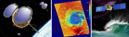 The GPS occultations technique involves sending GPS signals from one satellite to another through the Earth's atmosphere, then analyzing the signals for disturbances and delays that tell us about the atmospheric conditions encountered along the way.Copyright (left) UCAR/NASA, (middle) NASA/JPL, and (right) NOAA http://www.nasa.gov/vision/earth/lookingatearth/cosmicf-20061130.html http://www.noaanews.noaa.gov/stories2008/20080520_jason.html
Activity Recap and Tips
In groups of four or five, students send and receive messages written on index cards. Depending on the assigned level of atmospheric disturbance they represent, students make changes to the messages before passing them on, somewhat reminiscent of the game of telephone (and often resulting in funny, nonsensical messages).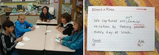 An example scrambled sentence index card from the activity. Like GPS occultations, analysis of distorted messages tells us where the sentences (signals) have been.Copyright (left) 2011 Jonah Kisesi, ITL Program, College of Engineering, University of Colorado Boulder, and (right) 2012 Denise W. Carlson, College of Engineering, University of Colorado Boulder
Each index card has a message and two tracking sections to help keep track of the changes made to the message. The "count" category signifies how long it would have taken for the signal to be sent from the GPS satellite to the LEO satellite had perfect weather existed for communication, thus allowing for the signal to travel directly to the LEO satellite. The "add" category represents how long it actually took for the signal to travel between the satellites due to delay-inducing events such as storms that slow the signal down and increase its bending.
Note: The two sections are named "count" and "add" because in the count section, students just count up by ones, whereas in the add section, they add numbers depending on which category they are assigned. The categories are explained later in this section. However, if you would like to more closely relate the "count" and "add" sections to occultations, rename them "direct" and "bent," since the count signal would travel directly (in a straight line) to the satellite as if the Earth was not in the way, while the add side represents the actual signal that bends around the planet before reaching the LEO satellite.
At game end, the instructor picks up the cards from the transmitters and reads aloud to the class the resulting messages, which often turn out to be quite amusing. Comparing the original messages to the received messages is helpful in determining the level of disturbance that occurred upon the signal. This is akin to knowing what the received GPS signal should look like compared to the actual received signal. Engineers use geometry, timing and other advanced techniques such as tomography to determine the location of these disturbances around the Earth.
In order to correctly represent the concept of occultations to students, make sure they clearly understand the game rules. The most important rules are:
- Know how many changes your assigned disturbance category makes on each card.
- Make the correct number of tally marks under the "count" and "add" sections on each card.
- Transmitters make sure not to pass on a card once it reaches them (otherwise messages end up being so distorted that no humor is in the results).
Before the Activity
- Of the two index cards each student receives, one is blank, and the other states the student's assigned disturbance classification. Prepare the disturbance cards by making about 60% 1D, 30% 2D, and 10% 0D. These categories indicate the number of changes (disturbances) students are to make to the cards that pass by them. A 0D makes no changes, a 1D makes one change, and a 2D causes two disturbances. A "change" means the student either crosses out or adds a word. For example, crossing out a word and replacing it with another word counts as two changes. Alternatively, you can entirely omit 0Ds so every student has the opportunity to make message changes. If you do this, make the split 70% 1D and 30% 2D.
- Write Table 1 on the board so the students can reference it throughout the game.
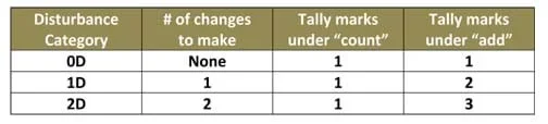 Table 1. Disturbance categories for the activity.
With the Students
- Have students prepare their blank index cards (see the template in Figure 2), writing their names at the top and "count" and "add" in the lower two corners, leaving space underneath for tally marks. It may help to draw the template card on the classroom board, or show an example using an overhead projector. Have students start to think about a 10-word (or more, preferably no longer than 16 words) sentence.
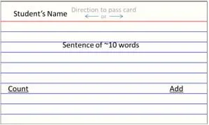 Figure 2. Example index card for students to prepare.
 - Explain the disturbance classifications in Table 1 and the significance of the "count" and "add" tracking sections.
- Your disturbance classification indicates the number of changes (disturbances) you are permitted to make to a card. A 0D makes no changes, a 1D makes one change, and a 2D causes two disturbances. A "change" means you can either cross out or add a word. For example, crossing out a word and replacing it with another word counts as two changes
- The count and add sections help us track how many changes a signal goes through. The count section tells us how many students the card was passed across between the sender and the receiver. The add section keep track of the number of changes that took place as the message was passed along. No matter what your disturbance category (refer to Table 1), you will always make one tally mark under "count" when it is your turn with a card. Also depending on your assigned disturbance category, you will make one, two or three marks under "add."
- Run through an example round with the students.
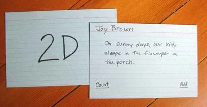 Example student index cards. One indicates the disturbance category. The other contains a message and tracking sections.Copyright 2012 Denise W. Carlson, College of Engineering, University of Colorado Boulder
- A transmitter is the person who sends the message; this person also acts as the receiver, where the message stops. Everyone else acts as the atmosphere between.
- Start with the teacher as the transmitter. Write a 10-word (or longer) sentence on an index card.
- Choose three students sitting next to each other. Give each student a disturbance category card.
- Hand the message card to the first student and have him make his changes. A change means the student either crosses out a word, or adds a word. If a student is a 2D, he either adds two words, cross out two words, or crosses out one word and adds another word. If a student is a 1D, he can only cross out one word or add one word, but not both. A 0D can make no changes to the sentence. Then, the student adds tally marks under the count and add sections (refer to Table 1). When crossing out a word, instruct students to make a line through the word, so that it can still be read.
- When the student is done, review the card with the class to make sure that the student made the right number of changes according to his classification and correctly added his tally marks to the "count" and "add" sections. It is helpful to show the card on an overhead projector so everyone can see.
- Repeat the previous step with the second and third students, stopping each time to verify the card changes and notations as a class.
- After the third student has made her changes, have her return the card to the teacher who makes changes based on his/her disturbance category. Point out that as the transmitter, you (the teacher) did not make any changes—you only passed on the card to get the signal started—but when receiving the card, you did make changes.
- Show that the total number of changes matches the difference between the add section and the count section.
- Give students a few minutes to come up with sentences about 10 words long and write them on their index cards. Remind them that their sentences must be school appropriate.
- Gather all the students' message cards. Use this time to quickly scan each sentence to make sure it is appropriate.
- Divide the class into groups of four or five students each. Assign one student in the group to be the transmitter/receiver. Have each group sit in a circle at a table or a cluster of desks, or on the floor. Remind students that the transmitter student serves as the GPS satellites (transmitting source) and LEO satellites (receiving source), and the other students represent the atmosphere. (Thus, transmitters also serve as receivers.)
- Randomly, pass out the disturbance category cards (with 0D, 1D or 2D written on them), one per student (including transmitters).
- As a reminder, ask students to tell you what constitutes a "change," and how many changes each disturbance category is permitted to make to a message (refer to Table 1).
- What kind of atmospheric activity (or more simply, weather) do we expect to result in a 0D disturbance? (Answer: 0D = no disturbance = clear skies.) What about 1D or 2D disturbances? (Answer: 1D = moderate disturbances = overcast, rain, light snow; 2D = significant or severe disturbances = thunderstorm, blizzard.)
- Verify that students understand how many tally marks to make under the "count" and "add" tracking sections (refer to Table 1).
- Give one message card (index card with a student-made sentence written on it) to each transmitter.
- Tell the transmitters to mark the cards with an arrow to the left or right and pass them in that direction without making any changes since they are the message sources. Remind transmitters that once cards reach them, they can modify them but they do not pass them on; they hold onto them until the end of the game when the teacher picks up all messages from the transmitters (so, each student in a group gets to change a card only once). Also, they do not pass cards to other groups; it is best to keep the cards within the small groups of 4-5 students.
- Once a transmitter passes a message card to a student, that student makes any changes (adds a word or crosses out a word, depending on his/her disturbance category) to the message passed to him/her, makes tally marks in the tracking sections (according to his/her disturbance category), and gives it to the next student. Remind students to cross out words by making one horizontal line through the words, so that they can still be read.
- After each group has started on a message, give each transmitter another message card on which to add an arrow and pass to a student (switch the direction the card is passed from the previous round so that more students are engaged simultaneously). Continue doing this until all message cards have been "sent."
- When ~15 minutes are left in the period, wait for all messages to reach the transmitters. Then have all the transmitters/receivers give you all the scrambled messages and ask one student to collect all the disturbance category cards.
- Read out the scrambled messages to the class. (Scan them first to be sure they are class appropriate.) If available, use an overhead projector to show the message cards, so students can read along and see the changes that occurred to the original message. If the instructor is willing, read each crossed out word as a static-y "chhhhh" sound.
- Examine the tracking sections with the class to find out how many changes (delays) occurred as the messages (signals) travelled across students (atmosphere) between transmitters/receivers (satellites). Tell them that a 0D represents clear skies, a 1D may be some rain, and a 2D could be taken as a thunderstorm or snowstorm.
- Continue the discussion with students to make the real-world connection. Make sure students realize that GPS satellites do send messages that are received by other satellites and people on the ground, however, they are not simple sentences, but rather are a series of 0s and 1s that form binary code that is deciphered in order to obtain useful information. So, having words added or scratched out on the sentences in this activity represents having incorrect (added), or missing (scratched out) data that distorts the original code sent by satellites.
- gps
- Acronym for global positioning system. A satellite constellation consisting of a minimum of 24 satellites orbiting Earth at altitudes of 20,000 km. They are commonly used by citizens for navigation purposes.
- leo
- Acronym for low-Earth orbit. Satellites in orbits up to 2,000 km above the Earth's surface
- occultation
- An event in which a GPS signal is bent as it passes through the Earth's atmosphere and is received by a LEO satellite. More generally: The act of blocking or hiding from view, as in an eclipse.
- tomography
- Imaging by sections using a penetrating wave (signal). For example, if you used sonar to take data of what is straight ahead of you (two dimensional) while moving to your side a few inches between measurements (sectioning), you can combine the measurements to form a three-dimensional model of what was in front of you as you moved sideways from your start to end point.
Pre-Activity Assessment
Review: Orally quiz students on content from the associated lesson to ensure mastery of the content at game start.
Activity Embedded Assessment
On Track: Watch to see that students are correctly completing the game. Continually ask various students what they represent in this activity, as well as what their disturbance cards represent.
Post-Activity Assessment
Reflection: Ask the following questions to the students as a class discussion, or have students answer them in small groups and report back to the class.
- How do engineers use GPS to study the weather? (Answer: Engineers create satellites and satellite control systems that maneuver the satellites to orbit the Earth and send, receive and collect GPS signals, which are analyzed to figure out the atmospheric conditions that caused the transmissions to be delayed and altered. The systems measure the bending and slowing of signals (occultations) as they pass through the Earth's atmosphere. By precisely measuring, to a few trillionths of a second, the time delays from this bending, they can infer information on atmospheric conditions such as air density, temperature, moisture, refractivity, pressure and electron density. This makes GPS radio occultation a powerful tool for weather and climate forecasting and space weather research. The captured satellite data is distribute to weather and climate forecasters who monitor ocean-born storms and phenomena such as El Niño/La Niña and global sea-level changes.)
- What are some advantages to using radio GPS occultation? (Answer: GPS occultation can probe with extreme precision the Earth's atmosphere from the Earth's surface to the top of the stratosphere [50 km/30 mi up]. It can operate in all weather conditions, penetrating the thickest clouds, and is relatively inexpensive. GPS receivers, comparable in size and complexity to notebook computers, can be built for a fraction of the cost of traditional space borne sensors and placed unobtrusively on many low-orbiting spacecraft.)
- Typically, would you expect more delay between satellites that are close to one another or satellites farther apart? (Answer: Farther apart.)
Explain It to a Relative: Imagine that you are an engineer studying occultations. Now, imagine that the person next to you is one of your cousins. S/he is curious about working with occultations, too. Explain to him/her how an occultation works. Then, repeat and switch to act as the listening cousin for a different student. (Example simple explanation: In GPS occultations, analysis of distorted messages tells us where the signals have been.)
- Remind students to write school-appropriate sentences on their message index cards.
- Make sure that message changes made by students do not result in inappropriate phrases.
The significance of the tracking sections ("count" and "add") is important; take time to explain these clearly so students know how to mark them.
Divide the class into groups of four or five students each. Tell them they are at a conference giving a presentation on occultations. Inform them that they have one minute to give their presentations to the class. Give them 5-10 minutes to prepare. Require that each person in the group speak an equal amount of time. Suggest they prepare brief notes (a script) for each speaker. They can also try to act out how an occultation works as the background to the speaker. Suggest that students incorporate into their presentations what they learned in this game/activity as well as what they learned from the associated Gathering Global Data: Mind Bending GPS Occultations lesson. To help them recall the lesson, give each group a copy of the lesson's GPS Occultations Worksheet Answers (PDF).
- For lower grades, eliminate the tracking sections as they may be too difficult for students to comprehend. But, be sure to speak to them about how we can use delays to help determine the causes of disturbances.
- For upper grades, while in their small groups, give each group a few scrambled index cards to analyze themselves. Have each group select two of their favorites to share with the rest of the class, while explaining how the message was changed and how much delay occurred. Ask students to think of phenomena other than weather that might affect signals (Possible answers: ionospheric [electron/charged] activity, solar activity, magnetic [polar] activity).
"Jason-2 Satellite Data to Help NOAA Track Global Sea Level." Posted May 20, 2008. NOAA, US Department of Commerce. The Jason-2/Ocean Surface Topography Mission (OSTM) satellite monitors the rate of sea-level rise and helps measure the strength of hurricanes. http://www.noaanews.noaa.gov/stories2008/20080520_jason.html
COSMIC Visuals and Multimedia Gallery. Visuals illustrating December 11, 2006 news release. Innovative Satellite System Proves Its Worth with Better Weather Forecasts, Climate Data. University Corporation for Atmospheric Research, National Center for Atmospheric Research, Boulder, CO. Accessed April 4, 2012. http://www2.ucar.edu/news/cosmic-visuals-multimedia-gallery
Purveyors of the Cosmic "Occult." Last updated November 30, 2006. Jet Propulsion Laboratory, NASA, Pasadena, CA. Accessed April 4, 2012 http://www.nasa.gov/vision/earth/lookingatearth/cosmicf-20061130.html
- Gathering Global Data: Mind Bending GPS Occultations
- GPS Satellite Data: Distorted Disturbances Game
Contributors
Jonah Kisesi; Penina Axelrad; Marissa H. Forbes
Supporting Program
Integrated Teaching and Learning Program, College of Engineering, University of Colorado Boulder
Acknowledgements
The contents of this digital library curriculum were developed under grants from the Fund for the Improvement of Postsecondary Education (FIPSE), U.S. Department of Education and National Science Foundation (GK-12 grant no. 0338326). However, these contents do not necessarily represent the policies of the Department of Education or National Science Foundation, and you should not assume endorsement by the federal government.
Copyright
2011 by Regents of the University of Colorado