
Gathering Global Data: Mind Bending GPS Occultations
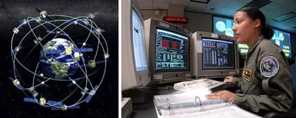 The GPS system is used for more than finding your way around a new city. By analyzing the signals sent and received by GPS satellites we can continuously examine the Earth's dynamic atmosphere for a wide range of purposes, including weather forecasting and climate change monitoring.Copyright (left) NIST and (right) Mike Meares, US Air Force, Wikipedia http://www.nist.gov/pml/div688/grp40/gpsarchive.cfm http://en.wikipedia.org/wiki/File:2_SOPS_space_systems_operator_040205-F-0000C-001.jpg
Students learn about the remote sensing radio occultation technique and how engineers use it with GPS satellites to monitor and study the Earth's atmospheric activity. Students may be familiar with some everyday uses of GPS, but not as familiar with how GPS technology contributes to our ongoing need for great amounts of ever-changing global atmospheric data for accurate weather forecasting, storm tracking and climate change monitoring. GPS occultations are when GPS signals sent from one satellite to another are altered (delayed, refracted) by the atmosphere passed though, such that they can be analyzed to remotely learn about the planet's atmospheric conditions.
Engineers and scientists use GPS satellites and low-Earth orbit (LEO) satellites to study the atmosphere of Earth, which provides information that is helpful in the analysis of weather, climate, pollution, ozone and solar radiation. Although GPS satellites designed by engineers are most commonly used for navigation, a technique called GPS occultations is now extensively used gather atmospheric data from all over the planet. Using satellite information gathered via this technique enables us to learn more about our weather and climate and how the atmospheric layers function and interact with one another.
After this lesson, students should be able to:
- Describe how disturbed GPS signals are analyzed in order to understand the type of weather they passed through.
- Compare actual results to expected results to find out reasons for any differences.
- Describe how GPS satellites are used for more than just navigation, specifically for natural disasters and other atmospheric phenomena.
- Weather is a result of complex interactions of Earth's atmosphere, land and water, that are driven by energy from the sun, and can be predicted and described through complex models
Grade 8
Do you agree with this alignment? - Weather conditions change because of the uneven heating of Earth's surface by the Sun's energy. Weather changes are measured by differences in temperature, air pressure, wind and water in the atmosphere and type of precipitation
Grade 5
Do you agree with this alignment?
- STEL-3D Explain how various relationships can exist between technology and engineering and other content areas.
Grades 3-5
Do you agree with this alignment? - STEL-3F Apply a product, system, or process developed for one setting to another setting.
Grades 6-8
Do you agree with this alignment?
- MS-ESS3-2 Analyze and interpret data on natural hazards to forecast future catastrophic events and inform the development of technologies to mitigate their effects.
Grades 6-8
This resource focuses on the following Three Dimensional Learning aspects of NGSS:
Science & Engineering Practices- Construct an oral and written argument supported by empirical evidence and scientific reasoning to support or refute an explanation or a model for a phenomenon or a solution to a problem.Do you agree with this alignment?
Disciplinary Core Ideas- Mapping the history of natural hazards in a region, combined with an understanding of related geologic forces can help forecast the locations and likelihoods of future events.Do you agree with this alignment?
Crosscutting Concepts- The uses of technologies and any limitations on their use are driven by individual or societal needs, desires, and values; by the findings of scientific research; and by differences in such factors as climate, natural resources, and economic conditions. Thus technology use varies from region to region and over time.Do you agree with this alignment?
- Graphs, charts, and images can be used to identify patterns in data.Do you agree with this alignment?
Do you agree with this alignment? - Construct an oral and written argument supported by empirical evidence and scientific reasoning to support or refute an explanation or a model for a phenomenon or a solution to a problem.
Radio occultation is a remote sensing technique used to measure the physical properties of a planet's atmosphere. It relies on the detection of a change in a radio signal (such as refraction/bending) as it passes through the planet's atmosphere (as it is occulted by the atmosphere).
Using GPS satellites to perform radio occultations is known as GPS occultations, and is a technique first applied in the mid-1990s for performing atmospheric measurements. An occultation event occurs when a GPS signal passes through the atmosphere and is received by a low-Earth orbit (LEO) satellite. As the signal passes through the atmosphere, it might be disturbed by events such as weather (temperature, humidity, water vapor concentration), causing the signal itself to be delayed and bent (refracted). By analyzing the received signal, an almost instantaneous depiction of the atmospheric state (the type of disturbances) can be determined, as well as its location. The technique provides information about activity taking place in the atmosphere between the GPS satellite and the receiver acquiring the GPS signal.
Typically, the receiving satellite is in a low-Earth orbit. For example, the COSMIC satellite constellation managed by the University Corporation for Atmospheric Research (UCAR) is a group of six satellites orbiting ~800 km above the Earth that receive and analyze GPS signals for occultation research. COSMIC stands for "constellation observing system for meteorology, ionosphere and climate." So, the occultation technique uses satellites orbiting a few hundred kilometers above us in combination with GPS satellites, which are 20,000 km above us (more than one and a half times the diameter of Earth!), to study what is going on in the air right above us.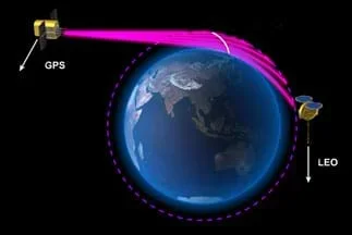 Figure 3. Progression of a GPS occultation. GPS signals pass through the atmosphere, are delayed and distorted due to gravity and atmospheric conditions, and are received by low-Earth orbit (LEO) satellites. Analysis of the received signal conveys the atmospheric state and location.Copyright University Corporation for Atmospheric Research http://www.cosmic.ucar.edu/launch/GPS_RO_cartoon.jpg
When a GPS signal passes through the atmosphere, it bends because of gravity and from refraction by more "turbulent" particles in the atmosphere not present in outer space (as shown in Figure 3). The more bending that takes place in a signal path signifies greater disturbance due to weather or other phenomena in the ionosphere or solar/magnetic activity. Generally, the lower a signal passes in our atmosphere, the greater the bending as the atmosphere is more pronounced closer to the ground than closer to outer space. These disturbances can distort the signal, scrambling the information received at the LEO satellite. Additionally, the more bending that takes places upon a signal, the longer its path to the receiver, meaning the message has been delayed and is received later than if it had travelled a straighter path.
Engineers analyze the signal delays and message distortions to determine the types of disturbances that took place along the signal paths. They also use satellite geometry, timing and other advanced techniques to localize the disturbing phenomenon by longitude, latitude and altitude. Because the relative position between the sending and receiving satellites changes over time, this technique allows for vertical scanning of successive layers of the atmosphere, making it helpful for weather forecasting tools and monitoring climate change. Systems like COSMIC can boost the accuracy of forecasts of hurricane behavior, significantly improve long-range weather forecasts, and monitor climate change with unprecedented accuracy.
GPS occultations are advantageous because they provide data from all over the globe. Because satellites are orbiting Earth, the various satellite positions allow for occultation event data to be obtained everywhere. Currently, COSMIC is able to obtain more than 2,000+ unique occultation events per day (see Figure 1). Each event lasts from a few seconds to a few minutes, but in this short time, much information is learned about what was going on in the atmosphere where the event took place. In contrast, to do this from the ground would require so many ground stations and staff to manage the equipment and data, which would add up to be very costly over time. Satellites are expensive to build and launch, but once in orbit, Earth's gravity keeps them in place and, in most cases, only small adjustments are needed to preserve the orbit integrity.
What do we use GPS satellites for? (Expect answers that deal with land, sea and air navigation.) Besides these, have you heard of any other uses for GPS? The global positioning system (GPS) was originally created by engineers for military use, but today, most people use it to help them find out where they are so that GPS receivers can direct them to desired locations. However, GPS is also used for land surveying, farming, fishing, tracking plate tectonics, time keeping, and atmospheric studies.
Today, we will focus on how to use GPS signals to study our atmosphere. Recall that as the Earth's atmosphere stretches from the ground up towards outer space, it is composed of many layers. How do we study our atmosphere? (Possible answers: Radar, weather stations, weather balloons, thermometers, barometers, satellites.) How do we use satellites to study our atmosphere? Well, satellites take images of our planet from which we get information about wind currents, smoke, clouds and storms, and other activity. We can also use signal analysis techniques, such as occultations, to send signals through the atmosphere and gain information by examining the different effects the atmosphere had on the signals.
Without satellites, if you want to be able to study weather and climate around the globe, you would need to have people and equipment at every location. Fortunately, satellites in various orbits around the Earth pass over all sorts of locations so we can gather information from those regions without having to send people or build weather stations in those areas. Even though designing, building and launching satellites are expensive, in the long term, they are less-expensive than the costs to position equipment and staff to acquire data from thousands of locations over the course of every day (see Figure 1). Unlike weather balloons and land-based data stations, the signals can penetrate clouds, portray multiple layers of the atmosphere and fill in the data gap over the oceans.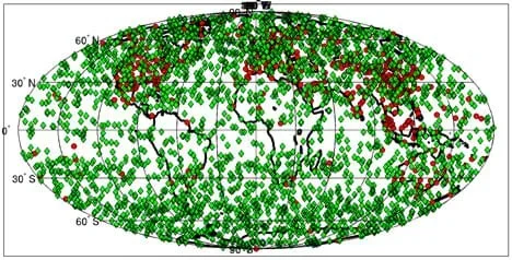 Figure 1. A typical example of the great amount of GPS occultation system data received in one day. Compare the amount of data from COSMIC GPS occultation locations (green diamonds) to that from weather balloons (red dots).Copyright Bill Schreiner, UCAR http://www2.ucar.edu/news/cosmic-visuals-multimedia-gallery
A technique called radio occultation is used with satellites to provide information about our atmosphere. For several decades, radio occultations have been used as a remote sensing technique. In fact, they were first used in interplanetary spacecraft to gather information about other planets in our solar system.
Remote sensing describes any way of making measurements or receiving information about objects, phenomena or locations, without making physical contact with the targets. More than 10 years ago, scientists and engineers started using GPS signals to study our planet's atmosphere using a new science called GPS occultations.
This technology provides the opportunity to mitigate natural hazards by providing temporally and spatially detailed data on storms, such as Hurricane Sandy – a hurricane in 2012 that was the second-costliest hurricane in United States history. [Show this video from UCAR of 2012 "Super Storm" Sandy (http://www.cosmic.ucar.edu/movies/sandy_cII.mov) to the class and ask the following questions]. What is this animation showing? [Answer: This is comparing data from different points between COSMIC (GPS) and NCEP along Sandy's path up the eastern US. It is important to explain to the class that NCEP data is data smoothed from ground observations.] What do you notice about COSMIC data versus NCEP? [Answer: They compare very well! This means that COSMIC data is providing accurate measurements that are consistent with other sources of atmospheric data.] Figure 2 shows actual atmospheric data (e.g. temperature and water vapor pressure) received from COSMIC.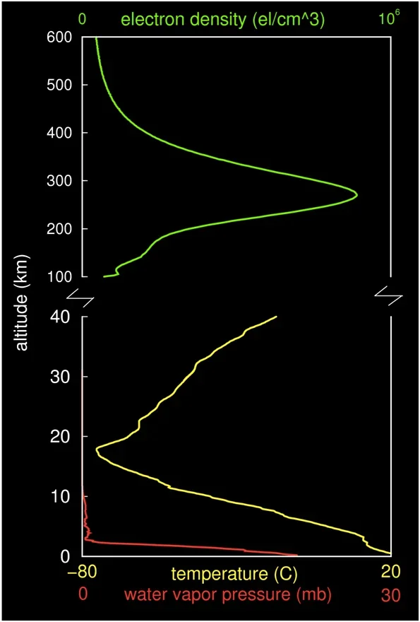 Figure 2. Temperature and water vapor pressure for various atmospheric depths at a given point during a given time.
(Continue presenting students with the information provided in the Lesson Background section. Then have students complete the attached worksheet before conducting the associated activity, GPS Satellite Data: Distorted Disturbances Game).
- cosmic
- Acronym for constellation observing system for meteorology, ionosphere and climate. Six satellites orbiting Earth that collect information that helps researchers advance our knowledge of the Earth's atmosphere.
- gps
- Acronym for global positioning system. A satellite constellation consisting of a minimum of 24 satellites orbiting Earth at altitudes of 20,000 km. They are commonly used by citizens for navigation purposes.
- gps radio occultation
- An event in which a GPS signal is bent as it passes through the Earth's atmosphere and is received by a LEO satellite. An occultation typically lasts from seconds to a few minutes. Analysis of the received signal indicates the atmospheric state passed through.
- interplanetary spacecraft
- A spacecraft launched out of the Earth's gravity field in order to travel to other planets to complete its mission.
- ionosphere
- Part of the Earth's upper atmosphere (80km–400km) consisting of several ionized layers due to solar radiation.
- leo
- Acronym for low-Earth orbit. Satellites in orbits up to 2,000 km above the Earth's surface
- occultation
- An event in which a GPS signal is bent as it passes through the Earth's atmosphere and is received by a LEO satellite. More generally: The act of blocking or hiding from view, as in an eclipse.
- radio occultation
- A remote sensing technique used to measure the physical properties of a planet's atmosphere. It relies on the detection of a change in a radio signal as it passes through the planet's atmosphere (as it is occulted by the atmosphere). For example, when electromagnetic radiation passes through the atmosphere, it is refracted.
- remote sensing
- Any way of making measurements or receiving information about objects, phenomena or locations, without making physical contact with the targets.
- tomography
- Imaging by sections using a penetrating wave (signal). For example, if you used sonar to take data of what is straight ahead of you (two dimensional) while moving to your side a few inches between measurements (sectioning), you can combine the measurements to form a three-dimensional model of what was in front of you as you moved sideways from your start to end point.
Lesson Summary Worksheet: Have students complete the GPS Occultations Worksheet (PDF), which includes nine fill-in-the-blank sentences and a word search puzzle. Review their answers to gauge their comprehension of the lesson content.
Refer students to Figure 2 and have them work in pairs to respond to the following questions:
- What is the range of temperatures that our atmosphere experienced on this particular day? [Answer: -80 to +20 degrees Celcius.]
- Convert your answer from Question #1 to a range of temperatures given in degrees Fahrenheit. Hint: The conversion from Celcius to Fahrenheit is: F = (5/9)*C + 32. [Answer: -12.4 to + 43.1 degrees Fahrenheit.]
- What happens to temperature as altitude increases? [Answer: Temperature decreases to about 18 km above the Earth's surface and then begins increasing with altitude thereafter.]
- The point at which temperature begins to increase with altitude is generally found at the beginning of the stratosphere. Hypothesize why there is a temperature inversion at this point. [Answer: This will likely be a difficult question for them to answer, but encourage students to be creative and think about what might cause a warming in that layer. The real answer has to do with ozone. 97% of the ozone found in the atmosphere is contained in the stratosphere. Ozone absorbs UV radiation which warms the stratosphere.]
- Make two observations about atmospheric water vapor pressure. [Answer: There is no water vapor pressure above 10 km. Water vapor pressure generally decreases with altitude. The decrease is not linear, in fact, water vapor pressure decreases steeply within the first 5 km and then stays relatively constant from 5-10 km above Earth's surface.]
COSMIC Visuals and Multimedia Gallery. Visuals illustrating December 11, 2006 news release: Innovative Satellite System Proves its Worth with Better Weather Forecasts, Climate Data. University Corporation for Atmospheric Research, National Center for Atmospheric Research, Boulder, CO. Accessed April 3, 2012. http://www2.ucar.edu/news/cosmic-visuals-multimedia-gallery
GPS Radio Occultation. Reference.com. Accessed April 3, 2012. http://www.reference.com/browse/GPS_Radio_occultation
Radio Occultation. Reference.com. Accessed April 3, 2012. http://www.reference.com/browse/Radio_occultation
- Gathering Global Data: Mind Bending GPS Occultations
Contributors
Jonah Kisesi; Penina Axelrad; Marissa H. Forbes
Supporting Program
Integrated Teaching and Learning Program, College of Engineering, University of Colorado Boulder
Acknowledgements
The contents of this digital library curriculum were developed under a grant from the Fund for the Improvement of Postsecondary Education (FIPSE), U.S. Department of Education and National Science Foundation GK-12 grant no. 0338326. However, these contents do not necessarily represent the policies of the Department of Education or National Science Foundation, and you should not assume endorsement by the federal government.
Copyright
2011 by Regents of the University of Colorado