
Geometry and Geocaching Using GIS & GPS
 An official geocache label that people affix to the hidden container to provide cache contact information.Copyright 2012 Lee Cannon, Flickr CC BY-SA 2
https://www.flickr.com/photos/leecannon/6924688841
An official geocache label that people affix to the hidden container to provide cache contact information.Copyright 2012 Lee Cannon, Flickr CC BY-SA 2
https://www.flickr.com/photos/leecannon/6924688841
Students take on the role of geographers and civil engineers and use a device enabled with the global positioning system (GPS) to locate geocache locations via a number of waypoints. Teams save their data points, upload them to geographic information systems (GIS) software, such as Google Earth, and create scale drawings of their explorations while solving problems of area, perimeter and rates. The activity is unique in its integration of technology for solving mathematical problems and asks students to relate GPS and GIS to engineering.
Students act as civil engineers, modeling a public works project. By working with GPS technology, students learn how engineers can mark locations with data and map that information using GIS software. Engineers use satellite imaging and GIS principals, and the activity demonstrates the broader use of these tools in engineering applications. Students also make connections to specific elements of mathematics that engineers may use, such as applying unit rates to determine how much material engineers need to complete a project.
After this activity, students should be able to:
- Use GPS technology to locate points given a latitude and longitude to determine locations on Earth and store those points digitally by transferring latitude and longitude data from a GPS to GIS (Google Earth).
- Solve problems involving scale drawings of geometric figures, including computing actual lengths and areas from a scale drawing and using appropriate tools such as a protractor.
- Explain how GPS and GIS relate to engineering.
- Solve problems related to angle measurements and angle relationships, such as complementary, supplementary and triangle and quadrilateral angle relations.
- CCSS.Math.Content.7.G.A Draw, construct, and describe geometrical figures and describe the relationships between them.
Grade 7
Do you agree with this alignment? - CCSS.Math.Content.7.G.A.1 Solve problems involving scale drawings of geometric figures, including computing actual lengths and areas from a scale drawing and reproducing a scale drawing at a different scale.
Grade 7
Do you agree with this alignment? - CCSS.Math.Content.7.NS.A.2 Apply and extend previous understandings of multiplication and division and of fractions to multiply and divide rational numbers.
Grade 7
Do you agree with this alignment? - CCSS.Math.Content.7.NS.A.3 Solve real-world and mathematical problems involving the four operations with rational numbers.
Grade 7
Do you agree with this alignment? - CCSS.Math.Practice.MP5 Use appropriate tools strategically.
Grades K-12
Do you agree with this alignment?
- Students will develop an understanding of the role of society in the development and use of technology.
Grades K-12
Do you agree with this alignment? - Technological systems can be connected to one another.
Grades 6-8
Do you agree with this alignment? - Students will develop an understanding of the core concepts of technology.
Grades K-12
Do you agree with this alignment? - Students will develop an understanding of the relationships among technologies and the connections between technology and other fields of study.
Grades K-12
Do you agree with this alignment?
- CCSS.Math.Content.7.G.A Draw, construct, and describe geometrical figures and describe the relationships between them.
Grade 7
Do you agree with this alignment? - CCSS.Math.Content.7.G.A.1 Solve problems involving scale drawings of geometric figures, including computing actual lengths and areas from a scale drawing and reproducing a scale drawing at a different scale.
Grade 7
Do you agree with this alignment? - CCSS.Math.Content.7.NS.A Apply and extend previous understandings of operations with fractions to add, subtract, multiply, and divide rational numbers.
Grade 7
Do you agree with this alignment? - CCSS.Math.Content.7.NS.A.3 Solve real-world and mathematical problems involving the four operations with rational numbers.
Grade 7
Do you agree with this alignment? - CCSS.Math.Practice.MP5 Use appropriate tools strategically.
Grades K-12
Do you agree with this alignment?
Each group needs:
- GPS-enabled device (most smartphones are equipped with GPS receivers)
- GPS app such as Free GPS (for Apple iOS) or Maverick: GPS Navigation or Handy GPS (for Android)
- computer or other device with an internet connection and Google Earth software installed (or the capability to install the software)
- Appendix A: Student Activity Handout (PDF)
- protractor
- ruler
For the class to share:
- small folders or plastic tubs to hold the contents of the geocache
- Appendix C: Problems for Geocaches (PDF)
- Appendix A: Student Activity Handout (docx)
- Appendix A: Student Activity Handout (pdf)
- Appendix B: Civil Engineering Calculation (docx)
- Appendix B: Civil Engineering Calculation (pdf)
- Appendix B Answer Key (docx)
- Appendix B Answer Key (pdf)
- Appendix C: Problems for Geocaches (docx)
- Appendix C: Problems for Geocaches (pdf)
- Appendix D: Group Members Latitude and Longitude Log (docx)
Ability to calculate area of various polygons, both regular and irregular. Ability to use a protractor and have a basic understanding of how a compass works. This activity is associated with the GIS, Mathematics and Engineering lesson.
 A word cloud of terms relating to GIS and GPS.Copyright 2012 Environmental Informatics Marburg, Flickr CC BY-NC-SA 2.0 https://www.flickr.com/photos/environmentalinformatics-marburg/8839279513
In the associated lesson, GIS, Mathematics and Engineering, you became familiar with GIS and GPS as well as some of the more practical mathematical and engineering applications associated with those systems. In today's activity, you will explore these technologies further by playing the hybrid role of civil engineers and geographers. You will use GIS and GPS devices to participate in a geocache hunt! These caches are located within a predefined space outside and your job is to navigate between them using GPS and math. Be prepared to do your own mapping while tracking your movements and viewing satellite images of your journey into geocaching! As part of this challenge, you will find a latitude and longitude on your GPS, mark waypoints, solve geometry and unit rate problems, upload GPS data to a GIS, and take on the role of engineers!
Civil engineering is primarily about designing infrastructure and making it sustainable for public use. Because engineers use an immense amount of information in planning infrastructure, GIS technologies provide them with tools to analyze and visualize these data. By playing the role of civil engineers, your task, on a smaller scale, is to help improve access to an area of public land. You will analyze information in order to design the perimeter of a new green space surrounded a fence that encloses all or part of the defined property.
Additionally, you will design a brick pathway within the fenced-in area and calculate the number of bricks necessary for the path. You will receive more information as we go over the instructions.
By the time you finish this challenge, you will: have transferred data from a GPS device to GIS software; tracked and located geocaches; created scale drawings of your journey; calculated the area within the boundaries of your exploration; and designed sidewalks and fences, all while taking into account materials through an engineering lens.
Background
Refer to the associated lesson, GIS, Mathematics and Engineering, for key contextual background and instruction on GPS, GIS, and waypoints.
Before the Activity
Note: this activity requires a substantial amount of setup; however, feel free to modify the procedure to fit your needs.
- Locate a large area (suggested minimum of a hectare, or 10,000m2) to set up the GPS activity. Soccer, baseball, and football fields suffice if no easy access to green space near the school is available, but a slightly larger area is required to follow the exact relative locations of waypoints laid out in the example provided. Modify the example to fit your constraints.
- Create your geocaches and label them with a name. Each geocache contains math problems, located in Appendix C: Problems for Geocaches (PDF), for students to solve for unknown angle values. After solving each problem, they follow the “solution” angle to find the next geocache and make a waypoint. Use a small receptacle (plastic tub, folder, etc.) for each geocache. The waypoints from each geocache, when put into Google Earth, form the shape of an irregular pentagon, with each geocache representing a vertex.
- The geocache problems in Appendix C: Problems for Geocaches (PDF) match the recommended irregular pentagon seen in Figure 1. Placing the geocaches in a slightly more irregular shape makes the activity more challenging; however, depending on the angle from which one geocache is located relative to another, you may need to make modifications to your math problems. To make the activity more realistic, choose an area with trees, taller grass, rocks, or other cover within which to conceal the geocaches. See below for more information about the geocaches.
- Plot your course using your GPS-enabled device and place your geocaches in the confines of your hectare area. Make sure the angle solutions located within each geocache correspond to the location of the next geocache (or geocaches). Also, choose a waypoint near geocaches from which each group can start. Later, upload these waypoints from the GPS device into Google Earth.
- Most smartphone-based GPS devices do not guarantee accuracy greater than 5 meters. With this in mind, aim to keep each geocache location as far away from each another as is reasonable, ideally no closer than 40 meters apart at a minimum. The margin for error in this activity is limited by the accuracy of the equipment as well as with Google Earth.
- Be sure to have enough GPS-enabled devices and corresponding computers to access the Google Earth program per group. (Download a free copy of Google Earth for the classroom computers.) As necessary, alter group size to accommodate the number of GPS devices in each class. Students may use either smartphones or dedicated GPS units, but the teacher needs to be able to troubleshoot and plan for each technology type. Ideally, find/borrow enough Apple and/or Android smartphones to use in the classroom; because this is the most likely scenario, the following tutorial uses those platforms.
- To start the activity, each group receives a waypoint (latitude/longitude) to input into their GPS device. For this reason, a larger polygon of five sides or more helps with group distribution around the activity zone. Try to spread the groups out amongst the geocaches as evenly as possible. To create a waypoint (or “placemark”) in Google Earth, simply click on the thumbtack icon in the top navigation bar, click and drag the tack to the desired location, and type in a name and notes. See Figure 1.
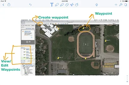 Figure 1. How to use waypoints in Google Earth.Copyright 2017 Jake Schell, University of Wyoming
- Share with each group the latitude and longitude waypoint it needs to start the GPS activity at its location. Have students complete Appendix D: Group Members Latitude and Longitude Log (PDF) with each group member’s name and starting latitude and longitude. In Google Earth, waypoints show up in the “Places” bar on the left-hand side of the screen. To edit, right click on the waypoint name in the map (or in the “Places” bar) and click on “Get Info.” See Figures 1, 2 and 3.
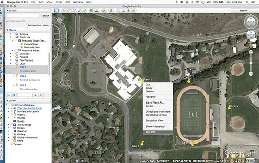 Figure 2. How to get data from Waypoints in Google Earth.Copyright 2017 Jake Schell, University of Wyoming
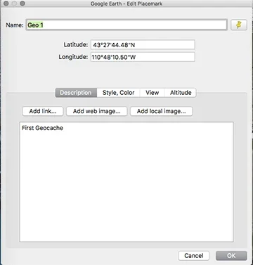 Figure 3. The “Get Info” dialogue box in Google Earth.Copyright 2017 Jake Schell, University of Wyoming
- Remember, if you do not set up your geocaches from this example, you must create word problems that result in angle measurements and distances for students to follow in order to move from geocache to geocache. For this reason, consider using the pentagon above and associated problems from Appendix C: Problems for Geocaches (PDF). An example of the activity’s flow by solving math problems and moving from location to location is as follows: Assume that a group is starting at the waypoint “Geo 1,” and you want them to proceed to the waypoint “Geo 2.” The problem provided at “Geo 1” needs to result in a solution of 90 degrees, because the group needs to move at a compass bearing of 90 degrees (or due east) to arrive at the next waypoint (assuming they were being asked to go in order). As an example, the question could read:
- Two angles are complementary. What is the sum of their angle measures?
- The area of a rectangle is 405 meters. The width of the rectangle is 3 meters. What is its length?
The answers to these questions (90 degrees and 135 meters, respectively) tell the students how far and in what direction to walk to the next geocache.
- Following the geocache activity, the students' focus shifts from one of GPS and GIS expert to that of civil engineers. The engineera are designing some brick walkways and a fence for part of the perimeter. The designs are limited to the shapes formed by the locations of each geocache location; however, following the example above, imagine the brick walkway forms a border around the perimeter of the rectangular section of the pentagon, with two paths crossing going east-west and north-south through the middle of the rectangle (see Appendix B Civil Engineering Calculation (PDF)). The walkway needs to be 2 meters wide and each brick covers 1/9 square meters. Students need to calculate how many bricks are required for engineers to complete the project. Based on the shape you create, alter the path size and shape to suit your needs. See Appendix B Answer Key (PDF) for a sketch of this scenario. You may want to create a shape for the fence or permit students to design a fence, which is a nice way to scaffold the activity. You may also alter the pathway and fence constraints if you so choose. For the example provided, the engineers are only fencing off the triangular portion to the east and are placing fence posts every 1 5/6 meters.
With the Students
Day 1
Part 1. Introduction:
- Hand out the Appendix A: Student Activity Handout (PDF), considering any necessary changes to fit your class/school, and arrange students in groups for the activity. Have students continue to refer to the activity handout through the duration of the activity.
- Read the Introduction/Motivation section with the class and provide background for the geocache activity.
- Go over the challenge/activity instructions.
Part 2. Navigating the Geocaches
- Refer students toward the latitude and longitude for their first geocache and navigate to new geocaches and GPS coordinates by solving math problems. Each student needs a pencil to work out the problems in the field. Each group starts at different locations, which will be Geocache 1 in their handouts.
- Hand out to each group the papers (from Appendix D Group Members Latitude and Longitude Log (PDF)) with the latitude and longitude of the geocaches.
- Direct students to copy down the latitude and longitude Geocache 1 in their student handout sheets. Direct students to look at the geocache locations in the handout and solve the two geometry problems located within each geocache. Space is provided to work out each problem. One answer tells the team what direction, such as an angle or compass bearing, to walk to find the next geocache, and the other answer provides the distance to travel in meters. Remind students any errors will keep them from finding the next geocache, so be mindful!
- Once a group finds the next hidden geocache location, they make a new waypoint in the GPS device and copy the geocache name as well as its latitude and longitude into the worksheet. Teams know they have finished when they arrive back at the location where they started. Once all the geocaches are found, have students return to class to work on Appendix A: Student Activity Handout (PDF).
Day 2
Part 3: Scaling Down
- In the second part of the activity, students assume the role of civil engineers. In this role, their supervisor wants to know the area that is contained by the geocaches so they can make improvements upon a parcel of public land. They also want to see a sketch of the area, to scale. So, students’ job is to calculate how much material they need for a few projects associated with this improvement project.
- Direct students to export the waypoints from your GPS device into Google Earth, just as they did in their activity.
- Draw a scale representation of the shape on graph paper. Find this in the student activity handout section titled Scaling Down. Have students calculate the area of the shape they created and include the scale and the distances represented by their drawing, since the objective is to make an accurate scale drawing of the perimeter created by their geocaches. Students can divide the area into polygons as a way to calculate their areas. Note that they are calculating the true area represented on the surface of the earth, not the area on the paper.
- Explain how to construct the sidewalk and fence areas. If you followed the example provided in the teacher preparation portion of this activity along with the Appendix B Answer Key (PDF), this is relatively simple. Again, this is a great place to provide extensions or scaffolding. Will students create their own fences and pathways, or will they follow a set design such as the one provided with the activity? Some students benefit from a set, guided pathway, while others can extend the lesson by designing their own. You may want to wait until you get back in from the field to convey this information.
Part 4: Activity Summary
To summarize, below is the outline of what the student engineers will be doing:
- We will go into the field and mark our geocaches with waypoints on the GPS. We will navigate between geocaches by answering the geometry questions contained within them, which will provide us with a distance and direction to walk to the next location.
- We will use the information above and our GPS units to find all of the geocaches.
- Acting as engineers, we will upload our waypoints into Google Earth, a GIS platform.
- We will draw a scale version of the track we made on graph paper in the handout.
- We will then calculate the area of earth contained within our track.
- We will design or draw a pathway through the area and a fence for all or part of the perimeter, calculating the necessary amount of materials to build these features.
- coordinate
- The combination of longitude and latitude, along with elevation, make a GPS coordinate which defines a single point on the surface of the earth.
- geographic information system
- A way to store, edit, and manipulate data or information, usually using maps; commonly referred to as GIS.
- global positioning system
- A satellite based navigation system that allows users to determine their position on the earth, among other uses; commonly referred to as GPS. More broadly, GPS can refer to any device used to locate a given position.
- latitude
- This represents an angle north or south of the equator, but is more easily understood as the y-coordinate of a location on the surface of the earth.
- longitude
- This represents an angle east or west of the prime meridian, but is more easily understood as the x-coordinate of a location on the surface of the earth.
- waypoint
- In the case of navigation, a fixed longitudinal and latitudinal coordinate or GPS point that identify a physical point.
Pre-Activity Assessment
Formative Assessment from Discussion: During the lesson and activity introductions, gauge the level of familiarity students have with the technology at hand. This informal assessment may generate data that helps you establish groups. A group of students with no GPS or little map experience could be at a significant disadvantage, so heterogeneous groupings based on familiarity with the topic are advisable.
Activity Embedded Assessment
Waypoint Checks: Groups proceed through the geocache by correctly answering geometry problems. Therefore, a check of their geocache GPS coordinates tells the teacher whether they were correctly solving the problems during the GPS activity. However, teachers could also take up student or group work from the geocaching portion to grade separately. Have teams take a screen shot of their group’s Google Earth screen after all GPS waypoints have been uploaded and prior to moving on to Step 2 of “Scaling Down.” Students can submit these images or just check them off.
Post-Activity Assessment
Activity Handout: Grade Part 2 (“Scaling Down”) from the Appendix A: Student Activity Handout (PDF). Grading Part 1 (“Navigating the Geocaches”) is optional. Review of their work lets you know if students understood the technical and problem-solving portions of the activity.
- It is recommended that you familiarize yourself with all technology in advance.
- In the event that the GPS does not send the information to the email account, either provide students with your own Google Earth Data, or have them work with another group’s data. Alternatively, have them manually input the latitude and longitude data into the waypoint through the “Get Info” tab after right clicking a waypoint (see Figures 2 and 3).
- If upon opening the KML file from the email Google Earth does not open the file, click and drag the file directly into Google Earth. Release the mouse pointer over the map to load the waypoints.
- If the app freezes or aborts, reset the device. On Apple devices, a hard reset may be required.
Any variety of extensions are possible, from creating different polygons to construction of different pathways or varying the engineering scope of the activity.
Have student groups research how civil, environmental, geophysical, and other engineers use GPS to monitor the motion of the earth. Possible applications for research include monitoring glacial growth and recession, plate tectonics, and landslides. Have teams create digital slide shows to present to the class.
Have students create their own shapes, fences, and walkway designs to solve for themselves or in groups.
- For lower grades, simplify the activity by providing students with directions and distances to travel between geocaches, or remove calculations for materials and eliminate some of the higher-level math.
- For higher grades, provide higher-level math content questions at each geocache, or model curved or traced paths from which students can build their paths.
Patton, K. The Fundamentals of GIS and Real World Application (PDF). Western Wyoming Community College.
Using Your iPhone & Google Earth for Plot Mapping (PDF). IR-4 Project, Department of Environmental
Toxicology, UC-Davis. http://wrir4.ucdavis.edu/Resources/Tricks/docs/GPSGoogleEarth%20Plot%20Mapping-iPhone.pdf.
Accessed September 25, 2018
GIS Solutions for Civil Engineering (PDF). ESRI. Accessed September 25, 2018. http://www.esri.com/library/brochures/pdfs/gis-sols-for-civil-engineering.pdf
- GIS, Mathematics and Engineering Integration
- Geometry and Geocaching Using GIS & GPS
- Topographic Maps and Ratios: A Study of Denali
Contributors
Jake Schell; Andrea Burrows
Supporting Program
University of Wyoming
Acknowledgements
This digital library curriculum was developed under the guidance of Andrea Burrows, Linda Hutchinson, and Michele Chamberlin at the University of Wyoming.
Copyright
2018 by Regents of the University of Colorado; original © 2017 University of Wyoming