
Watershed Balance
Students learn about the water cycle and its key components. First, they learn about the concept of a watershed and why it is important in the context of engineering hydrology. Then they learn how we can use the theory of conservation of mass to estimate the amount of water that enters a watershed (precipitation, groundwater flowing in) and exits a watershed (evaporation, runoff, groundwater out). Finally, students learn about runoff and how we visualize runoff in the form of hydrographs.
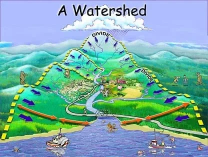 Figure 1. The boundaries of a watershed mark the location where all the water outlets into the same water source.Copyright Clark County, NV http://www.clarkcountynv.gov/Depts/water_quality/Pages/KidsCorner.aspx
Engineers must be able to understand, calculate and graph water runoff for many reasons, including flood control and management, water pumping, designing and building dams, recreational planning, and probability and statistics concerning future flood scenarios. These skills are particularly useful for civil engineers involved in modeling hydrological processes and studying water resource management for the benefit of human communities and natural ecosystems.
After this lesson, students should be able to:
- Describe the main components of the water cycle.
- Explain the types of data displayed in a runoff hydrograph.
- Calculate the regional water balance equation using conservation of mass.
- Estimate the amount of runoff leaving a watershed using the regional water balance equation.
- HS.3.1 Visual displays and summary statistics condense the information in data sets into usable knowledge.
Grades 9-12
Do you agree with this alignment?
- Develop, communicate, and justify an evidence-based scientific explanation showing how ecosystems follow the laws of conservation of matter and energy
Grades 9-12
Do you agree with this alignment? - Describe how carbon, nitrogen, phosphorus, and water cycles work
Grades 9-12
Do you agree with this alignment? - Develop, communicate, and justify an evidence-based scientific explanation addressing questions regarding the interaction of Earth's surface with water, air, gravity, and biological activity
Grades 9-12
Do you agree with this alignment?
- CCSS.Math.Content.HSA-REI.A.2 Solve simple rational and radical equations in one variable, and give examples showing how extraneous solutions may arise.
Grades 9-12
Do you agree with this alignment? - CCSS.Math.Content.HSN-Q.A.1 Use units as a way to understand problems and to guide the solution of multi-step problems; choose and interpret units consistently in formulas; choose and interpret the scale and the origin in graphs and data displays.
Grades 9-12
Do you agree with this alignment?
- STEL-4R Assess a technology that minimizes resource use and resulting waste to achieve a goal.
Grades 9-12
Do you agree with this alignment?
- HS-ESS2-5 Plan and conduct an investigation of the properties of water and its effects on Earth materials and surface processes.
Grades 9-12
This resource focuses on the following Three Dimensional Learning aspects of NGSS:
Science & Engineering Practices- Plan and conduct an investigation individually and collaboratively to produce data to serve as the basis for evidence, and in the design: decide on types, how much, and accuracy of data needed to produce reliable measurements and consider limitations on the precision of the data (e.g., number of trials, cost, risk, time), and refine the design accordingly.Do you agree with this alignment?
Disciplinary Core Ideas- The abundance of liquid water on Earth's surface and its unique combination of physical and chemical properties are central to the planet's dynamics. These properties include water's exceptional capacity to absorb, store, and release large amounts of energy, transmit sunlight, expand upon freezing, dissolve and transport materials, and lower the viscosities and melting points of rocks.Do you agree with this alignment?
Crosscutting Concepts- The functions and properties of natural and designed objects and systems can be inferred from their overall structure, the way their components are shaped and used, and the molecular substructures of its various materials.Do you agree with this alignment?
Do you agree with this alignment? - Plan and conduct an investigation individually and collaboratively to produce data to serve as the basis for evidence, and in the design: decide on types, how much, and accuracy of data needed to produce reliable measurements and consider limitations on the precision of the data (e.g., number of trials, cost, risk, time), and refine the design accordingly.
- HS-ETS1-1 Analyze a major global challenge to specify qualitative and quantitative criteria and constraints for solutions that account for societal needs and wants.
Grades 9-12
This resource focuses on the following Three Dimensional Learning aspects of NGSS:
Science & Engineering Practices- Analyze complex real-world problems by specifying criteria and constraints for successful solutions.Do you agree with this alignment?
Disciplinary Core Ideas- Criteria and constraints also include satisfying any requirements set by society, such as taking issues of risk mitigation into account, and they should be quantified to the extent possible and stated in such a way that one can tell if a given design meets them.Do you agree with this alignment?
- Humanity faces major global challenges today, such as the need for supplies of clean water and food or for energy sources that minimize pollution, which can be addressed through engineering. These global challenges also may have manifestations in local communities.Do you agree with this alignment?
Crosscutting Concepts- New technologies can have deep impacts on society and the environment, including some that were not anticipated. Analysis of costs and benefits is a critical aspect of decisions about technology.Do you agree with this alignment?
Do you agree with this alignment? - Analyze complex real-world problems by specifying criteria and constraints for successful solutions.
Hydrology is the study of water. The hydrological cycle is the movement of water through the planet's systems, that is, its atmosphere, land and oceans. This lesson introduce these concepts and some quantitative applications to these theories.
The hydrological cycle may be visualized in a few ways. Expect most students to have a general concept of how the water cycle is perpetuated by precipitation and evaporation, from which you can elaborate. Figure 2 is a simple visual that provides a more physical and descriptive image of the components in the water cycle; Figure 3 is a more abstract view. The Figure 3 flow chart of the cycle helps students think about the main storages of water (atmosphere, land and oceans) and how they are connected.
The flow chart view of the water cycle is also a way of thinking about inputs and outputs (Equation 1). Due to the principle of conservation of mass, we can track water through a system. For instance, if we know how much water went into a system and how much water left, then we can calculate/estimate how much is stored in the system. This approach is important for water resource engineering. For instance, being able to predict how much streamflow will occur in a given storm or season is an important consideration for anyone living or building structures in floodplains. Additionally, being able to estimate how much water is available as either surface or groundwater is important for water resource management. The math problems in the Assessment section provide a way for students to test these ideas.
The transfer of water along the land surface is called runoff. It is important for engineers to model and understand the runoff response of an area to a storm or snowmelt. Engineers answer questions such as:
- How soon after a storm will runoff reach a town downstream?
- How much water would it take to flood a streambed?
- How much water will be the peak streamflow response?
To investigate these situations, engineers create and analyze hydrographs—a type of graph that plots streamflow data. Annual hydrographs show how streamflow changes throughout the year. We typically see streamflow peaks in the spring and early summer months when warmer weather accelerates snow melt. Looking at many years of data, smaller streamflows at usually peak times can indicate drought years, when winter snowpack or rainfall was lighter than usual, impacting the downstream availability of water for drinking water, irrigation and recreation. Engineers also create and examine event hydrographs, which span a much shorter period of time than a year, often minutes or hours. Event hydrographs show stream response to certain level storms. If it rains for an hour and a stream gage (a monitoring instrument) collects data a mile downstream, an event hydrograph can be created by plotting the streams response to that storm at that gage point.
Today we are going to learn about the hydrological cycle. What is hydrology? (Answer: Hydrology is the scientific study of the distribution and quality of water on Earth.) We also call this the water cycle. Let's spend five minutes and do a think-pair-share. (Think-pair-share activities pose a question to students that they must consider alone and then discuss with a neighbor or two before settling on a final answer. Follow the group discussion "sharing" with a larger classroom discussion.) With a partner next to you, imagine a lone molecule of water in your backyard and think about where that molecule of water could go. Think of this scenario as you write down all the steps to the water cycle you can think of.
(After about five minutes.) Now, as a class, let's see if we can re-create the water cycle on the board. (On the classroom board, diagram the water cycle one of two ways, either similar to Figure 2 for beginner-level students, incorporating clouds, mountains, lakes, rivers, trees and other land features to help them visualize the real-world components of the water cycle, or similar to Figure 3 for more advanced students, which illustrates the water cycle in the form of a flow diagram, as a system of storages: atmosphere, land, oceans.) Looking at the water cycle, how does water move from the atmosphere to the ocean? (Answer: Precipitation.) How does water move from the oceans into the atmosphere? (Answer: Evaporation.) How does water move from land to the ocean? (Answer: Runoff or groundwater.)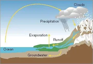 Figure 2. The main components of the Earth's water cycle.Copyright US Department of Energy http://www1.eere.energy.gov/tribalenergy/guide/hydropower_works.html
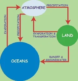 Figure 3. The water cycle diagrammed as a system of storages between the atmosphere, land and oceans.Copyright NASA http://spaceplace.nasa.gov/cloud-scramble/
Often in hydrology, we talk about the hydrology of a watershed. A watershed is an area or region that is drained by a common river system. (Show students the Figure 1 watershed, or a similar image). In this drawing (Figure 1), all of the water that falls within the yellow dashed lines theoretically drains through the same outlet point on the main river downstream.
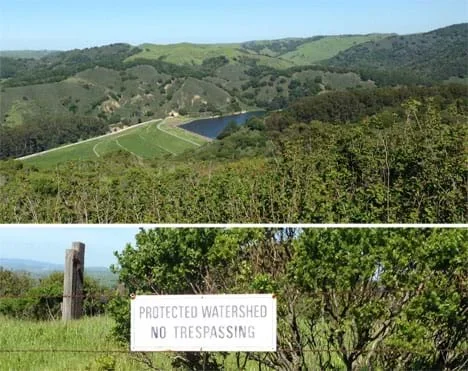 The San Pablo Creek watershed east of San Francisco, CA.Copyright 2016 Denise W. Carlson, ITL Program, College of Engineering, University of Colorado Boulder
Within our watershed, water exists as precipitation, surface water (or runoff), groundwater (below ground) and evaporation. Assuming our watershed is a closed system, we can apply the principle of conservation of mass to our watershed to come up with an equation that tracks how much water is in each of these storages. What is conservation of mass? (Answer: A fundamental theory stating that for any closed system, mass is conserved over time.) According to the conservation of mass:
What are the inputs of water into our watershed? (Answer: Precipitation and any groundwater flowing in.) What are the outputs? (Answer: Runoff, evaporation and any groundwater flowing out.) Let's substitute this information into Equation 1.
Where, P equals precipitation, GW equals groundwater, E equals evaporation, and Q equals runoff. Equation 2 is known as the regional water balance equation. (Essentially, Equation 2 is a more specific version of Equation 1, because it defines the types of water inputs and outputs in a system.) We can generally assume, based on the way we defined a watershed, that the groundwater change is negligible. Also, over very long time periods (greater than 10 years), we can also assume there is no storage in the system. Conveniently, this gives us a simplified way to estimate the amount of runoff we could expect given a certain amount of precipitation and evaporation.
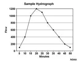 Figure 4. An example event hydrograph that occurs over a short period of time.Copyright GOES-R, NOAA via University Corporation of Atmospheric Research http://www.goes-r.gov/education/comet/hydro/basic/HydrologicCycle/print_version/04-surface_water.htm
After it rains, water can infiltrate into the ground and replenish our groundwater supply, or it can evaporate, returning to the atmosphere. Some amount of the water flows into rivers and streams and discharges into oceans or reservoirs. Do the different terrains surrounding rivers have an impact? Have students explore this idea with the fun and hands-on associated activity Floodplain Modeling. We call it runoff because it "runs off" the land. Most runoff starts in streams, flows into rivers and eventually empties into the ocean. Why is runoff important to a community? (Answers: For people to use as a drinking water source, irrigation source, etc.) Why is runoff important to plants and animals? (Answers: It keeps them alive and healthy. It provides habitat for aquatic freshwater organisms.) Why would estimating the amount of runoff be important for engineers? (Possible answers: For engineering purposes such as flood management, hydropower applications, dam design, water resource/supply management, etc.)
If it rains a lot, there will be a lot of runoff. If the amount of runoff is too much for a riverbed to carry, then water rises up over the riverbanks and creates a flood. Students can expand their understanding with the associated activity Flood Analysis where they graph real-world stream gage data to create different types of hydrographs and calculate flood frequency statistics.
We visualize runoff by using hydrographs. Think about the word hydrograph—what do you think this would look like? On a hydrograph, we keep time on the x-axis and streamflow on the y-axis. (Show students the example hydrographs in Figures 4 and 5.) Look as these examples of an event hydrograph and an annual hydrograph. An event hydrograph is for a single storm event, while an annual hydrograph plots streamflow over the course of a year or multiple years.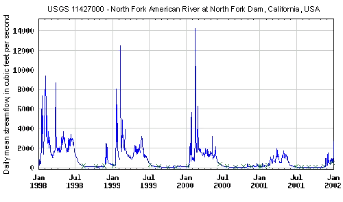 Figure 5. An example annual hydrograph. This chart shows the runoff (average streamflow for each day, in cfs) at a California dam gage station over four years.Copyright US Geological Survey http://ga.water.usgs.gov/edu/watercyclesnowmelt.html
Engineers must be able to understand, calculate and graph runoff for many reasons such as flood control and management, water pumping, designing and building dams, recreational planning, and probability and statistics concerning future flood scenarios. These skills are especially useful for civil engineers involved in modeling hydrological processes and studying water resource management. Following the lesson, students can act as engineers in the associated activity Protecting Our City with Levees to design, build and test model levees—barriers to prevent storm water from flooding a community.
- annual hydrograph
- A type of hydrograph that plots the annual or monthly streamflow.
- conservation of mass
- A theory that states that mass is neither created nor destroyed. We use the concept of conservation of mass to keep track of the water in a given closed system, such as a watershed.
- evaporation
- When water changes phase from liquid to gas and leaves the land surface.
- event hydrograph
- A type of hydrograph that plots the response to a specific rainfall event, spanning a length of time from minutes to days.
- groundwater
- Water that is naturally stored underground, beneath the surface of land, usually in the pores of soil and rock.
- hydrograph
- A graph showing the rate of flow (volume/time) versus time from data collected at a specific point in a river or stream.
- precipitation
- The input of water to a land surface from the atmosphere; may be in the form of rain, snow, hail, etc.
- storage
- In the context of hydrology, refers to different stages in the water cycle. For example, water is present in storages in the atmosphere, on land, or in the oceans.
- surface water
- The water that neither infiltrates nor evaporates from the land surface. Instead, it contributes to the supply of water on the surface in the form of rivers, lakes, wetlands and oceans. In hydrology, also known as runoff or discharge.
- watershed
- An area or region that is drained by a common river system.
Pre-Lesson Assessment
Pre-Quiz: Ascertain students' base understanding of the water cycle and hydrographs by asking them the following multiple-choice questions.
- Which of the following represents the movement of water from the oceans into the atmosphere? Choose from: (a) runoff, (b) precipitation, (c) evaporation. Answer: (c).
- Which of the following represents the movement of water from the land surface into the oceans? Choose from (a) runoff, (b) precipitation, (c) evaporation. Answer: (a).
- Which of the following represents the movement of water from the atmosphere to either the land surface or oceans? Choose from (a) runoff, (b) precipitation, (c) evaporation. Answer: (b).
- A hydrograph is: ________. Choose from: (a) an instrument used to measure streamflow, (b) a map of stream gage locations, (c) a graph that plots streamflow. Answer: (c).
Post-Introduction Assessment
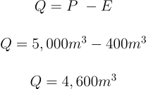
Real-World Calculations: See if students comprehend the application of the principle of conservation of mass to water resource engineering by assigning them to solve mathematically the following problems (or work through them together, as a class). In these problems, students use the regional water balance equation to estimate the amount of runoff leaving a watershed. By thinking of a watershed's water cycle as a closed system of inputs and outputs (inputs – outputs = storage), we (and engineers) can make water estimates and predictions.
- In a watershed that is 3.5 km2, the volume of annual precipitation was 5,000 m3 and the volume of water that was evaporated was 400 m3. Estimate the volume of annual runoff (m3). Assume that storage and groundwater flux are negligible. Answer:
- In a watershed that is 5 km2, annual precipitation was 20 cm and the evaporation rate was 0.01 cm/d. Estimate the volume of annual runoff (m3). Assume that storage and groundwater flux are negligible. Answer:

Lesson Summary Assessment
Discussion Questions: Before conducting the associated activity(ies), evaluate students' comprehension of the lesson concepts through a class discussion. Example questions:
- What are the primary components of the hydrological cycle (water cycle)? (Answer: Precipitation, runoff/surface water, groundwater, evaporation, transpiration between the planet's atmosphere, land and oceans.)
- How does water move from the oceans into the atmosphere? (Answer: Evaporation.)
- How does water move from the land surface into the oceans? (Answer: Surface water, runoff.)
- How does water move from the atmosphere to either the land surface or oceans? (Answer: Precipitation.)
- What is a watershed? What is a hydrograph? Define in your own words the lesson vocabulary words.
- What types of data are plotted to create a runoff hydrograph? (Answer: To make a hydrograph, we use surface water flow data collected at one location over a period of time. We plot the rate of flow in volume/time units, such as cubic feet per second, on the y-axis, over time, on the x-axis.)
- What is the difference between an event hydrograph and an annual hydrograph? (Answer: The difference is the time period, short data collection for a storm event, perhaps minutes or hours, versus long data collection, perhaps years.)
- What equations have we learned today and what do they describe? (Answer: We learned three equations: conservation of mass, the regional water balance equation, and a simplification to the regional water balance equation. Conservation of mass states that mass is conserved over time. The regional water balance equation is a closed water cycle system that considers inputs and outputs of water. One simplification we can make is to assume groundwater has negligible effects, thus we use precipitation and evaporation to estimate runoff.)
- What do we mean by the regional water balance equation? (Answer: It's the regional closed water cycle system in equation form: precipitation plus incoming groundwater minus the sum of leaving groundwater and runoff equals storage. It puts all together the inputs and outputs in the watershed "system.")
- How do engineers apply the principle of the conservation of mass to understand watersheds? (Answer: Engineers think of the watershed as one closed water cycle system, with inputs, outputs and storage amounts.)
- For what purposes might engineers collect a watershed's streamflow data, make hydrographs and use the regional water balance equation? (Example answers: To calculate a community's expected water needs [drinking water, sewage treatment, recreation, irrigation of crops, parks and yards], to recommend whether water restrictions should be put in place during droughts, to inform land owners of areas that are at risk of flooding, to design and manage dams and reservoirs, to determine probabilities and statistics about potential flood scenarios, etc.)
Extension Activity: Have your students use what they learned and apply it to a real-world engineering problem. Pose the following scenario to your students:
- Longmont, CO, is a town that sits at an elevation of ~5,000 ft above sea level to the east of the Rocky Mountains and north of Denver, CO. The St. Vrain Creek, which is a tributary of the South Platte River, flows right through the center of Longmont, CO. Starting on September 9, 2013, a weather system stalled over this area of Colorado and dropped almost 20 inches of rain over the following week. To put this in perspective, this area of Colorado generally sees 20 inches of rain over the course of an entire year. On September 12, streamflow reached 6,000 cubic feet per second! The resulting Colorado Flood of 2013 was one of the worst recorded natural disasters the state has ever seen. Imagine you are a Civil Engineer that works for the city of Longmont, CO and answer the following questions:
- Describe what the event hydrograph would look like for this event. [Answer: the event hydrograph would have an x-axis with time spanning from Sep 9 to Sep 16 and a y-axis spanning from 0 to 6,000 cfs.]
- Describe what the annual hydrograph that spanned January 2013 – December 2013 would look like. [Answer: this would follow the general shape of the hydrograph in Figure 5 (showing increased flow during the spring/summer months, however, in addition there would be a large peak during the Sept 9-12 period as compared to any other flows throughout the year.]
- As a Civil Engineer, you are tasked to develop ways for the city to be more prepared for a flooding scenario in order to protect its citizens. What are some ideas for protecting against future flooding? [Example ansers: (1) Fix the local floodplain map to make sure it is updated and to better ready citizens for evacuation plans, (2) Model the flow and capacity of stormwater drainage to make sure it can handle a catastrophic event, (3) Use a computer model that will use the flow of water upstream to estimate the flow of water at a point downstream so that we can have better emergency alert systems that eliminate 'flash" flood situations.]
- Watershed Balance
Contributors
Emily Gill; Malinda Schaefer Zarske
Supporting Program
Integrated Teaching and Learning Program, College of Engineering, University of Colorado Boulder
Acknowledgements
This digital library content was developed by the Integrated Teaching and Learning Program under National Science Foundation GK-12 grant no. DGE 0338326. However, these contents do not necessarily represent the policies of the National Science Foundation, and you should not assume endorsement by the federal government.
Copyright
2013 by Regents of the University of Colorado