
Floodplain Modeling
Students explore the impact of changing river volumes and different floodplain terrain in experimental trials with table top-sized riverbed models. The models are made using modeling clay in aluminum baking pans placed on a slight incline. Water added "upstream" at different flow rates and to different riverbed configurations simulates different potential flood conditions. Students study flood dynamics as they modify the riverbed with blockages or levees to simulate real-world scenarios.
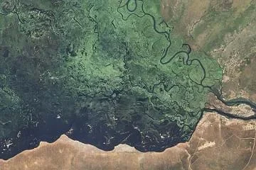 Students model floodplainsCopyright NASA Earth Observatory http://commons.wikimedia.org/wiki/File:Zambezi_Flood_Plain,_Namibia_(EO-1).jpg
To prevent property destruction and injury to people, engineers study the dynamics of floodplains. They collaborate with specialists in other fields to understand all contributing factors. Information on local weather and climate conditions, together with the river basin geography and geology become part of computer generated models to simulate combinations of conditions to see the impact on water level. What they learn is applied to the design of retention structures to control flood waters. Despite tremendous efforts, flood mitigation efforts do not always work. Throughout history, many have failed and resulted in disasters.
After this activity, students should be able to:
- Define floods as a natural phenomenon that occurs when too much water is in an area at one time.
- Describe the shape of a riverbed as a major factor in where flooding occurs.
- Explain that engineers use models and testing to understand how to design solutions.
- Explain that engineers help people identify and prepare for flooding, including the design of dams, levees and dikes to protect people and property when flooding occurs.
- Discuss how human modifications to a river may alter the floodplain of the river.
- Use evidence to model how water is transferred throughout the earth
Grade 6
Do you agree with this alignment? - Identify problems, and propose solutions related to water quality, circulation, and distribution – both locally and worldwide
Grade 6
Do you agree with this alignment?
- Models are used to communicate and test design ideas and processes.
Grades 3-5
Do you agree with this alignment? - STEL-3G Explain how knowledge gained from other content areas affects the development of technological products and systems.
Grades 6-8
Do you agree with this alignment?
- MS-ETS1-4 Develop a model to generate data for iterative testing and modification of a proposed object, tool, or process such that an optimal design can be achieved.
Grades 6-8
This resource focuses on the following Three Dimensional Learning aspects of NGSS:
Science & Engineering Practices- Develop a model to generate data to test ideas about designed systems, including those representing inputs and outputs.Do you agree with this alignment?
Disciplinary Core Ideas- Models of all kinds are important for testing solutions.Do you agree with this alignment?
- The iterative process of testing the most promising solutions and modifying what is proposed on the basis of the test results leads to greater refinement and ultimately to an optimal solution.Do you agree with this alignment?
Do you agree with this alignment? - Develop a model to generate data to test ideas about designed systems, including those representing inputs and outputs.
Each group needs:
- 2 sheets of cardstock (or paper) for construction of model houses (alternative: use math snap cubes as houses; they won't get ruined when wet and rinse off easily when finished; need at least 6 per group; won't need template, tape, scissors or markers)
- Model House Template (PDF)
- transparent tape
- scissors
- markers, colored pencils, or crayons to decorate houses
- 5-pound (2.3 kg) box of modeling clay per group (reusable)
- aluminum baking pan
- a small board (or something else rigid) to support the baking tin after inserting the clay
- clean-up supplies (paper towels, sponges, towels, etc.), for after using wet clay
- a thick book to prop up the plastic tub (may not be needed if you conduct activity outside)
- Riverbed Template (PDF), one of three designs provided
To share with the entire class:
- computer with projector to show students attached PowerPoint presentation (or print out some images from the presentation)
- computer with Internet access to show students video clips of actual river flooding
- 1 large, shallow, plastic waterproof tub (8-in x 14-in x 30-in or 20-cm x 36-cm x 76-cm, clear plastic is better but not necessary) (may not be necessary if you can conduct the activity outside)
- wire cutters or tin snips to cut the baking pan (only necessary first time) (alternative: use the plastic landform trays in FOSS Landforms kits, which are shaped like baking trays and have drain holes)
- a small paper cup, used to pour water over the riverbed model
Water, Water Everywhere lesson in the Natural Disasters unit. Other lessons in the Natural Disasters unit are also helpful.
(Kick-off the activity by showing students a few dramatic video clips of actual river floods washing away houses [exactly what they'll be simulating with their model riverbeds]. Many short videos are available on YouTube. See the Additional Multimedia Support section for suggestions.)
We are going to have some fun today and learn more about flooding by creating our own mini-floods. Scientists and engineers do these same types of experiments with small-scale models, as well as computer simulations, to understand how real-life floods behave. Using models to make observations and collect data allows engineers to develop effective designs. Does anyone know what a floodplain is? Well, it is the dry land surrounding a waterway, like a river or stream, into which flooding waters spill. An engineer needs to know the area of a floodplain in order to figure out a flood might affect anything located there and if a design solution needs to be implemented
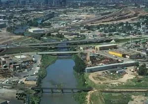 What happens when the floodplain of a populated area floods?Copyright National Park Service http://www.nps.gov/ncrc/portals/rivers/projpg/flood.htm.
We are going to build mini-houses (models), too, and see if they get wiped out by the flood. This brings up an interesting point. If the human-made buildings were not there, would the flooding be a problem? Probably not. Natural flooding has been occurring for thousands of years. It only becomes a problem when people create something of value in the floodplain, like houses, that might be destroyed in a flood. As it turns out, floodplains are very attractive locations to build towns and cities — until flooding occurs. Why do you think people build houses in floodplains? Well, a floodplain is usually a nice flat area conveniently located near a river that can be used for transportation, agriculture and recreation, and the land is usually good for growing crops because of the rich soil deposited by past floods.
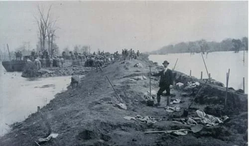 Repairing a Mississippi levee, 1903.Copyright Sean Linehan, NOAA http://www.photolib.noaa.gov/htmls/wea00764.htm
Today we are going to test a few different situations that cause flooding. What might cause a flood to happen? Well, there are a few considerations. The most important one is how much water is in the area. The more water that is introduced into an area (through rain or melting snow), the more likely flooding is to occur. Another important factor is how much space there is for the water to flow or settle into. If the riverbed is constricted or blocked by something like a dam or levee, then the water must find someplace else to go. Since floodplains are large areas, the water can spread out all over the place. Another issue (that is not addressed by this activity) is how much water the ground can absorb. Have you ever noticed that water soaks into the ground after it rains and makes the ground soggy or muddy? Well, different soils absorb different amounts of water, which can affect the amount of flooding that results. We are not going to look at that today, because we are using modeling clay, which absorbs essentially no water.
(Show students the attached PowerPoint presentation, Floods, Floodplains and Levees (PPT), to provide a visual understanding of floods, floodplains and levees. Or, print out some of the images to pass around class during the introductory discussion.)
Some engineers study flooding, using what they learn to protect people and property. They design structures — like dams, dikes and levees — to keep flooding away from populated areas. Today we are going to design a model of a floodplain, just like an engineer would do. We will also record our observations and data in order to better understand how to develop a design solution. Are you ready?
Before the Activity
- Gather materials and make copies of the Model House Template (PDF) and Riverbed Templates (PDF).
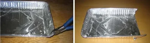 Figure 1. Prepare the riverbed model by cutting the baking pan at two corners and folding under the end flap.Copyright 2006 Tim Nicklas, ITL Program, College of Engineering, University of Colorado at Boulder
- The baking pan is the base for the riverbed and floodplain. Modify the pan to allow water to flow out of it. You can cut off one end of the baking pan, or cut two corners and fold the end flap under (see Figure 1), or just cut a drain hole at one end. Prepare three pans in this way, one for each student group.
- Pack the baking pans with modeling clay to a depth of ~1 cm (see Figure 2). To save time, do this step in advance. If time allows, have the students do it.
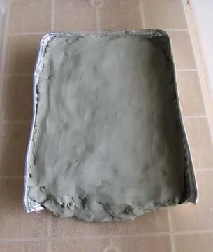 Figure 2. Pack the baking pan with clay.Copyright 2006 Tim Nicklas, ITL Program, College of Engineering, University of Colorado at Boulder
- To catch water runoff, place the baking pan inside a plastic tub. Use a thick book (dictionary, encyclopedia) to prop up the tub, creating a downhill flow for the riverbed (see Figure 3). After each trial, pour out the water that pools in the plastic tub or absorb it with a towel or sponge. (Alternative: To minimize the mess, take the model riverbeds outside, placing them at the edge of a pavement area so the draining ends drip water into a grassy area.)
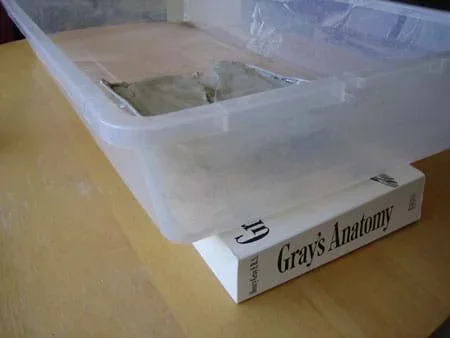 Figure 3. Prop up the plastic tub with a thick book.Copyright 2006 Tim Nicklas, ITL Program, College of Engineering, University of Colorado at Boulder
With the Students: Model Setup
- Divide the class into three groups (~ 8-10 students per team).
- Give each group a different template shape from the Riverbed Templates (PDF) attachment. The three shapes are: narrow section river, large curve river and typical river.
- Have each group create a riverbed in the clay, matching their template shape. Check the shape of the riverbed to make sure that it will create the desired effect as described in the trials below. Remind students that engineers create similar models to explore the possible effects of flooding on people and property. They use this information to develop designs and solutions.
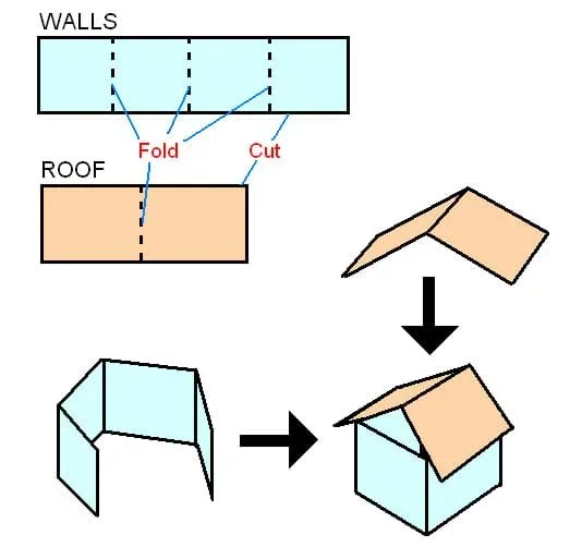 Figure 4. How to construct the model houses.Copyright 2005 Geoffrey Hill, ITL Program, College of Engineering, University of Colorado at Boulder
- Make model houses to represent human-made structures in the floodplain that might be damaged by flooding. Have each group make at least six houses using the Model House Template (PDF) and cardstock (or paper) (see Figure 4). (This is a great time to point out to the students that they are working with geometric shapes.) For each of three trials, they will use two or three new houses and assess flood damage by how much water each house absorbs.
- Have students decide the spots in the floodplain where their model houses will stand for each trial by making marks in the clay.
With the Students: Testing
 Figure 5. Activity set-up, ready for testing.Copyright 2006 Tim Nicklas, ITL Program, College of Engineering, University of Colorado at Boulder
- One at a time, have each group bring their riverbed (clay-covered baking pan) to the front of the classroom (or a central area) and place it in the tilted plastic tub. Have the rest of the class gather around to watch the water flow through the river shapes and discuss what happens during each scenario.
- When it is their turn, direct students to place two (or three) of their model houses on their floodplain on the spots they marked earlier (see Figure 5).
- Have the groups each perform three trials on their floodplains, as described in more detail below.
Group 1: Narrow Section River
Trial 1: Pour a half cup of water slowly through the narrow section riverbed model (see Figure 6). Have students record their observations and the number of damaged houses as their data for the trial. Have them remove any damaged houses. This trial shows that with a modest amount of water, it flows through the narrow river section without overflowing the riverbed.
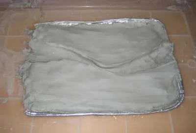 Figure 6. Model of a narrow section riverbed.Copyright 2006 Tim Nicklas, ITL Program, College of Engineering, University of Colorado at Boulder
Trial 2: Clean up any excess water in the tub. Replace any damaged houses with new ones placed on the same position, as marked on the clay floodplain. Have students pour one cup of water through the rivers bed quickly. Have students record their observations and the number of damaged houses as their data for the trial. Have them remove any damaged houses. This trial demonstrates water overflowing at the narrow point of the river when there is an increase in water flow.
Trial 3: Clean up any excess water in the tub. Replace any damaged houses with new ones placed in the same position, as marked on the clay. Have the students on the team build clay levees (piece of raised clay or small clay walls) around the narrow portion of their river. Again, pour one cup of water quickly through the river, as in Trial 2. Have students record their observations of what happened this time and the number of houses damaged. This trial shows that the river overflows on the downstream side of the levees.
Group 2: Large Curve River
Trial 1: Pour a half cup of water slowly through the large curve riverbed model (see Figure 7). Have students record their observations and the number of damaged houses as their data for the trial. Have them remove any damaged houses. This trial shows that water can flow through and around the large curve without overflowing the riverbed.
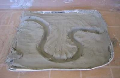 Figure 7. Model of a riverbed with a large curve.Copyright 2006 Tim Nicklas, ITL Program, College of Engineering, University of Colorado at Boulder
Trial 2: Clean up any excess water in the tub. Replace any damaged houses with new ones placed on the same position, as marked on the clay. Have students pour one cup of water through the riverbed quickly. Have students record their observations and the number of damaged houses as their data for the trial. Have them remove any damaged houses. By increasing the amount of water, this trial demonstrates water overflowing at the first large curve, flooding the peninsula within (ideally).
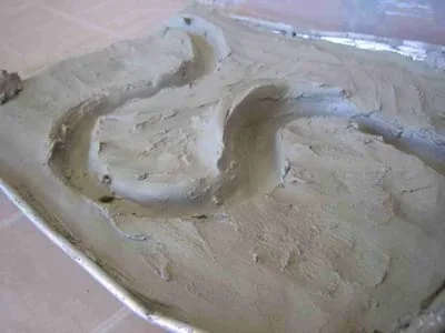 Figure 8. Model of a riverbed with a large curve and levee.Copyright 2006 Tim Nicklas, ITL Program, College of Engineering, University of Colorado at Boulder
Trial 3: Clean up any excess water in the tub. Replace any damaged houses with new ones placed in the same position, as marked on the clay. Have the students on the team build a clay levee (piece of raised clay or small clay wall) at the first curve (see Figure 8). Again, pour one cup of water quickly through the river again, as in Trial 2. Have students record their observations of what happened this time and the number of houses damaged. This trial shows that the river overflows on the downstream side of the levee.
Group 3: Typical River
Trial 1: Pour a half cup of water slowly through the riverbed model (see Figure 9). Have students record their observations and the number of damaged houses as their data for the trial. Have them remove any damaged houses. This trial shows that water can flow normally through the riverbed, without overflowing the riverbed.
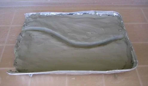 Figure 9. Model of a typical riverbed.Copyright 2006 Tim Nicklas, ITL Program, College of Engineering, University of Colorado at Boulder
Trial 2: Clean up any excess water in the tub. Replace any damaged houses with new ones placed in the same position, as marked on the clay. Have students on the team create a small blockage in the curve of their river (see Figure 10). Have students pour the same amount of water through the riverbed as they did in Trial 1. Have students record their observations and the number of damaged houses as their data for the trial. Have them remove any damaged houses. This trial demonstrates what happens when a river is blocked completely and suddenly, such as what happens during a large landslide.
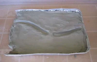 Figure 10. A typical riverbed with blockage.Copyright 2006 Tim Nicklas, ITL Program, College of Engineering, University of Colorado at Boulder
Trial 3: Clean up any excess water in the tub. Replace any damaged houses with new ones placed on the same position, as marked on the clay. Have the students on the team remove the blockage from their river. Next, have students pour one cup of water through the riverbed quickly. Have students record their observations of what happened this time and the number of houses damaged. This trial shows that even a cleared riverbed cannot withstand a flash flood.
- dam
- Large structure that retains flowing water into a reservoir to control flow.
- dike
- Another term for levee.
- flood
- Too much water in a given place at a given time. For example, river flood, coastal flood and flash flood.
- floodplain
- Normally dry land surrounding a waterway, into which flood waters spill.
- hydrological cycle
- Also called water cycle. Cycle of fresh water evaporating from bodies of water, falling as precipitation, being absorbed into the ground or flowing down into streams, rivers, etc. back into large bodies of water.
- levee
- Barrier constructed to contain the flow of water or to keep out the sea.
- model
- A small object that represents another, often larger object. Often used in testing or perfecting a final product.
- riverbed
- The earth structure that holds river water.
Pre-Activity Assessment
Brainstorming: Have the students engage in open discussion. Remind them that no idea or suggestion is "silly." All ideas should be respectfully heard. Ask the students:
- What might be dangerous about flooding?
Activity Embedded Assessment
Prediction: Have students predict the outcome for each trial and record predictions on the board. Will the river flood or not? Will the houses be affected?
Recording Observations: Have students record their observations and data about which flooding scenario caused more damage to the model houses and the floodplain, and compare these to their peers. Have students share their observations and data with the class.
Activity Discussion: As each trial is performed, discuss the activity with the entire class. Ask the students what happened to the water during each trial. Which houses (if any) were affected? In each case, how could an engineer help protect the houses during a flood? What sort of design would help solve this problem? What are the disadvantages of using human-built structures levees or dams? Use the answers to gauge students' mastery of the subject.
Post-Activity Assessment
Engineering Sketch: Have students sketch their floodplain, positioning the river in the center of their drawing. Have them color or draw arrows to indicate where the water will go if a flood occurs. Next, have them indicate where the houses were positioned for their three trials. Have them use another color or symbol to recommend safer locations where they would place the houses if they did the activity again. Direct students to create color/symbol keys in the lower right hand corner of their papers. Evaluate students' model riverbed sketches using the attached Sketch Assessment Rubric (PDF). Point out to students that engineers make sketches like these to describe the details of a riverbed and floodplain when they research and make recommendations for future development.Have students develop a design solution to help protect the houses from their flooding scenario. Have students sketch and label their proposed design. Also have the students discuss what they learned from their model floodplain that helped them develop their design.
- Using water and clay has the potential for quite a mess. Take precautions to protect surfaces and take into consideration that students' hands will be covered in wet clay. Consider conducting the activity outside.
Keep everything as dry as possible. Tilt and drain the plastic tub and clay riverbed thoroughly between each trial.
Since a small amount of water is used for each trial, a towel placed at the bottom of the riverbed, at the bottom or the tub works well to absorb the water. This is recommended, as excessive water causes a mess.
When pouring the water, make sure not to flood the riverbed at the pouring spot. Pour the water at the maximum rate that the riverbed allows at this point.
After the activity, use plaster of Paris mixed with sand to add model landforms to the river models, such as a plateau, several hills, a canyon, an open flat field and a lake. Then place houses all over the model and flood it to see which houses survive. Observe how during the flood, erosion causes several more landforms to develop and washes away some houses when the river edges fall away.
Have students design and test their own original riverbed models.
Have students look up a map for a floodplain in their area. Can they make recommendations for development (or building houses) on the floodplain, based on the riverbeds modeled in this activity?
Have students investigate how other natural disasters can cause flooding and the failure of engineering structures such as levees.
- For lower grades, any component of this activity can be performed as a demonstration. Or, spread the activity over two days to involve students in longer discussions about what is going on.
- For upper grades, have students write down their observations in a journal or chart for each trial and riverbed configuration. Or, conduct multiple setups of the three riverbed configurations by having more groups (with fewer students in each group).
- For high school students, use a large stream table instead of the small disposable baking pans. A stream table is an educational tool used to illustrate the erosion and deposition that occurs when water flows through landforms. The benefit of using a stream table is that students can observe how the water itself carves the stream bed based on the land surface and subsoil properties, which is much more realistic and provides more learning opportunities for advanced audiences. Stream tables can be purchased or built. See if your school has one; some FOSS kits have small ones. See a photo of a stream table at: http://www.sas.upenn.edu/earth/teachingdemos/c_demos_streamtable.html.
Kick-off the activity by showing students video clips of actual river floods washing away houses. For example, search YouTube for "Wisconsin flood video" to find videos of flooding near the Wisconsin Dells in 2008, such as a two-minute video called Flooding in Wisconsin at: https://www.youtube.com/watch?v=JME8XU8rZNI.
Dictionary.com. Lexico Publishing Group, LLC. Accessed March 24, 2006. (Source of some vocabulary definitions, with some adaptation) http://www.dictionary.com
- Raging Rivers
- Floodplain Modeling
- Permeable Pavement
- Watershed Balance
- Flood Analysis
- Floodplain Modeling
- Protecting Our City with Levees
- Natural Disasters: Earthquakes, Volcanoes, Tornadoes & More
Contributors
Tim Nicklas; Malinda Schaefer Zarske; Kristi Ekern; Denise W. Carlson
Supporting Program
Integrated Teaching and Learning Program, College of Engineering, University of Colorado Boulder
Acknowledgements
The contents of this digital library curriculum were developed under grants from the Fund for the Improvement of Postsecondary Education (FIPSE), U.S. Department of Education and National Science Foundation (GK-12 grant no. 0338326). However, these contents do not necessarily represent the policies of the Department of Education or National Science Foundation, and you should not assume endorsement by the federal government.
Copyright
2006 by Regents of the University of Colorado.