
Landscape Models & Roadways: Carve that Mountain
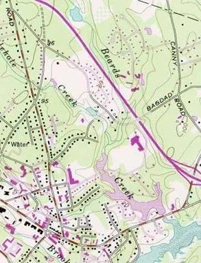 Figure 1. Engineers use topographic maps to help them decide where to build roads and other modern amenities.Copyright Natural Resource Conservation Service, U.S. Department of Agriculture http://www.nh.nrcs.usda.gov/technical/Ecosystem_Restoration/Salt_marsh_projects.html
Students consider the Earth's major types of landforms such as mountains, rivers, plains, hills, canyons, oceans and plateaus. Student teams build three-dimensional models of landscapes, depicting several of these landforms. Once the models are built, they act as civil and transportation engineers to design and build roads through the landscapes they have created. The worksheet is provided in English and Spanish.
To build infrastructure for transportation, engineers must understand the landforms and the geology of the Earth. Engineers are responsible for deciding where to put roads, highways, train tracks, tunnels and bridges. Engineers are also involved in city planning and determining the locations of water and power resources for cities and communities along the way. This can sometimes be very challenging in areas with mountains, hills, waterways and dense forests.
After this activity, students should be able to:
- Identify the major features of the Earth's surface such as mountains, rivers, plains, canyons and plateaus.
- Describe how engineers need a good understanding of local landforms in order to design transportation systems.
- Explain why engineers build models before final projects.
- Students will develop an understanding of the attributes of design.
Grades K-12
Do you agree with this alignment? - Models are used to communicate and test design ideas and processes.
Grades 3-5
Do you agree with this alignment?
- 3-5-ETS1-1 Define a simple design problem reflecting a need or a want that includes specified criteria for success and constraints on materials, time, or cost.
Grades 3-5
This resource focuses on the following Three Dimensional Learning aspects of NGSS:
Science & Engineering Practices- Define a simple design problem that can be solved through the development of an object, tool, process, or system and includes several criteria for success and constraints on materials, time, or cost.Do you agree with this alignment?
Disciplinary Core Ideas- Possible solutions to a problem are limited by available materials and resources (constraints). The success of a designed solution is determined by considering the desired features of a solution (criteria). Different proposals for solutions can be compared on the basis of how well each one meets the specified criteria for success or how well each takes the constraints into account.Do you agree with this alignment?
Crosscutting Concepts- People's needs and wants change over time, as do their demands for new and improved technologies.Do you agree with this alignment?
Do you agree with this alignment? - Define a simple design problem that can be solved through the development of an object, tool, process, or system and includes several criteria for success and constraints on materials, time, or cost.
Each group needs:
- cardboard, 2 ft x 2 ft square piece
- Winding Road Worksheet (PDF), one per person
To share with the entire class:
- construction paper, black plus various other colors
- colored markers and/or paint
- cotton balls, for the tops of mountains
- craft sticks, for making bridges
- paper-mâché or clay, for creating landforms
- scissors
- glue
- tape
Who has driven on a road before? Do you know of any roads near our school? Who creates these roads? Who decides where they go? Did you know that engineers usually make the plans for the roads that connect our communities? Have you ever driven through a tunnel? Do you know how that tunnel was built? Who decided where to dig that tunnel and how to make it safe for us? Again, engineers! How do engineers know where to put tunnels and bridges? How do engineers determine where to build the roads? We are going to learn more about that today.
The landscape of the Earth is very different from place to place. Have you been somewhere that looks very different from here—maybe to the top of a mountain, near the ocean or an area with a wide river, or a place where the land is very flat or has rolling hills? What different kinds of landscapes do you know about? (List on the classroom board the landforms students mention.) Tell me about the landscape around our school.
Many different types of landforms make up the landscape around us. Can you picture what each of these looks like? (During this explanation, point to the ones on the classroom board list and add any new landforms to the list as you go through them. To help with the explanations, show students any available pictures of the landform types.) Well, hills are a raised mound of land that can be small or large. Mountains are very tall places on Earth, much higher than hills. Plateaus are like mountains except they have large, flat tops. Plains are flat lands with only small changes in elevation—almost no hills there! An ocean is a large body of salt water that surrounds a continent, and a river is a long and more narrow moving body of water that eventually empties into an ocean. What else? Well, a valley is a low point in the Earth's surface, usually between ranges of hills or mountains, and a canyon is a deep narrow valley with steep sides that usually has a stream flowing through it. All these various types of landforms shape the surface of the Earth!
How do engineers know where to build roads, tunnels and bridges across and through these landforms? They know because for many years geologists have studied the landscape and its composition. Geotechnical engineers study the different rocks and soils of the Earth and work with civil and transportation engineers to design and build roads, highways and train tracks to provide safe places for travel. What would happen if a tunnel collapsed or if a road fell off the edge of a mountainside? This rarely happens because engineers have studied and understand the landforms that they are building on to make sure the roads and tunnels are safe. They choose locations where it is safe to build roads, bridges and tunnels, and then create designs and decide on strong materials to build them.
Often, engineers build smaller-sized models of transportation systems before they build the real thing. This helps them experiment with different ideas, create safe designs and explain to other people, like citizens and city planners, their reasons for placing roads or tunnels in certain places. In this activity, you will act like engineers and build landscape models and then decide the best places to put roads across your models. Are you ready?
Before the Activity
Gather supplies and make copies of the Winding Road Worksheet (PDF).
With the Students
Day 1
- Organize the class into groups of two to four student each.
- Explain to students that each team will create a small-scale landscape model of its choosing using a variety of materials. Explain the model requirements: Each model must include at least one body of water and one mountain. The body of water must take up about one-quarter of the cardboard area (~6 x 6 inches) and the mountain must occupy at least 4 inches in diameter. Beyond these requirements, groups may add any other landforms that they like, such as hills, rivers, canyons, plateaus and plains, in any arrangement.
- On the classroom board, make a list or T-chart of the landforms. Next to each listed item, have the class brainstorm materials to use for creating each landform from the available supplies.
- Have groups design plans for their landscape models. Direct them to list on their worksheets the landforms they will create and indicate what materials they will use to make them.
- Have teams build their landscape models and leave them to dry overnight.
Day 2
- Once the landscape models are built, have students sketch on their worksheets detailed drawings of them, accurately indicating all landform locations as well as elevations, water, forests and open areas. Refer to the Figure 1 map example.
- Next, tell students that they are going to act as if they are civil engineers who are given the job to design a road through the landscape for a new community that is moving in. The new road must go from one corner of the model to the other. Have student teams each draw on their worksheet landform pictures a plan for exactly where they are going to place their roads. Expect that in laying out a road from one corner of the cardboard to the other, the student engineers will run into landforms that require them to adjust the route around the terrain and possibly design some bridge and tunnel structures to enable the road to get to the other corner. What creative ideas do they have to create safe routes?
- Have students add their roads to their models using black construction paper and any bridges using craft sticks.
- When all groups are finished, have teams show their models to the class and explain why they put their roads where they did.
Pre-Activity Assessment
Question/Answer: Ask students questions and have them raise their hands to respond. Write their answers on the classroom board. Students' answers reveal their depth of understanding about landforms.
- Where do we find water?
- Where do we find land?
- What are some types of landforms on our planet?
Activity Embedded Assessment
Worksheet: Have students individually complete the Winding Roads Worksheet (PDF) as they work in their engineering teams during the course of the activity. Review their answers to gauge their mastery of the subject.
Group Questions: During the activity, ask the groups:
- How is a plateau different from a mountain? (Answer: Plateaus are elevated flat surfaces, while the tops of mountains typically come to points, peaks and jagged ridges.)
- How is ocean water different from river water? (Answer: Ocean water is very salty; river water is usually fresh or not as salty as the ocean. Rivers are usually long and winding through canyons, hills or plains, while oceans and lakes are broader and wider bodies of water.)
Post-Activity Assessment
Class Discussion: Ask students questions and have them raise their hands to respond. Students' answers reveal their engagement and depth of understanding.
- What kinds of landforms did you put in your model?
- What other landforms could you add to your model?
- Why do you think is it important for engineers to build models?
Class Presentations: Working in groups of two to four students each, have teams give class presentations in which they dynamically present the concepts they learned in the unit. Encourage role-playing and creativity by having teams act out the scenario of a civil engineering company that has just been hired to put a road through its model landscape. Other students in the audience can role play people who want the road for travel, people who want to turn that landscape into a park, other engineers, etc. Have teams explain the model landscape and where they would put the road. Also have them talk about any challenges they might face when trying to put a road around or through the various landforms.
Map It! Have students make to-scale maps of their landscape models and the roads they designed and built through them.
Sometimes it helps to have a landscape model built in advance to show students. If you do this, do not put a road running through it, so they cannot entirely copy the example model.
If students have trouble building tunnels through the mountains in their landscapes, simplify the process by having them indicate a mountain tunnel by having the road lead up to the mountain, color black marks for the tunnel entrance and exit, and then continue the road on the other side of the mountain.
If using paper-mâché, it may be difficult to build tunnels through mountains, but the instructor can use a utility knife to make the cuts as long as the paper-mâché is not too thick.
Challenge students to create landscape models that fit and connect next to one or more other teams' models, maybe even the entire class. How might two or more engineering teams work together to design the roads and communities that cover their landscapes?
Have students think about the challenge of designing transportation that does not use a lot of fuel or energy around existing landforms and create a design for an entirely new futuristic city. Or have them describe an alternative idea for energy-saving transportation around their own city. Ideas for innovative energy-saving transportation might include roller coasters everywhere, cities shaped like a bowl with tiny cars rolling down the sides of the bowl to the next destination, or a way to have citizens hang glide to their next locations.
- For lower grades, give students explicit directions on landform locations and sizes. Also, make an example model for them to examine before they begin the activity.
- For upper grades, encourage more creativity in student landscape designs. When building their models, have them practice measuring by requiring them to measure the length of their roads and the sizes of the different landforms, including these measurements on their worksheets.
- Have advanced students design topographic maps of their landscape models that include elevations from the bottom of the cardboard base.
USGS topographical map. New Hampshire Cooperative Salt Marsh Projects, Beard's Creek, Durham, NH. Natural Resource Conservation Service, U.S. Department of Agriculture. Accessed August 15, 2006. Originally found at http://www.nh.nrcs.usda.gov/technical/Ecosystem_Restoration/Salt_marsh_projects.html
- Earth's Changing Surface
- The Earth is a Changin'
- Geology and Major Landforms: Sea to Sky
- Landscape Models & Roadways: Carve that Mountain
- Earth Rocks!
Contributors
Sara Born; Malinda Schaefer Zarske; Janet Yowell
Supporting Program
Integrated Teaching and Learning Program, College of Engineering, University of Colorado Boulder
Acknowledgements
The contents of this digital library curriculum were developed under grants from the Fund for the Improvement of Postsecondary Education (FIPSE), U.S. Department of Education and National Science Foundation (GK-12 grant no. 0338326). However, these contents do not necessarily represent the policies of the DOE or NSF, and you should not assume endorsement by the federal government.
Copyright
2006 by Regents of the University of Colorado