
Geology and Major Landforms: Sea to Sky
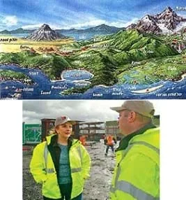 Figure 1. The many different landforms on planet Earth. Engineers must know about the earth before they begin a construction project.Copyright National Aeronautics and Space Administration, Dr. Nicholas Short's Remote Sensing Tutorial http://www.nasa.gov/ and U.S. Department of Transportation, Federal Highway Administration http://www.fhwa.dot.gov/publications/publicroads/10mar/02.cfm
Students learn about major landforms (such as mountains, rivers, plains, valleys, canyons and plateaus) and how they occur on the Earth's surface. They learn about the civil and geotechnical engineering applications of geology and landforms, including the design of transportation systems, mining, mapping and measuring natural hazards.
Engineers must understand the landforms and the geology of the Earth if they are to build transportation infrastructure. Engineers are responsible for deciding where to put roads, highways, train tracks and bridges. They must also locate telephone cables, electricity towers, and wind and solar farms, which is often challenging in remote areas with large mountains, hills or dense forests. Geotechnical engineers study landforms and their implications in mining, infrastructure development, natural-hazard mitigation and environmental remediation. Engineers are involved in designing digital maps, based on aerial photography and satellite imagery, to help solve engineering challenges for the benefit of humanity and our world.
After this lesson, students should be able to:
- Identify the major features of the Earth's surface such as mountains, rivers, plains, canyons and plateaus.
- Describe how engineers use knowledge of landforms for transportation, mining, mapping and measuring natural hazards.
- Analyze and interpret data identifying ways Earth's surface is constantly changing through a variety of processes and forces such as plate tectonics, erosion, deposition, solar influences, climate, and human activity
Grade 5
Do you agree with this alignment?
- Modern communities are usually planned according to guidelines.
Grades 3-5
Do you agree with this alignment?
- 4-ESS1-1 Identify evidence from patterns in rock formations and fossils in rock layers to support an explanation for changes in a landscape over time.
Grade 4
This resource focuses on the following Three Dimensional Learning aspects of NGSS:
Science & Engineering Practices- Identify the evidence that supports particular points in an explanation.Do you agree with this alignment?
Disciplinary Core Ideas- Local, regional, and global patterns of rock formations reveal changes over time due to earth forces, such as earthquakes. The presence and location of certain fossil types indicate the order in which rock layers were formed.Do you agree with this alignment?
Crosscutting Concepts- Science assumes consistent patterns in natural systems.Do you agree with this alignment?
Do you agree with this alignment? - Identify the evidence that supports particular points in an explanation.
- DCI.ESS2.B.3-5.2 The locations of mountain ranges, deep ocean trenches, ocean floor structures, earthquakes, and volcanoes occur in patterns. Most earthquakes and volcanoes occur in bands that are often along the boundaries between continents and oceans. Major mountain chains form inside continents or near their edges. Maps can help locate the different land and water features areas of Earth.
Grade 4
Do you agree with this alignment?
The landforms of this Earth are vast and diverse. For purposes of this lesson, the following landforms will be explained: mountains, rivers, plateaus, canyons, oceans and hills.
Landform Formation and Plate Tectonics
To study landforms, one must first understand how landforms are formed. The core to understanding landforms is the composition of the Earth and plate tectonics.
The Earth is composed of four layers: crust, mantle, outer core and inner core. The outer crust is made of less dense material while the mantle is much denser. The crust and the rigid, outer zone of the mantle make up a layer called the lithosphere. The lithosphere is broken into 12 large pieces called plates. The zone below the lithosphere is the asthenosphere. The asthenosphere is a freely flowing layer. Convection currents in the asthenosphere cause the plates in the lithosphere to constantly move.
It has long been suspected that the Earth is a dynamic changing place. During humans' travels around Earth, seashells have been discovered on mountain tops. And, even more surprising, rock bands in South America and Africa had the same mineral content. How can this be? It was not until the 1960s that geologists gained the technology to understand the processes that move the Earth's plates, and identified 12 major pieces of crust that float across the surface of the Earth, similar to how icebergs float on the ocean. Currents move these plates 1-4 inches per year.
Landforms are comprised of mountains, plateaus, plains, rivers, valleys and canyon, discussed in the following sections.
Mountains
Mountains are created when the plates of the Earth collide into each other. The crust folds upward and forces the plates to form a mountain range. The rocks of the world's mountain ranges are up to 3.5 billion years old. The rocks that form these mountain ranges were once buried deep beneath the Earth. When the Indian subcontinent and the Eurasian plates collided 24 billion years ago, the highest mountain range in the world was created, the Himalayas.
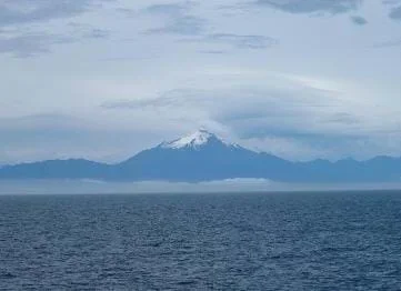 Figure 2. Corcovado, a volcanic mountain.Copyright U.S. Department of Commerce, National Oceanic and Atmospheric Administration http://www.noaa.gov/
We identify five types of mountains, each named by its method of formation:
- Fold Mountain: A mountain that forms when two of the Earth's plates collide, and the crust where they meet is bent and buckled into folds. The folding results from extreme pressure causing the rock layers to fold rather than break.
- Fault-Block Mountain: A mountain that forms when cracks in the Earth's crust shift, causing the plates to shift or sink. This causes the adjoining plates to rise and form a block mountain
- Dome Mountain: These mountains form when magma causes pressure on the crust, but is unable to work its way to the surface of the Earth. The pressure of the magma pushes the layers of rock above it into a round- or dome-shaped bulge, and eventually hardens into rock.
- Volcanic Mountain: These mountains form when magma is forced out through weak spots in the Earth's crust, then piles up around the vent, and hardens into a mountain shape. Figure 2 illustrates a volcanic mountain.
- Erosion Mountain: These mountains form when water, wind, storms or ice from moving glaciers carve the landscape, leaving behind mountain or hill formations.
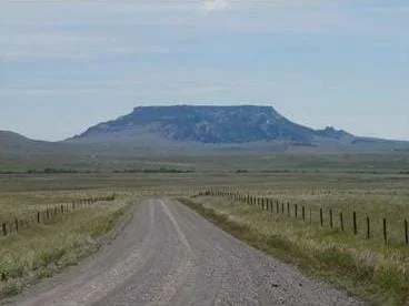 Figure 3. Square Butte, a national landmark in Montana. It is an excellent example of a natural butte, formed from magmatic rock.Copyright U.S. Department of the Interior, National Park Service http://www.nature.nps.gov/
Plateaus
Plateaus are broad, flat-topped mountains with steep sides that are the result of various tectonic forces. A plateau can form from an upwelling of magma pushing its way toward the surface but not breaking through, causing a large flat area of land to be pushed up. Colliding plates also form plateaus. Mountains form near the collision of colliding plates, while plateaus form farther from the source. Another method of plateau formation is erosion or glacier deterioration. The Earth's crust may rise up as a result of the surface of the Earth becoming lighter due to diminishing glaciers in a particular area. Smaller plateaus are called mesas or buttes, as shown in Figure 3.
Rivers and Other Water Bodies
Water covers two-thirds of the Earth's surface in both liquid and solid forms. Much of this water is salt water. It is estimated that around 70% of the Earth's surface is covered with oceans. Salt water accounts for 97.24% of the water resource on planet Earth, but this water is unfit for human consumption because of its high salt content. Methods for desalination are expensive and not widely used. Another 2.14% of the Earth's water is tied up in icecaps and glaciers. Of the amount left, 0.61% is groundwater. Only 0.0091% of the water on planet Earth resides in rivers and lakes. Of the ground and surface water that is supposedly available for drinking, only 0.3% of this is suitable for human consumption.
Rivers are a key player in shaping the landscape. They carve canyons over thousands of years and transport massive amounts of sediment to create other landforms. For example, it is estimated that the Colorado River used to carry 500,000 tons of silt through the 277 mile stretch of the Grand Canyon per day. Rivers often originate in the mountains either as glacial streams or as a result of snowmelt. These water bodies often start as a trickles and quickly move to become a steep fast-flowing narrow rivers. As a river makes its way down and across the Earth on its way to the sea or ocean, it often slows down, widening the path it carves. The massive Colorado River drains 242,000 square miles of land, and travels 1,450 miles across the states of Wyoming, Colorado, Utah, New Mexico, Arizona, Nevada and California. The river starts on the west side of the Rocky Mountains in Colorado and flows into the Gulf of California (see Figure 4). Heavy use has ceased its union with the sea.
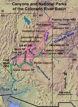 Figure 4. The path of the Colorado River.Copyright U.S. Department of the Interior, U.S. Geological Survey http://3dparks.wr.usgs.gov/3Dcanyons/images/colorado_river.jpg
Canyons and Valleys
Wind and water erosion (such as as in the form of rivers) is a key component to canyon formation. Water — and in this case, rivers specifically — follows the path of least resistance. Often, a river cuts through broken rock along a fault, and over time, erosion increases the width of the canyon. Eventually, that crack widens tremendously, and a river valley and/or canyon forms, as depicted in Figure 5.
While the valleys and canyons formed by years of water and wind erosion lend to some of our nation's most beautiful vistas, these same landmarks and natural treasures can be very dangerous due to their sheer height. Thrill-seeking rock climbers and hang gliders attempt to climb or fly off of these tall canyons each year, leading to many joyous personal triumphs, as well as some unfortunate deaths due to falls. And, kayakers and rafters enjoy the rapid water as it flows through these narrow canyons, creating a challenging and, sometimes devastating, course of recreation.
Landforms — mountains, plateaus, plains, rivers, valleys and canyons —offer great challenges for engineers when designing infrastructure that either go through or around them. Engineers must be knowledgeable of the natural surroundings in order to protect the integrity (strength) and retain the beauty of these natural wonders when designing bridges, tunnels, train tracks and roads. Even when burying telephone or electrical cables, engineers must be knowledgeable in order to locate the cable in safe, reliable places. Geological and civil engineers must know about landforms in order to help inform and protect us from volcanoes and earthquakes, know where to locate renewable energy sources, and where to drill for natural resources (such as petroleum and minerals) that enable us to survive day to day.
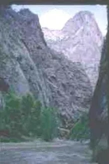 Figure 5.The Narrows at Zion National Park in Utah. The Virgin River flows through the Narrows, widening and deepening the canyon.Copyright U.S. Department of Commerce, National Oceanic and Atmospheric Administration, National Geophysical Data Center http://www.noaa.gov/
When you walk outside, how does the land around you change shape and look different? What are some things that change the shape of the Earth's surface? For example, have you ever been to the mountains? Have you ever been to the ocean? How are they different? Do you have a river near your school? How does a river change the land when it runs through it? Do you think that land in Africa or South America looks the same as it does in America? Were these landscapes always here or did they happen over time?
Well, humans have long suspected that the Earth's landscape or surface is a changing place. People have traveled the Earth and found seashells on mountain tops! Some scientists noticed that rock bands in South America and Africa contained the same minerals. So, how did this happen when these areas are so far apart? The planet Earth is composed of four layers: crust, mantle, outer core and inner core. Currents in the liquid-like upper mantle cause pieces of the crust to constantly be on the move. Scientists — called geologists — have discovered that 12 large pieces of crust float across the surface of the Earth, similar to how icebergs float on the ocean. We call these pieces of crust plates. The currents move the plates 1-4 inches per year.
Mountains, plateaus, plains, rivers, valleys and canyons are all examples of landforms. Plateaus are special types of mountains. They are flat-topped and wide mountains with steep sides. Plains are large flat pieces of landscape or crust. Rivers are important in shaping the landscape, especially since water covers two-thirds of the Earth's surface. Rivers can carve deep canyons in the Earth's surface over thousands of years. They often start as trickles in the mountains, as glacial streams or as a result of snowmelt, and quickly move to steep, fast-flowing narrow rivers. As a river makes its way down and across the Earth on its way to the sea or ocean, it often slows down and widens. Rivers follow the path of least resistance, meaning that a river flows through the path that is easiest for it to follow. Often, a river cuts into broken rock and over time (via the process of erosion) makes a valley or canyon.
Have you ever thought about how the roads you drive on were built or constructed? Have you ever been on a narrow road across a river or in a tunnel that goes right through a mountain? Who do you think created them? Engineers did! Understanding the landforms and the geology of the Earth are important to many types of engineering. First of all, civil engineers design all the roads, bridges and tunnels that we use every day for transportation. These engineers are responsible for deciding where to put any highways, train tracks and bridges. They must also figure out where to put telephone cables, utility lines and electrical towers. This can sometimes be a challenge when large mountains, rivers or canyons are in the way. Environmental engineers who work with renewable energy resources, such as wind power, must find flat open places to place their generators where that the wind constantly turns the windmills. Some geotechnical engineers study landforms and how we can use them in mining for minerals and oil. Geotechnical and civil engineers develop ways to measure and protect us from natural hazards, such as earthquakes and volcanoes. Some engineers are involved in designing digital maps, based on aerial (up in the sky) or space photography (also called satellite imagery), to help solve engineering challenges. Refer to the Landscape Models & Roadways: Carve that Mountain activity where students can act as civil engineers to design their own three-dimensional model of a landscape to show major landforms.
Who remembers what the Earth's crust is? Well, it's the top layer of land on the surface of the Earth. Did you know that your school is sitting on a piece of Earth's crust right now? Even as we sit here, there are large pieces of crust that actually float across the surface of the Earth, just like an iceberg that floats on the ocean.
Who can name an example of a landform? (Answers: Mountains, plateaus, plains, rivers, ocean, valleys and canyons.) Can you see these landforms changing? It certainly does not seem like you can see a mountain change, does it? Well, the landforms we see today are the result of thousands of years of very slow change. What we see today sure seems to be permanent; yet the Himalayan mountains are currently still growing. Wow!
Why do engineers care about landforms? Well, engineers design and build all sorts of technologies that interact with the landforms all around us. Engineers design all the roads, bridges, and tunnels that we use to travel from one part of the Earth's crust to the next, over rivers and through mountains. Some engineers work with renewable energy resources and must find flat open places to place the wind farms or solar farms. Other engineers need to know about landforms for mining, map making, and developing ways to measure and protect us from natural hazards, such as mudslides, earthquakes and volcanoes. Engineers really need to know a lot about the Earth's crust and landforms to help made our planet safer and healthier for us!
- canyon
- A deep narrow valley with steep sides; often has a stream flowing through it.
- hill
- A raised mound of land.
- mountain
- A very tall natural place on Earth, higher than a hill.
- ocean
- A large body of salt water that surrounds a continent. Oceans cover more than two-thirds of the Earth's surface.
- plain
- Flat land that has only small changes in elevation.
- plateau
- A large, flat area of land that is higher than the surrounding land.
- river
- A flowing body of water that usually empties into a sea or ocean.
- valley
- A low point in the Earth's surface, usually between ranges of hills or mountains.
Pre-Lesson Assessment
Discussion Questions: Solicit, integrate and summarize student responses.
- How would you describe the Earth's surface?
- What different types of environments exist on our planet? (Examples: rainforests, mountains, oceans, etc.)
Post-Introduction Assessment
Matching: Create a list of the following landforms. Randomly write the names of the landforms on the left side of the board and definitions or sketches of the landforms on the right side of the board. As a class, have students draw arrows to match the correct sides together. See Figure 6 as an example.
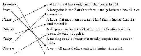 Figure 6. Post-Introduction Landform Matching Assessment example.Copyright 2006 Sara Born and Janet Yowell, University of Colorado Boulder
Engineering Discussion: Solicit, integrate and summarize student responses.
- What types of landforms might be more difficult for engineers to work with when building roads, highways, bridges, and train tracks? Why?
Have students investigate the Colorado River and how it has helped to shape the landscape across the western U.S.
Have students determine what types of landforms are in the area of their school. Can they see mountains, hills, a river or plains? Ask them to identify examples of engineering around the community or state that demonstrate an engineer's knowledge of landforms (examples include, roads, bridges, wind farms, etc.).
Have students investigate more about plate tectonics. Where are earthquake zones? What types of technologies have engineers designed to help us measure and predict earthquakes?
Have students investigate the five types of mountains: fold, fault-block, dome, volcanic and erosion. Since each is named by the method of formation, have students pick one or two types of mountains to learn about and draw pictures of how they are formed.
"Erosional Landforms." May 3, 2005. Natural Hazards, National Geophysical Data Center, NOAA Satellite and Information Service. Accessed August 1, 2006. Originally found at http://www.ngdc.noaa.gov/ngdc.html.
Short, Nicholas, Sr., National Aeronautics and Space Administration, Dr. Nicholas Short's Remote Sensing Tutorial, "The Remote Sensing Tutorial," May 19, 2006, Originally found at http://www.nasa.gov/ Accessed July 24, 2006.
U.S. Department of Commerce, National Oceanic and Atmospheric Administration, NOAA STRATUS Teacher at Sea, December 17, 2004, Originally found at http://www.noaa.gov/ Accessed August 10, 2006.
U.S. Department of the Interior, National Park Service, Nature and Science, National Natural Landmarks, NNL Guide, "Montana, Square Butte," August 1980. Originally found at http://www.nature.nps.gov/. Accessed August 10, 2006. Now found at https://www.nps.gov/subjects/nnlandmarks/site.htm?Site=SQBU-MT. Accessed November 9, 2020.
U.S. Department of the Interior, U.S. Geological Survey, Geology of National Parks, "3D Photography of the Powell Survey (1870-1879) of Colorado River Canyon Country," February 14, 2004, Originally found at http://3dparks.wr.usgs.gov/3Dcanyons/images/colorado_river.jpg. Accessed August 10, 2006.
Contributors
Sara Born; Malinda Schaefer Zarske; Janet Yowell
Supporting Program
Integrated Teaching and Learning Program, College of Engineering, University of Colorado Boulder
Acknowledgements
The contents of this digital library curriculum were developed under a grant from the Fund for the Improvement of Postsecondary Education (FIPSE), U.S. Department of Education and National Science Foundation GK-12 grant no. 0338326. However, these contents do not necessarily represent the policies of the Department of Education or National Science Foundation, and you should not assume endorsement by the federal government.
Copyright
2006 by Regents of the University of Colorado.