
Acting Out Animal Tracking: Map-a-Buddy
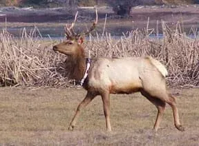 An elk with a radio tracking collar.Copyright Forest Service, U.S. Department of Agriculture http://www.fs.usda.gov/wps/portal/fsinternet/!ut/p/c5/04_SB8K8xLLM9MSSzPy8xBz9CP0os3gDfxMDT8MwRydLA1cj72BTQxNjAwgAykeaxRtBeY4WBv4eHmF-YT4GMHkidBvgAI6EdIeDXIvfdrAJuM3388jPTdUvyA2NMMgyUQQAFrridQ!!/dl3/d3/L0lDU0lKSWdra2trIS9JSFJBQUlpQ2dBek15cXhtLzRCRWo4bzBGbEdpdC1iWHV3RUEhLzdfME80MEkxVkFCOTBFMktTNTZCNjAwMDAwMDAvc2EuU1RFTFBSREI1MzEyNzk2/?pname=Forest%20Service%20-%20Tule%20bull%20with%20radio%20tracking%20collar.&recid=&counter=null.0&actid=&navtype=BROWSEBYSUBJECT&ttype=photogallery&navid=130120000000000&cid=3290&pnavid=130000000000000&ss=110508
Students are introduced to the concept of tracking and spatial movements of animals in relation to the environments in which they live. Students improve their understanding of animal tracking and how technology is used in this process.
Engineers creatively design the remote sensing tracking devices and tracking systems used to gather data, map and analyze the movement of animals in their environment for a wide range of purposes, including commercial, conservation and scientific research; fishing and ecotourism industries; ocean, gulf and bay shipping lane routing; and urban development planning.
After this activity, students should understand the purpose and reasons for performing animal tracking. In addition, they should be able to comprehend and interpret the data from this foraging activity.
- CCSS.Math.Content.5.MD.B Represent and interpret data.
Grade 5
Do you agree with this alignment?
- A wide range of specialized equipment and practices is used to improve the production of food, fiber, fuel, and other useful products and in the care of animals.
Grades 6-8
Do you agree with this alignment? - STEL-3E Analyze how different technological systems often interact with economic, environmental, and social systems.
Grades 6-8
Do you agree with this alignment? - STEL-8M Use instruments to gather data on the performance of everyday products.
Grades 6-8
Do you agree with this alignment?
- MS-LS2-5 Evaluate competing design solutions for maintaining biodiversity and ecosystem services.
Grades 6-8
This resource focuses on the following Three Dimensional Learning aspects of NGSS:
Science & Engineering Practices- Evaluate competing design solutions based on jointly developed and agreed-upon design criteria.Do you agree with this alignment?
Disciplinary Core Ideas- There are systematic processes for evaluating solutions with respect to how well they meet the criteria and constraints of a problem.Do you agree with this alignment?
- Biodiversity describes the variety of species found in Earth's terrestrial and oceanic ecosystems. The completeness or integrity of an ecosystem's biodiversity is often used as a measure of its health.Do you agree with this alignment?
- Changes in biodiversity can influence humans' resources, such as food, energy, and medicines, as well as ecosystem services that humans rely on—for example, water purification and recycling.Do you agree with this alignment?
Crosscutting Concepts- The uses of technologies and any limitations on their use are driven by individual or societal needs, desires, and values; by the findings of scientific research; and by differences in such factors as climate, natural resources, and economic conditions. Thus technology use varies from region to region and over time.Do you agree with this alignment?
- Small changes in one part of a system might cause large changes in another part.Do you agree with this alignment?
- Scientific knowledge can describe the consequences of actions but does not necessarily prescribe the decisions that society takes.Do you agree with this alignment?
Do you agree with this alignment? - Evaluate competing design solutions based on jointly developed and agreed-upon design criteria.
- CCSS.Math.Content.5.MD.B Represent and interpret data.
Grade 5
Do you agree with this alignment?
- 5.L.2.3 Infer the effects that may result from the interconnected relationship of plants and animals to their ecosystem.
Grade 5
Do you agree with this alignment?
- paper
- poster board, for the master map
- pens, markers and/or crayons of various colors
- candy, various types
- Graphing on a coordinate grid.
- Knowledge from the associated lesson Marine Animal Tracking aids students' understanding of this activity.
Why is it important to understand and perform animal tracking? (Listen to student ideas and then supplement, as necessary.) The information learned from animal tracking is used for commercial, conservation and scientific research. Economically, animal tracking data is used by fishing and ecotourism industries as means to locate marine organisms. Conservation organizations also rely on tracking data to determine animal spatial movements, thus influencing locations of urban development. Tracking data is frequently collected by researchers to gain knowledge of animal behavior such as migration between foraging, breeding and nursery grounds. For what other purposes might we apply animal tracking information? (Perhaps to determine ocean, gulf and bay shipping lanes that are less disturbing to animals, or for smarter urban planning for the same reason.)
In today's activity, you will be monitoring animal foraging behavior on a spatial scale. You will be paired up with another student to track one another over a pre-defined region. Let's get started!
Background
In this interactive activity, students track one another over a pre-defined region as an example of monitoring animal foraging behavior on a spatial scale. Various candy types serve as a food source from which foraging behavior can be monitored. Students use pre-designed trail maps (maps that include the pre-determined candy trails). The initial trail should be composed of one type of candy with external branches composed of different candy types. Once encountering a branching point, a student must choose which direction to travel without straying from the chosen path. While a student is following the path, a fellow classmate records the foraging path on the provided map. After all the data is collected, students record their final foraging maps on the instructor's master map with a unique color. The master map enables students to compare various spatial movements over the habitat.
Before the Activity
Gather materials.
Prepare a master map to determine how to lay out the candy. Place the candy according to the map design.
With the students: (Note: Answers are included in procedures)
- Divide the class into groups of two students each.
- Each group member takes a turn being the recorder or forager. While one student is following the path, the other tracks and record the other student's progress on the map. Inform students that they should NOT collect the candy while on their journeys, but wait to receive the "rewards" of their foraging efforts until the activity end.
- After each group completes the spatial mapping activity, each student records the data on the teacher's master map using different colored pens, markers or crayons.
- As a class, query students about the different types of information and patterns that arose from the data. Look at the master map. Ask for observations. Review the many applications of animal tracking information, such as in relation to commercial, conservation and scientific research decisions. See additional questions in the Assessment section.
- spatial location
- Where an object or animal is located in space.
- latitude
- The angular distance north or south of the Earth's equator, measured in degrees along a meridian, as on a map or globe.
- longitude
- Angular distance on the Earth's surface, measured east or west from the prime meridian at Greenwich, England, to the meridian passing through a position, expressed in degrees (or hours), minutes, and seconds.
- tracking
- To observe or monitor the course of (animal, for example), as by radar.
Pre-Activity Assessment
- Engage students in a discussion regarding knowledge on animal tracking.
- Encourage students to hypothesize why animal tracking is important and whether they think technologies can aid in species conservation.
Activity Embedded Assessment
- Did the students correctly follow the outlined procedure?
Post-Activity Assessment
Did the students gain an understanding on the importance of animal tracking?
- How does current tagging technology helpful in tracking animals?
- What does the candy in the activity represent?
- Give one example of a commercial use of animal tracking. (For example, fishing boats for food, fishing boats for recreation, SCUBA boats)
- Give one example of a conservation effort which could use this data. (For example, knowing which areas are sensitive and where laws may be necessary to help protect endangered species.)
Lead a concluding discussion to see if students were able to draw final conclusions regarding foraging behavior and the collection of spatial data. Ask the students:
- What factors determined the path of individual students? (candy preference) Do you think animals vary their migratory paths depending on preferences such as food availability?
- What are some of the problems and challenges associated with animal tracking technology? Why do we still not know migratory or traveling paths for many species?
- What might be some of the challenges engineers face as they design tracking devices and tracking systems to gather and map data of animal movements? What are your ideas?
Confirm that students do not have food allergies to certain candy types. As necessary, replace candy with other items or objects.
Engage students in in-depth discussions on the impacts of urban development on animal movement. Choose a site on the master map to build an urban center and query students about the impacts on animal behavior.
Assign students to research the various types of tracking tags, tracking systems and other technologies designed by engineers to gather and map data of animal movements.
- Marine Mapping
- Habitat Mapping
- Marine Animal Tracking
- Acting Out Animal Tracking: Map-a-Buddy
Contributors
Kimberly Goetz; Jonelle Stovall; Melissa Sanderson; Heather Kerkering
Supporting Program
Engineering K-PhD Program, Pratt School of Engineering, Duke University
Acknowledgements
This content was developed by the MUSIC (Math Understanding through Science Integrated with Curriculum) Program in the Pratt School of Engineering at Duke University under National Science Foundation GK-12 grant no. DGE 0338262. However, these contents do not necessarily represent the policies of the NSF, and you should not assume endorsement by the federal government.
Copyright
2013 by Regents of the University of Colorado; original © 2004 Duke University