
Habitat Mapping
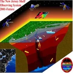 An example of marine habitat mapping.Copyright http://marine.rutgers.edu/cool/
How do we study what we cannot see or touch? Students learn about technologies used for underwater mapping, such as benthic habitat images produced by GIS. They participate in a class discussion on why habitat mapping is useful and how current technology works to make bathymetry mapping possible. Through inquiry-based questions, students brainstorm about the importance of bathymetry mapping to help us explore and map the seafloor, marine habitats and the water column. They examine collected data and draw conclusions. Students learn how remote sensing and underwater vehicles designed by engineers give scientists more data to be able to better map marine habitats.
Many engineers design tools and equipment to enable us to investigate places unfriendly to humans or where traditional exploration approaches don't work. For example, the deep marine environment is unique and difficult to explore. With little available light, creative technologies designed by engineers use underwater sound and acoustical systems to gather information to characterize the seafloor, animal locations and habitat. Engineers also design remote sensing technologies and underwater vehicles. Geographic information systems (GIS) are computer applications that store, view and analyze geographic information, such as maps.
After this lesson, students should be able to:
- Explain current technologies employed to map resources.
- Draw conclusions from a set of collected data.
- STEL-1J Develop innovative products and systems that solve problems and extend capabilities based on individual or collective needs and wants.
Grades 6-8
Do you agree with this alignment? - STEL-3F Apply a product, system, or process developed for one setting to another setting.
Grades 6-8
Do you agree with this alignment? - STEL-7S Create solutions to problems by identifying and applying human factors in design.
Grades 6-8
Do you agree with this alignment?
- 5-ESS3-1 Obtain and combine information about ways individual communities use science ideas to protect the Earth's resources and environment.
Grade 5
This resource focuses on the following Three Dimensional Learning aspects of NGSS:
Science & Engineering Practices- Obtain and combine information from books and/or other reliable media to explain phenomena or solutions to a design problem.Do you agree with this alignment?
Disciplinary Core Ideas- Human activities in agriculture, industry, and everyday life have had major effects on the land, vegetation, streams, ocean, air, and even outer space. But individuals and communities are doing things to help protect Earth's resources and environments.Do you agree with this alignment?
Crosscutting Concepts- A system can be described in terms of its components and their interactions.Do you agree with this alignment?
- Science findings are limited to questions that can be answered with empirical evidence.Do you agree with this alignment?
Do you agree with this alignment? - Obtain and combine information from books and/or other reliable media to explain phenomena or solutions to a design problem.
- 8.E.1 Understand the hydrosphere and the impact of humans on local systems and the effects of the hydrosphere on humans.
Grade 8
Do you agree with this alignment? - 8.E.1.1 Explain the structure of the hydrosphere including:
- Water distribution on earth
- Local river basins and water availability
Grade 8
Do you agree with this alignment? - 8.E.1.2 Summarize evidence that Earth's oceans are a reservoir of nutrients, minerals, dissolved gases, and life forms:
- Estuaries
- Marine ecosystems
- Upwelling
- Behavior of gases in the marine environment
- Deep ocean technology and understandings gained
Grade 8
Do you agree with this alignment?
Ability to use data to create simple line graphs and measure accurately in inches.
Habitat Mapping Technologies
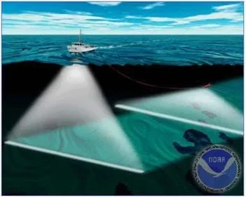 Hull-mounted multibeam sonar (left) and towed side scan sonar (right).Copyright NOAA http://chartmaker.ncd.noaa.gov/HSD/wrecks.html
Concepts
Many technologies have been devised to study ocean floor geology and habitats. Information learned from using these tools helps scientists understand seafloor topography, the geological processes that shape the planet, and habitats that support marine organisms. Understanding the underwater terrain advances our knowledge of the ocean. Making discoveries in the unique marine environment requires technologies that use sound to gather information since little light is present underwater. The seafloor is characterized using underwater sound and acoustical systems, which are usually mounted or towed behind large survey vessels.
Bathymetric Data
Bathymetry surveys are one a common method used to characterize the seafloor. Bathymetry refers to water depth in relation to sea level. Echosounders determine the ocean's depths, or bathymetric data. The echosounder emits sound into the ocean, which travels from the vessel to the seafloor and is reflected back to the vessel. The sound is received and recorded. Seafloor depth is calculated using the travel time of sound and the speed of sound in water. The equation used to determine depth: distance = speed x (time/2).
Echosounders can release multiple sound beams at one time, multibeam, which provide depths for a swath of the ocean's bottom. This technique gathers a lot of information at one time. With this data, oceanographers make maps of the seafloor. Data gathered also helps to identify bottom features such as ridges and shipwrecks, as well as provide important information to boat navigators and fishermen.
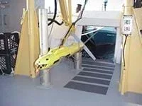 Towed sonar array used by the NOAA ship Rude to perform side scan sonar measurements on the sea floor.Copyright U.S. Geological Survey http://pubs.usgs.gov/of/2004/1003/htmldocs/figures/towfish.htm
Side Scan Sonar
Side scan sonar also uses sound to interpret the topography and bathymetry of the seafloor. The side scan sonar instrument, known as the "fish," releases a sound that is reflected from the seafloor and returns to the fish. The multibeam echosounder uses time to calculate depth. Side scan sonar uses the strength of the returning sound, or acoustical signal, to create an image of the seafloor. The strength of the acoustical signal depends on the shape and texture of the seafloor. For example, hard rock returns a stronger acoustical signal than soft sand. The strength of the signal transmits a light or dark shade onto an image. Oceanographers are able to interpret these images as underground structures, such as volcanoes, canyons and seamounts.
Remote Sensing
Remote = distance, away from source.
Sensing = the process of sensing data and sending the data to a processor, which records the data and interprets the information.
What do you need for remote sensing?
- sensor
- processor
- radiation, light, sound... something to measure
What do we use to measure?
- cameras
- lasers
- radio frequency receivers
- radar systems
- Sonar
An example of remote sensing is provided below; it is an excerpt from, "How Does Satellite Remote Sensing Work?" an article by the Food and Agriculture Organization of the United Nations:
"On board Landsat 5 is a sensor called a thematic mapper. The Earth's rotation below the satellite allows this sensor to scan a new area of the planet's surface with each consecutive pass. The width of the area scanned, called the swath, is 185 km. A full scene is defined as 185 km x 185 km, an area of approximately 34 000 km2, or roughly twice the size of Kuwait.
The thematic mapper detects the solar energy reflected off the Earth's features as well as the Earth's own thermal energy on seven well-defined portions (bands) of the electromagnetic spectrum. For the bands sensing reflected light, the sensor can distinguish spatial features at a resolution of 30 m; meaning features 30 m in size are identifiable. The thematic mapper's thermal channel, however, identifies features at the much lower resolution of 120 m. The energy detected by the sensor is recorded electronically, not on photographic film. The images produced by remote sensing are not photographs.
Because various features on the Earth's surface interact with and reflect solar energy differently in the various bands, the thematic mapper can be used to identify clearly a broad range of elements of land cover. For example, healthy green leaves are excellent reflectors of near-infrared wavelengths. The thematic mapper's fourth band detects reflected energy in this range, so it is particularly useful for identifying and mapping vegetation in a given area.
Data from the thematic mapper are transmitted to stations on the ground. By international agreements, this information must be made available to anyone who requests it."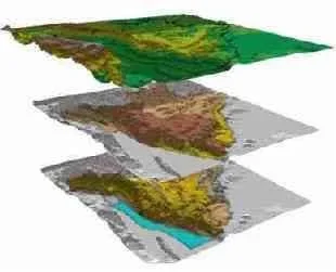 Data from the thematic mapper collected by Landsat 5.Copyright 1999 Food and Agriculture Organization of the United Nations http://www.fao.org/english/newsroom/highlights/1999/9911rs-e.htm
Exploring the Ocean Floor with Satellite Altimeter Data:
- Geosat satellite was launched by the U.S. Navy in 1985 and orbits the earth 14.3 times per day.
- Tiny bumps and dips in the ocean basin can be measured using a very accurate radar mounted on a satellite.
- The satellite-derived measurements can be compared and combined with measurements made by ships.
- Confirmation of the theory of plate tectonics.
- Spreading ridges are characterized by a pattern of ridges and transform faults.
- Calilbration by depth soundings.
- Other application of remote sensing:
People other than oceanographers find sea surface temperature maps useful. Swimmers can use these maps to decide which beach has water temperature that is "just right." The food that fish feed on tends to get trapped where warm and cold water meet, so fisherman use SST images to determine where to drop their nets. The U.S. Coast Guard uses these maps for search and rescue operations to determine how cold the water is where someone has gone missing so they cam estimate how long a person could survive before succumbing to hypothermia.
What else is bathymetry used for?
- currents
- tides
- mixing and upwelling
- seamounts
How do we study what we cannot see or touch? How would you make a map of the seafloor? What is the seafloor terrain like? What plants and animals live in the depths of the ocean? (Listen to student ideas.)
Research in marine science is more complex than terrestrial research. Limitations of humans to explore underwater have made it difficult to study animals, habitats and their interactions. Current technological innovations by engineers enable scientists to further understand and apply information about animal locations and habitat. Remote sensing and exploration with underwater vehicles give scientists tools to map and understand the seafloor, and in some cases, the water column. Geographic information systems (GIS) help us to manage and view spatial relationships/mapping.
Let's take a look at what technology has been able to uncover. (Show students GIS images of the ocean bathymetry and possibly GIS-animated clips, or flythroughs, to engage and familiarize them to the subject. This helps students to learn how GIS works as well as the importance and application of habitat mapping). Following the lesson students can explore the associated activity Map That Habitat to learn more about seafloor geography and bathymetry mapping.
- remote sensing
- The process of detecting and monitoring physical characteristics of an area by measuring its reflected and emitted radiation and without physically contacting the object.
- habitat
- The area or environment where an organism or ecological community normally lives or occurs.
- spatial location
- Where an object or animal is located in space.
- latitude
- The angular distance north or south of the Earth's equator, measured in degrees along a meridian, as on a map or globe.
- longitude
- Angular distance on the Earth's surface, measured east or west from the prime meridian at Greenwich, England, to the meridian passing through a position, expressed in degrees (or hours), minutes and seconds.
- side scan sonar
- Technique of sending a sound via an instrument in which the sound is reflected from a target object. The return time is used to calculate depth or distance to the target.
- sonar
- Technique of sending a sound wave through a space and recording how long it takes for the sound to bounce off as object and return again; used to determine distances or depths.
- soundings
- Measuring water depth using a weighted rope.
- bathymetry
- The measurement of the depth of bodies of water.
- satellite
- A manufactured object or vehicle intended to orbit the earth, the moon, or another celestial body.
- Engage students in a discussion to gauge their knowledge of oceanographic data collection, bathymetry and mapping. Ask inquiry-based, open-ended questions about not only how we do this, but why?
- Did students gain an understanding of the importance of remote sensing technologies and mapping?
An example of seafloor topography at this NOAA website: http://www.ngdc.noaa.gov/mgg/mggd.html
U.S. Geological Survey: http://www.usgs.gov/
More information on remote sensing using satellites: http://www.coolclassroom.org/whats_cool/remotesensingsat.html
Satellite Altimeter Data & Use. NOAA. Accessed July 9, 2004. http://www.ngdc.noaa.gov/mgg/bathymetry/predicted/explore.HTML#sat_alt
Swath Bathymetry & Side Scan Sonar. U.S. Geological Survey. Accessed July 9, 2004. http://woodshole.er.usgs.gov/operations/sfmapping/swath.htm
Contributors
Kimberly Goetz; Jonelle Stovall; Melissa Sanderson; Heather Kerkering
Supporting Program
Engineering K-PhD Program, Pratt School of Engineering, Duke University
Acknowledgements
This content was developed by the MUSIC (Math Understanding through Science Integrated with Curriculum) Program in the Pratt School of Engineering at Duke University under National Science Foundation GK-12 grant no. DGE 0338262. However, these contents do not necessarily represent the policies of the NSF, and you should not assume endorsement by the federal government.
Copyright
2013 by Regents of the University of Colorado; original © 2004 Duke University