
Marine Animal Tracking
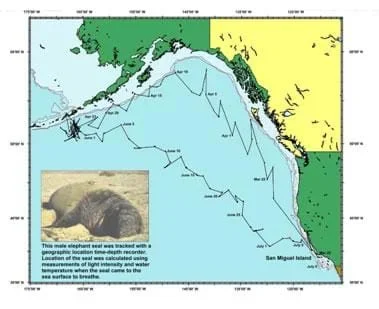 Data tracking the movements of an elephant seal over three months.Copyright NOAA http://www.afsc.noaa.gov/nmml/education/science/studymmsealexample.php
Students are introduced to the ideas and implications of animal tracking, which is useful within scientific and commercial industries. For instance, when planning coastal area development, it is important to take into consideration animal presence and movement. Students are engaged in an activity to monitor animal foraging behavior on a spatial scale by working in groups to track each others' movements as they travel a pre-determined course. They record their results individually and collaboratively in an attempt to understand animal movement regarding foraging behavior. Students also engage in a creative design activity, focusing on how they would design a tag for a marine animal of their choice. To conclude, students are questioned about data interpretation and how spatial information is important in relation to commercial, conservation and scientific research decisions.
The presence and behavior of animals figures into the research and decision making of engineers involved in the commercial development of coastal areas. The creative design activity provides students the opportunity to think like engineers in developing a remote sensing tag that could be used for marine animal tracking and data collection.
- To be able to explain how animal habitats are mapped in the marine environment.
- To be able to identify current technologies employed in mapping resources.
- To collect, interpret and apply data related to the mapping of a marine habitat.
- To gain skills in designing research technology, specifically tag design.
- CCSS.Math.Content.5.MD.B Represent and interpret data.
Grade 5
Do you agree with this alignment?
- Technological systems can be connected to one another.
Grades 6-8
Do you agree with this alignment? - Information and communication systems allow information to be transferred from human to human, human to machine, and machine to human.
Grades 6-8
Do you agree with this alignment? - STEL-2R Compare how different technologies involve different sets of processes.
Grades 6-8
Do you agree with this alignment? - STEL-7S Create solutions to problems by identifying and applying human factors in design.
Grades 6-8
Do you agree with this alignment?
- DCI.LS2.C.6-8.3 Biodiversity describes the variety of species found in Earth's terrestrial and oceanic ecosystems. The completeness or integrity of an ecosystem's biodiversity is often used as a measure of its health.
Grades 6-8
Do you agree with this alignment?
- CCSS.Math.Content.5.MD.B Represent and interpret data.
Grade 5
Do you agree with this alignment?
- 5.L.2.3 Infer the effects that may result from the interconnected relationship of plants and animals to their ecosystem.
Grade 5
Do you agree with this alignment? - 8.E.1.2 Summarize evidence that Earth's oceans are a reservoir of nutrients, minerals, dissolved gases, and life forms:
- Estuaries
- Marine ecosystems
- Upwelling
- Behavior of gases in the marine environment
- Deep ocean technology and understandings gained
Grade 8
Do you agree with this alignment?
It is helpful if students have completed the associated lesson, Habitat Mapping, in order to aid in their understanding of animal tracking.
- Concepts of animal mapping/tracking in the marine environment.
- Current technologies employed in mapping resources.
- Process of data collection, interpretation and application.
- Designing research technology.
Animal tracking has many implications. The data collected might be used for commercial, conservation or scientific research. Industrially, animal tracking data is used by fishing and ecotourism industries as means to locate marine organisms. Conservation organizations also rely on tracking data to determine animal spatial movements, thus influencing locations of urban development. Tracking data is frequently collected by researchers to gain knowledge of animal behavior such as migration between foraging, breeding and nursery grounds.
Tagging: Scientists can learn a lot by tagging marine animals! Tagging animals provides information on their population size, migration patterns and favorite habitats. A variety of tagging methods are available.
Satellite tags are small tags attached to marine animals in order to study their movement and migration patterns. Satellite tags are generally used to study larger animals, such as marine mammals, tuna and sharks. A satellite tag, which can fit in your hand, relays signals through satellites. This data is obtained by data systems on the ground. Battery life determines the quantity and quality of data received from the tag. Battery life decreases with each data transmission. Information relayed includes time, date, latitude, longitude, dive depths, dive durations and surface times. Two types of tags exist. The pop-up satellite archival tag transmits all the data at one time, when the battery dies. The other type collects data while the animal is underwater and then transmits this data by antennae when it surfaces. Satellite tags can last from a few days to many months. Satellite tagging provides crucial information at a high cost; one tag can cost ~$3,500.
WhaleNet uses satellite transmitters that send signals to satellites maintained by the ARGOS (Advanced Research and Global Observation Satellite) System in Largo, MD, and Talouse, France. A number of the U.S. National Oceanographic and Atmospheric Administration's (NOAA) weather satellites, circling the Earth, have instruments attached. These instruments collect, process and disseminate environmental data relayed from fixed and mobile transmitters worldwide. What makes this system unique is the ability to geographically locate the source of the data anywhere on the Earth.
Archival tags are small tags implanted or attached to a marine animal. These tags record information such as depth, light, water temperature and internal body temperature. They can even record the heart rate and the swimming speed of some marine mammals. Archival tags are unique because they provide information about the oceanographic environment in which the animal is traveling. This information is important for determining how changing oceanic conditions relate to animal behavior, movement patterns and physiology. Although archival tags provide essential information, the data can only be obtained when the tag is recovered. For this reason, researchers tend to study animals with either a predictable movement pattern or animals likely to be caught again in fisheries, such as fish and sharks.
Tag-a-Giant in California: Researchers from Stanford and Duke University along with the Monterey Bay Aquarium and National Marine Fisheries Service have placed more than 700 electronic tags in bluefin tuna in this region. The data from implantable archival tags has been critical for establishing the basic biology of Atlantic bluefin and the patterns of movements to feeding and breeding grounds.
Research in marine science is more complex than terrestrial research. Human limitations to underwater exploration have historically made it difficult to study marine animals, habitats and their interactions. New technological innovations are enabling researchers to better understand and apply information about animal locations and habitat. Scientists are tagging bluefin tuna, sharks, turtles, molas (sunfish), seals, cetaceans, albatross, squid and other fish to understand the animals' movements and interactions with their habitats through mapping over time. Engineer-designed geographic information systems (GIS) aid in the management, viewing and analylsis of spatial relationships and mapping of the collected data.
(Explain the importance of habitat mapping and inform students that they have the opportunity to map each other's movements after the lesson. Then discuss some technologies used to track animals, showing some pictures of various examples of tracking equipment). Folowing the lesson conduct the associated activity Acting Out Animal Tracking: Map-a-Buddy to introduce the concept of tracking the spatial movements of animals in relation to the environments in which they live.
- spatial location
- Where an object or animal is located in space.
- latitude
- The angular distance north or south of the Earth's equator, measured in degrees along a meridian, as on a map or globe.
- longitude
- Angular distance on the Earth's surface, measured east or west from the prime meridian at Greenwich, England, to the meridian passing through a position, expressed in degrees (or hours), minutes and seconds.
- tracking
- To observe or monitor the course of (animal, for example), as by radar.
- sensor tag
- Technology used to log data on a range of environmental and behavioral parameters.
Engage students in a discussion regarding knowledge on animal tracking & mapping. Ask open-ended questions about not only how we do this, but why?
Did students gain an understanding on the importance of animal tagging, tracking and mapping?
- Students will be able to define the types of tags used for animal tracking.
- Students will be able to discuss why tagging technologies are important for species conservation.
Were students able to draw final conclusions regarding foraging and/or migratory behavior and the collection and use of spatial data?
As an added activity, have students design a marine animal tag on a sheet of paper. Require students to explain what type of technology is needed for the tag based on the environment. In addition, have students take into account how the tag will be attached to the animal and its possible effects.
Bring in a stuffed manatee, dolphin or turtle, and have students design tracking devices to fit on the model. This could be as simple as cutting out the aforementioned sketches and securing them with tape. Bolster this by demonstrating how the animal moves through water, or if they swim near to reefs or mangroves.
Main page for tagging of large marine pelagics: http://www.tunaresearch.org/
WhaleNet Resources. Accessed July 14, 2004. http://whale.wheelock.edu/Students.html
- Marine Mapping
- Habitat Mapping
- Marine Animal Tracking
Contributors
Kimberly Goetz; Jonelle Stovall; Melissa Sanderson; Heather Kerkering
Supporting Program
Engineering K-Ph.D. Program, Pratt School of Engineering, Duke University
Acknowledgements
This content was developed by the MUSIC (Math Understanding through Science Integrated with Curriculum) Program in the Pratt School of Engineering at Duke University under National Science Foundation GK-12 grant no. DGE 0338262. However, these contents do not necessarily represent the policies of the NSF, and you should not assume endorsement by the federal government.
Copyright
2013 by Regents of the University of Colorado; original © 2005 Duke University