
Using Map Scales to Figure Distances and Areas
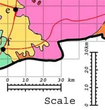 Students use map scales to determine map distances and areas,Copyright 2005 Adventure Engineering, Colorado School of Mines
Continuing the Asteroid Impact challenge, students learn how to determine map distances and areas using map scales. They get a feel for how much an area represents on a map in relation to the sizes they are suggesting for their underground caverns to shelter the Alabraska population.
Many types of engineers—civil, geological, petroleum, environmental—must fully understand maps, map reading and map creation to assist in the research and planning of engineering design solutions, such as designing roadways and tunnels, drilling for water or fossil fuels, creating dams, and tracking air pollution.
After this activity, students should be able to:
- Use a map scale to determine distances between cities on a map and the size of areas on a map.
- Compare map areas determined in this activity to areas from a previous activity.
- Relate map areas and lengths to a real-world situation.
- 6.1.2.b Fluently add, subtract, multiply, and divide multidigit decimals using standard algorithms for each operation.
Grade 6
Do you agree with this alignment? - 7.4.1.a.i Solve problems involving scale drawings of geometric figures, including computing actual lengths and areas from a scale drawing and reproducing a scale drawing at a different scale.
Grade 7
Do you agree with this alignment?
- Analyze and interpret data identifying ways Earth's surface is constantly changing through a variety of processes and forces such as plate tectonics, erosion, deposition, solar influences, climate, and human activity
Grade 5
Do you agree with this alignment? - Develop and communicate an evidence based scientific explanation around one or more factors that change Earth's surface
Grade 5
Do you agree with this alignment? - Gather, analyze, and communicate data that explains Earth's plates, plate motions, and the results of plate motions
Grade 7
Do you agree with this alignment?
- CCSS.Math.Content.6.NS.B.3 Fluently add, subtract, multiply, and divide multi-digit decimals using the standard algorithm for each operation.
Grade 6
Do you agree with this alignment? - CCSS.Math.Content.7.G.A.1 Solve problems involving scale drawings of geometric figures, including computing actual lengths and areas from a scale drawing and reproducing a scale drawing at a different scale.
Grade 7
Do you agree with this alignment?
- Requirements for design are made up of criteria and constraints.
Grades 6-8
Do you agree with this alignment? - STEL-7J Evaluate designs based on criteria, constraints, and standards.
Grades 3-5
Do you agree with this alignment? - STEL-8M Use instruments to gather data on the performance of everyday products.
Grades 6-8
Do you agree with this alignment?
- MS-ESS2-2 Construct an explanation based on evidence for how geoscience processes have changed Earth's surface at varying time and spatial scales.
Grades 6-8
This resource focuses on the following Three Dimensional Learning aspects of NGSS:
Science & Engineering Practices- Construct a scientific explanation based on valid and reliable evidence obtained from sources (including the students' own experiments) and the assumption that theories and laws that describe the natural world operate today as they did in the past and will continue to do so in the future.Do you agree with this alignment?
Disciplinary Core Ideas- The planet's systems interact over scales that range from microscopic to global in size, and they operate over fractions of a second to billions of years. These interactions have shaped Earth's history and will determine its future.Do you agree with this alignment?
- Water's movements—both on the land and underground—cause weathering and erosion, which change the land's surface features and create underground formations.Do you agree with this alignment?
Crosscutting Concepts- Time, space, and energy phenomena can be observed at various scales using models to study systems that are too large or too small.Do you agree with this alignment?
Do you agree with this alignment? - Construct a scientific explanation based on valid and reliable evidence obtained from sources (including the students' own experiments) and the assumption that theories and laws that describe the natural world operate today as they did in the past and will continue to do so in the future.
- rulers, meter sticks, measuring tapes
- calculators
- 4 handouts: Scaling the Map Worksheet (PDF), Alabraska General Map (PDF), Alabraska Geology Map (PDF), Reference Page (PDF) (vocabulary, formulas, unit conversions)
- (optional) a large-sized Alabraska General Map (PDF), 2 x 3 ft (.6 x 1 m), for display in the classroom; alternatively, use a projector to enlarge and display the map
Some knowledge of length, width, area and volume; multiplication.
Now that your engineering team knows the required cavern area, your task is to translate that information to a map to see how big the cavern is compared to the size of the state of Alabraska.
Background
As necessary, refresh students' knowledge on how to use map scales.
Before the Activity
- Gather materials and make copies of the handouts.
- Post (or project) the large-sized Alabraska General Map (PDF) at the front of the classroom.
With the Students
- Hand out the materials to the groups.
- Re-familiarize students with the maps by asking them a few questions, for example: What is the capitol of Alabraska? Where is it located in terms of grid coordinates? What types of transportation are represented in the state of Alabraska?
- Discuss the map scale with students. Lead them through some examples by making map measurements with a ruler and then determining how many miles this represents according to the map scale. For example, if 1 centimeter = 10 kilometers, then 3 cm on the map represents 30 kms in the real world.
- Give the engineering teams time to complete the worksheet. Tips for worksheet questions:
Q1: To put the worksheet answers into perspective, ask students to compare their answers to their own home-to-school distance.
Q2:The grid space area is determined by multiplying length by width.
Q3: Expect students to figure out that they can count grid spaces within the military base and multiply by the area per grid space (Q2 answer).
Q4: This is to give the students perspective.
Q5: Expect students to find that Alabraska is much bigger than the required cavern area.
- As time permits or assign as homework: If students drew plans of their cavern designs at the end of the previous activity, now have them re-draw them to scale. An appropriate scale is 1 cm = 1 km.
Worksheet: Review students' answers on the Scaling the Map Worksheet (PDF)to gauge their mastery of the subject matter. Refer to the Asteroid Impact Student Workbook Example Answers provided in the unit document for example worksheet answers.
Quiz: To conclude, ask students to estimate distances using a different map. For example, estimate the distance from two cities such as London and Moscow, or the area of a U.S. state. Or have students conduct the Extension Activities.
Homework: If students drew plans of their cavern designs at the end of the previous activity, now assign them re-draw them to scale. An appropriate scale is 1 cm = 1 km.
- On a map of the U.S., use the scale to determine the area of any state.
- Find the largest country in the world and use the scale to determine its size.
- What are the tallest buildings in the world? For example, the Willis Tower in Chicago is 1,450 feet tall (110 floors). If you were asked to build a model of this skyscraper at a scale of 1 inch = 100 feet, how tall would the model be? (Answer: 14.5 inches tall.) For extra credit, convert English units to metric units (442 meters).
- Adventure Engineering Challenge: Asteroid Impact
- Incoming Asteroid! What's the Problem?
- How Big? Necessary Area & Volume for Shelter
- Using Map Scales to Figure Distances and Areas
- Identifying Possible Underground Cavern Locations
- Rocks, Rocks, Rocks: Test, Identify Properties & Classify
- Ranking the Rocks for Desired Properties
- Recommendations & Presentations: Drum Roll Please
- Building & Testing Model Underground Safety Caverns
Supporting Program
Adventure Engineering, Colorado School of Mines
Acknowledgements
Adventure Engineering was supported by National Science Foundation grant nos. DUE 9950660 and GK-12 0086457. However, these contents do not necessarily represent the policies of the National Science Foundation, and you should not assume endorsement by the federal government.
Copyright
2013 by Regents of the University of Colorado; original © 2005 Colorado School of Mines