
Where Are the Plastics Near Me? (Field Trip)
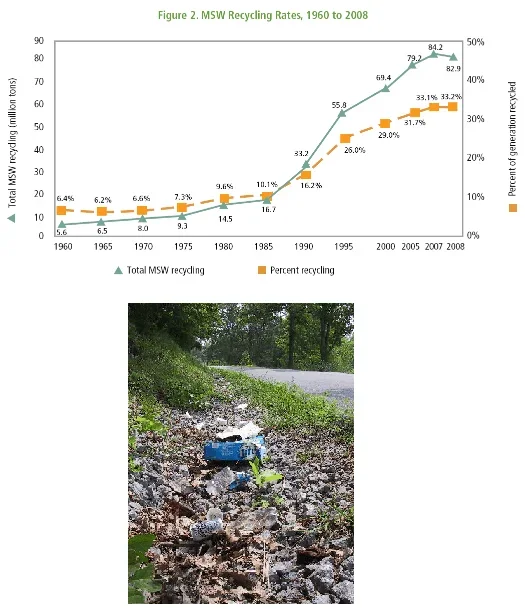 Figure 1. (bottom) Discarded roadway trash includes plastics that will never degrade. (top) U.S. recycling rates, 1960 to 2008, of municipal solid waste (MSW), which includes all trash from residences and many kinds of commercial businesses. Though the overall recycling rate has increased dramatically since 1960, much plastic is still not recycled and finds its way to waterways.Copyright (bottom) Environmental Education Station {PD} http://web.centre.edu/enviro/Photos_files/photolib_files/pollutionpics.htm (top) U.S. EPA report on US MSW in 2008 {PD} [1]
Through an adult-led field trip, students organized into investigation teams catalogue the incidence of plastic debris in different environments. They investigate these plastics according to their type, age, location and other characteristics that might indicate what potential they have for becoming part of the Great Pacific Garbage Patch (GPGP). Students collect qualitative and quantitative data that may be used to create a Google Earth layer as part of a separate activity that can be completed at a computer lab at school or as homework. The activity is designed as a step on the way to student's creation of their own GIS Google Earth layer. It is, however, possible for the field trip to be a useful learning experience unto itself that does not require this last GIS step.
Field work is one aspect of environmental engineering. Environmental engineers collect samples of various media for chemical and biological analysis and make observations about the conditions in which those samples were found. Students in this activity collect environmental samples in the form of photographs of plastics contamination and execute a sampling plan designed by the teacher. Like engineers, they form their own theories for the source, fate and transport of what they find. They also need to be vigilant that the quality and usefulness of the data is high, just as practicing environmental engineers do.
After this activity, students should be able to:
- Take observational notes on field surroundings.
- Read and understand latitude and longitude coordinates from a handheld GPS device.
- Discern what kind of information is valuable to be gathered in the field.
- Determine what kinds of plastics are found disposed on land in a survey area and speculate reasons as to why they are there and their fate.
- Explain how environmental engineers use similar data collections to analyze highly concentrated areas of various types of pollution.
- The management of waste produced by technological systems is an important societal issue.
Grades 6-8
Do you agree with this alignment? - STEL-4L Analyze how the creation and use of technologies consumes renewable and non-renewable resources and creates waste.
Grades 6-8
Do you agree with this alignment? - STEL-8J Use devices to control technological systems.
Grades 6-8
Do you agree with this alignment?
- MS-ESS3-4 Construct an argument supported by evidence for how increases in human population and per-capita consumption of natural resources impact Earth's systems.
Grades 6-8
This resource focuses on the following Three Dimensional Learning aspects of NGSS:
Science & Engineering Practices- Conduct an investigation to produce data to serve as the basis for evidence that meet the goals of an investigation.Do you agree with this alignment?
Disciplinary Core Ideas- Typically as human populations and per-capita consumption of natural resources increase, so do the negative impacts on Earth unless the activities and technologies involved are engineered otherwise.Do you agree with this alignment?
Crosscutting Concepts- All human activity draws on natural resources and has both short and long-term consequences, positive as well as negative, for the health of people and the natural environment.Do you agree with this alignment?
- Technologies extend the measurement, exploration, modeling, and computational capacity of scientific investigations.Do you agree with this alignment?
Do you agree with this alignment? - Conduct an investigation to produce data to serve as the basis for evidence that meet the goals of an investigation.
- Earth and space. The student knows that natural events and human activity can impact Earth systems. The student is expected to:
Grade 7
Do you agree with this alignment? - design and implement experimental investigations by making observations, asking well-defined questions, formulating testable hypotheses, and using appropriate equipment and technology;
Grades 6-8
Do you agree with this alignment? - collect and record data using the International System of Units (SI) and qualitative means such as labeled drawings, writing, and graphic organizers;
Grades 6-8
Do you agree with this alignment? - analyze data to formulate reasonable explanations, communicate valid conclusions supported by the data, and predict trends.
Grades 6-8
Do you agree with this alignment?
Each group needs:
- handheld GPS device (if possible)
- digital camera
- extra batteries for GPS and camera
- field-ready (durable) notebook and pen
- ruler or tape measure
- printouts of a few aerial photos (obtain from Google Earth); if handheld GPS devices are available, then these aerial photos are recommended but not required
- plastic bag or satchel, to contain all supplies in this list
- (optional) snacks and drinking water
It is well known that many of the plastics that are contained in the Great Pacific garbage patch (GPGP) come directly from land-based littering that eventually runs off into local streams and then moves into the oceans.[2] If this is so, the connection between us and the GPGP thousands of miles away often begins on the ground near a local waterway. It should be possible to find plastics near streams, creeks, rivers and lakes in our area and describe and quantify them. Thus, as if we were environmental engineers figuring out how to better solve the GPGP problem, we will take a field trip to better understand the sources of the problem.
We will attend one or more sites where plastics can be examined and use these techniques to quantify and describe what we find. The goal is to act as environmental engineers as we answer the following questions through field investigation: What kinds of plastics are in our area? What are the states of these plastics? Are they pristine, mangled, partially degraded, extremely aged, etc.? How large are these plastics? Are they plastics from the same general sources (such as restaurants), or from many different sources? Do they concentrate in one particular area? If so, why is that? What are the exact locations of these plastics? Is it likely that these plastics will move? How would that happen, and are they likely to enter our local water bodies?
Environmental engineers use two primary techniques to describe their observations: qualitative or quantitative. Qualitative techniques describe what we find in terms of words rather than numbers. They answer questions of general condition such as color or physical description either of the plastics themselves or the location in which they are found. Quantitative techniques allow some kind of number or quantity to be assigned to the debris that we examine. In this field trip, the main quantities that are valuable are size, count and geographic coordinates. You have been given all of the supplies you need for both qualitative and quantitative descriptions.
When you go to a site, find at least five examples of plastics or other critical pollution debris. Take at least one and no more than three digital photographs of each one, and record the following data to thoroughly document the photographs.
- Picture ID: Assign ID for the picture that matches the one used in the digital camera so that you can later match it with your notes. Your camera automatically assigns an ID that you can simply record from the screen.
- Written Description: Write one to five sentences that describes what is in the picture. In terms of physical description, include information on color, labeling (brands, companies, etc.), material (Styrofoam, polyethylene bag, hard thermoplastic), and condition (smashed flat, half buried, chewed on by animal, ripped) Also, you may wish to write down information on the transport and fate of the plastic. Answer questions such as: "How did this plastic get here?" "How long has it been here?" and "How long will it remain?"
- Direction: Use a compass on the GPS device, an arrow compass or landmarks to determine and document in what direction each photo is taken. Pictures that are taken from above do not need a directional heading. If a NESW heading cannot be easily determined, describe it in terms of landmarks (such as "towards the bridge" or "looking downstream") so that heading directions can be determined later from these general descriptions.
- Geographic Coordinates: Stand directly over the trash item, wait for the GPS unit to stabilize, and record the coordinate in the notebook. Make sure to get two coordinates, one for x and one for y. Most likely the coordinates will be in latitude and longitude, but you may also see them in Easting and Northing such as in the UTM system. Record whatever the unit gives you and figure the coordinate system later if not already known. If GPS units are not available, use landmarks to approximate your position and mark it on an aerial photograph. Be as accurate as you can, and put the picture ID near your mark so that marks are not confused.
- Trash Dimension: Use the tape measure to record one or more dimensions of the plastic objects (height, length, and/or width). Any units are fine as long as they are consistent for all measurements made.
- Photograph Dimension (only when necessary): If you are unable to get close enough to an item to get an exact coordinate (such as if it is half submerged in water), record a coordinate or position from where the picture is taken. Then estimate the distance that you are away from the piece of trash in the photograph.
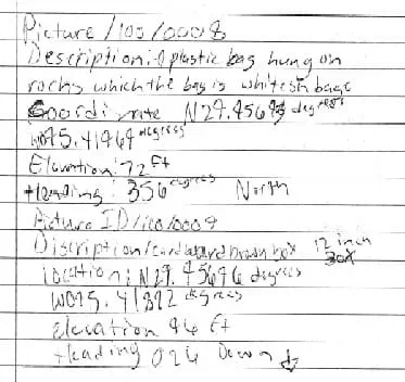 Figure 2. Student field note excerpt for two pictures that were taken near Greens Bayou in Houston, TX. This example includes complete coordinates, compass heading, elevation, dimensions on a box that was found, and a written description to accompany the photograph.Copyright 2010 Nathan L. Howell, GK-12 Program, College of Engineering, University of Houston
Before leaving a site, be sure to write down GENERAL OBSERVATIONS about the location to go with a site's set of photograph. Here is an illustrative example.
- The site of our photographs encompasses an area focused on where 21st street crosses over Lonely Creek. The debris extends about 50 feet downstream of the bridge and 85 feet upstream of the bridge. The major examples of plastic were found on the right bank when looking downstream or were in the water, and most were within 30 feet of the bridge itself. The creek is fairly shallow and widens out under the bridge where it (the water velocity) gets faster. The banks are very steep in the flood plain area that extends about 150 feet either side of the creek. It looks like the creek left its banks and went about 40 feet into the flood plain during the last storm 5 days ago. Very tall weeds and grasses on the right bank tcatch and hold many plastic items.
As a general guideline, it is best to record as much information about each example of plastic as you can and about the land/water/vegetation near it. It may only become clear what is most important when you later go back to examine all of the field information. At that point, it will be too late to take more notes, and your memory may not accurately recall what you saw.
When the data collection field trip is over we will, on another day, put it together an interesting and geographic way that teaches you and shows others about the locations of local plastics garbage.
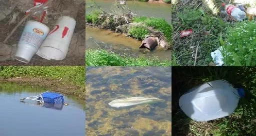 Figure 3. Examples of trash, plastics and conditions along Greens Bayou in Houston, TX. Note how some pictures are directed straight downward at a sampler's feet while others were taken at a distance and will need to be recorded as such in field notes. Pictures collected in March 2010.Copyright 2010 Nathan L. Howell, GK-12 Program, College of Engineering, University of Houston
Before the Activity
- Obtain enough GPS units for every team, if possible, and familiarize yourself with use of the compass and coordinate features; explain them to students. Most GPS devices permit users to change the display to their needs. The easiest coordinate structure to use (if plotting coordinates on a map later is what is desired) is the World Geodetic System 1984 (WGS84) with latitude and longitude with the lat-longs displayed in decimal degrees (looks like: 41.850125° -87.650300°, decimal degrees, rather than 41°51'0.12"N 87°39'0.19"W, degrees minutes seconds, coordinates for Chicago). Either system coordinate type readily searches in Google Earth, but decimal degrees are in general more versatile. Note that if, for any reason, latitude and longitude coordinates are obtained as degrees minutes seconds, a simple equation can be used to convert them to decimal degrees. Decimal degrees = (-1 if south or west)*(degrees + (minutes/60) + (seconds/3600)
- Visit the site(s) where the plastic searching will be conducted. Check for safety hazards such as steep embankments, holes, electrical equipment, construction activities, animals and vagrants. Also make certain that it is a location that provides a good example of plastic and other interesting debris. If possible, obtain coordinates while there, and note where to park, where to have an on-site discussion, how to limit the extent of searching, and an exit strategy if a storm or other weather hazard suddenly appears. It also is a good idea to use most of the equipment (camera, GPS, tape measure) at the site to make sure that everything will work as intended when the students arrive. Note that for site selection, this activity is written more in terms of near-stream, near-lake type environments. However, it really does not matter if it is right next to a water body. As long as plastics are present that can be catalogued, the educational experience will be valuable. Discussions and project ideas can be held just as well in an open field as along a creek; they will simply be on slightly different site-related topics. It is recommended to use four or five different sites so that different kinds of conditions are observed. However, more or less than this can be easily accommodated.
- Know which students to select to bring on the trip. It may be valuable to not bring an entire class if not all students are mature enough to be safe, work while in the field, and take care of equipment. Participation in the trip can be a motivational tool for a class, a reward given only to those who behave well and do good work.
- Prepare an aerial photo for every site on the schedule, which is fairly easy to do using screen shots from Google Earth. Aerial photos or some other form of detailed feature map is REQUIRED if GPS are not available so that students can determine coordinates once back at a Google Earth-enabled computer.
- Group all supplies (GPS, camera, tape measure, maps, notebooks, pens, etc.) into large plastic bags or satchels for each student group. This way, the supplies can easily be handed out to group leaders.
- If possible, obtain and at least one extra of every piece of equipment in case something fails.
- Discuss equipment operation, safety and trip logistics with all teachers and chaperones attending the field trip. The trip works best if each student group can be accompanied by an adult. That adult needs to know how to guide each student group on technical issues ranging from equipment to the plastic waste being studied.
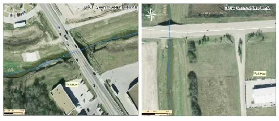 Figure 4. Example field maps for two locations in Greens Bayou in Houston, TX. Though these maps were created with ESRI ArcGIS® software, a very similar map could be created in Google Earth.Copyright 2010 Nathan L. Howell, GK-12 Program, College of Engineering, University of Houston. Images generated in ESRI ArcGIS® software.
With the Students
- At school, divide the class into groups of three or four students each, and have them remain with each other for the entire duration of the field trip.
- Take everyone in vehicles (or on foot if near the school) to the first/only site. At that site, review the goals of the field activity, safety and logistics. Then demonstrate the use of all equipment and note-taking procedures for one or two pieces of trash. Answer all student questions and quiz groups on various aspects to make sure they know what they are doing.
- Assign no more than two groups to each chaperone (one per group is best) and release groups to collect photo-based observations on five pieces of (preferably plastic) related trash. Have adult accompaniment help in collection, and ask questions about what the students are observing and discussing during the data collection. For coordinate note-taking especially, make certain that all student groups correctly write down GPS coordinates, from the very first item logged. Record the coordinates in latitude and longitude in decimal degrees WGS84. If coordinates are recorded incorrectly or only one coordinate is recorded, later mapping efforts will not be possible.
- When each group has finished site photography and note taking, direct them to make general site notes for a few minutes, similar to the example given above.
- Move on to the next site and continue with the activities until data has been collected at all sites. If only a small number of sites (1-2) are being used, then it may be better to instruct students to fan further out at the site(s) and get more than five observations so that more data is collected overall.
- When data collection is complete, be sure that students record group member names in their notebooks as well as CAMERA IDs. If cameras and notebooks are not matched, then matching photographs to descriptions will be unclear. Collect all equipment and data records from student groups for later use.
- great pacific garbage patch
- A mass of floating debris, mostly plastic, in the Northwest Pacific Ocean that spins around central point. It is hundreds to thousands of miles long, floats just below the surface, and extends to a depth of about 10 meters.
- environmental fate and transport
- Refers mainly to environmental contamination by biological (bacteria viruses), chemical (pesticides, metals, nutrients), or physical (trash, sediment) means. Fate and transport is concerned with the question of how is the contamination moving and going to move in an environment (transport) and where will it ultimately go or be transformed into (fate).
- qualitative data
- Data of a descriptive or categorical nature. Examples: salty/sweet in taste or male/female.
- quantitative data
- Data that is expressed as some form of numerical quantity. Often but not always given with an estimate of precision. (such as 5 ± 0.25 inches)
- easting
- Refers to UTM and other similar coordinate systems (such as State Plane). The measurements in the system that are east and west. Because these systems are generally Cartesian (orthogonal) rather than spherical, the units of the coordinates are actual measures of length (feet, meters).
- northing
- Refers to UTM and other similar coordinate systems (such as State Plane). The measurements in the system that are north and south. Because these systems are generally Cartesian (orthogonal) rather than spherical, the units of the coordinates are actual measures of length (feet, meters).
- world geodetic system 1984
- A standard coordinate system that uses the 1996 Earth Gravitational Model geoid and is referenced to the center of the Earth. Coordinates are given as latitude and longitude though the "prime meridian" used is slightly different from the classic Prime Meridian through Grenwich. Abbreviated as WGS84.
Pre-Activity Assessment
Option 1- Short Quiz/Survey: Write a short quiz or survey to assess how much students know or have experience with plastics or field work like this using the procedure as described above as source material for questioning.
Option 2 - Garbage Patch Newsletter: If your students have completed the GPGP newsletter assignment, then assess their plastics understanding based on that.
A note on selectivity: Since the logistics may not allow all students to attend, it may be wise to determine what student should be able to attend the field trip using Options 1 or 2 or some other related assignment. Participation in the field trip can be competitively based and may be a good source of motivation for students to excel on assignments.
Activity Embedded Assessment
Discussion: Use any and all observations that students make as a moment to teach further using any of the Investigating Questions. Students' answers on these and other questions provide feedback on their understanding. Also, observe how quickly and efficiently teams are working. Those getting quality data in short time and working well together are most likely acquiring the skills listed in the Learning Objectives.
Post-Activity Assessment
Option 1 - Discussion: Obtain feedback on the trip and learning experiences on the drive back to school or shortly after the field trip.
Option 2 - Survey: Design a survey for students to take after they are done rating experience, quizzing them on learning objectives, etc.
Option 3 - Mapping Assignment: A subsequent activity in this unit asks students to take this field trip data and creatively present it in a Google Earth map layer. Students' ability to not just make the layer but put the data together in an informative manner indicates how well they understood the significance of the data they (or their classmates who attended the field trip) were collecting.
- Due to the challenges of safety around water, it is recommended that if this activity is done very close to water that no more than 20 total students be involved.
If you are new with field-based activities, make things simpler. Take fewer students and use fewer sites. Also, spend extra time familiarizing yourself with equipment so that you can deal with issues in the field.
- For lower grades, reduce the workload by requiring fewer sites and pictures, or eliminating some of the data collection requirements. Collect pictures, but no coordinates or eliminate the plastic length measurements.
- For upper grades, increase the difficulty and learning by including the students to some degree in the site selection. If they are adept enough at Google Earth, they can choose sites that will be attended. The teacher could also provide more sites than are necessary and have students investigate (using the teacher's reconnaissance) which would be best for plastics investigation or which are most interesting to them.
Municipal Solid Waste Generation, Recycling, and Disposal in the United States: Facts and Figures for 2008; U.S. Environmental Protection Agency: Washington, DC, November 2009. http://www.epa.gov/osw/nonhaz/municipal/msw99.htm
Marine Debris Program. NOAA. Accessed March 23, 2010. http://marinedebris.noaa.gov/
- Digital Mapping and Geographic Information Systems (GIS)
Contributors
Nathan Howell; Andrey Koptelov
Supporting Program
National Science Foundation GK-12 and Research Experience for Teachers (RET) Programs, University of Houston
Acknowledgements
This digital library content was developed by the University of Houston's College of Engineering under National Science Foundation GK-12 grant number DGE 0840889. However, these contents do not necessarily represent the policies of the NSF and you should not assume endorsement by the federal government.
Copyright
2013 by Regents of the University of Colorado; original © 2010 University of Houston