
What Is GIS?
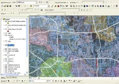 Figure 1. A GIS software screen capture shows roads, hydrography, watershed and sample location (orange dots) layers.Copyright 2010 Nathan L. Howell, NSF GK-12 Program, College of Engineering, University of Houston. Screen capture and distance measurement done in ESRI ArcGIS® software.
Geographic information systems (GIS) are important technology that allows rapid study and use of spatial information. GIS have become increasingly prevalent in industry and the consumer/internet world in the last 20 years. Historically, the basis of GIS was in mapping, and so it is important to understand the basis of maps and how to use them as well as why they are different from GIS. In this lesson, students learn the value of maps, how to use maps, and the basic components of a GIS. They are also introduced to numerous GIS applications.
Engineers are not by nature cartographers, but many types of engineering require gathering, utilizing, analyzing and modeling spatial data. Not only is GIS a good way for engineers to organize data and formulate better project designs, but it serves as an effective tool to communicate ideas to clients and especially the public at large. This is because GIS can be extremely visual as a static figure or as something interactive for varying levels of expertise. In the sphere of technology, this is one type that will be in the toolboxes of many different kinds of engineers, and the study of how to design a better GIS can itself be considered a form of engineering.
After this lesson, students should be able to:
- Identify the most critical parts of any map.
- Describe the static nature of maps (they are only one moment in time).
- Find distances on a map.
- Explain how a GIS is different from a static map.
- Describe the difference between spatial and non-spatial data.
- Describe what geographic layers are.
- Explain how engineers use GIS to solve real-world problems including mapping new territories.
- STEL-1J Develop innovative products and systems that solve problems and extend capabilities based on individual or collective needs and wants.
Grades 6-8
Do you agree with this alignment? - STEL-3G Explain how knowledge gained from other content areas affects the development of technological products and systems.
Grades 6-8
Do you agree with this alignment?
- 6.1.C select tools, including real objects, manipulatives, paper and pencil, and technology as appropriate, and techniques, including mental math, estimation, and number sense as appropriate, to solve problems;
Grade 6
Do you agree with this alignment?
- Earth and space. The student knows that natural events and human activity can impact Earth systems. The student is expected to:
Grade 7
Do you agree with this alignment? - design and implement experimental investigations by making observations, asking well-defined questions, formulating testable hypotheses, and using appropriate equipment and technology;
Grades 6-8
Do you agree with this alignment?
Geographic information systems (GIS) have been in use by industry since the early 1990s and by the general public since the early 2000s. Prime examples of public use GISs are Google Maps [1], Yahoo Maps [7] and Google Earth [5]. To be a GIS, all that is required is some kind of useful spatial information organized onto an interactive map. GIS datasets may be as simple as a few city locations and as complex as thousands of sonar soundings points displayed on a river bottom to give a sense of its bathymetry.
In order for data to be useful in a GIS, normally it has to be linked to location by some kind of coordinate. Data might not be directly linked, but could be linked to a layer that is linked to loations. This property of data relationships makes the structure and thought behind GIS data the same as relational databases. The difference is once again the location. In fact, when a database is linked to a GIS through location it is often called a geodatabase.
All of the components of a paper map are still present in a GIS: direction, scale, legend and source information Often a GIS, is used to make paper maps that may be taken out of the computer lab for field use or for demonstration as a figure. The elements are more "living" when in the GIS. The direction is usually assumed to be north at the top, but it may be different depending on the GIS software and the coordinate system used. For example, since the view in Google Earth is easily rotated, notice that the compass rose on the screen operates in a moveable fashion, much more like a heads up display (HUD) in a fighter jet than a traditional compass rose on a paper map. Scale is usually present in the form of a fraction (for example, 1:1,000, 1:50,000, etc.), but it can be readily changed through zooming. The legend exists as a separate window that shows all of the data layers. These data layers can be altered symbolically and through querying to display selected data as desired in the GIS. The source of the information is usually kept within each data layer in a separate file called the metadata. Most casual users of GIS never view the metadata, but if it is critical to know the data source for a paper map, a note of some sort using a portion of the metadata is placed on the map.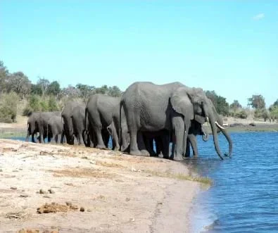 Copyright 2008 Stock.xchng
One of the most unique properties of GIS is that data layers can be combined for various analyses using geography, and even entirely new data layers can be generated by adding, subtracting, clipping and re-sampling multiple layers together. If it were not for this ability in a GIS, then one would need to cut out separate masks of maps to show forests, roads, rivers, etc., and then manually place them one over the other to see how they relate geographically. Before GIS was more common, this is what was done. A common example of this data layer combination is in the African elephant conservation mentioned earlier. A data layer of distance to water and human activity values in Africa presented as a raster has values added on a grid that then generate a new quantity for every grid location. This new value represents the potential risk impact to African elephants. [6]
If I dropped you off in <Denver> (or name a city that is far from students' own community), gave you a driver's license and a car, and gave you the challenge of getting back home on your own, could you do it? How would you do it? (Pick a student or two to answer the hypothetical challenge. Expect students to give various answers, but the main way that a person would do this would be by using a map.) Have you ever used a map before? Have you helped someone navigate roads while driving? Do you know how to read a map?
We're going to consider the possibility of a "magic" map. What makes the map magic you may ask? Watch and see. (Show a video of Harry Potter and the Prisoner of Azkaban with the scene in which Harry is introduced to the "Marauders Map," a magical map that shows the location of every person in Hogwarts and what they are doing in REAL TIME. Or, ask students to recall this map from reading the book or seeing the movie.). So what is it about Harry Potter's map that is magical? (Expect students to answer that the map can be revealed and concealed with magic words, but the more important answer is that the map shows every person, where they are, what they're doing, every minute of every day.) So how are maps today different from Harry Potter's Marauders Map? (Listen to student ideas.) Maps today are static, and they do not show things in real time or things that move about. Think about it. Have you ever seen a map that shows chickens, cats, dogs, cars, boats or people? Why not? These maps do not move. If a map placed a person on a street corner on a city map today, by tomorrow the map would be obsolete. That person isn't going to stay there just because a cartographer marked them there for their map!
So we know that we don't have any magic maps in our world today, but is it possible that we could track someone's location and put it on a "magic" map? What would that map be like? How would we track someone to put them on the map? In fact, we can make digital maps that can change as the information changes. You are probably all familiar with Google Maps. What is it? [1] It is a digital map, and as soon as changes are made at the central Google Maps server, the road, the building, or the restaurant changes. So what about people? People cannot be tracked generally by satellite or aerial photography, but they can be tracked by their CELL PHONE signal. Let me show you a "magic" map that uses that technology. (Open Google Latitude [2], a free service that Google offers to track people (with permission) using their cell-phone signals. You will need to set this up in advance.) Look at the map. Can you see the icon that represents me? Where is that icon? That's right; it is on this very room. If I moved down the street, then it would move with me. You can see that I have a friend who is at another location (have another person with Google Latitude log into it before class) that I can track as well with this "magic" map that is created by engineering technology, not magic.
We've talked about magic maps and technology maps, but how do we really DEFINE a map? You already know the answer intuitively. Check this out. (Present the image of Lower Manhattan at night from an aerial side view. Feel free to pick any other Manhattan image that may be better for a particular class. Many are available. ) What is this place? It is Manhattan. It is a map? Why or why not? But could it be used to help locate some things or navigate? Yes it could be. You could use building landmarks and talk to a person on a cell phone to help him or her find his/her way. But it is missing some things. Here is Manhattan in 1916 [3] (show attached map from University of Texas libraries), and this is definitely a map. What are the things on this map that make it so? They are direction, scale, legend and source of information. Let's try and understand these one by one. (Explain with examples why these pieces of information are critical. As you explain the concept of map scale, pass out the 1916 Lower Manhattan maps and practice finding the distance between map objects with the class using rulers.) Copyright 2006 Hu Totya, Wikimedia Commons http://commons.wikimedia.org/wiki/File:Lower_Manhattan_by_night.jpg
So you might be saying, "Maps are great, but when are we going to learn about the technology part behind all of this, the GIS?" Well it's easier to explain if I show you a video. (Show the ESRI video, "What is GIS?" [4]) So did you see how in the video they were combining different pieces of data together to try and analyze something geographically? (A good example in the video is how traffic accidents and citations seemed to correlate well at common intersections.) Could we then use GIS and the locations of citations to predict where traffic accidents could likely occur next or to decide what intersections need the most adjustment to lower traffic accident rates?
Let's think about data in terms of what can be placed in a GIS. What is it about some data that makes it spatial and other data that makes it non-spatial? The key ingredient is LOCATION. We must have a coordinate, an address, an intersection, a distance from a known point or something that helps us to link the information to a location or set of locations on a map. Without the ability to do that, it is just information, but it is not spatial information. It is not "GISable." (Demonstrate turning layers on and off in a Google Earth [5] window.)
When that information is organized together, we put it into what we call a geographic layer. These layers group common spatial information sets together as a single unit. For example, road networks are a layer that can be turned ON and OFF. In a GIS, layers may be used at some times and removed at others according to need. Other examples are hospitals, schools and even common locations of lightning strikes. You do not have to display all of these at the same time, and if you did it would probably be confusing, but if you use them all together, then it is possible to create a new set of data that tells you something completely different than the individual layers.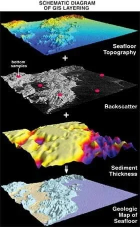 Copyright 2006 U.S. Geological Survery http://pubs.usgs.gov/fs/2006/3042/
Scientists and engineers use GIS to solve real-world problems. Take for example these maps of elephants in Africa done by a GIS researcher. They combined information from two data layers: human activity and distance to water. You can see from the result that places where both human activity and distance to water were high are the locations where elephants are most likely to suffer. Knowing that ahead of time, we can act to try and safeguard elephants in those areas. This is one example of how environmental engineers use GIS to help them gather data to further help them solve a problem!
Review the main lesson points to prepare students for the quiz. For the quiz included with this lesson, key points are 1) an understanding of what makes maps "magic" in Harry Potter and with technology, 2) the main components of any map, 3) the use of a scale on a map, 4) definition of a GIS, and 5) definitions of geographic layers and spatial data. A good way to tie it all together is to illustrate the relationship between data collected, a GIS, and paper maps. Normally the process is that data is collected and processed. Then it is placed into a GIS for analysis. From that analysis, useful maps and figures may be derived that either show results of analysis or provide a map that is useful in the field. Additionally, have students brainstorm other scenarios in which different types of engineers might use GIS to help gather and analyze data. Some examples include determining trends in crop growth, the progress of cleaning up oil spills in the Gulf of Mexico, and mapping the changing ocean floor.
- direction
- Some indication, either given as a direct symbol or text or implied by something in a map that will communicate to the map user the spatial orientation that the map takes. A common example is a compass rose or a north arrow, but a map of the brain can have an implied direction through the use of a facial silhouette. In that case, it is obvious which part of the brain is the front and back because a normal viewer is familiar with faces.
- scale
- A bar or line indicator of some sort on a map that converts the map's paper distance into real world linear distance. Scale can also take the form of areas as well. A scale can also be in the form of a fraction that relates the linear reduction in dimension. Common fractions used by USGS are 1:24,000 and 1:100,000.
- map information source
- Some indication through notes, logo, etc. that tells the map reader who made the map, something about the information in the map, and usually the year of its creation. Without at least a map year, it is difficult to use a map as it is always a static representation of something spatial at one particular moment in time.
- gis
- Stands for Geographic Information Systems. "A geographic information system (GIS) integrates hardware, software, and data for capturing, managing, analyzing, and displaying all forms of geographically referenced information." Definition obtained from www.esri.com. Please see the article there "What is GIS?" for more detailed information.
- spatial information
- Any set of information in prose, tabulated, in a database, or any other kind of median that has some location associated with the information. Locations may be as general as a hand-drawn circle on an aerial photo or as complex as an xyz coordinate with respect to a particular coordinate system. Non-spatial data either has no location given with it, or it is a type of information where it is not possible to give an accompanying location.
- geographic layer
- A set of spatial information that may be displayed in a GIS. Usually the information bits have a common theme to them.
- metadata
- Data that accompanies a geographic layer which gives extra information such as a description, a source, a spatial reference, an author, and a data structure.
- geodatabase
- A database that is used to link information together of a spatial nature. Data layers themselves, directly useable in a GIS, may be part of a geodatabase.
Quiz: Administer the quiz provided with this lesson. Make the quiz easier by changing the questions to multiple choice; make the quiz harder by making the questions more free-form short answer. If you are using this for a technology class, put the quiz online so students can experience the technology and so results can be more easily stored and tabulated..
- Google Earth installation (free to install) [5] at http://www.google.com/earth/download/ge/agree.html
- ESRI's "What is GIS and How Can It Help Me?" video (70 minutes) [4] at http://video.esri.com/watch/81/what-is-gis-and-how-can-it-help-me.
Google Maps. Google Inc. Accessed February 2010. https://maps.google.com/
Google Latitude. Google Inc. Accessed February 2010. https://latitude.google.com/latitude/b/0
Rider, F., Lower End of Manhattan (map). In Rider's New York City Rider, F.; Cooper, F. T.; Hopkins, M. A., Eds. New York, NY: Henry Holt and Company, 1916.
ESRI, What is GIS? Online Flash Video, 2010. http://www.esri.com/apps/esriclips/clip.cfm?ClipID=60
Google Earth 5, Google Inc.: Menlo Park, CA, 2010.
ESRI, Helping Elephants across the African Continent with GIS. GIS Best Practices March, 2009, pp 25-29.
Yahoo! Local Maps. Yahoo! Inc. Accessed March 2010. http://maps.yahoo.com/
Contributors
Nathan Howell; Andrey Koptelov
Supporting Program
National Science Foundation GK-12 and Research Experience for Teachers (RET) Programs, University of Houston
Acknowledgements
This digital library content was developed by the University of Houston's College of Engineering under National Science Foundation GK-12 grant number DGE-0840889. However, these contents do not necessarily represent the policies of the NSF and you should not assume endorsement by the federal government.
Copyright
2013 by Regents of the University of Colorado; original © 2010 University of Houston