Quick Look
Grade Level: 9 (9-12)
Time Required: 1 hour
Expendable Cost/Group: US $0.00
Group Size: 2
Activity Dependency: None
Subject Areas: Earth and Space, Physical Science
NGSS Performance Expectations:

| HS-ESS2-2 |

Summary
Students learn what causes earthquakes, how we measure and locate them, and their effects and consequences. Through the online Earthquakes Living Lab, student pairs explore various types of seismic waves and the differences between shear waves and compressional waves. They conduct research using the portion of the living lab that focuses primarily on the instruments, methods and data used to measure and locate earthquakes. Using real-time U.S. Geological Survey (USGS) data accessed through the living lab interface, students locate where earthquakes are occurring and how frequently. Students propose questions and analyze the real-world seismic data to find answers and form conclusions. They are asked to think critically about why earthquakes occur and how knowledge about earthquakes can be helpful to engineers. A worksheet serves as a student guide for the activity.Engineering Connection
Engineers and scientists use data collected from measurement tools (designed by engineers) to analyze natural events such as earthquakes. From seismographs, researchers determine the focus location and strength/magnitude of past earthquakes. While scientists cannot predict earthquakes, past documentation of location and magnitude, and an understanding of the effects and consequences of natural hazards like earthquakes on ground and construction materials gives engineers information to help them create designs and choose materials and methods to build structures (homes, roads, bridges, train tracks) that are better able to withstand earthquake forces.
Scientists and engineers around the globe gather data through observation and experimentation and use it to describe and understand how the world works. The Earthquakes Living Lab gives students the chance to track earthquakes across the planet and examine where, why and how they are occurring. Using the real-world data in the living lab enables students and teachers to practice analyzing data to solve problems and answer questions, in much the same way that scientists and engineers do every day.
Learning Objectives
After this activity, students should be able to:
- Explain what a seismic wave is.
- Explain how seismic waves are generated during an earthquake event.
- Explain the differences between P and S waves.
- Identify the major features of the Earth's surface that lead to earthquake development.
- Describe why engineers need to learn about the Earth's structure and earthquakes.
Educational Standards
Each TeachEngineering lesson or activity is correlated to one or more K-12 science,
technology, engineering or math (STEM) educational standards.
All 100,000+ K-12 STEM standards covered in TeachEngineering are collected, maintained and packaged by the Achievement Standards Network (ASN),
a project of D2L (www.achievementstandards.org).
In the ASN, standards are hierarchically structured: first by source; e.g., by state; within source by type; e.g., science or mathematics;
within type by subtype, then by grade, etc.
Each TeachEngineering lesson or activity is correlated to one or more K-12 science, technology, engineering or math (STEM) educational standards.
All 100,000+ K-12 STEM standards covered in TeachEngineering are collected, maintained and packaged by the Achievement Standards Network (ASN), a project of D2L (www.achievementstandards.org).
In the ASN, standards are hierarchically structured: first by source; e.g., by state; within source by type; e.g., science or mathematics; within type by subtype, then by grade, etc.
NGSS: Next Generation Science Standards - Science
| NGSS Performance Expectation | ||
|---|---|---|
|
HS-ESS2-2. Analyze geoscience data to make the claim that one change to Earth's surface can create feedbacks that cause changes to other Earth systems. (Grades 9 - 12) Do you agree with this alignment? |
||
| Click to view other curriculum aligned to this Performance Expectation | ||
| This activity focuses on the following Three Dimensional Learning aspects of NGSS: | ||
| Science & Engineering Practices | Disciplinary Core Ideas | Crosscutting Concepts |
| Analyze data using tools, technologies, and/or models (e.g., computational, mathematical) in order to make valid and reliable scientific claims or determine an optimal design solution. Alignment agreement: | Earth's systems, being dynamic and interacting, cause feedback effects that can increase or decrease the original changes. Alignment agreement: | Feedback (negative or positive) can stabilize or destabilize a system. Alignment agreement: New technologies can have deep impacts on society and the environment, including some that were not anticipated. Analysis of costs and benefits is a critical aspect of decisions about technology.Alignment agreement: |
International Technology and Engineering Educators Association - Technology
-
Use computers and calculators to access, retrieve, organize, process, maintain, interpret, and evaluate data and information in order to communicate.
(Grades
9 -
12)
More Details
Do you agree with this alignment?
-
Use various approaches to communicate processes and procedures for using, maintaining, and assessing technological products and systems.
(Grades
9 -
12)
More Details
Do you agree with this alignment?
State Standards
Colorado - Science
-
Develop, communicate, and justify an evidence-based scientific explanation regarding natural hazards, and explain their potential local and global impacts
(Grades
9 -
12)
More Details
Do you agree with this alignment?
-
Analyze and interpret data about natural hazards using direct and indirect evidence
(Grades
9 -
12)
More Details
Do you agree with this alignment?
-
Seek, evaluate, and use a variety of specialized resources available from libraries, the Internet, and the community to find scientific information on Earth's history
(Grades
9 -
12)
More Details
Do you agree with this alignment?
Materials List
Each group needs:
- computer or other device with Internet access
- journal or writing paper for each student
- pencil or pen, one per student
- Earthquake FAQs Worksheet, one per group
Worksheets and Attachments
Visit [www.teachengineering.org/activities/view/csm_sandpwaves_activity1] to print or download.Introduction/Motivation
Below the Earth's surface is a layer called the lithosphere, which is divided into huge sections called tectonic plates. An earthquake occurs when two tectonic plates, these gigantic blocks of the Earth, suddenly slip past one another. The surface where they slip is called the fault or fault plane. The location below the Earth's surface where the earthquake starts is called the hypocenter, and the location directly above it on the surface of the Earth is called the epicenter.
Think about a thunderstorm and the relationship between thunder and lightning. Have you ever heard that you can tell how far away a lightning bolt is from your location by counting the seconds between when you see the lightning and when you hear its thunder? This works because both are caused by the same event, and we see lightning first because light waves travel faster than sound waves.
When an earthquake occurs, P waves are like the lightning, and S waves are like the thunder. The P waves travel faster and are the first to cause the Earth to quake and the ground to shake. Then the S waves follow the P waves, also causing the ground to shake.
If you are close to an earthquake's origin, the P and S waves come one right after the other, but if you are far away, more time passes between the two. By looking at the amount of time between the P and S waves on a seismogram recorded on a seismograph, engineers and scientists can tell how far away the focus (or origin) of an earthquake was from a specific location.
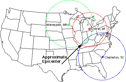
To determine the exact location of a quake, three seismographs are used in a method called triangulation. If you draw circles on a map around three different seismograph locations, where the radius of each is the distance from that station to the earthquake, the intersection of those three circles is the epicenter of the earthquake! (Show students Figure 1 to illustrate this point.)
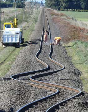
From the perspective of civil engineers, who design all sorts of structures, everything from skyscrapers, homes and schools to roads, tunnels, train tracks and bridges, it is important to know how both P waves and S waves travel. Because they are different types of waves, P waves and S waves impact and move the surface of the Earth and the ground below differently. Also, the impact of both these waves is more dramatic the closer to the epicenter of the earthquake. For our safety, civil engineers must understand both types of seismic waves, in order to design and build structures able to withstand the forces of earthquakes.
Procedure
Before the Activity
- Make copies of the Earthquake FAQs Worksheet, one per group. The worksheet serves as a student guide for the activity.
- Make arrangements so that each student group has a computer with Internet access.
With the Students
- Divide the class into small groups of two or three students each, and have them assemble at their computers with journals/paper and writing instruments.
- Hand out the worksheets to the groups and direct them to read through the instructions. Explain that they are to be inquisitive and explore all aspects of the Earthquakes Living Lab as they complete the worksheet. Encourage them to include their own maps and sketches as they document their research questions and answers.
- Before looking at the Earthquakes Living Lab, have groups complete the Engage section of the worksheet. See details in the Assessment section.
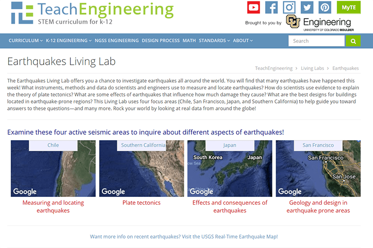
- Get the teams started by guiding them to the Earthquakes Living Lab via the living lab website at http://www.teachengineering.org/livinglabs/index.php. Have them scroll down to the Earthquakes Living Lab section (see Figure 2). Tell students that this activity is designed around the Earthquakes Living Lab, a resource and online interface that uses real-time, real-world seismic data gathered from around the world.

Figure 2. The entry web page for the Earthquakes Living Lab. - Have students click on the Earthquakes Living Lab hyperlink in the top left in the earthquakes section. On the main page of the Earthquakes Living Lab website (see Figure 3), notice the focus on four active seismic areas and historic earthquakes in those areas: Chile, Southern California, Japan and San Francisco. For this activity, you will select the Chile earthquake. In 2010, an earthquake occurred off the coast of central Chile, magnitude 8.8 on the Richter scale, which resulted in a tsunami, major property damage, and hundreds of deaths. The resources provided in the "Chile" section of the living lab focus primarily on the instruments, data and methods used to measure and locate earthquakes.

Figure 3. The main page of the Earthquakes Living Lab website. - Give students a few minutes to be inquisitive and to explore all aspects of the living lab.
- Then direct students to complete the first part of the activity, following the Explore, Explain and Elaborate worksheet instructions, which are also summarized below. Even though students work in groups, direct them to write their responses in their own journals, including questions, answers, notes and sketches.
- Of the four Earthquakes Living Lab seismic areas, click on the "Chile" box.
- Follow the link on the right side of the page titled, "What is the difference between a P wave and an S wave?"
- Examine the diagrams and read the information on the screen about P waves and S waves.
- Record your notes from this source (and other sources if needed) about P and S waves.
- Summarize your answer to the original question: What is the difference between P and S waves?
- To help illustrate your answer, include a sketch with labels and notes.
- Show your journal entries to the teacher to verify that you have enough detail and information, and then proceed with the next step.
- Next, begin the More Exploration section of the worksheet, by having students return to the Chile page at https://www.teachengineering.org/livinglabs/chile.
- Draw students' attention to the right side of the screen, which provides five additional FAQ categories. Ask students to explore a few categories and follow the links to see what information is provided. Direct them to survey the wide range of options available and not spend a lot of time on any one topic. Below find some descriptions (for the teacher) of the pages students will encounter; share this information with students, as necessary:
- For the "What is the difference between a P wave and an S wave?" category, students are presented with the USGS Measuring Earthquakes text and diagram, which provides information on seismic waves, how they feel, how they are measured, and their varied effects.
- For the "Where did earthquakes occur this week? How many? How big were they?" category, students arrive at an interactive USGS map of real-time, real-world seismic data. Dot placement indicates the locations of recent earthquakes. Dot size indicates magnitude. Dot color indicates how long since they occurred (during the past hour, day or week). As you use a mouse or touch pad to rescale the map, the left-side list updates to provide information on the earthquakes that occurred in the visible map area. Or, click on the gear icon at the top right to change the settings to view more earthquakes by specifying time periods. A count of the total number of earthquakes shown/listed is provided in the top left corner.
- For the "How is an earthquake epicenter located, and how is its magnitude determined?" category, in addition to the text and example seismogram, direct students to use the virtual earthquake simulation at this Geology Labs Online page. To do this, they choose a location and then get seismogram results like those that are used to "triangulate" to determine the location of earthquake epicenters (refer to Figure 1).
- For the "What else should I know about measuring earthquakes?" category, students arrive at the USGS FAQs page, which provides them with many common and uncommon questions/answers. Tip: Suggest students enter the search term "earthquakes" or look at the choices provided in the earthquake option on the left side of the page.
- The "What are the details of the geology and fault system at Talca, Chile?" category gets students to the Marine Science Plate Tectonics text with many explanatory diagrams.
- Have each group find at least three additional questions that they are interested in and ask them to follow the living lab links to research those questions.
- To complete the Explain/Elaborate section, have students record the following information in their journals for each of their four (or more) questions:
- The original question.
- Notes, facts, observations related to the question.
- A conclusion or summary answer to the question.
- To improve their research notes, at least one sketch, drawing or graphic organizer.
- When each group has finished its research and journal entries for the original question and at least three additional questions, have them submit their journals/writing for teacher review and grading.
- As a class, go through the worksheet and discuss the findings. Key discussion questions:
- What are seismic waves?
- How are seismic waves generated during an earthquake event?
- What are the differences between P waves and S waves?
- What are major features of the Earth's surface that lead to earthquake development?
- Why might engineers need to learn about the Earth's structure and earthquakes?
- What else did you learn about earthquakes that you found particularly interesting?
- Conclude by assigning groups to prepare posters or slide presentations on one of their researched questions, providing summary answers with visual aids, as described in the Assessment section.
Vocabulary/Definitions
earthquake: A natural destructive event that occurs when two tectonic plates suddenly slip past one another, creating seismic waves.
epicenter: The point of the Earth's surface directly above an earthquake's focus or origin.
lithosphere: The outermost rigid layer of the Earth, consisting of the crust and upper mantle. The lithosphere is broken into tectonic plates and is on average about 100 km thick.
P wave: A longitudinal (side-to-side) seismic wave that travels through the interior of the Earth and is the first wave to be felt in an earthquake. The P wave causes the ground to shake back and forth. P wave is short for primary wave or pressure wave.
S wave: A transverse (up-and-down) seismic wave. The S wave also travels through the interior of the Earth and is the second wave to be felt. S wave is short for secondary wave or shear wave.
seismic wave: A "wave" of energy created by an earthquake that travels through the Earth's layers.
seismograph: An instrument that measures motions of the ground, including those of seismic waves generated by earthquakes. Also called seismometer. The instrument detects and documents the intensity, direction and duration of ground vibrations, which are used to determine the strength or magnitude of earthquakes or other seismic events.
tectonic plates: Large sections of the Earth's crust (lithosphere layer) that move, float and sometimes fracture, and whose interaction causes much of the planet's seismic activity.
triangulate: A technique that uses the distances and angles between known points to find a location. As pertains to this activity, the use of three circular areas to find an earthquake's point of origin.
Assessment
Pre-Activity Assessment
Engage: Ask students to take a moment to think about what they already know about earthquakes. Have them record in their journals at least three facts they know and any questions they have about earthquakes. In addition, ask student groups to brainstorm reasons why engineers might need to know about earthquakes, and individually record their ideas. Have students share their responses with the class. (Possible answers: Engineers who design structures such as buildings, roads and bridges need to know the probability of earthquakes occurring at certain locations, how strong those earthquakes might be, how the soil and sub-soil in their areas respond to the ground movement of seismic waves, how certain construction materials respond to seismic movement, how certain construction designs and techniques hold up to seismic forces, etc., so that they can design structures that are strong and flexible enough to survive those forces and effects.)
Activity Embedded Assessment
Results and Discussion: Examine students' written journal entries in response to the Earthquake FAQs Worksheet guidance and living lab explorations, looking for breadth of exploration as well as accuracy. Also discuss the research results as a class. Ask students to share any learned information that they found particularly interesting.
Post-Activity Assessment
Sharing Information: Have each group prepare a poster or PowerPoint presentation to report to the class what students learned from their quest to answer one question generated from the worksheet-guided research. Require the posters/presentations to state the questions, as well as answers supported by research and visual aids such as sketches, drawings and/or graphic organizers. In addition, require groups to include engineering connections—at least one reason why engineers might need to know the answer to the question and how engineers might apply that knowledge. (Example reason: Engineers want to know as much as they can about earthquakes and their effects and consequences so they can use that information to design structures that remain intact and safe should they encounter the seismic forces of earthquakes. Also see the "possible answers" provided in the pre-activity assessment section.)
Activity Extensions
Have student groups explore the other three regions (Southern California, Japan and San Francisco) and concepts presented in the Earthquakes Living Lab.
Activity Scaling
Several options to increase the difficulty for upper grades:
- Have students work individually.
- Have students do more complex statistical evaluations such as finding the average amount of earthquakes per day/month/year worldwide, or calculating the area with the highest amount of seismic activity annually.
- Have students tabulate and then plot the amount of seismic activity versus time for the area they determine to have the most annual earthquakes.
Subscribe
Get the inside scoop on all things Teach Engineering such as new site features, curriculum updates, video releases, and more by signing up for our newsletter!More Curriculum Like This

They make a model of a seismograph—a measuring device that records an earthquake on a seismogram. Students also investigate which structural designs are most likely to survive an earthquake.

Students learn how engineers characterize earthquakes through seismic data. Then, acting as engineers, they use real-world seismograph data and a tutorial/simulation accessed through the Earthquakes Living Lab to locate earthquake epicenters via triangulation and determine earthquake magnitudes.

Students learn about the types of seismic waves produced by earthquakes and how they move through the Earth. Students learn how engineers build shake tables that simulate the ground motions of the Earth caused by seismic waves in order to test the seismic performance of buildings.

Students learn about seismology by using a sample seismograph constructed out of common classroom materials. The students work in groups to represent an engineering firm that must analyze the seismograph for how it works and how to read the seismogram it creates.
References
Wald, Lisa. The Science of Earthquakes. Last modified July 18, 2012. Earthquakes Hazards Program, U.S. Geological Survey, U.S. Department of the Interior. Accessed July 2013. (Good questions/answers about earthquakes) http://earthquake.usgs.gov/learn/kids/eqscience.php
Other Related Information
This activity is designed around the Earthquakes Living Lab, a resource and online interface that uses real-time U.S. Geological Survey seismic data from around the world. The living lab presents earthquake information through a focus on four active seismic areas and historic earthquakes in those areas. The real-world earthquake data is viewable via a graphical interface using a scaling map.
Copyright
© 2013 by Regents of the University of Colorado; original © 2013 Colorado School of MinesContributors
Mike Mooney; Minal Parekh; Scott Schankweiler; Jessica Noffsinger; Karen Johnson; Jonathan KnudtsenSupporting Program
Civil and Environmental Engineering Department, Colorado School of MinesAcknowledgements
This curriculum was created with the support of National Science Foundation grant no. DUE 0532684. However, these contents do not necessarily represent the policies of the National Science Foundation, and you should not assume endorsement by the federal government.
Last modified: November 7, 2018


User Comments & Tips