Quick Look
Grade Level: 7 (6-8)
Time Required: 2 hours 15 minutes
(90 minutes for rock testing; 45 minutes to answer worksheet questions 2-7)
Expendable Cost/Group: US $0.00 Also requires some non-expendable (reusable) items; see the Materials List for details.
Group Size: 3
Activity Dependency: None
Subject Areas: Earth and Space, Physical Science, Problem Solving
Summary
Continuing the Asteroid Impact challenge, student teams test rocks to identify their physical properties such as luster, hardness, color, etc., and classify them as igneous, metamorphic or sedimentary. They complete a data table to record all of the rock properties, and then answer worksheet questions to deepen their understanding of rock properties and relate them to the cavern design problem.
Engineering Connection
Civil and geological engineers, for example, design tunnels through rock, build roads on the sides of mountains, and construct skyscrapers rooted in soil and rock. It is imperative for these engineers to thoroughly understand the natural characteristics and properties of all types of rocks to ensure health and safety standards are met.
Learning Objectives
After this activity, students should be able to:
- Gather data by performing scientific observation and testing of rocks.
- Use the data and a flowchart to determine rock types and rock classification.
- Identify rock types by distinguishing features.
- Relate rocks-in-hand to geological formations on maps.
- Relate the relevance of each tested/observed rock characteristic to designing/building caverns.
Educational Standards
Each TeachEngineering lesson or activity is correlated to one or more K-12 science,
technology, engineering or math (STEM) educational standards.
All 100,000+ K-12 STEM standards covered in TeachEngineering are collected, maintained and packaged by the Achievement Standards Network (ASN),
a project of D2L (www.achievementstandards.org).
In the ASN, standards are hierarchically structured: first by source; e.g., by state; within source by type; e.g., science or mathematics;
within type by subtype, then by grade, etc.
Each TeachEngineering lesson or activity is correlated to one or more K-12 science, technology, engineering or math (STEM) educational standards.
All 100,000+ K-12 STEM standards covered in TeachEngineering are collected, maintained and packaged by the Achievement Standards Network (ASN), a project of D2L (www.achievementstandards.org).
In the ASN, standards are hierarchically structured: first by source; e.g., by state; within source by type; e.g., science or mathematics; within type by subtype, then by grade, etc.
NGSS: Next Generation Science Standards - Science
-
Structures can be designed to serve particular functions by taking into account properties of different materials, and how materials can be shaped and used.
(Grades 6 - 8)
More Details
Do you agree with this alignment?
-
Analyze and interpret data to determine similarities and differences in findings.
(Grades 6 - 8)
More Details
Do you agree with this alignment?
-
Collect data to produce data to serve as the basis for evidence to answer scientific questions or test design solutions under a range of conditions.
(Grades 6 - 8)
More Details
Do you agree with this alignment?
International Technology and Engineering Educators Association - Technology
-
Students will develop an understanding of the relationships among technologies and the connections between technology and other fields of study.
(Grades
K -
12)
More Details
Do you agree with this alignment?
Materials List
Each group needs:
- rock testing kit (see component list, below); such as the Home Science Tools 15-specimen rock test kit (containing the necessary 8 rock samples) for $15.50 at http://www.hometrainingtools.com/rock-study-kit?fee=2&fep=2249&gclid=CPL-qq3_6MoCFZOCaQod2F0Bcg
- (optional) mineral testing kit, such as the Home Science Tools mineral test kit for $7 at http://www.hometrainingtools.com/mineral-test-kit
- textbook or reference to classify the rocks (igneous, sedimentary, metamorphic)
- paper towel
- 3 handouts: Rocks, Rocks, Rocks Worksheet; Rock Test Data Table; Rock Identification Flow Chart
Each rock testing kit needs:
- 8 rock samples of the rocks listed on the Alabraska Geology Map: basalt, sandstone, limestone, granite, gneiss, slate, pumice, obsidian (not sand/gravel)
- steel nail
- copper penny
- streak plate, stuch as an unglazed porcelain tile
- magnet
- hydrochloric acid; alternatively, use vinegar
- magnifying glass
- small piece of glass
- small steel plate
- piece of quartz
- cup of water
Worksheets and Attachments
Visit [www.teachengineering.org/activities/view/csm_asteroid_lesson5_activity1_tg] to print or download.Pre-Req Knowledge
A general familiarity with rocks and minerals.
Introduction/Motivation
Some rocks are not suitable for caverns. So, to determine the best place to locate your cavern, you need to get an understanding of the types of rocks and their properties throughout the varied terrain of the state of Alabraska.
Different rock types vary by region, so today you will be performing some rock tests so you can learn their properties, identify them and classify them as sedimentary, igneous or metamorphic.
- Igneous rocks are formed directly from the cooling of magma and make up the majority of the Earth's crust.
- Sedimentary rocks are often called "secondary" rocks, because they form from small pieces of other types of rocks, or from minerals that were previously dissolved in water (like the silt in lakes, rivers and seas). These are commonly found in dry areas.
- Metamorphic rocks are those that have been changed over time due to different chemical surroundings, heat and pressure.
Procedure
Background Information
As necessary, supplement students' understanding of basic rock/mineral testing, rock identification, and rock classification (sedimentary, igneous, metamorphic).
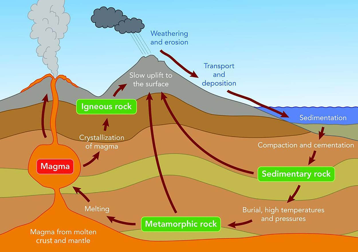
The basic explanation of the rock cycle follows: Rocks are pushed deep into the Earth's surface, usually by tectonic motion, where they melt into magma. At a volcano, or anywhere magma is exposed to become lava (such as at divergent tectonic plates), the magma/lava cools to become igneous rock. Several processes may occur after this, for example kaolinization, which generates granite and other common igneous rocks. Metamorphic rocks are created in a different process than igneous rocks, a process that is characterized by high temperatures and pressures, changing the physical and chemical properties. These high temperatures and pressures are found in mountain-building events or through close proximity to igneous intrusions, where high temperatures exist from the cooling magma. Rocks exposed to the atmosphere suffer weathering and erosion, breaking into smaller fragments. The fragments accumulate, compress, and fuse to generate sedimentary rocks, such as limestone.
Before the Activity
Gather materials and make copies of the handouts.
With the Students
- Start with a class discussion about rock properties and rock classification:
- Describe the various rock characteristics: luster (how light is reflected), hardness (ability to resist being scratched), granular (texture of the specimen), porous (how many small holes/pores), color.
- Describe the various rock names (refer to the Alabraska Geology Map) and the three rock classifications: sedimentary, igneous and metamorphic.
- Illustrate the rock cycle and emphasize the different formation routes of the three main rock types. The following diagram is useful.

- Distribute rock testing kits and handouts to each team. Three possible ways to distribute the rocks and conduct testing:
- Quickest and most suitable for a mature class: Give each team all the rocks to test and discuss the results as a class after all testing and identification has been performed and recorded.
- Give each group a different rock and after 5 minutes of testing, stop the class. Discuss the results using the flow chart and have the class chart each group's result.
- Pass out one rock at a time to each group and allot 5 minutes to test, discuss and decide on its rock name. After 5 minutes, ask questions from the flow chart to guide students to the correct rock name and chart the results.

- Provide students with some information to classify the rocks as sedimentary, igneous or metamorphic, such as a textbook, website material or verbal explanation.
- Have students refer back to the Alabraska map and have them identify the best area for their cavern to be built while referring to their worksheet answers.
- Lead a concluding class discussion to review students' answers to the the worksheet questions, as described in the Assessment section.
Assessment
Worksheet & Data Table: Review students' data and answers on the Rock Test Data Table and Rocks, Rocks, Rocks Worksheet to gauge their mastery of the concepts. Refer to the Asteroid Impact Student Workbook Example Answers provided in the unit document for example data table and worksheet answers.
Concluding Class Discussion: After testing and recording is done and students have completed the worksheet questions, which are intended to give meaning and context to the rock properties, lead a class discussion to review those answers. Discussing the answers is beneficial to the overall project and to students' retention of rock property descriptions. Also ask students:
- Why is it important to know rock properties before you build in it?
- How might these characteristics affect your cavern? (Possible answers: A soft rock might cave in, an extremely hard rock might be too difficult to drill through, a porous rock might let water flood the caverns, etc.)
- What is one way in which igneous rocks form?
- What is one way in which sedimentary rocks form?
- What does metamorphic mean?
Activity Extensions
Have students find geology maps for their state and determine the most common rock types present in their state or region. Applying their findings in this activity, have them determine the best locations to build caverns in their state.
Activity Scaling
For younger students, have the teacher do the testing in the front of the classroom (more of a class demo), asking questions from the flow chart. Then talk students through charting the results.
Subscribe
Get the inside scoop on all things Teach Engineering such as new site features, curriculum updates, video releases, and more by signing up for our newsletter!More Curriculum Like This

Students are introduced to three types of material stress related to rocks: compressional, torsional and shear. They learn about rock types (sedimentary, igneous and metamorphic), and about the occurrence of stresses and weathering in nature, including physical, chemical and biological weathering.

The purpose of this lesson is to introduce students to the basic elements of our Earth's crust: rocks, soils and minerals. They learn how we categorize rocks, soils and minerals and how they are literally the foundation for our civilization.

Students learn the components of the rock cycle and how rocks can change over time under the influence of weathering, erosion, pressure and heat. They learn about geotechnical engineering and the role these engineers play in land development, the design and placement of new structures and natural di...

Students are introduced to the primary types of erosion—chemical, water, wind, glacier and temperature. Students investigate examples of each erosion type and discuss how erosion changes the surface of the Earth.
Copyright
© 2013 by Regents of the University of Colorado; original © 2005 Colorado School of MinesSupporting Program
Adventure Engineering, Colorado School of MinesAcknowledgements
Adventure Engineering was supported by National Science Foundation grant nos. DUE 9950660 and GK-12 0086457. However, these contents do not necessarily represent the policies of the National Science Foundation, and you should not assume endorsement by the federal government.
Last modified: June 27, 2025


User Comments & Tips