Quick Look
Grade Level: 6 (5-7)
Time Required: 45 minutes
Expendable Cost/Group: US $1.00 If available, this activity works well using Google Maps on computers with Internet access.
Group Size: 4
Activity Dependency: None
Subject Areas: Physical Science

Summary
The pervasiveness of aircraft in our world has decreased the amount of time it takes to transport people and cargo. Guided by a worksheet and either using paper maps or online Google Maps, student teams compute and compare the time it takes to travel between two sets of cities (two near each other, two far from each other) via several different modes of transportation including trucks, trains and airplanes. Then they do some critical thinking to come to some conclusions about why airplanes are not always the transport option of choice.Engineering Connection
Engineers balance many different factors when designing airplanes. Airplanes are great for transporting cargo because they are much faster than trucks and trains. Often though, engineers do not build transport aircraft to go as fast as is possible because the cost to produce and operate these vehicles is expensive. Therefore, engineers find a compromise between cost and speed by designing aircraft that moves cargo to a desired destination quickly, but also does not waste money and resources going excessively fast.
Learning Objectives
After this activity, students should be able to:
- Compare and contrast different modes of transportation.
- Explain how technology can affect individuals and communities.
- Use equations to determine the time required to travel different distances.
- Interpret and evaluate data on a chart in order to formulate conclusions.
Educational Standards
Each Teach Engineering lesson or activity is correlated to one or more K-12 science,
technology, engineering or math (STEM) educational standards.
All 100,000+ K-12 STEM standards covered in Teach Engineering are collected, maintained and packaged by the Achievement Standards Network (ASN),
a project of D2L (www.achievementstandards.org).
In the ASN, standards are hierarchically structured: first by source; e.g., by state; within source by type; e.g., science or mathematics;
within type by subtype, then by grade, etc.
Each Teach Engineering lesson or activity is correlated to one or more K-12 science, technology, engineering or math (STEM) educational standards.
All 100,000+ K-12 STEM standards covered in Teach Engineering are collected, maintained and packaged by the Achievement Standards Network (ASN), a project of D2L (www.achievementstandards.org).
In the ASN, standards are hierarchically structured: first by source; e.g., by state; within source by type; e.g., science or mathematics; within type by subtype, then by grade, etc.
NGSS: Next Generation Science Standards - Science
-
Analyze and interpret data to determine similarities and differences in findings.
(Grades 6 - 8)
More Details
Do you agree with this alignment?
-
Use mathematical representations to describe and/or support scientific conclusions and design solutions.
(Grades 6 - 8)
More Details
Do you agree with this alignment?
Common Core State Standards - Math
-
Fluently divide multi-digit numbers using the standard algorithm.
(Grade
6)
More Details
Do you agree with this alignment?
-
Solve unit rate problems including those involving unit pricing and constant speed.
(Grade
6)
More Details
Do you agree with this alignment?
International Technology and Engineering Educators Association - Technology
-
Transporting people and goods involves a combination of individuals and vehicles.
(Grades
6 -
8)
More Details
Do you agree with this alignment?
State Standards
Colorado - Math
-
Use ratio and rate reasoning to solve real-world and mathematical problems.
(Grade
6)
More Details
Do you agree with this alignment?
-
Fluently divide multi-digit numbers using standard algorithms.
(Grade
6)
More Details
Do you agree with this alignment?
Colorado - Science
-
Research and critically evaluate data and information about the advantages and disadvantages of using fossil fuels and alternative energy sources
(Grade
6)
More Details
Do you agree with this alignment?
Materials List
Each group needs:
- 1 city/state/county map, either paper maps or Google Maps with a computer and Internet access; such as city/state maps at https://www.google.com/maps/preview?source=newuser-ws and topographical maps at https://www.usgs.gov/the-national-map-data-delivery/topographic-maps
- 2-3 sheets of blank scrap paper and pencils
- ruler (if using paper maps)
- Let's Get It There Fast! Worksheet, one per student
- (optional) Transportation Overhead Transparency, one per class
- (optional) calculator; groups may share
Worksheets and Attachments
Visit [www.teachengineering.org/activities/view/cub_airplanes_lesson08_activity1] to print or download.Introduction/Motivation
Transportation time varies for trucks, trains and airplanes. Sometimes, an airplane is the fastest way to get products from place to place. Are airplanes always a good means of transportation? Would an airplane be the best way to get a plate of cookies from your house to a neighbor's house two blocks away? Probably not. Flying an airplane for a distance of two blocks would not be practical or economical. Engineers, therefore, design transportation to not only be fast, but economical as well. Which costs more to build and maintain: a plane or a truck? (Answer: A plane.) Engineers also consider how well transportation is suited to different areas, environments and terrains. Can you drive a truck across a lake? (Answer: Not without a bridge or tunnel—which ultimately adds cost to that mode of transportation.) Engineers are responsible for the design of the various vehicles used for transportation (trucks, cars, airplanes, boats, etc.), and also for the support they need, including airports, roads and bridges.
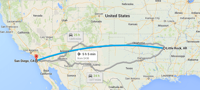
(Show students Figure 1.) This map shows the route between Little Rock, AR, and San Diego, CA. The distance between the two cities is 1,728 miles. It is estimated that it takes 29 hours and 9 minutes to travel that distance by car. Does this seem like a long time?

Who has been on a train? An airplane? A truck? In this activity, we will discuss how long it takes an airplane to fly from one destination to another and how that time compares to covering the same distances using other modes of transportation: trucks and trains. We will also explore why planes are sometimes used and why other modes of transportation are sometimes employed.
Procedure
Before the Activity
- Decide whether to use paper maps or Google Maps with computers and Internet access.
- Gather materials and make copies of the Let's Get It There Fast! Worksheet and maps for each group (if using paper maps)
- If students will be using the Internet, set up the computers so that Google Maps is on the screen (go to https://www.google.com/maps/preview?source=newuser-ws). To find the distance between two cities, click on the "Directions" button (click in the Search box located in the upper left corner and the "Directions" button appears underneath). From here, type in the beginning city and state and the destination (location to ship to) city and state. For example: Denver, CO, to Philadelphia, PA.
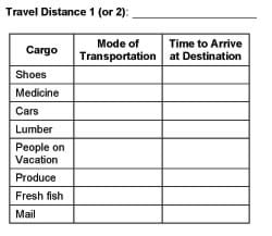
- Decide whether to use the Transportation Overhead Transparency or draw charts on the classroom board. Then either prepare to use the overhead transparency or create a chart on the classroom board with the headings shown in Figure 1.

With the Students
- Divide the class into groups of four to six students each.
- Give each group a worksheet and scrap paper.
- Direct students to follow the worksheet instructions. Students pick two sets of cities: one pair that is close together (such as Denver and Boulder, CO), and another that are far away from each other (such as Boston, MA, and Los Angeles, CA). (Note: Use two separate charts for both distances calculated.)
- After giving students time to complete the worksheet and assignment, have one person from each group rotate to another group and discuss his/her group's findings. Do this until each group has discussed its findings with all group representatives. During this process, have all students give input.
- Have students share and compile their findings into the classroom board chart (like Figure 1) or the overhead transparency version.
Assessment
Pre-Activity Assessment
Class Definition: Have the class brainstorm definitions for the following terms: transportation, aviation, cargo, shipping. Write the definitions on the classroom board.
Activity-Embedded Assessment
Worksheet: Have students use the Let's Get It There Fast! Worksheet to guide them through the activity, recording distances, mode of transportation and time to arrival. At activity end, review their data, calculations and answers to gauge their engagement and depth of comprehension.
Post-Activity Assessment
Roundtable/Rating: Have students form into teams of three to five students each. Ask the class a question with many possible answers. Students on a team make a list, each one writing an answer and passing the paper on to the next person. Have the teams share their responses with the class.
- Example question: What mode of transportation can be used to move a person over a distance of 100 miles?
- Mark each type as expensive ($$$) or not expensive ($).
- Mark each type as slow (S) or fast (F).
- Mark each type as having a big effect on the environment (↑) (a lot of roads, pollution, etc.) or little effect on the environment (↓).
- Ask each group to pick its top three modes of transportation for a distance of 100 miles and explain why they picked that mode.
Discussion: Solicit, integrate, and summarize student responses.
- What have you learned?
- Why is it that airplanes are not always used to transport items?
- Is it efficient to fly from Boulder, CO, to Denver, CO?
- Why is it that items such as cars are not transported in airplanes?
- Why did you choose certain modes of transportation for various items and how much time did it take for each vehicle to reach its destination?
Troubleshooting Tips
It helps to model one or two examples of how to find the distance between two cities using a ruler (or the Internet) and how to calculate the time it takes to travel this distance.
Activity Extensions
As a class, have students think of another form of transportation (such as walking or riding a llama) and then try to solve the problems including the new form of transportation.
Have students come up with other goods that they want to transport. Then have them figure out the best method of transporting them in the least amount of time. Use the Transportation Overhead Transparency and fill in the blank rows with suggested items.
For extra math practice, have students calculate the speed in metric units. For example, 1 mph is approximately 1.6 kilometer per hour.
Activity Scaling
For younger students, model the math calculations on the classroom board before they try to do the math on their own.
Subscribe
Get the inside scoop on all things Teach Engineering such as new site features, curriculum updates, video releases, and more by signing up for our newsletter!Copyright
© 2004 by Regents of the University of ColoradoContributors
Tom Rutkowski; Alex Conner; Geoffrey Hill; Malinda Schaefer Zarske; Janet YowellSupporting Program
Integrated Teaching and Learning Program, College of Engineering, University of Colorado BoulderAcknowledgements
The contents of this digital library curriculum were developed under grants from the Fund for the Improvement of Postsecondary Education (FIPSE), U.S. Department of Education and National Science Foundation (GK-12 grant no. 0338326). However, these contents do not necessarily represent the policies of the Department of Education or National Science Foundation, and you should not assume endorsement by the federal government.
Last modified: February 1, 2022


User Comments & Tips