Quick Look
Grade Level: 7 (6-8)
Time Required: 15 minutes
Lesson Dependency: None
Subject Areas: Earth and Space
NGSS Performance Expectations:

| MS-ESS2-2 |
Summary
Students investigate how mountains are formed. Concepts include the composition and structure of the Earth's tectonic plates and tectonic plate boundaries, with an emphasis on plate convergence as it relates to mountain formation. Students learn that geotechnical engineers design technologies to measure movement of tectonic plates and mountain formation, as well as design to alter the mountain environment to create safe and dependable roadways and tunnels.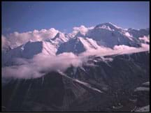
Engineering Connection
Engineers create tunnels through mountains for transportation purposes. Before constructing a mountain tunnel, geotechnical engineers bore test holes into the mountain rock to sample and analyze the material that will be bored or drilled into during tunnel construction. To succeed with these big projects, engineers must have a solid understanding of the drilling process, and the composition and features of the mountain of interest—both of which are determined during the mountain's ancient formation.
Learning Objectives
After this lesson, students should be able to:
- Explain the connection between tectonic plates and mountain formation.
- Describe several types of technologies designed by engineers that are related to mountain formation, including tools and processes for measuring formation, predicting natural hazards, and determining the location of natural resources.
Educational Standards
Each TeachEngineering lesson or activity is correlated to one or more K-12 science,
technology, engineering or math (STEM) educational standards.
All 100,000+ K-12 STEM standards covered in TeachEngineering are collected, maintained and packaged by the Achievement Standards Network (ASN),
a project of D2L (www.achievementstandards.org).
In the ASN, standards are hierarchically structured: first by source; e.g., by state; within source by type; e.g., science or mathematics;
within type by subtype, then by grade, etc.
Each TeachEngineering lesson or activity is correlated to one or more K-12 science, technology, engineering or math (STEM) educational standards.
All 100,000+ K-12 STEM standards covered in TeachEngineering are collected, maintained and packaged by the Achievement Standards Network (ASN), a project of D2L (www.achievementstandards.org).
In the ASN, standards are hierarchically structured: first by source; e.g., by state; within source by type; e.g., science or mathematics; within type by subtype, then by grade, etc.
NGSS: Next Generation Science Standards - Science
-
DCI.ESS2.A.6-8.5.
The planet's systems interact over scales that range from microscopic to global in size, and they operate over fractions of a second to billions of years. These interactions have shaped Earth's history and will determine its future.
(Grades 6 - 8)
More Details
Do you agree with this alignment?
-
DCI.ESS2.B.6-8.3.
Maps of ancient land and water patterns, based on investigations of rocks and fossils, make clear how Earth's plates have moved great distances, collided, and spread apart.
(Grades 6 - 8)
More Details
Do you agree with this alignment?
| NGSS Performance Expectation | ||
|---|---|---|
|
MS-ESS2-2. Construct an explanation based on evidence for how geoscience processes have changed Earth's surface at varying time and spatial scales. (Grades 6 - 8) Do you agree with this alignment? |
||
| Click to view other curriculum aligned to this Performance Expectation | ||
| This lesson focuses on the following Three Dimensional Learning aspects of NGSS: | ||
| Science & Engineering Practices | Disciplinary Core Ideas | Crosscutting Concepts |
| Construct a scientific explanation based on valid and reliable evidence obtained from sources (including the students' own experiments) and the assumption that theories and laws that describe the natural world operate today as they did in the past and will continue to do so in the future. Alignment agreement: | The planet's systems interact over scales that range from microscopic to global in size, and they operate over fractions of a second to billions of years. These interactions have shaped Earth's history and will determine its future. Alignment agreement: Water's movements—both on the land and underground—cause weathering and erosion, which change the land's surface features and create underground formations.Alignment agreement: | Time, space, and energy phenomena can be observed at various scales using models to study systems that are too large or too small. Alignment agreement: |
State Standards
Colorado - Science
-
Geologic time, history, and changing life forms are indicated by fossils and successive sedimentation, folding, faulting, and uplifting of layers of sedimentary rock
(Grade
7)
More Details
Do you agree with this alignment?
Worksheets and Attachments
Visit [www.teachengineering.org/lessons/view/cub_rock_lesson04] to print or download.Pre-Req Knowledge
Students should have some familiarity with the existence of tectonic plates, that they move and the various tectonic plate boundaries that exist.
Introduction/Motivation
Did you know that we live on gigantic moving rocks? We call these rocks tectonic plates. They are what make mountain formation possible. What happens when the Earth's 14 major tectonic plates and many minor ones are all moving around? They are bound to start bumping into each other! Natural phenomena such as earthquakes, mountain formation, and volcanoes occur at plate boundaries. Mountains are usually formed at what are called convergent plate boundaries, meaning a boundary at which two plates are moving towards one another. This type of boundary eventually results in a collision. Tectonic plate collisions take a long time, as plates only shift a few centimeters each year, but they can still be powerful enough to form the Earth's largest mountain ranges!
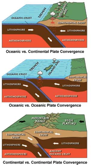
So what happens when the convergent plates finally collide? Well, a few different possibilities can occur. Sometimes, the two tectonic plates press up against each other, causing the land to lift into mountainous forms as the plates continue to collide. Another possibility is that one plate pushes on top of the other, sending it downward into the Earth! We call this a subduction zone. The mountains formed from this powerful compressive process are called complex mountains.
Given these options, how do we know which possibility will occur? It depends on the composition of the tectonic plates involved in the collision. Tectonic plates are either made up of oceanic crust or continental crust. Oceanic crust is mainly made of basaltic rocks, and continental crust is mainly made of felsic rocks. Basaltic rocks are denser than felsic rocks; therefore, oceanic crust is denser than continental crust. So, if an oceanic tectonic plate collides with a continental plate, the denser oceanic plate is likely to sink beneath the continental plate, creating a subduction zone. If, however, two continental plates (therefore of similar density) smack into one another, they, instead, lift up against one another.
Let's look at some diagrams. (By paper handout or overhead projection, show students what happens in the various plate convergence scenarios, as shown in the attached Tectonic Plates Convergence Handout-Overhead.)
Now that we have talked about complex mountains, let's briefly touch on two other types of mountains. Fault-block mountains are formed by an entirely different process. These mountains are produced when tectonic plates are stretched to the point that they crack and slide. These cracks, or vertical faults, are fractures in the continental crust. Crust is then squeezed upward between the two parallel lines, resulting in mountains! And finally, the term erosional mountain describes mountains that are formed due to the erosion of uplifted rocks in the Earth's geography. This process occurs when rivers, over time, carve away at a region of uplifted geography.
But bumps and hills are all over this planet — so what constitutes a mountain? Mountains are landforms that extend above their surrounding areas in a limited area. That is a very general definition! No required elevation exists for a mountain to be called a mountain, so what makes a mountain different from a hill? Mountains are generally considered to be higher and steeper than a hill, but the definitions ultimately depend on local custom. A hill to some is a mountain to others, and visa versa!
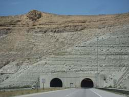
Geotechnical engineers study mountains and the movement of tectonic plates for a variety of purposes. They observe plate movements to design technologies to measure the movement of tectonic plates and mountain formation in order to predict earthquakes and how to best protect people from them. Using these technologies, they develop processes and rules for developing communities and roadways around tectonic plate movement (adding extra support requirements to structures on an earthquake fault line). They also use the information to develop technologies that predict locations at which geothermal, oil, natural gas and coal resources may be located. Sometimes geotechnical engineers work with other engineers to turn the geological formations themselves into resources for humans, such as mountain tunnels, dams and roads. After completing the lesson refer to the hands-on associated activity Tunnel Through! to have student teams model the challenges of engineering a tunnel through a mountain for transportation purposes .
Lesson Background and Concepts for Teachers
The Earth's internal structure makes the land and oceans prone to mountain formation. The lithosphere, Earth's rigid top layer of rock, floats on the asthenosphere, Earth's hot, malleable layer beneath the lithosphere. The rigid lithosphere layer is about 100 km (60 miles) thick and makes up the Earth's enormous moving rocks called tectonic plates; 14 major tectonic plates and 38 minor plates are identified. (The Earth's major tectonic plates are the African, Antarctic, Arabian, Australian, Caribbean, Cocos, Eurasian, Indian, Juan de Fuca, Nazca, North American, Pacific, Philippine, and South American Plates.) Tectonic plates are further classified into two major groups based upon their composition: oceanic crust and continental crust. Typically, a single tectonic plate can contain both oceanic and continental crust. Oceanic crust is mainly comprised of basaltic rocks, whereas continental crust is largely made up of felsic rocks, which are lower in density.
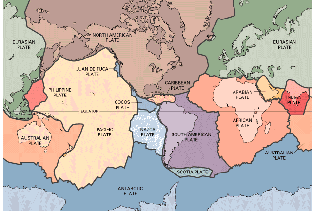
Currents acting on the asthenosphere push the Earth's tectonic plates in lateral movements. Because the lithosphere essentially floats on the asthenosphere, movement in the asthenosphere gets transferred to the lithosphere, causing the Earth's tectonic plates to move in different directions. The currents causing this movement in the asthenosphere are not entirely understood, but the Earth's internal heat engine is the hypothesized cause.
Three types of tectonic pl ate boundaries exist: convergent, divergent and transform. Mountains are formed by plate convergence. Plate convergence describes tectonic plate movement that results in the collision of two plates. These slow-moving collisions shift the plates only a few centimeters a year, but are powerful enough to form large mountain ranges over time.
Plate convergence resulting in mountain formation occurs in several ways. First, two tectonic plates can be pressed up against each other until the land lifts and folds over itself. If the two plates involved in the process contain continental crust, it is called a continental collision. Second, one plate can push on top of another, causing the latter to slide downward into the Earth. This is called a subduction zone (when one plate moves underneath the other). At that place, it begins to melt, leading melted rock to escape through cracks and weak spots, and burst out as fiery volcanoes. Third, tectonic plates can stretch until they crack and slide, resulting in fault-block mountains. And finally, underwater mountains are formed when tectonic plates spread away from one another, allowing melted rock to push up through the gap. This process is more common, as mountain formation occurs more often in oceans than on land.
Because mountain peaks experience higher elevations than their surrounding areas, they also experience cold temperatures in higher layers of the atmosphere. Mountains therefore often experience glaciation, when glaciers carve and shape mountain peaks by carrying rocks with them as their ice melts or shifts downward. This process carves sharp horns, rounded bowls, and u-shaped valleys into mountains, creating the images that come to mind when we think about mountains. Mountains can also change shape due to other natural elements such as rain, wind or ice wearing away the rock. Eventually, previously high jagged peaks naturally become low rounded hills and ultimately wear down into soil, sand or sediments.
Associated Activities
- Tunnel Through! - Student teams model the challenges of engineering a tunnel through a mountain for transportation purposes while designing and constructing model tunnels with limited resources that meet given design constraints and requirements.
Lesson Closure
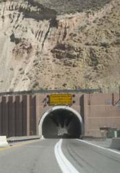
Now that we've talked about mountain formation, describe for me the outer layers of the Earth (Listen and clarify student descriptions). Explain how tectonic plate movement is linked to the formation of mountain ranges. (Listen and clarify student descriptions.) How is this information important to the daily lives of many people? (Listen and add to student answers.) In today's fast-paced world, people who want to get from one side of a mountain to the other prefer the quickest route—driving through! Who are the people responsible for designing tunnels? (Engineers make driving directly through mountains a possibility by designing and constructing mountain tunnels, saving countless travelers, haulers, commuters, emergency vehicles, truckers and vacationers time on the road each day.
Vocabulary/Definitions
asthenosphere: Earth's malleable layer located beneath the lithosphere.
basaltic: Gray to black volcanic rocks.
complex mountains: Mountains formed due to tectonic plates being subjected to large compressive forces.
continental collision: Two plates in motion toward one another cause mountain formation and the collision of two continents.
continental crust: The part of the lithosphere that forms the continents. This material is less dense than oceanic crust, but is considerably thicker.
convergent plates: Two tectonic plates in motion toward one another.
divergent plates: Two tectonic plates in motion away from one another.
fault-block mountains: Mountains formed when continental tectonic plates stretch to the point that they crack and slide.
felsic: Refers to silicate minerals, magmas, and rocks that contain lighter elements such as silica, oxygen, aluminum, sodium and potassium.
lithosphere: Earth's rigid outer layer, consisting of the crust and outermost mantle.
oceanic crust: The part of the lithosphere found in the ocean. This crust is generally composed of mafic basaltic rocks and is denser than continental crust.
subduction zone: When one tectonic plate moves beneath another at a plate boundary. This takes place at convergent plate boundaries if one or both of the tectonic plates at the boundary is made of oceanic crust.
tectonic plates: Large sections that make up the Earth's lithosphere.
transform plates: Two plates that slide and grind against each other in a horizontal direction along a transform fault.
Assessment
Pre-Lesson Assessment
Class Discussion: Ask students what they know about mountain formation to see if they can explain it to you before launching into the lesson.
Post-Introduction Assessment
Class Vote: Give the students several True/False statements about the lesson material and have them vote on whether they think the answers are true or false.
- True or False: The asthenosphere is located below the lithosphere. (Answer: True)
- True or False: The Earth has total tectonic plates. (Answer: False. 14 major tectonic plates, plus numerous [~38] minor ones.)
- True or False: Oceanic crust is denser than continental crust. (Answer: True)
- True or False: Mountains can be formed at convergent plate boundaries. (Answer: True)
- True or False: The lithosphere is Earth's rigid surface layer. (Answer: False. The asthenosphere is Earth's rigid surface layer. The lithosphere is Earth's hot malleable layer located beneath the asthenosphere.)
Lesson Summary Assessment
Student-Generated Questions: Have each student come up with one question to ask the rest of the class on the lesson topic. They should each know the answer to their question! Be prepared to help some students form questions. Have students take turns asking their questions to the class or collect the questions and answers to ask them back to the class in a random order.
Homework
Peak to Peak: Have each student research a mountain range. How was it formed and when? What makes the mountain range unique? Have them present their findings to the class or turn in a written paragraph.
Lesson Extension Activities
If you live near a mountain range, have a geologist take your class on a hike and talk about the formation of your local range and rock composition.
Have students recreate a mountain range using clay and present it to the class. Require their models to be topographically accurate and to scale.
Have students research the Earth's tectonic plates. Are any current movements expected to result in mountain formation?
Subscribe
Get the inside scoop on all things Teach Engineering such as new site features, curriculum updates, video releases, and more by signing up for our newsletter!More Curriculum Like This

Students learn about major landforms (such as mountains, rivers, plains, valleys, canyons and plateaus) and how they occur on the Earth's surface. They learn about the civil and geotechnical engineering applications of geology and landforms, including the design of transportation systems, mining, ma...

Students are introduced to three types of material stress related to rocks: compressional, torsional and shear. They learn about rock types (sedimentary, igneous and metamorphic), and about the occurrence of stresses and weathering in nature, including physical, chemical and biological weathering.

Students learn about the structure of the earth and how an earthquake happens. In one activity, students make a model of the earth including all of its layers. In a teacher-led demonstration, students learn about continental drift. In another activity, students create models demonstrating the di...

Students learn about the causes, composition and types of volcanoes. They begin with an overview of the Earth's interior and how volcanoes form. Once students know how volcanoes function, they learn how engineers predict eruptions.
References
Cameron, Ward. 2005. Understanding the Formation of the Rocky Mountains. www.MountainNature.com, Field Guide for the Next Millennium. Accessed September 3, 2008.
Convergent Plate Boundaries, USGS Geology in the Parks. Last updated January 13, 2004.US Geological Survey, US Department of the Interior. Accessed September 3, 2008. http://wrgis.wr.usgs.gov/
WVGES Geology: Mountains. Last revised July 9, 2004. West Virginia Geological and Economic Survey. Accessed September 3, 2008. http://www.wvgs.wvnet.edu/
Copyright
© 2008 by Regents of the University of ColoradoContributors
Marissa Hagan Forbes; Malinda Schaefer Zarske; Denise W. CarlsonSupporting Program
Integrated Teaching and Learning Program, College of Engineering, University of Colorado BoulderAcknowledgements
The contents of this digital library curriculum were developed under grants from the Fund for the Improvement of Postsecondary Education (FIPSE), U.S. Department of Education and National Science Foundation (GK-12 grant no. 0338326). However, these contents do not necessarily represent the policies of the Department of Education or National Science Foundation, and you should not assume endorsement by the federal government.
Last modified: September 4, 2024


User Comments & Tips