Summary
Students learn about the structure of the earth and how an earthquake happens. In one activity, students make a model of the earth including all of its layers. In a teacher-led demonstration, students learn about continental drift. In another activity, students create models demonstrating the different types of faults.Engineering Connection
Engineers need to thoroughly understand the processes that shape the Earth so they can design structures (schools, hospitals, bridges, etc.) that are able to withstand natural disasters, such as earthquakes, volcanoes and hurricanes. In addition to designing sturdy, resilient structures, engineers also develop detection devices that help predict earthquakes and tsunamis, as a way to warn people before catastrophes occur. Together, these technologies minimize the number of injuries and casualties that might result.
Learning Objectives
After this lesson, students should be able to:
- Know and understand the processes and interactions of Earth's systems and the structure and dynamics of Earth.
- Identify major features of Earth's surface that lead to earthquake development.
- Explain the distribution and causes of earthquakes that shape/change the Earth.
- Understand why engineers need to learn about the Earth's structure.
- Identify cause-effect relationships involved in earthquakes.
- Know and understand interrelationships among science, technology and human activity and how they can affect the world.
- Identify careers that involve science and technology.
Educational Standards
Each Teach Engineering lesson or activity is correlated to one or more K-12 science,
technology, engineering or math (STEM) educational standards.
All 100,000+ K-12 STEM standards covered in Teach Engineering are collected, maintained and packaged by the Achievement Standards Network (ASN),
a project of D2L (www.achievementstandards.org).
In the ASN, standards are hierarchically structured: first by source; e.g., by state; within source by type; e.g., science or mathematics;
within type by subtype, then by grade, etc.
Each Teach Engineering lesson or activity is correlated to one or more K-12 science, technology, engineering or math (STEM) educational standards.
All 100,000+ K-12 STEM standards covered in Teach Engineering are collected, maintained and packaged by the Achievement Standards Network (ASN), a project of D2L (www.achievementstandards.org).
In the ASN, standards are hierarchically structured: first by source; e.g., by state; within source by type; e.g., science or mathematics; within type by subtype, then by grade, etc.
NGSS: Next Generation Science Standards - Science
| NGSS Performance Expectation | ||
|---|---|---|
|
4-ESS2-2. Analyze and interpret data from maps to describe patterns of Earth's features. (Grade 4) Do you agree with this alignment? |
||
| Click to view other curriculum aligned to this Performance Expectation | ||
| This lesson focuses on the following Three Dimensional Learning aspects of NGSS: | ||
| Science & Engineering Practices | Disciplinary Core Ideas | Crosscutting Concepts |
| Analyze and interpret data to make sense of phenomena using logical reasoning. Alignment agreement: | The locations of mountain ranges, deep ocean trenches, ocean floor structures, earthquakes, and volcanoes occur in patterns. Most earthquakes and volcanoes occur in bands that are often along the boundaries between continents and oceans. Major mountain chains form inside continents or near their edges. Maps can help locate the different land and water features areas of Earth. Alignment agreement: | Patterns can be used as evidence to support an explanation. Alignment agreement: |
| NGSS Performance Expectation | ||
|---|---|---|
|
MS-ESS3-2. Analyze and interpret data on natural hazards to forecast future catastrophic events and inform the development of technologies to mitigate their effects. (Grades 6 - 8) Do you agree with this alignment? |
||
| Click to view other curriculum aligned to this Performance Expectation | ||
| This lesson focuses on the following Three Dimensional Learning aspects of NGSS: | ||
| Science & Engineering Practices | Disciplinary Core Ideas | Crosscutting Concepts |
| Construct an oral and written argument supported by empirical evidence and scientific reasoning to support or refute an explanation or a model for a phenomenon or a solution to a problem. Alignment agreement: | Mapping the history of natural hazards in a region, combined with an understanding of related geologic forces can help forecast the locations and likelihoods of future events. Alignment agreement: | Graphs, charts, and images can be used to identify patterns in data. Alignment agreement: The uses of technologies and any limitations on their use are driven by individual or societal needs, desires, and values; by the findings of scientific research; and by differences in such factors as climate, natural resources, and economic conditions. Thus technology use varies from region to region and over time.Alignment agreement: |
International Technology and Engineering Educators Association - Technology
-
Explain how various relationships can exist between technology and engineering and other content areas.
(Grades
3 -
5)
More Details
Do you agree with this alignment?
State Standards
Colorado - Science
-
Analyze and interpret data identifying ways Earth's surface is constantly changing through a variety of processes and forces such as plate tectonics, erosion, deposition, solar influences, climate, and human activity
(Grade
5)
More Details
Do you agree with this alignment?
-
Develop and communicate an evidence based scientific explanation around one or more factors that change Earth's surface
(Grade
5)
More Details
Do you agree with this alignment?
Introduction/Motivation
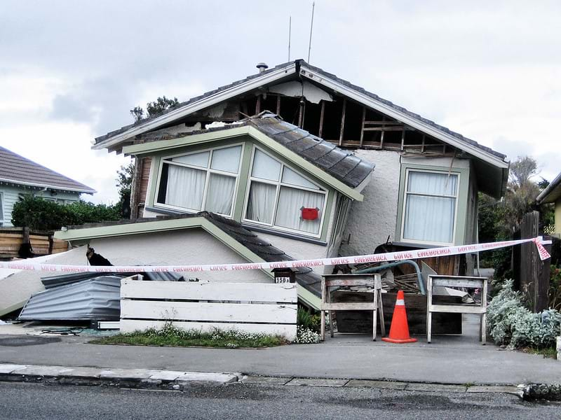
In 1923 near Kobe, Japan, 140,000 people were killed by nature. The cause of this natural destruction was a massive earthquake! How does an earthquake happen? Well, the Earth's crust is made up of tectonic plates, which lock together like the pieces of a puzzle. The tectonic plates float on the molten rock of the Earth's mantle and move around very slowly. The movement of these plates, which ultimately causes movement of the continents, is called continental drift. The areas where these tectonic plates meet are the regions of the world with the most violent natural events, with respect to earthquakes. This boundary zone sometimes forms mountain ranges or faults — cracks in the Earth that release a tremendous amount of energy which then shakes the Earth and causes earthquakes. Earthquakes, therefore, are basically the result of the tectonic plates meeting and sliding together to create friction and vibrations that not only cause rocks to break but remarkable Earth shaking as well.
Engineers are very concerned with processes that shape the Earth, because they need to be able to design structures (buildings, schools, bridges) to protect humans against natural events such as earthquakes, volcanoes and hurricanes. Engineers design sturdy structures (i.e., buildings, schools and bridges) that can withstand earthquakes and detection devices to predict earthquakes. It is important for engineers to design roads, bridges, structures, airports, dams, sewage systems — and the methods to obtain and filter drinking water — with Earth processes in mind.
Lesson Background and Concepts for Teachers
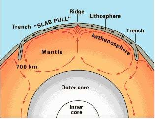
What is the structure of the Earth and what are some of the processes that shape the Earth's surface? Think of the Earth as an onion with five main layers. The first, or inner, part of the Earth is the inner core, which is solid and composed mostly of iron and nickel. Although, scientists cannot actually get to the inner core to test it because it is over 5000 km below the Earth's surface, scientist have predicted that the inner core is solid. The second layer, going from the inside outward, is the outer core, which is molten — or liquid iron and nickel. It lies from 2891 to 5150 km inside the Earth. The third layer that makes up most of the Earth is the mantle. The mantle ranges from 40 to 2900 km deep. It is primarily made of solid rock that is lighter than the iron and nickel core, but heavier than the Earth's crust — the fourth and final layer of the Earth. The crust is 15 - 200 km thick and is made of light materials, which stay on the surface of the Earth. Figure 2 illustrates the different layers of the Earth. Students can solidify their understanding by creating a model earth with the Scale Model of the Earth activity.

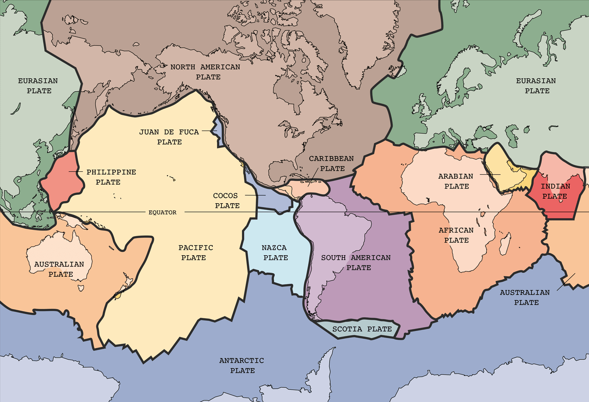
About 30 years ago, geologists developed the theory of plate tectonics — the theory that the crust of the Earth is divided into large plates called tectonic plates, which lock together like the pieces of a puzzle. The tectonic plates are between 200 km (under landmasses) and 15 km (under the ocean) thick. Geologists believe that the tectonic plates are floating on the molten rock of the mantle and moving around very slowly. Each continent has its own tectonic plate (see Figure 3), and the continual slow movement of the plates subsequently causes movement of the continents— called continental drift. Refer to the Drifting Continents activity that pairs a teacher demonstration with a investigation worksheet to help students grasp the concept of continental drift.

Scientists believe that convection currents in the molten rock under the crust account for the movement of the continents. Convection currents are currents, or movements, of liquid that occur because of differences in temperature. As the hot molten rock closest to the outer core of the Earth rises toward the crust, it cools slightly. The cooler molten rock is denser, so it sinks, creating a circular current similar to a pot of boiling soup.
The boundaries where the tectonic plates meet are the areas of the world with the most violent natural earthquake activity. When the plates grind against each other along plate boundaries, the rocks are under so much pressure that sometimes they heat up and fold, creating mountain ranges, hills and valleys. The intense pressure at plate boundaries can also cause rocks to snap and break — forming cracks in the Earth, or faults. When faults are formed, a tremendous amount of energy is released, which shakes the Earth and causes earthquakes.
There are three main types of faults: transcurrent, normal and reverse faults. Transcurrent faults move sideways creating earthquakes. The San Andreas Fault in California is an example of a transcurrent fault. In normal faults, the tectonic plates either move apart from one another or towards each other causing a block of Earth to fall between the two plates. With a reverse fault, a block of Earth is pushed upwards and sometimes over the tectonic plate. Refer to the Faulty Movement activity to help students understand the difference and characteristics of the previously described three types of faults.
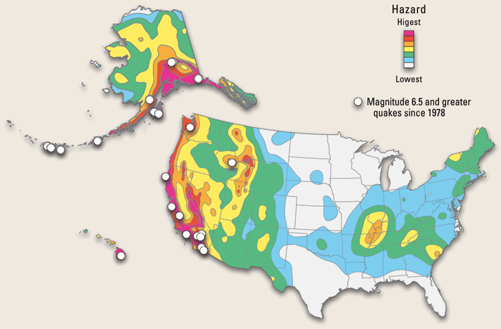
The U.S. Geological Survey has created a map of the United States to help identify areas that are naturally prone to more earthquake activity (see Figure 4). Through their historical assessment of earthquake activity, they are able to predict which areas of the U.S. are likely to experience high, medium, low or little to no earthquake activity. Such a map assists engineers in developing the best structure to withstand these naturally occurring events.

Associated Activities
- Scale Model of the Earth - Students explore the Earth by creating a clay model.
- Drifting Continents - This is a teacher-led demonstration of continental drift. Students also extend their knowledge of drift by doing a math activity in which they calculate continental drift over time.
- Faulty Movement - Students make models of the three different types of faults. They will learn how land moves when blocks of rock slide sideways, apart or towards each other.
Lesson Closure
Ask students what causes earthquakes. (Answer: Earthquakes occur when friction between tectonic plates causes rocks to break along fault lines.) Ask students what are the societal and environmental affects of earthquakes. (Answer: Earthquakes alter the makeup of our Earth's surface. Also, each year, earthquakes cause millions of dollars of damage to cities and contribute to the injury or death of many people.) Ask students whether they think their school is at risk for an earthquake. (Answers will vary depending on where you live. Revisit Figure 4, the earthquake hazard map of the U.S.). Talk to students about how they could tell if they are at risk of an earthquake. Have there been many earthquakes in your area in the past? Do you live in a high-risk or low-risk area? Could you utilize the internet to see where earthquakes are currently occurring? (Answer: Yes, students can visit https://earthquake.usgs.gov/earthquakes/ to observe current earthquake activity.)
Vocabulary/Definitions
continental drift: The theory that the continents have drifted apart.
convection current: A current, or movement, in a liquid or gas that is caused by differences in temperature and density.
core: The innermost layer of the Earth which is solid, comprised of mostly iron.
crust: The outermost and thinnest layer of the Earth also called the lithosphere.
fault: A crack in the Earth. There are a lot of faults underlying plate boundaries.
lithosphere: Also called the crust (litho meaning "stone" in Greek).
mantel: The third layer of the Earth made of molten rock.
molten: Melted.
normal fault: A fault in which a block of rock falls down between the edges of the crack.
outer core: The second layer of the Earth which is a liquid, mostly molten iron.
plate boundaries: The boundary between two tectonic plates.
plate tectonics: The theory that the Earth's crust is made of plates which move relative to one another.
reverse fault: A fault in which a block of rock is pushed up or over two tectonic plates moving toward each other.
tectonic plate: The interlocking pieces of the Earth's crust.
transcurrent fault: A fault, or crack, where the tectonic plates move sideways.
Assessment
Pre-Lesson Assessment
Journal: If students do not already have a science journal, this unit is perfect for trying one! Print out journal sheets and KWL charts each time you do an activity for the students to keep in a binder/folder.
Discussion Questions: solicit, integrate and summarize student responses.
- Has anyone ever been in an earthquake?
- Has anyone seen an earthquake on TV?
- What might an earthquake feel like?
Post-Introduction Assessment
Question/Answer: Ask students questions and have them raise their hands to respond. Write answers on the board.
- What is the Earth's crust made up of? (Answer: tectonic plates)
- What is the movement of continents as a result of the shifting of tectonic plates called? (Answer: continental drift)
- What happens at the boundaries of tectonic plates? (Answers: earthquakes, the most violent natural events, the formation of mountain ranges or faults)
- What is a fault? (Answer: A fault is a crack in the Earth's crust that releases a tremendous amount of energy, which shakes the Earth and causes earthquakes.)
- What causes earthquakes? (Answer: Earthquakes are the result of tectonic plates meeting and sliding together to create friction, which then causes tremendous Earth shaking.)
- Why do engineers care about earthquakes? (Answer: Engineers are very concerned with processes that shape the Earth, because they need to be able to design structures — buildings, schools, bridges, for example — to protect humans against natural events such as earthquakes, volcanoes and hurricanes.)
- In taking earthquakes into consideration, what else do engineers design? (Answer: Engineers also design roads, bridges, houses, schools, office buildings, airports, dams, sewage systems, and the methods necessary to obtain and filter drinking water.)
Lesson Summary Assessment
Bingo: Provide each student with a sheet of paper containing a list of the lesson vocabulary terms. Have each student walk around the room and find a student who can define one vocabulary term. Students must find a different student for each word. When a student has all terms completed s/he shouts "Bingo!" Continue until two or three (or most) students have bingo. Ask the students who shouted "Bingo!" to give definitions of the vocabulary terms.
Lesson Extension Activities
Talk to students about what to do in the event of an earthquake. For information on earthquake safety tips and an online quiz about earthquake safety tips, see the following link: http://www.quakehold.com/emergency-preparedness-disaster-preparedness-earthquake-preparedness/disaster-preparedness-earthquake-preparedness-preptest.html.
Have students choose an historical earthquake and write a small report on the facts of the earthquake. They should report on the time, date and location of the earthquake and what the effects of the earthquake were.
Subscribe
Get the inside scoop on all things Teach Engineering such as new site features, curriculum updates, video releases, and more by signing up for our newsletter!More Curriculum Like This

Students investigate how mountains are formed. Students learn that geotechnical engineers design technologies to measure movement of tectonic plates and mountain formation, as well as design to alter the mountain environment to create safe and dependable roadways and tunnels.

Students learn about the causes, composition and types of volcanoes. They begin with an overview of the Earth's interior and how volcanoes form. Once students know how volcanoes function, they learn how engineers predict eruptions.

Students learn about major landforms (such as mountains, rivers, plains, valleys, canyons and plateaus) and how they occur on the Earth's surface. They learn about the civil and geotechnical engineering applications of geology and landforms, including the design of transportation systems, mining, ma...

Students are introduced to the fabulous planet on which they live. They learn how engineers study human interactions with the Earth and design technologies and systems to monitor, use and care for our planet's resources wisely to preserve life on Earth.
References
Curtis, Neil and Michael Allaby. Visual Factfinder. Planet Earth. New York: Kingfisher Books, Grisewood and Dempsey and Co., 1993.
Press, Frank and Raymond Siever. Understanding Earth. New York: W.H. Freeman and Company, 1998.
Silverstein, Alvin, Virginia Silverstein and Laura Silverstein Nunn. Plate Tectonics. Brookfield, CT: Twenty First Century Press, 1988.
Taylor, Barbara. Earth Explained. A Beginners Guide to Our Planet. New York: Henry Holt and Company, 1997.
Walters, Martin and Felicity Trotman. Earth Sciences; A Prentice Hall Illustrated Dictionary. New York: Prentice Hall, 1992.
http://projects.crustal.ucsb.edu/understanding/
https://earthquake.usgs.gov/earthquakes/
http://www.quakehold.com/emergency-preparedness-disaster-preparedness-earthquake-preparedness/disaster-preparedness-earthquake-preparedness-preptest.html
http://earthquake.usgs.gov/regional/sca/past.php
http://pubs.usgs.gov/publications/text/dynamic.html#anchor10790904
Copyright
© 2004 by Regents of the University of Colorado.Contributors
Jessica Todd; Melissa Straten; Malinda Schaefer Zarske; Janet YowellSupporting Program
Integrated Teaching and Learning Program, College of Engineering, University of Colorado BoulderAcknowledgements
The contents of this digital library curriculum were developed under a grant from the Fund for the Improvement of Postsecondary Education (FIPSE), U.S. Department of Education and National Science Foundation GK-12 grant no. 0338326. However, these contents do not necessarily represent the policies of the Department of Education or National Science Foundation, and you should not assume endorsement by the federal government.
Last modified: February 13, 2026


User Comments & Tips