
Nidy-Gridy: Using Grids and Coordinates
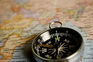 What's the location?Copyright Pixabay http://pixabay.com/en/compass-navigation-map-direction-390054/
Normally we find things using landmark navigation. When you move to a new place, it may take you awhile to explore the new streets and buildings, but eventually you recognize enough landmarks and remember where they are in relation to each other. However, another accurate method for locating places and things is using grids and coordinates. In this activity, students will come up with their own system of a grid and coordinates for their classroom and understand why it is important to have one common method of map-making.
Engineers often use landmarks for navigation. For example, when construction materials technicians obtain test concrete samples from a pour, they use landmarks to inform engineers of the samples' locations. If the tests later show that the concrete does not meet the original specifications, the engineer must decide how to proceed. Engineers also use grids and coordinates frequently. They look for relationships between variables as plotted on graphs, to inform effective designs and clearly communicate those designs with others.
After this activity, students should be able to understand:
- How to make predictions and use scientific investigation to verify hypotheses.
- Understand grids and coordinates are useful for location, navigation, and transportation in general
- The concepts of latitude and longitude, reading and interpreting scales, and creating a coordinate system
- HS.3.1.a Summarize, represent, and interpret data on a single count or measurement variable.
Grades 9-12
Do you agree with this alignment? - 7.1.1 Proportional reasoning involves comparisons and multiplicative relationships among ratios.
Grade 7
Do you agree with this alignment?
- Describe methods and equipment used to explore the solar system and beyond
Grade 8
Do you agree with this alignment?
- CCSS.Math.Content.6.RP.A.1 Understand the concept of a ratio and use ratio language to describe a ratio relationship between two quantities.
Grade 6
Do you agree with this alignment? - CCSS.Math.Content.7.G.A.1 Solve problems involving scale drawings of geometric figures, including computing actual lengths and areas from a scale drawing and reproducing a scale drawing at a different scale.
Grade 7
Do you agree with this alignment? - CCSS.Math.Content.HSN-Q.A.1 Use units as a way to understand problems and to guide the solution of multi-step problems; choose and interpret units consistently in formulas; choose and interpret the scale and the origin in graphs and data displays.
Grades 9-12
Do you agree with this alignment?
- STEL-3G Explain how knowledge gained from other content areas affects the development of technological products and systems.
Grades 6-8
Do you agree with this alignment?
Each student should have:
- 1 Map Your Class blank graph paper handout
- 1 Relative Sizes Worksheet handout
- 1 Nidy Gridy Worksheet handout
- 40-50 feet of string (two pieces long enough to reach from wall to wall of the classroom; can be share among students)
- Latitude and Longitude Cards
- Pencil
- Tape measure
What if you were blindfolded, flown to another country and dropped off in the middle of a city. How would you know where you are? (Possible answers: Ask someone? Purchase a map? Guess at the language being spoken?) In this situation, there are no familiar landmarks in which to orient yourself! If you do not speak the language, your best chance is to purchase a map, and see if you can match the new landmarks around you to the map. But, there could be another problem. What if you do not know how to use a map? Although there is some skill to reading a map, most people, with a little practice, can uses a map to successfully navigate their way around an unfamiliar city. This activity will teach you how to understand and use map grids and learn the symbols common to most standard maps.
Background
How can we locate where we need to go if we have never been there before? How do we determine the best way to get there? If there was a huge grid with numbers painted on the ground throughout any given city, and you knew the coordinates of your destination, you could just follow the increasing or decreasing number to your desired location. Unfortunately, grids are not painted on cities' grounds (although sometimes numbered streets come close), but if you have a map and know where you are on that map, you can easily find another location by moving the correct distances indicated by the grid on the map. The common system used for distances on maps all over the world is called latitude (distance North-South) and longitude (distance East-West).
Before the Activity
Read through all the steps of the activity and have a few relevant questions ready. Check your room size in advance using a tape measure. Print the Lat /Long cards beforehand for the students.
With the Students
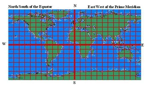 Figure 1. A rectangular map of the world with longitude and latitude lines displayed in a grid, allowing for the identification of any point on Earth.Copyright Matt Lippis, University of Colorado at Boulder, 2003.Ask the students if they think they can find any spot in the classroom? (Answer: Yes, they can.) Ask where the chalk (or white) board is located? (Possible answers: right there, students may point, etc.) Ask them where you are standing? (Same answers and pointing as above.) Ask the students where you are in relation to other objects in the classroom? (Possible answers: next to the board, next to that desk, etc.) Once several students have described your position, ask if you are a good landmark. (Answer: not really). Walk 5-10 feet (several meters) away. Point out to the students that you just moved! Now where are you? (As students attempt to answer, keep moving.) Tell the students that really good landmarks do not move.
Now ask the students if they can find this spot in the classroom: 5,3 (write it on the board)? Tell them that these numbers represent a precise spot in the classroom. Why can't they find it? They should know that they have no basis or reference for what the numbers mean. Tell them that it is obvious to you what the numbers represent, but how can you possibly convey that information to them? (Answer: draw a map.) Tell them a map is a great idea, and that they will have to come up with a system and draw their own maps.
Part I
- Give each student a blank "Map Your Class" graph sheet.
- Tell them they have 5 minutes to draw objects in the classroom into the box on the sheet. Instruct them to draw the walls first. They should put a star on their desk when they have finished drawing it.
- When the 5 minutes is up, have the students choose one corner of their drawn room, and mark one wall leading from that corner as "x" and other one as "y."
- Have the students put a numbering system on the x- and y-labeled walls (any way they want: up, down, 3 numbers on a side, 25 numbers on a side, etc.)
- Now have students note the x and y coordinates of their desk on the "Grid Worksheet" using the numbering system on their map. If their desk does not line up with an exact number on either their x or y axis, they can round up to the nearest value or estimate the best number between the nearest values (for example, if their desk falls between 1 and 2, they would write 1.5).
- Have the students trade worksheets with their neighbor. Ask them to (physically) locate the x and y position written on their neighbor's Grid Worksheet using their own map and numbering system.
- Using their own map, students will position themselves at the coordinates written by their neighbor. (Instruct students to do this quietly, as it may be confusing early on because some students may not actually have their neighbor's numbers on their own map grid. If they do not, tell them to go to the closest number they do have written on their grid (i.e., if they receive a worksheet with an x value of 50 and the x-axis on their map only goes to 20, they should just proceed to 20).
- Return to desks and trade back worksheets.
Part II
- Hand out the "Relative Sizes" worksheets, and complete the exercise with the students.
- Ask helpers who have been working quietly to measure the classroom walls using the tape measure.
- Give each student a new blank "Classroom "Graph worksheet.
- Decide as a class how the classroom dimensions will fit best on the graph paper.
- Draw in the walls.
- Decide as a class how to set the coordinates, and decide how many divisions you will make along each wall. (For a globe-like grid you will need 90 degrees north, 90 degrees south, 180 degrees east, and 180 degrees west. This puts the center of the room as 0 degrees. A simpler grid system would be to choose one corner as 0,0.)
- Measure the divisions along the two walls moving away from 0,0, and mark them with a piece of tape.
- Have each student stand next to a piece of tape and make a "Lat Card" or "Long Card" to post there as appropriate.
- Using two pieces of string (long enough to touch opposite walls of the class), have students take turns in groups of four measuring the Lat and Long of their four desks.
- Each student should record on their "Grid Worksheet" what their desks' Lat and Long are for the common class map.
- Now play "Map Bingo." Using the common classroom map as a bingo grid for the student's desks, the teacher will call out coordinates and ask students questions. If a student answers correctly, s/he stands up as a bingo chip. Once a full desk row, column or diagonal is standing, the class wins.
Pre-Activity Assessment
Discussion Questions: Solicit, integrate and summarize student responses.
- Ask the students if they think they can find any spot in the classroom? (Answer: Yes, they can.) Ask where the chalk (or white) board is located? (Possible answers: right there, students may point, etc.) Ask them where you are standing? (Same answers and pointing, as above.)
- Ask the students where you are in relation to other objects in the classroom? (Possible answers: next to the board, next to that desk, etc.) Once several students have described your position, ask if you are a good landmark. (Answer: not really). Walk 5-10 feet (several meters) away. Point out to the students that you just moved! Now where are you? (As students attempt to answer, keep moving.) Tell the students that really good landmarks do not move.
Activity Embedded Assessment
Worksheets: Use the Nidy Gridy and Relative Sizes worksheets to help students follow along with the activity
Discussion Questions: Ask the students and discuss as a class:
- How many students actually ended up at the desk of their neighbor? (Answer: Probably not many.)
- What went wrong? (Possible answers: different numbering systems, different walls for x and y axis, not everyone marked the same landmarks on their maps, etc.)
Post-Activity Assessment
Bingo: Using the common classroom map as a bingo grid for the students' desks, the teacher will call out coordinates and ask students questions. If a student answers correctly, s/he stands up as a bingo chip. Once a full desk row, column or diagonal is standing, the class wins.
Ask the students to use caution when moving around the room, as there will be many students selecting the same corner for their grid.
If you are using a lat/long system, use the cards given and place the 0,0 in the middle of the room. If you are using x and y, use a grid system with numbers on the wall. This could be a good way to make this two separate activities: one map with x and y, and the next time a map with long/lat.
Research existing map symbols. Ask students to determine if there is one universal set or individual symbols (i.e., different from country to country)?
Have students look at common coordinates on a city map and write a journal entry about how they think the map coordinates were determined. They can share their thoughts in a small group or with the whole class.
- For 6th and 7th grades, conduct activity as is.
- For 8th grade, have the students calculate the exact relative sizes for all large objects in the room for the room dimensions on the graph paper.
- Plot Your Course - Navigation
- Where Is Here?
- Nidy-Gridy: Using Grids and Coordinates
- Northward Ho! Create and Use Simple Compasses
- Find Your Own Direction
- How to be a Great Navigator!
- Navigating by the Numbers
- Accuracy, Precision and Errors in Navigation: Getting It Right!
- Topo Map Mania!
- Getting to the Point
- Navigational Techniques by Land, Sea, Air and Space
- Navigating at the Speed of Satellites
- GPS on the Move
- Not So Lost in Space
- Where Is Here?
Contributors
Jeff White; Matt Lippis; Penny Axelrad; Janet Yowell; Malinda Schaefer Zarske
Supporting Program
Integrated Teaching and Learning Program, College of Engineering, University of Colorado Boulder
Acknowledgements
The contents of this digital library curriculum were developed under a grant from the Fund for the Improvement of Postsecondary Education (FIPSE), U.S. Department of Education, and National Science Foundation GK-12 grant no 0338326. However, these contents do not necessarily represent the policies of the Department of Education or National Science Foundation, and you should not assume endorsement by the federal government.
Copyright
2004 by Regents of the University of Colorado.