
Classroom Triangles
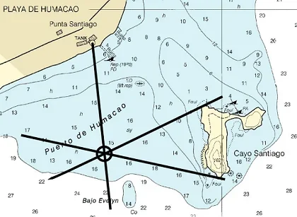 Students use bearing measurements to triangulate and determine objects' locationsCopyright U.S. NOAA. Wikimedia Commons
Students use bearing measurements to triangulate and determine objects' locations. Working in teams of two or three, they must put on their investigative hats as they take bearing measurements to specified landmarks in their classroom (or other rooms in the school) from a "mystery location." With the extension activity, students are challenged with creating their own maps of the classroom or other school location and comparing them with their classmates' efforts.
Engineers use triangulation technology for many applications. For example, triangulation calculations are used for shape reconstruction of 3D geographic objects such as aquifers, ocean currents and weather fronts. Triangulation calculations are used in medical devices to detect heart rhythm disorders. Triangulation is also used in manufacturing or prototyping processes that create solid objects of polymer materials from the information provided on computer drawings.
After this activity, students should be able to:
- Describe how to use a compass to do triangulation and determine their location,
- Identify the intersection of two points,
- Determine a landmark on a map
- Explain the relationship between triangulation technology and other fields of study (such as mathematics)
- 8.4.2 Direct and indirect measurement can be used to describe and make comparisons.
Grade 8
Do you agree with this alignment? - 7.4.1.a.iii Construct triangles from three measures of angles or sides, noticing when the conditions determine a unique triangle, more than one triangle, or no triangle.
Grade 7
Do you agree with this alignment?
- Describe methods and equipment used to explore the solar system and beyond
Grade 8
Do you agree with this alignment?
- CCSS.Math.Content.7.G.A.1 Solve problems involving scale drawings of geometric figures, including computing actual lengths and areas from a scale drawing and reproducing a scale drawing at a different scale.
Grade 7
Do you agree with this alignment? - CCSS.Math.Content.7.G.A.2 Draw (freehand, with ruler and protractor, and with technology) geometric shapes with given conditions. Focus on constructing triangles from three measures of angles or sides, noticing when the conditions determine a unique triangle, more than one triangle, or no triangle.
Grade 7
Do you agree with this alignment?
- STEL-3G Explain how knowledge gained from other content areas affects the development of technological products and systems.
Grades 6-8
Do you agree with this alignment?
Each student needs:
- 1 copy of the Classroom Triangles Worksheet
- pencil
- graph paper
- ruler
- compass (students may share if necessary)
- tape measure (students may share if necessary)
You have a problem — you think. You know where "something" is, but you do not know where YOU are. So, how can you even begin to determine your location if you do not have a clue as to your whereabouts? You can use triangulation to determine your location. Triangulation is based on finding an unknown location using angle measurements to two known locations. Mathematically, the two known positions define the two vertices (and length of the one side) of a triangle, and the two bearing measurements define two of the angles of the triangle. To get a clearer picture of this process, assume you know where your home is, you know where the movie theatre is, but you do not know how to describe where your school is located. Luckily, you have a compass and a map. You can take a bearing measurement from the school to the cross streets nearest your home and the movie theatre, triangulate the two and determine the location of your school. If you can draw a straight line, then finding your school's location is as simple as 1,2,3!
If you are not lost, for what other reasons would you need to know about and how to take bearing measurements for the purpose of triangulation? Mountaineers, for example, need to know this information so that they may safely hike in the mountains and not get lost or put themselves in danger. Engineers use bearings to determine where to build roads, lay underground wires and pipes and construct bridges and dams. This activity teaches you how to take a bearing measure and apply triangulation to determine locations in the classroom. Afterwards, you should be able to use a map and a compass to determine many unknown locations.
Before the Activity
- Take 3-4 bearing measurements to objects in the classroom from one location (important that you do this before your students begin this activity). Take three bearing measurements of each object from one "mystery" location that the students will try to figure out.
- Create a classroom map. On a piece of graph paper create a scale that maps one square of the paper to a reasonable length in the classroom. You can use a tape measure, or if there are square tiles on the floor, you can count tiles and fractions of a tile.
- Determine the direction to magnetic north in your classroom. Pick the wall that is most directly to the north as "classroom north." You should orient your classroom map so that the walls closest to north-south are on the left and right sides, and the closest to east-west walls are on the top and bottom. Draw a pseudo magnetic declination indication on your class map that shows which way magnetic north points with respect to your classroom north.
- Draw the outline of the room on the paper, and mark several fixed landmarks that are easy to sight. You can use things like the edge of a desk, the doorknob, a specific shelf of a bookshelf or the edge of the chalkboard. Alternatively you could hang up "markers" on the walls as your landmarks. Make sure that the landmarks are correctly placed on the classroom map, and make two or more copies for each team.
- Practice taking a bearing measurement from one location in the classroom to each of the landmarks, making the "declination" adjustment and figuring out where you are. Be sure to keep at least one "clean" copy of the classroom map, as you will be giving each student a copy. It is advised to make a teacher's copy which shows the bearings.
With the Students
- Hand out a copy of the classroom map that you created.
- Illustrate on the chalk/white board how to draw a bearing line on the map through the landmark and how to find the intersection of two bearing lines. Identify the x, y (horizontal and vertical) coordinates of the intersection, and show them the location in the classroom from where the measurements were taken. Have the students explain in their own words how to take a bearing.
- Give the class the bearing measurements that you made from an interesting point in the classroom to three landmarks. Have the students work in teams of two or three to figure out the location using triangulation.
- Hand out the Classroom Triangles Worksheet to each student.
- Now have them use a compass to take their own bearing measurements to classroom landmarks, and mark their location on the worksheet. They can check their answers using a tape measure or by counting floor tiles.
- Discuss the results of the activity. Ask students what they learned. Did they have trouble finding two or three bearings? Ask the students how they decided which landmarks to use. How did this affect their results? (Answer: If the landmarks are almost along the same line, you do not get very reliable results. If the landmarks are at close to 90 degrees apart, you get the best results.) If they sited to three landmarks, how big was their triangle that bounded their position?
Pre-Activity Assessment
Activity Review: With students, review activity topic and discuss findings as a class.
- Review how to take a bearing. Pass out compasses to each student (or pair of students) and go over the steps of how to take a bearing, using the front of the classroom or the teacher's desk.
- Have students volunteer to explain how to take a bearing in their own words.
Activity Embedded Assessment
Worksheet: Have the students complete the activity worksheet; review their answers to gauge their mastery of the subject.
Post-Activity Assessment
Pairs Check: After students finish working individually on worksheets, have them compare answers with a peer, giving all students time to finish the worksheet.
- Have them check for location accuracy using their compass and the known bearings.
Discussion/Questions: Ask the students and discuss as a class:
- What did you learn?
- Did you have trouble finding a location using two or three bearings?
- How did you decide which landmarks to use? How did this affect your results? (Answer: If the landmarks are almost along the same line, you do not get very reliable results. If the landmarks are at close to 90 degrees apart, you get the best results.)
- If you sited to three landmarks, how big was your triangle that bounded the position?
Hunt for Red October: Tell students about the movie "The Hunt for Red October." In this movie the submarine loses power to its navigation equipment. Using a map, one crew member gives the captain some bearings and distances to get them through a dangerous ravine. The crew member has to get his bearings just right or the submarine will crash.
- For this activity, have the students create their own dangerous ravine trail map and write instructions for how someone could navigate through it. For example, if using graph paper, 1 block could equal 1 mile. The student's directions might read "First, go N40 for 6 blocks" and so on. Have the students exchange maps and see if they can follow each other's directions and make it through the ravine.
When you draw the classroom map, make sure to leave space between the walls and the edge of the paper. If the classroom is very skewed relative to north, it might be very confusing to take accurate bearing measurements.
Also when drawing the classroom map, select objects that are roughly at waist to chest level so that the students can easily take accurate bearing measurements. Use things like the edge of a desk, a specific shelf of bookshelf, the doorknob, or the edge of the chalkboard.
Working in teams of two, have students create a classroom map. On a piece of graph paper, have them create a scale that maps one square of the paper to a reasonable length in the classroom. They can use a tape measure, or if there are square tiles on the floor, have them count tiles and fractions of a tile. Have students indicate north on their maps and the location of different classroom objects and take the bearing measurement from specific locations. Students should compare maps with other teams and discuss their observations/measurements as a class.
- For lower grades, have students work in groups to complete the worksheet.
- For upper grades, have students work alone to complete the worksheet.
- Plot Your Course - Navigation
Contributors
Matt Lippis; Penny Axelrad; Janet Yowell; Malinda Schaefer Zarske
Supporting Program
Institute of Navigation and Integrated Teaching and Learning Program, College of Engineering, University of Colorado Boulder
Acknowledgements
The contents of this digital library curriculum were developed under a grant from the Satellite Division of the Institute of Navigation (www.ion.org) and National Science Foundation GK-12 grant no. 0338326.
Copyright
2004 by Regents of the University of Colorado.