
Triangulate: Topos, Compasses and Triangles, Oh My!
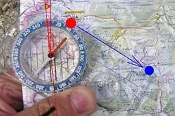 A compass and map are used to determine location.Copyright Wikimedia Commons http://commons.wikimedia.org/wiki/File:CompassUseMapMarked.jpg
In this activity, students learn how to actually triangulate using a compass, topographical (topo) map and view of outside landmarks. It is best if a field trip to another location away from school is selected. The location should have easily discernable landmarks (like mountains or radio towers) and changes in elevation (to illustrate the topographical features) to enhance the activity. A national park is an ideal location, and visiting a number of parks, especially parks with hiking trails, is especially beneficial.
Triangulation technology is used for many applications. Engineers use the concepts of triangulation to design non-contact distance measurement devices that use lasers instead of mechanical measurements. These optical triangulation sensors take very accurate measurements quickly. These devices are especially good in situations in which the surface being measured is delicate, tiny, moving or in some way impossible to measure physically (the width of a volcano opening).
After this activity, students should be able to:
- Read elevation lines,
- Use a compass to locate landmarks on a map
- Identify the major features in topographical maps.
- Understand how triangulation technology is used in many fields of engineering
- HS.3.1.a Summarize, represent, and interpret data on a single count or measurement variable.
Grades 9-12
Do you agree with this alignment? - 7.1.2.c Solve real-world and mathematical problems involving the four operations with rational numbers.
Grade 7
Do you agree with this alignment?
- Describe methods and equipment used to explore the solar system and beyond
Grade 8
Do you agree with this alignment?
- CCSS.Math.Content.6.NS.B.3 Fluently add, subtract, multiply, and divide multi-digit decimals using the standard algorithm for each operation.
Grade 6
Do you agree with this alignment? - CCSS.Math.Content.7.G.A.1 Solve problems involving scale drawings of geometric figures, including computing actual lengths and areas from a scale drawing and reproducing a scale drawing at a different scale.
Grade 7
Do you agree with this alignment? - CCSS.Math.Content.7.G.A.2 Draw (freehand, with ruler and protractor, and with technology) geometric shapes with given conditions. Focus on constructing triangles from three measures of angles or sides, noticing when the conditions determine a unique triangle, more than one triangle, or no triangle.
Grade 7
Do you agree with this alignment? - CCSS.Math.Content.HSG-CO.D.12 Make formal geometric constructions with a variety of tools and methods (compass and straightedge, string, reflective devices, paper folding, dynamic geometric software, etc.). Copying a segment; copying an angle; bisecting a segment; bisecting an angle; constructing perpendicular lines, including the perpendicular bisector of a line segment; and constructing a line parallel to a given line through a point not on the line.
Grades 9-12
Do you agree with this alignment?
- STEL-3G Explain how knowledge gained from other content areas affects the development of technological products and systems.
Grades 6-8
Do you agree with this alignment?
Each student should have:
- A copy of Topo Worksheet 1
- A copy of Topo Worksheet 2
- pencil
- compass (students may share if necessary)
- topographical map of area (students may share if necessary)
Once in the mountains, you might know where you are, but do you really know specifically where you are? Probably not. Using a topographical map, you can precisely pinpoint your location in all types of terrain. But, to do this, you need to know how to read a topo map and how to properly transfer that knowledge to determine your location. True, engineers have designed a device, the GPS receiver, to assist you with finding you location while in the wilderness or while driving in unknown areas, but what if you do not have such a device with you? You only have a compass and topographical map. Well, simply knowing how to use a compass and how to read a topo map will allow you to figure out where you are on your map and how to get to where you need to be.
Our early explorers did not have GPS receivers to rely upon for finding their way around the huge land mass which would eventually become America. Think about how their early use of maps allowed them, and future explorers, to get back to the same location over and over again. Even hundreds of years ago, navigators were using special markings on their maps to indicate changes in elevation and terrain, making it possible to return to the same location or giving them the necessary information to return to their homes. Although reading a topo map can be tricky, with a little practice and knowledge of symbols and compass use, most anyone can use them to their advantage. This activity will give you some basic skills and practice reading topographical maps.
Before the Activity
It is suggested that this activity follow the Classroom Triangles Activity of Lesson 6.
- Several weeks before this activity, find a location for a field trip. The location should have easily discernable landmarks (like mountains or radio towers) and changes in elevation (to illustrate the topographical features) to enhance the use of the activity. A national park would be an ideal location. A national park is an ideal location, and visiting a number of parks, especially parks with hiking trails, is especially beneficial.
- Obtain a topographical map for the area chosen for the field trip. Topographical maps can easily be obtained from any outdoor sports business. Call them first to see if they have topographical maps of the area that you have chosen. The sure way of getting maps is through the U.S. Geological Survey (USGS). They have offices all over the country, and possibly in your area. You can also visit their website at https://www.usgs.gov/ (general information) or https://pubs.er.usgs.gov/ (maps).
They can also be contacted at:
USGS Information Services
Box 25286
Denver CO 80225
1-888-ASK-USGS or 303-202-4700
Fax: 303-202-4693
- Go to the USGS' website, and complete the activities.
- Make a copy of the topographical map for each student.
- Copy the worksheets for the students.
With the Students
Before the Field Trip
- Discuss topographical maps with the students.
Field Trip
- Give each student a copy of the topographical map, and Topo Worksheet 1. Help them become familiar with the topo map using the worksheet.
- Give the students Topo Worksheet 2. Tell them to look for a distinguishing landmark on the topographical map that they might be able to see from an open field. For example, a radio tower or a mountain.
- Tell them to find that landmark outside.
- Have them take a bearing of the landmark. They should be sure to keep the bearing on the compass.
- Have students correct the bearing for the declination. If they corrected the compass permanently, then this requires no more steps. If the compass has not been corrected, then subtract the declination from your bearing. For example, if your compass reads a bearing of 30 degrees, and the declination is +7 degrees, move the compass face to 23 degrees. If the declination is –5, move the compass face to read a bearing of 35 degrees.
- Using the map, have students place the long edge of the compass on the landmark.
- Now have them rotate the compass, keeping the long edge on the landmark, until the meridian lines are lined up with north on the map.
- Using their compass as a straightedge, ask students to draw a line on the map. Their line should go through the landmark. They are located somewhere on that line.
- Now a second line is needed to determine their specific location. Repeat steps 3 through 7 for another landmark.
- The two lines should intersect. This is their location.
- To get a more accurate idea of their location, students may repeat steps 3 through 7 for a third landmark. The three lines will form a triangle, and they will be located somewhere in the triangle.
- When each student is done, have them compare answers with other students.
Pre-Activity Assessment
Worksheet: Have the students complete the Topographical Worksheet 1; review their answers to gauge their mastery of the subject.
Activity Embedded Assessment
Worksheet: Have the students record measurements and follow along with the activity using Topographical Worksheet 2. After students have finished their worksheet, have students check each other's work for accuracy.
Post-Activity Assessment
Presentation: Once back in the classroom, pick three students to each give a 5-minute presentation to the class on what they learned on the field trip. Offer an opportunity for the class to ask the students any questions. If time permits, select more students to share their experience with the class.
To ensure the safety of the students, be sure to enlist the help of an adequate number of chaperones for the field trip. Students should always be with at least one other student while on the field trip.
The students might get confused while shooting their angles to the landmarks. One way to alleviate this confusion is to have the teacher select an initial spot to shoot angles from and mark it. Students could go to that spot in pairs and determine the angle to that landmark. The teacher can work with them and make sure that all answers are consistent from that one spot (i.e., 187 degrees to the radio tower from the big grey rock).
If there is adequate supervision, have the students wander to different spots, 20-50 yards apart. That gives them adequate room to work on their own, and their locations should be different than those of their classmates.
Make sure that they are not wearing metal belt buckles or have anything metallic or magnetic in their pockets, as such items can interfere with the compasses.
- For 6th grade, have students do first worksheet only.
- For 7th and 8th grade, conduct activity as is.
- Plot Your Course - Navigation
- Where Is Here?
- How to be a Great Navigator!
- Navigating by the Numbers
- Accuracy, Precision and Errors in Navigation: Getting It Right!
- Topo Map Mania!
- Getting to the Point
- Classroom Triangles
- Topo Triangulation
- Triangulate: Topos, Compasses and Triangles, Oh My!
- You've Got Triangles!
- Navigational Techniques by Land, Sea, Air and Space
- Navigating at the Speed of Satellites
- GPS on the Move
- Not So Lost in Space
Contributors
Matt Lippis; Penny Axelrad; Janet Yowell; Malinda Schaefer Zarske
Supporting Program
Integrated Teaching and Learning Program, College of Engineering, University of Colorado Boulder
Acknowledgements
The contents of this digital library curriculum were developed under a grant from the Satellite Division of the Institute of Navigation (www.ion.org) and National Science Foundation GK-12 grant no. 0338326.
Copyright
2004 by Regents of the University of Colorado.