
Navigating at the Speed of Satellites
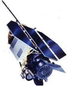 Figure 1. The Roentgen Satellite (ROSAT) is an Earth-Orbiting X-ray Observatory.Copyright http://heasarc.gsfc.nasa.gov/docs/xte/xte_1st.html
For thousands of years, navigators have looked to the sky for direction. Today, celestial navigation has simply switched from using natural objects to human-created satellites. A constellation of satellites, called the Global Positioning System, and hand-held receivers allow for very accurate navigation. In this lesson, students investigate the fundamental concepts of GPS technology — trilateration and using the speed of light to calculate distances.
Creating GPS required contributions from many engineering disciplines. Mechanical engineers created GPS equipment able to perform reliably in the unique environment of space. Electrical engineers designed computers, circuit boards, power systems and wiring. Aerospace engineers determined the satellite arrangement around the Earth and designed their orbits. Software engineers wrote computer programs so that the satellites operate on their own and transmit useful data to Earth receivers.
After this lesson, students should be able to:
- Understand the basic concepts that make GPS work: that distance is determined by knowing the time it takes a signal to travel from a satellite to a receiver.
- Analyze error and its effect on real-world problems
- Understand early navigation technologies and how advancements in technology have improved our ability to navigate
- Recognize that GPS required contributions from many engineering disciplines
- HS.2.4.c.i Solve linear equations and inequalities in one variable, including equations with coefficients represented by letters.
Grades 9-12
Do you agree with this alignment? - 7.1.2.c Solve real-world and mathematical problems involving the four operations with rational numbers.
Grade 7
Do you agree with this alignment?
- Describe methods and equipment used to explore the solar system and beyond
Grade 8
Do you agree with this alignment?
- STEL-3G Explain how knowledge gained from other content areas affects the development of technological products and systems.
Grades 6-8
Do you agree with this alignment? - STEL-6D Engage in a research and development process to simulate how inventions and innovations have evolved through systematic tests and refinements.
Grades 6-8
Do you agree with this alignment?
- MS-ETS1-2 Evaluate competing design solutions using a systematic process to determine how well they meet the criteria and constraints of the problem.
Grades 6-8
This resource focuses on the following Three Dimensional Learning aspects of NGSS:
Science & Engineering Practices- Evaluate competing design solutions based on jointly developed and agreed-upon design criteria.Do you agree with this alignment?
Disciplinary Core Ideas- There are systematic processes for evaluating solutions with respect to how well they meet the criteria and constraints of a problem.Do you agree with this alignment?
Do you agree with this alignment? - Evaluate competing design solutions based on jointly developed and agreed-upon design criteria.
Navigation satellites are like orbiting landmarks. Rather than seeing these landmarks with our eyes, we "hear" them using radio signals. The Global Positioning System is a constellation (or set) of at least 24 satellites that continuously transmit faint radio signals toward the earth. Refer to the associated activity State Your Position for students to discover how several GPS satellites are used to find a position. These radio signals carry information about the location of the satellite and special codes that allow someone with a GPS receiver to measure distance to the satellite. Students can learn how GPS is used to calcuate distance by acting out the part of the GPS signal traveling to the receiver with the associated activity It's About Time. Combining the distances and satellite locations, the receiver can find its latitude, longitude, and height. GPS satellite signals are free and available for anyone to use. GPS receivers are decreasing in cost every year and can be found in sporting good stores, are embedded in cell phones and even in watches.
How does a GPS receiver know how far away the satellites are? Early on, scientists recognized the principle that, given velocity and the time required for a radio signal to be transmitted between two points, the distance between the two points can be computed. In order to do this calculation, a precise, synchronized time of departure and measured time of arrival of the radio signal must be obtained. By synchronizing the signal transmission time to two precise clocks, one in a satellite and one at a ground-based receiver, the transit time could be measured and then multiplied by the exact speed of light to obtain the distance between the two positions.
GPS – The Global Positioning System
GPS is based on satellite ranging. Our position on earth is calculated by measuring our distance from a group of satellites in space. This is done by timing how long it takes a radio signal to reach us from a satellite. The signal travels at the speed of light (186,000 miles per second), so we are able to calculate the distance (Velocity x Time = Distance. For more information, you may refer to the explanation of Dead Reckoning in Lesson 2 of this unit).
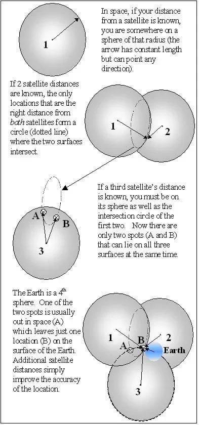 Figure 2. How GPS works.Copyright J. White and M. Lippis, University of Colorado, Boulder, 2003.
GPS satellite ranging allows a receiver to determine its 3-dimensional position: latitude, longitude and height. Because the ranging measurements are based on timing, both the time in the satellite transmitter and the user's receiver have to be coordinated. A GPS receiver measures range to four satellites to determine latitude, longitude, height and this timing correction.
Let's take this one step at a time. For now, assume that the satellite and receiver clocks are already coordinated, and the positions of the satellites are known. If we measure distance to one satellite, we know that we are located on a sphere of that radius, centered on the satellite. With two satellite range measurements, our location is limited to a circle and with three satellites to one of two points. A fourth satellite can be used to find the correct point and to take care of the time coordination.
If it has extra information, a receiver can figure out its position with fewer satellites. For example, if you know that you are on the ocean surface, you can use this piece of information and only three satellites to find your latitude, longitude, and timing. In this case, height is not needed because you already know it.
So, how do we know where the satellites are? All satellites are constantly monitored. They have a 12-hour orbit, and the U.S. Department of Defense is able to monitor the satellites from ground stations around the world. The satellites are checked for errors in their position, height, and speed. These minor errors are caused by gravitational pulls from the moon, sun, and even pressure from solar radiation on the satellite. The satellites transmit special codes for timing purposes, and these codes carry a data message about their exact location. This helps to locate the satellite precisely.
Improvement from previous methods of navigation
GPS provided a welcome improvement from previous methods of navigation, though some of these methods still remain popular. One of the first navigational tools ever invented was the compass. Refined over centuries of use, a typical compass utilizes a magnetized needle that is attracted to the north magnetic pole of the earth (the north magnetic pole is different than the true north pole; consequently, simple magnetic compasses are not extremely accurate). Compasses can be quite inexpensive and easy to use, though they only allow for orientation, that is, they show a user the cardinal directions (north, south, east, west), not location. A popular tool among those navigating ships, though it is rarely used today, was the sextant. This tool allowed users to fairly accurately measure angles among the horizon and celestial bodies such as the sun, moon, and stars to locate their position according to longitude and latitude. While a more useful tool than the compass, the sextant required extensive training for accurate readings and was often not useful when cloudy or when the horizon line wasn't clear. Paper maps are an alternative to GPS that are still prevalent today due to their inexpensive cost, ease of use, and non-reliance on electricity or batteries.
Get things going with a discussion. Ask the students why satellites are a good tool for navigation? (Answer: They are "visible" for thousands of miles. Their orbits, and therefore positions, can be tracked to a high degree of accuracy. They can send information as well as simple location data in their signals.) The idea of using satellites for navigation began with the launch of Sputnik 1 on October 4, 1957. Scientists at Johns Hopkins University's Applied Physics Laboratory monitored the satellite. They noticed that when the transmitted radio frequency was plotted on a graph, a characteristic curve of a Doppler shift appeared. By studying the change in radio frequency as the satellite passed overhead, they were able to figure out the orbit of Sputnik. It turns out that you can use this same concept in reverse. If the satellite orbit is known, measurements of frequency shift can be used to find a location on the earth. Knowing the orbits of four satellites, as well as their distances away, a Global Positioning System — or GPS — receiver can trilaterate (to determine a position using intersecting distances) a location.
These are the basic concepts of how a GPS receiver determines a location to the highest accuracy possible. In addition, the signal carries information about the best estimate of the satellite's orbit. The satellite does not know its own orbit; people on the ground have to track the satellite to see how the orbit changes over time. The orbit is predicted for several weeks ahead and this information is then sent to the satellite. If the orbits were not updated, the accuracy of the GPS system would deteriorate. Additionally, the GPS satellites have a certain lifetime on orbit, as their fuel and mechanical parts can only last so long. Satellites can last 10 to 20 years, and sometimes longer, but they must be replaced eventually.
Should we throw away all the old navigation equipment? Does anyone need to learn all those complicated methods of celestial navigation? If you were traveling 100 years into the future, would you take a sextant or a GPS receiver? The GPS system is an easy and accurate navigation tool, but it should not be taken for granted.
- gps
- Global Positioning System.
- satellite
- An object launched specifically to orbit the Earth.
- receiver
- A device that accepts (receives) incoming signals and converts them to a usable form.
- orbit
- The path an object in space follows as it circles the Earth.
- trilateration
- Position determined by intersecting distances.
- triangulation
- The location of an unknown point by the formation of a triangle.
Pre-Lesson Assessment
Discussion Question: Solicit, integrate, and summarize student responses.
- Why are satellites a good tool for navigation? (Answer: They are "visible" for thousands of miles. Their orbits, and therefore positions, can be tracked to a high degree of accuracy. They can send information as well as simple location data in their signals.)
Post-Introduction Assessment
Question/Answer: Ask the students and discuss as a class:
- Is it hard to understand how satellites work? Why or why not? (Answer: Have several students answer and discuss that the satellite is a tool, and while its inner workings may be complicated, its basic actions and uses are not hard to understand. Tell them they will learn more about the workings of satellites in this lesson.)
Lesson Summary Assessment
Discussion Question: Solicit, integrate and summarize student responses.
- If you were traveling 100 years into the future, would you take a sextant or a GPS receiver? Discuss. (Answer: Open question. Possible reasons for not taking a GPS receiver would be: GPS system was not kept up or fails in the future; a new better system has been put in place, and the old receiver is not compatible; if the GPS receiver breaks, the system is useless. Reasons to take a sextant: no batteries required, sun moon and stars will always be there, much easier to fix if something on it breaks.)
- Imagine that you are going on a two-week hiking trip in the Rocky Mountains. Evaluate the four navigational tools (GPS, paper maps, compass, sextant) and determine the pros and cons of each. What are the criteria and constraints of the scenario? Which tool(s) would you take and why? Consider creating a comparison table. (Possible answers: GPS: pros – ease of use, highly accurate for position and elevation; cons – expensive, may run out of batteries, signal may be blocked by mountains; Sextant: pros – purely mechanical (not reliant on electricity), can be very accurate with high level of training, locates longitude & latitude; cons – view of horizon and/or celestial bodies may be blocked, requires high level of training, easy to make errors; Compass: pros – inexpensive, fairly accurate for orientation, does not rely on electricity; cons – may be inaccurate if north magnetic pole not taken into account, does not determine location; Map: pros – inexpensive, fairly easy to use, can show terrain and other geographic features; cons – accuracy depends on the user, may hike out of map range; Possible criteria & constraints – need to be able to rely on a user-friendly, inexpensive tool that will allow you to find your location and approximate elevation)
Homework
Research: Investigate lesson topic and summarize findings.
- Research at home or in a library how the GPS system has changed an aspect of navigation. Present results in class.
A demonstration could be done in the classroom (with three very long pieces of string) to find a hidden item in the class. The instructor must measure and hide an item ahead of time.
Research at home or in a library how the GPS system has changed an aspect of navigation. Present results in class.
Have students come up with their own trilateration measurements on a map or in the classroom.
Set a globe on top of the map. Have students notice that in 3-dimensions, three satellite distances give one possible solution on the globe and one out in space! (Note: you can demonstrate this without numbers and adjust it as you proceed, or you must measure the three distances ahead of time if you want to give the students numbers that work.)
"The ROSAT Satellite." Online image. ROSAT Guest Observer Facility. December 10, 2003. http://xte.gsfc.nasa.gov/docs/rosat/gallery/rosat_sat.html>.
ROSAT Mission: http://www.xray.mpe.mpg.de/>.
About GPS: Dana, Peter H. The Global Positioning System. May 1, 2000. The Geographer's Craft. October 16, 2003. http://www.colorado.edu/geography/gcraft/notes/gps/gps_f.html
GPS Applications Information: How Does GPS Work? 1998. Smithsonian National Air and Space Museum. October 16, 2003. http://www.nasm.si.edu/galleries/gps/work.html>.
NAVSTAR GPS Joint Program Office (SMC/GP) Homepage. July 9, 2003. NAVSTAR Global Positioning System Joint Program Office. http://gps.losangeles.af.mil/
- Plot Your Course - Navigation
Contributors
Jeff White; Matt Lippis; Penny Axelrad; Janet Yowell; Malinda Schaefer Zarske
Supporting Program
Integrated Teaching and Learning Program, College of Engineering, University of Colorado Boulder
Acknowledgements
The contents of this digital library curriculum were developed under a grant from the Satellite Division of the Institute of Navigation (www.ion.org) and National Science Foundation GK-12 grant no. 0338326. However, these contents do not necessarily represent the policies of the NSF and you should not assume endorsement by the federal government.
Copyright
2004 by Regents of the University of Colorado.