
Where Is Here?
In this lesson, students are shown the very basics of navigation. The concepts of relative and absolute location, latitude, longitude and cardinal directions are discussed, as well as the use and principles of a map and compass.
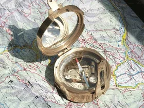 Location can be determined using a compass and map.Copyright Wikimedia Commons http://upload.wikimedia.org/wikipedia/commons/d/d5/Stanley_compass_1.jpg
Some engineers create sophisticated guidance systems. For example, the MapQuest.com website provides detailed maps and directions that were created by computer algorithms and software designed by engineers. Another technology is OnStar — a system installed in vehicles to provide information and services such as stolen vehicle tracking and roadside assistance. The system uses GPS satellite and cellular technology to link the vehicle and driver to a help center. In fact, in recent years, mapping websites like MapQuest and external GPS systems like OnStar have been almost entirely replaced by GPS technology built into smartphones!
After this lesson, students should be able to:
- Explain the concepts of coordinates and cardinal directions.
- Explain the importance of using a common set of symbols and methods when making maps.
- Describe how using and understanding maps and compasses can help determine one's location.
- Explain how navigational technology like global positioning system (GPS) is used in many areas of engineering.
- Describe latitudinal and longitudinal numbers and how to measure distance using those numbers.
- 7.1.2.c Solve real-world and mathematical problems involving the four operations with rational numbers.
Grade 7
Do you agree with this alignment? - 6.3.1.d.ii.2 Describe the nature of the attribute under investigation, including how it was measured and its units of measurement.
Grade 6
Do you agree with this alignment?
- Describe methods and equipment used to explore the solar system and beyond
Grade 8
Do you agree with this alignment?
- STEL-3G Explain how knowledge gained from other content areas affects the development of technological products and systems.
Grades 6-8
Do you agree with this alignment?
- MS-ETS1-1 Define the criteria and constraints of a design problem with sufficient precision to ensure a successful solution, taking into account relevant scientific principles and potential impacts on people and the natural environment that may limit possible solutions.
Grades 6-8
This resource focuses on the following Three Dimensional Learning aspects of NGSS:
Science & Engineering Practices- Define a design problem that can be solved through the development of an object, tool, process or system and includes multiple criteria and constraints, including scientific knowledge that may limit possible solutions.Do you agree with this alignment?
Disciplinary Core Ideas- The more precisely a design task's criteria and constraints can be defined, the more likely it is that the designed solution will be successful. Specification of constraints includes consideration of scientific principles and other relevant knowledge that is likely to limit possible solutions.Do you agree with this alignment?
Crosscutting Concepts- The uses of technologies and any limitations on their use are driven by individual or societal needs, desires, and values; by the findings of scientific research; and by differences in such factors as climate, natural resources, and economic conditions.Do you agree with this alignment?
- All human activity draws on natural resources and has both short and long-term consequences, positive as well as negative, for the health of people and the natural environment.Do you agree with this alignment?
Do you agree with this alignment? - Define a design problem that can be solved through the development of an object, tool, process or system and includes multiple criteria and constraints, including scientific knowledge that may limit possible solutions.
The following topics will be discussed: latitude and longitude; degrees, minutes and seconds; compass and maps; measuring latitude and longitude, the Earth's magnetic field (how a compass works); and global positioning system (GPS). Refer to the associated activity Northward Ho! Create and Use Simple Compasses for students to learn how important magnetic directions are for maps. They also make a basic compass to determine the direction north in the classroom.
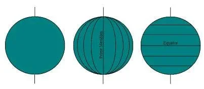 Figure 1. Imaginary lines of longitude (right) and latitude (center) help geographers pinpoint locations on Earth.Copyright 2003 Matt Lippis, University of Colorado Boulder.The measurement that tells you how far you are north or south is called latitude. On a globe, latitude lines appear as parallel rings that wrap the Earth (see Figure 1).
In the Figure 2 map , the surface of the Earth has been flattened and stretched at the top and bottom so that it is rectangular. Here, latitude is shown as horizontal red (or bold) lines, and the equator is shown as a thicker red (or bold) line. All points on any one latitude line are the same distance from the equator. Latitude lines are also called parallels because on a globe, latitude lines never touch each other — they are parallel to one another.
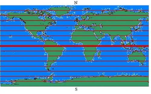 Figure 2. A rectangular map of the world with latitude shown as horizontal red (or bold) lines, and the equator shown as a thicker red (or bold) line.Copyright 2003 Matt Lippis, University of Colorado Boulder.The measurement that tells you how far you are east or west of the Prime Meridian (the thick line that passes through Greenwich, England, and part of Africa) is called longitude. On a globe, longitude lines appear as vertical bands that meet each other at the North and South Poles. They are not parallels (like latitude lines), since they actually all touch each other on the north and south ends of the Earth.
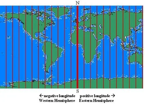 Figure 3. A rectangular map of the world with longitude shown as vertical red (or bold) lines, and the prime meridian shown as a thicker red (or bold) line.Copyright 2003 Matt Lippis, University of Colorado Boulder.In the Figure 2 map, longitude is shown as vertical lines, and the prime meridian is a shown as a thicker red (bold) line. Longitude measures how far east or west along the equator something is located.
Putting the latitude and longitude together, we now have a grid that allows us to identify any point on the Earth.
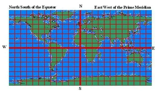 Figure 4. A rectangular map of the world with longitude and latitude lines displayed in a grid, allowing for the identification of any point on Earth.Copyright 2003 Matt Lippis, University of Colorado Boulder.
Measuring Latitude and Longitude
Longitude: Just like a circle, any longitude line (or ring) on the Earth is separated into 360 degrees. It is easiest to visualize along the equator. Looking at the longitude map (Figure 3), there are 24 sections (divided by the red lines), 12 each for the west and east sides. Taking 360 degrees and dividing by 24, we know that each section is 15 degrees across. The reference point (or zero degrees) is from prime meridian, which is located at Greenwich, England. From here you can measure 180 degrees to the west, 0 to –180 degrees. You can also measure 180 degrees to the east, 0 to 180 degrees. Western degrees are always negative, and eastern degrees are always positive. As an example, Boulder, CO, is at –105 degrees longitude.
Latitude: Starting from the equator, you can measure 90 degrees northward and 90 degrees southward. As an example, Boulder, CO, is at 40 degrees N (north). The South Pole is at 90 degrees S (south), and the North Pole is at 90 degrees N. The distance covered by a single degree is too large for practical use, so the system of minutes and seconds was developed. A degree is divided into 60 minutes. For even more detailed use, a minute is divided into 60 seconds. One second of latitude corresponds to about 30 meters on the surface of the Earth.
1 degree = 60 minutes
1 minute = 60 seconds
1 degree = 3600 seconds (60 minutes x 60 seconds)
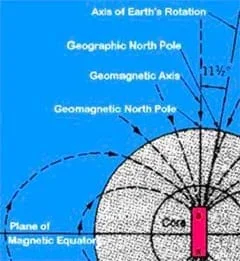 Figure 5. The Earth's magnetic field.Copyright NASA http://rst.gsfc.nasa.gov/Intro/Part2_1a.html
Compasses and the Earth's Magnetic Field
The Earth has a magnetic field that flows from the geomagnetic South Pole to the geomagnetic North Pole. It is this field that causes the alignment of a compass needle, which is magnetized. Luckily, the geomagnetic poles are close to the geographic poles. Therefore, when a compass needle points in the direction of the magnetic field (pointing towards the geomagnetic North Pole) it is pointing pretty close to the geographic North Pole (or, true north).
The slight deviation from the geomagnetic pole and the geographic pole is called the declination. On any good map, the declination for that area will be shown. This way you can calibrate your compass, which is pointing to geomagnetic north, to point at the geographic north, or True North. For younger students, refer to the associated activity Find Your Own Direction where students get the chance to create their own simple compass using thread, needle and water in a bowl — and learn how it works.
The origin of the magnetic field is still a question that has not been fully resolved, but many geophysicists believe it is generated as the rotation of the Earth causes slow movements in the liquid outer core. The magnetic lines of force resemble those that would be formed if there were an imaginary bar magnet extending through the Earth's interior. At the present time, the geomagnetic pole is located 11 degrees of latitude from the geographic pole.
Global Positioning System
The global positioning system (GPS) is a publicly available system that can be used to find a position anywhere on our planet. To use it, you need a device called a GPS receiver. More than 24 satellites continually circle the Earth and broadcast radio signals. A GPS receiver accepts these signals and uses them to determine its, or your, position. GPS receivers are relatively inexpensive, user friendly and accurate. A "no-frills" receiver costs around $100. To determine your position using a GPS receiver, all you have to do is turn it on, wait a few minutes, and the receiver reveals your latitude and longitude. A-top-of-the-line receiver is accurate within approximately 20 ft. of your actual location. Besides all the commercial/industrial uses, they are very popular for personal recreational activities. The GPS tells you where you are, and can keep track of where you have been and help you return there. This is helpful if you are hiking in mountainous areas — on or off trails, boating, or skiing, among other activities. GPS will be covered in more depth in later lessons.
How we know where we are? (Possible answers: Because we can see that we are in the school, we have maps, use a compass, or we just know.) However, that does not tell you where you are. In a classroom, there are many ways to feel comfortable just by knowing where you are in relation to the other places that you already know — this is called landmark navigation.
What if you were in the middle of the ocean? All you can see is water all the way to the horizon in every direction! How do you know where you are now? (Possible answers: Maps? Perhaps a savvy student suggests: Stars!)
(Draw a box on the chalkboard and put a few waves in it.) Would this this map be helpful to you? (Answer: No) Is there anything around you that you can see and recognize? (If no student has mentioned it yet, suggest stars to help determine where they are.) Refer to the associated activity Nidy-Gridy: Using Grids and Coordinates for students to learn the importance of making maps that all can understand!
(Draw another box on the chalkboard and put a few stars in it.) How helpful is this type of map? (Listen to student suggestions.) Even if you recognize patterns in the stars, there is another problem: almost all of the stars move throughout the night. Only the North Star is fixed.
Using the North Star is a good start to determining your location because you can always find the direction north. However, you can see the North Star from anywhere in the Northern Hemisphere, so you have actually only narrowed your location down to one half of the Earth! Before modern technology, people did navigate using the stars, but it was not easy.
In this unit on navigation, you will learn more about navigating with the stars. Today, you will start by learning to navigate in your own clssroom.
How will you get home after school? (Possible answers: Walk, bus, parents pick up.) What form of navigation do you use to arrive at your house? (Hopefully they will be aware that they will use landmark navigation — navigation through places and things that they recognize, even if it is just to know when to get off the bus.)
Do you know if your house is north, south, east or west from the school? How could you figure it out? (Possible answers: Look at a city map, landmark they can see from the school and their houses, draw a map as they go home, etc.) Do you think that your house has a latitude and longitude? (Answer: Yes) Because you know and recognize landmarks in your neighborhood, you do not need a grid and coordinates to find your house, but what about other people? Often people need a long list of directions to find a house, but every house has a specific latitude and longitude, which is all you need if you have a really good map.
- navigation
- Following a planned course to and from known points.
- latitude
- Latitude is the distance north or south of the equator.
- longitude
- The distance east or west of the prime meridian.
- equator
- The line of 0 degrees latitude.
- prime meridian
- The longitude line that runs through Greenwich, England, and is internationally accepted as the line of 0 degrees longitude.
- cardinal directions
- One of the four principal directions on a compass: north, south, east or west.
- compass
- An instrument that uses a magnetized metal bar to indicate the direction of the Earth's magnetic poles.
- global positioning system or gps
- Based upon a series of satellites that broadcast information down to the Earth's surface, this system allows anyone with a receiver to determine his/her location. A receiver (available to the public) picks up these broadcasts to determine its location.
Pre-Lesson Assessment
Discussion Question: Solicit, integrate and summarize student responses.
- How do we know where we are? (Possible answers: Because we can see that we are in the school, we have maps, use a compass, or we just know.) However, that does not tell you where you are. In a classroom, there are many ways to feel comfortable just by knowing where you are in relation to the other places that you already know — this is called landmark navigation.
Post-Introduction Assessment
Voting: Ask a true/false question and have students vote by holding thumbs up for true and thumbs down for false. Tally the votes, and write the totals on the board. Give the right answer.
- True or False: Is a map all you need to know for you to know where you are anywhere in the world? (Answer: False. A map alone is not enough.)
Lesson Summary Assessment
Flashcards: Each student on a team creates a flashcard with a question on one side and the answer on the other. If the team cannot agree on the answers, they should consult the teacher. Pass the flashcards to the next team. Each member of the team reads a flashcard, and everyone attempts to answer it. If they are right, they can pass on the card to the next team. If they feel they have another correct answer, they should write their answer on the back of the flashcard as an alternative. Once all teams have done all the flashcards, clarify any questions. Sample questions follow:
- Name three ways to find the direction north. (Answer: Use a compass, stars or GPS.)
- How many landmarks are needed to orient a map? (Answer: 2)
- How many directions are needed to orient a map? (Answer: 1)
- Is a car a good landmark? (Answer: No. A car moves.)
- How many coordinates do we need to map the Earth? How about in space? (Answers: Two for Earth because it is locally flat. Three for space because you can move up and down.)
Have each student bring in his/her address and look up his/her own — or alternatively, the school's — latitude and longitude (as close as possible with available maps).
Find the distance between two locations if you know the latitude and longitude, see: http://jan.ucc.nau.edu/~cvm/latlongdist.php
Design Thinking Challenge! Have students think about a problem that could be solved using GPS technology. It is okay to leave it open-ended like this. For students that may need a little more guidance, you can assign them a problem such as:
- Mary just got a puppy that keeps running away from home and needs to build something to help her keep track of him.
- Robert always loses keys. Design a device to help him keep track of his keys.
- A group of college friends always attend the same huge music festival each year, but without fail, someone always gets lost! They don't like to bring their cell phones for fear of losing them. Design a simple device that would be easy to carry and would help them locate each other.
- Becky just graduated college and is planning to roadtrip across the country for 3 months. She would like an easy way to keep a visual journal of her trip with details on the located each picture was taken. Design either a device or an "app" for her phone that would help her store these memories.
Once students have an idea of the problem they want to solve, have them do the following:
- State the problem you will attempt to solve through the creation of your unique design.
- State the constraints of the problem (i.e. does it need to be portable/stationary? Does it need to be waterproof/durable? What materials should it be made out of? What are the size and weight limits? Encourage students to consider their "client" in the problem when stating constraints.
- Design your device.
- How does your design differ from existing devices or technologies?
- How will you test the success of your solution?
Short, Nicholas M., Sr. Untitled. December 15, 2002. EOS-Goddard Program Office, October 16, 2003. http://www.fas.org/irp/imint/docs/rst/Front/overview2.html
"World Map." May 9, 2001. Online Image. North Central Regional Plant Introduction Station, October 16, 2003. http://www.ars.usda.gov/main/site_main.htm?modecode=36-25-12-00
- Plot Your Course - Navigation
Contributors
Jeff White; Matt Lippis; Penny Axelrad; Janet Yowell; Malinda Schaefer Zarske
Supporting Program
Integrated Teaching and Learning Program, College of Engineering, University of Colorado Boulder
Acknowledgements
The contents of this digital library curriculum were developed under a grant from the Satellite Division of the Institute of Navigation (www.ion.org) and National Science Foundation GK-12 grant no. 0338326. However, these contents do not necessarily represent the policies of the NSF and you should not assume endorsement by the federal government.
Copyright
2004 by Regents of the University of Colorado.