
Topo Map Mania!
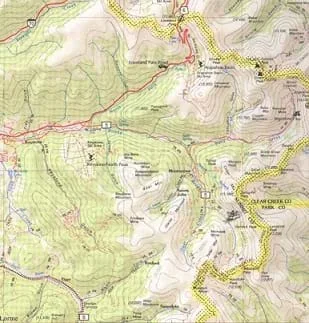 Students explore the world of mapsCopyright Map courtesy of DeLorme 2002 (www.delorme.com) Topo USA
Maps are designed to allow people to travel to a new location without a guide to show the way. They tell us information about areas to which we may or may not have ever been. There are many types of maps available for both recreational and professional use. A navigator uses a nautical map, while an engineer might use a surveyor's map. Maps are created by cartographers, and they can be very specific or very general, depending on their intended use. The focus of this lesson is on how to read and use topographical maps. Students will also learn to identify the common features of a map. Through the associated activities, students will learn how to use a compass to find bearing to an object on a map and in the classroom.
Maps are an important tool for all types of engineers. A civil engineer carefully examines topographic maps to decide the best location to construct a power plant for the safety of surrounding populations. NASA engineers sending a robot to a planet's surface must pick a suitable landing spot (a flat area rather than a steep canyon). For electrical engineers, circuit diagrams serve as maps to communicate with others how to build the circuit. Interpreting maps is an essential skill for all types of engineers.
After this lesson, students should be able to:
- Understand the major features of maps and compasses
- Understand how scaling works
- Understand how interpreting maps is an essential skill for all types of engineering
- 8.4.2 Direct and indirect measurement can be used to describe and make comparisons.
Grade 8
Do you agree with this alignment? - HS.1.2.a.i.2 Choose and interpret the scale and the origin in graphs and data displays.
Grades 9-12
Do you agree with this alignment?
- CCSS.Math.Content.6.RP.A.1 Understand the concept of a ratio and use ratio language to describe a ratio relationship between two quantities.
Grade 6
Do you agree with this alignment? - CCSS.Math.Content.7.G.A.1 Solve problems involving scale drawings of geometric figures, including computing actual lengths and areas from a scale drawing and reproducing a scale drawing at a different scale.
Grade 7
Do you agree with this alignment?
- STEL-3G Explain how knowledge gained from other content areas affects the development of technological products and systems.
Grades 6-8
Do you agree with this alignment?
Maps for Different People
Maps come in a variety of forms: city maps, road maps, nautical maps, topographical maps, and many others. The features of a map are dependent upon the intended use. For example, a state map shows cities, major roads, national parks, county lines, etc. A city map shows streets and major landmarks for that city, like hospitals and parks. To be able to use a map to find your way, you must first determine where your current location is on the map. You typically do this by comparing the landmarks you see to those shown on the map. You might use a physical landmark like a park or the intersection of two roads. In the U.S., most streets are marked with signs, so finding a street intersection is not too difficult. In some cities around the world, street signs are not very common, so matching up where you are with a point on the map can be tough. In this case, you might compare the shapes of roads (curves, circles, etc.), or count the number of roads from another physical landmark, like a river or railroad.
Scale, Legends and Orientation
All maps have a scale and a legend. The scale of a map — which is based on the physical size of the map — shows the actual distance between different locations. People can determine this by relating the distance between points on a map (usually an inch) to the actual physical distance between those points on Earth. For example, a scale that might be found on a state map equates one inch to 50 miles.
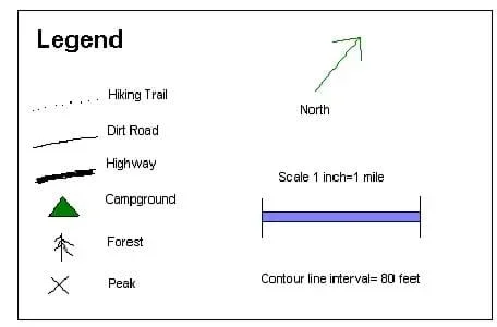 Figure 1. A sample map legend.Copyright M. Lundberg, University of Colorado at Boulder, 2003.
The scale is noted in the map's legend, a set of definitions and background information about what is shown on the map. The legend tells us the name of the area that the map is showing (like which city), the scale (how big the area is), and a list of landmark types and their corresponding symbols (see Figure 1). Common symbols are an X, for peaks, and a Δ (triangle), which denotes a campground. Also shown on the map is its orientation. The orientation tells which direction is north. Most maps (state, road, topographical) show north as pointing straight up. So when we look at a map with the majority of words horizontally readable from left to right, north is always pointing up. City maps are usually oriented so that the layout of the city makes the most sense. If all the roads in a city run northwest to southeast, having a map oriented with north up would make the map look crooked. So, for convenience, a city map for this area would be oriented with northwest toward the top of the page. The orientation arrow still points to north, but it is not pointing up.
Topographical Maps
One frequently-used type of map is called the topographical (or, topo) map. The most important feature of a topo map is that it shows the elevation (or height) of the land using contour lines (see Figure 2). Contour lines connect points around a given area (think of a mountain) that are at the same elevation. Each contour line represents a specific elevation, and on a given map, there is a fixed elevation difference between contour lines. In Figure 3, the innermost circle on the left is marked 40. That means that every point on that line is at an elevation of 40 ft. A closed contour ring like this represents either a peak or a valley — you can tell which one by checking the next few contour lines. In the figure below, the next ring is marked at 30 ft. So, you can see that the 40-ft. contour line encloses a peak with an elevation of at least 40 ft. and not more than 50 ft. (If it is higher than 50 ft., there would have to be another inner ring on the left.) In this picture, you can see that there are actually two peaks — the one on the right goes up to 50 ft. As you move away from the two peaks the terrain levels out so that the 20-foot contour line actually encloses both of the peaks. You can use peaks and valleys on a topo map as landmarks to help identify where you are.
To get a better feel for what is represented by the topo map, we will look at a cross-section of the area. Assume we are interested in going from point A to point B on the map in Figure 2. The cross-section of this path is shown below the contour map, and is known as an elevation plot. The cross-section shows the height of the terrain along the path. You can see from this diagram that traveling directly along the line from A to B would involve going straight up and down the two peaks!
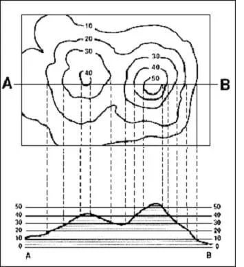 Figure 2. Contour lines on a topographical map.Copyright http://usgs.gov/
Topo maps are tricky to read at first, but, with a little practice and some helpful tips, reading and understanding them becomes much easier. An experienced map reader can easily spot hills and peaks on the topo map and know, roughly, how difficult or easy it would be walk the terrain.
The first thing to notice is the distance between the contour lines. If the lines are far apart, the slope (or elevation change) is small and vice-versa: if the contour lines are close together the slope is greater. The Grand Canyon, known for its high canyon walls, would have contour lines that are very close together. A state like Nebraska, known for its flatness, would barely even have contour lines. This is illustrated in Figure 2. On the left side, the 10-ft. contour line is far away from the 20-ft. contour line. Looking at the same point on the elevation plot, you can see that the slope is pretty shallow. It would be easy to walk up this slope. But, looking at the right hill, the distance between the 40-ft. contour line and the 50-ft. contour line is small. The corresponding elevation plot shows a steep slope. Walking that part of the line would be much more difficult.
Scale, Orientation and Grids
Topo maps use a set of standard scales. This number is a ratio of the distance on the map related to the actual distance. For example, if the ratio were 1:4, an inch on the map would represent 4 inches of actual distance. Of course, this scale would be far too small to be useful, so actual scales are much larger. Below are the three most common scales for topo maps.
- 1:250,000 – These maps cover a large area such as a county or small state. Using this scale, an inch on the map is approximately an actual distance of 4 miles. These maps are useful for long-range exploration.
- 1:62,500 – These maps cover a moderately sized area like a national park. An inch on the map equates to roughly one mile of actual distance.
- 1:24,000 – These maps cover a small sized area. An inch on this map equates to 2,000 ft. This unit of measurement is useful for surveying, so these maps are generally made for this purpose.
The orientation of topographical maps is always north. In other words, north is always pointing up. Topo maps are specifically designed to be used easily with a compass. Students can practice using a compass with the associated activity Where Is Your Teacher?
Topo maps also have a grid. This grid separates the map into many small square sections. This makes it easier to read the map, to use a compass, and to discuss your location with other people. It is easier to say "I am in grid A5" than it is to say "I am at N40'0.1 by W103'45.6." This grid is made by drawing lines some distance apart that run north-south and then drawing lines that run east-west that same distance apart. This results in a square pattern on the map. These lines are also useful when using a compass. Refer to the associated activity The Trouble with Topos for students to learn how to read topological features on a map.
Introduction to the Orienteering Compass
An orienteering compass is specifically made for wilderness travel. It is easy to use and has a number of features that are compatible with topographical maps. The orienteering compass has many special features (see Figure 3).
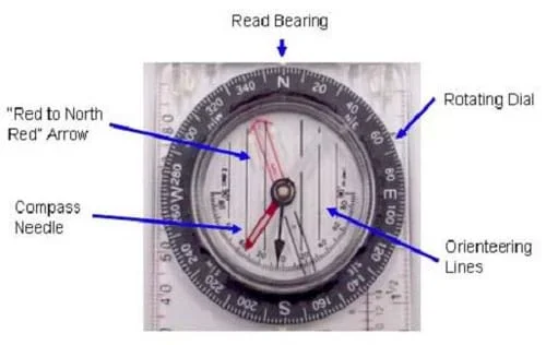 Figure 3. An orienteering compass.Copyright M. Lippis, University of Colorado, Boulder, 2003.
- "Red to North Red" Arrow – this arrow moves with the rotating dial to align with the compass needle. Notice the luminous lines around the top: these help to see in the dark.
- Compass Needle – this needle points in the direction of the magnetic field. The red end points to magnetic north. Notice the luminous line in the middle: this helps to see the needle in the dark.
- Read Bearing – after aligning the compass needle within the "red to north red" arrow, the bearing is read here.
- Rotating Dial – rotating this dial allows you to align the red-to-north-red arrow with the compass needle. This dial has the direction on it.
- Orienteering Lines – these lines are used with topographical maps. Topographical maps have grids on them that allow you to align the map and the compass.
Taking a Bearing Using a Compass
The most basic skill in using a compass is taking a bearing. This tells you what direction (or bearing) you are facing or what direction someplace is, like a mountain, a tree or a building, from where you currently are located. This skill is essential to any activity for which one might use a compass. Luckily, taking a bearing is very easy. Using a compass, follow the steps below to take a bearing:
- Face some object, like a building or a tree (about 20-30 ft. away) that you wish to know its direction (from you).
- Place your compass (open it first, if it has a cover) against your stomach or belt, perpendicular to your body and facing straight ahead of you. The face of the compass should be able to be read if you look down onto the compass.
- Rotate the rotating dial until the red end of the compass needle lies between the "red to north red" arrow.
- Read the bearing (direction) on the compass. Looking at the compass, this should be the number on the dial that is facing the front of the compass. Usually the compass has a little tick mark or might even say "READ BEARING."
Following a Bearing Using a Compass
If you are walking someplace, such as back to your campsite, and camp is west 270 degrees, you need to know how to walk in that direction. This is called following a bearing.
- Rotate the rotating dial until the red end of the compass needle lies between the "red to north red" arrow.
- Now, walk in the direction that you need to go (in our case, west), being sure to always keep your compass needle between the "red to north red" arrow (i.e., if you need to go west back to camp, look at the compass to see what direction west is — then just walk in that direction).
- It is often easy to start veering off from the direction you really want to head. An easy solution for this is to place the compass against your stomach or belt so that you can always look down and make sure you are heading in the right direction.
Measuring a Bearing on a Map Using a Compass
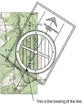 Figure 4. Measuring a bearingCopyright M. Lippis, University of Colorado, Boulder, 2003.
If you are planning a trip using a topo map, you can use your compass to find the bearing that you need to follow. First draw a line on the map from the starting point to the next waypoint. Place the compass on the topo map with its center on your starting point and with the N on the rotating dial pointing up, parallel to the vertical lines on the map (see Figure 4). The bearing you need to follow is shown by the corresponding number on the rotating dial at the point where it intersects the line that you drew. In Figure 4, we know that S (or south) is at 180 degrees, and that the bearing we need to follow is 210 degrees.
Notice that if you were starting at the other end of the line, the bearing that you would measure is 180 degrees (the other side of the compass circle) from the first bearing we took. In this example, starting at Fairview (on the map in Figure 4), we would measure a bearing to follow at 30 degrees.
Note: When we use the compass to measure bearings on the map, we are only really using the rotating dial. In the example, you can see that the compass needle is not lined up with north. You can ignore this, or if it makes things easier, you can reorient the map so that the top of the map really is in the north direction.
Ask your students how they might travel to somewhere they have never been to before. If they are going on a family vacation to the beach, how do their parents know how to get there? (Possible answer: Look at a map.) Why are they not able to use landmark navigation (identifying known landmarks to determine your location) like at home? (Possible answer: Because you do not know the relative location of landmarks if you have never been there before.)
Maps provide an image or picture of an area with both natural and man-made landmarks. By comparing what you see around you to what is on the map, you can figure out where you are and how to get to where you want to be. But how are maps useful? What do they tell us? (Possible answers: landmarks, recreational areas and roads to travel to get to different destinations.)
What if you were not traveling to another city but taking a trip in the wilderness? What kind of information do you think that you would need to know? (Possible answers: locations and names of trails, rivers, and mountains.) What if there was a mountain right in the middle of where you wanted to go? Most of us would think to go around the mountain instead of up and over it. How is a map helpful? A map might only show an "X" to indicate the peak (top) of a mountain, but the mountain is large and extends far beyond the actual peak. What would be really helpful would be a map that also tells us how high the mountain is. With such a map, you could determine how big the mountain really is. Luckily, there is a map made just for such purposes: it is called a topographical map.
Ask the students if they have ever wanted to go somewhere that they have never been. How could they find their way there? (Possible answer: Use a map.) Are all maps the same size? (Answer: No) What tells a user the size of a map and how much area it shows? (Answer: The scale.) Where on the map do we find the scale and other important information about the map? (Answer: In the legend.) Ask the students that if they were planning a trip outside, how could a topographical map help them? (Possible answers: It shows the elevation and other interesting features, such as mountains, rivers and vegetation.) Ask the students how they could find the direction of an object like a tree? (Possible answer: Take a bearing of the tree using a compass.) But what if we knew what direction the tree was in, but we could not see it. How would we get there? (Possible answer: Use the compass to follow a bearing to the tree.)
- scale
- The ratio of a distance on a map versus the actual distance is represents.
- legend
- The feature of the map that gives important information about the map. Includes the scale, location and landmark symbols used by the map.
- orientation
- Shows which direction is North on the map.
- elevation
- The height of a location. At sea level, this would be 0 ft.
- topographical map
- A map that includes elevation information. Usually used for outdoor travel.
- contour lines
- Lines on a topographical map that show the elevation along that line.
- compass
- An instrument that uses a magnetized metal bar to indicate the direction of the Earth's magnetic poles.
- bearing
- The direction, in degrees, that an object is at, like a mountain or tree.
Pre-Lesson Assessment
Discussion Question: Solicit, integrate and summarize student responses.
- Ask your students how they might travel to somewhere they have never been to before. If they are going on a family vacation to the beach, how do their parents know how to get there? (Possible answer: Look at a map.) Why are they not able to use landmark navigation (identifying known landmarks to determine your location) like at home? (Possible answer: Because you do not know the relative location of landmarks if you have never been there before.)
Lesson Summary Assessment
Inside/Outside Circle: Have the students stand in two large circles such that each student has a partner. Three people may work together if necessary. The outside circle faces in and the inside circle faces out. Ask the students the questions from the Lesson Closure section. Both members of each pair think about the question and discuss their answers. If they cannot agree on an answer, they may consult with another pair. Call for responses from the inside or outside circle or the class as a whole.
Homework
Map Making: Have students use the Internet to map out a set of directions using one of the many free online mapping tools (such as, www.mapquest.com or www.googlemaps.com).
Have students draw a map of their classroom. How would they draw topographic lines for a desk or chair?
Have students perform an Internet search for an interesting picture of a park, mountain or outdoor site. Have them draw a topographic map of their site in color.
Have students practice taking a bearing on a map. For example, the blank map in the "Getting to the Point" lesson can be used to take a bearing from Little Echo Lake to Heart Lake. (Answer: 310NW) Have students practice drawing a line between the locations first.
USGS site. http://erg.usgs.gov/isb/pubs/factsheets/fs03501.html
- Plot Your Course - Navigation
Contributors
Matt Lippis; Penny Axelrad; Malinda Schaefer Zarske; Janet Yowell
Supporting Program
Integrated Teaching and Learning Program, College of Engineering, University of Colorado Boulder
Acknowledgements
The contents of this digital library curriculum were developed under a grant from the Satellite Division of the Institute of Navigation (www.ion.org) and National Science Foundation GK-12 grant no. 0338326. However, these contents do not necessarily represent the policies of the NSF and you should not assume endorsement by the federal government.
Copyright
2004 by Regents of the University of Colorado.