
Nautical Navigation
In this activity, students explore the importance of charts to navigation on bodies of water. Using one worksheet, students learn to read the major map features found on a real nautical chart. Using another worksheet, students draw their own nautical chart using the symbols and identifying information learned.
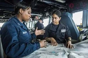 Students explore nautical navigationCopyright Flickr https://www.flickr.com/photos/usnavy/17243707942
Engineers continually adapt their problem-solving skills to different situations. The engineering design process is a series of steps that engineering teams use to guide them as they solve problems. First, engineers gather information and conduct research to understand the needs of the problem to be solved. Then they brainstorm many imaginative possible solutions. They select the most promising idea and make a final design. They create and test many prototypes, making improvements until the end product or solution is the best it can be. This process is used in all engineering disciplines.
After this activity, students should be able to:
- Understand fundamental differences between navigation on land vs. navigation on water.
- Identify major features and read the essential symbols and information provided on nautical charts.
- Describe how using the information provided on nautical charts can help find your location and navigate on water.
- 7.4.1.a.i Solve problems involving scale drawings of geometric figures, including computing actual lengths and areas from a scale drawing and reproducing a scale drawing at a different scale.
Grade 7
Do you agree with this alignment?
- Describe methods and equipment used to explore the solar system and beyond
Grade 8
Do you agree with this alignment?
- CCSS.Math.Content.7.G.A.1 Solve problems involving scale drawings of geometric figures, including computing actual lengths and areas from a scale drawing and reproducing a scale drawing at a different scale.
Grade 7
Do you agree with this alignment?
- Transporting people and goods involves a combination of individuals and vehicles.
Grades 6-8
Do you agree with this alignment?
Each student needs:
- 1 copy of each of the two activity worksheets
- Colored pencils, markers or crayons (red, green, purple)
If you were floating on a boat on the ocean how would you find your way back home? Ask the students to suggest ways that a person could find his/her way if s/he is traveling by boat?
We are all familiar with maps that help us find our way as we walk, bike or drive in our own town or in a new city. Ask the students if they've ever seen a map for traveling on water. How would that map be different than what you would use if you were traveling by car? (Possible answers: No roads, sidewalks, street signs are available on the water. You would want to know the water depth, the location of bridges, lighthouses and harbors, the location of underwater obstacles [rocks, shipwrecks], etc.)
Maps that are used by people who are navigating on oceans, lakes, rivers (any body of water) contain helpful locator information, just like maps used on land. Maps used for navigating on water are called navigational charts.
Today we're going to look at a real nautical chart and learn to read its symbols and information. Then, we're going to draw our own navigational charts, using the same types of symbols and identifying information.
Background
Sea Navigation
We have all traveled by car or on foot; it is easy to understand. But, what about traveling by sea? The sea is open and barren with no distinctive features. Dead reckoning is a very important skill for knowing where you are when traveling by sea. Because environmental conditions, such as sea currents or wind, can cause errors when using dead reckoning, it is important to look for landmarks. But, there are no natural landmarks on the sea. Luckily, people have made landmarks for us.
Aids in Sea Navigation
What other types of information would be helpful to know? What if you are traveling in a bay that is very shallow? You would want to know how deep the water is so that you do not run aground and damage your vessel. There are few natural landmarks that can be used. For this reason, people have made landmarks to use for navigating on water. Examples include:
- Buoys: These floats with a bell or light are moored (anchored) in water. They are used as a landmark, a warning of danger, or a marker of a bay or channel.
- Lighthouse: A tower with a bright, rotating light, located on or near shore to inform a sailor that land is nearby. Lighthouses are especially useful at night or in bad weather, when one's sight is limited. For example, a sailor could easily run into land if s/he could only see a distance of 20 feet.
- Beacons: A generic term for some sort of sea landmark, such as a buoy or lighthouse.
- Old shipwrecks: Ships do sink, and you definitely want to avoid them so that you do not sink your vessel also.
Nautical Charts
Land maps are not very useful when you are on the sea. Special maps designed for traveling by sea are called nautical charts. Some of their features are:
- Depth: Nautical maps show depths under the water surface, just like topographical maps show elevation on the ground. Ship captains use these maps to avoid shallow areas or shipwrecks that could damage their ships.
- Shoreline: Sailors like to know where land is located.
- Landmarks: Such as shipwrecks and beacons.
- Magnetic declination: Sailors must know the difference between true north and magnetic north, so that they can navigate properly.
- Routes: Nautical maps show shipping lanes, and common and safe routes for sea vessels. Sailors use these lanes just like drivers use streets. Shipping lanes avoid shallow areas that can damage (or even sink) ships.
- Currents: Nautical maps show the general direction in which the current flows at various locations.
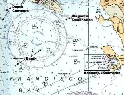 Figure 1. A section of the nautical chart for the San Francisco Bay in California.Copyright National Oceanic and Atmospheric Association and Federal Aviation Administration, 2003.
Figure 1 depicts a section of a nautical chart for the San Francisco Bay in California. Note the many common features of the map (items with arrows pointing towards them) such as water depths, contour lines, the magnetic declination, and landmarks and beacons.
Beacon Nomenclature
There are many types of beacons; some flash regularly, and some flash in a pattern, and some make sounds. Knowing the characteristics of a beacon helps a navigator identify the beacon, and therefore determine his/her location. On nautical charts, specific nomenclature (or naming system) is used to provide navigators with information to describe the type of beacon.
For example, the first beacon in the box in Figure 1 is marked: Fl R 4s 14ft 4M "4." The first descriptor denotes the type of beacon. In this case, F1 is a beacon with a flashing light, which helps navigators identify the beacon in inclement weather. The next descriptor indicates the color: R for red. The next descriptor shows the period of the flashes; this beacon flashes every 4 seconds. The next descriptor is the height of the beacon, 14 feet. After that is the range that the beacon can be seen from: 4 miles. And finally, the last descriptor is a beacon identifier, number 4.
As another example, in Figure 1 there is also a beacon marked: Q 12ft 6M. The Q stands for quick. This is a light that flashes about 60 times per minute, or once per second. Just like the previous example, the 12 ft. tells us that the beacon is 12 ft. high, and the 6M tells us that the beacon can be seen from 6 miles away.
Before the Activity
- Gather materials.
- Print out each of the two worksheets for each student.
With the Students
Nautical Charts Worksheet
- Talk about nautical charts. Ask students if they have ever seen a map for boaters. Ask students what would make a map for sailors different from one for drivers (e.g., need to know depth, different types of obstacles, need to know sea currents). Clarify that maps used at sea are called nautical charts, not maps.
- Give each student a copy of the Nautical Charts Worksheet. Ask the students to find the deepest and shallowest points on the chart. The deepest is 20 meters, on the far left of the chart. The shallowest is 2 meters on the far right.
- Describe a beacon and its purpose. Beacons, such as buoys or lighthouses, serve as the street signs of the sea. If you are traveling towards land, the green beacons are markers for the left side of the road, and the red beacons are markers for the right side. Together, these beacons form a "road" in the sea. Ask the student to look for beacons on the chart and count (writing on the worksheet) how many they find.
- Have the students find the beacon marked F1 G 2s 14ft "1" on the chart. Describe what each part of this beacon notation stands for (described on the worksheet, too) so they understand how beacons are described on nautical charts.
- Have the students locate the beacon marked Fl R 2s 14 ft "2" and answer the questions listed under Question 3 on the worksheet.
- Have the students locate all the red and green beacons on the chart, writing a red or green "X" on each of them, and making a count to complete Question 4 on the worksheet.
- At this point, the students should start to see a boat path emerging on the chart; it is noted on the chart in dotted lines. Have them color in this travel route on their chart.
- Ask the students why sailors would want to know if there was a big stake or a shipwreck in the water in their path. Knowing the location of an obstacle helps a sailor avoid it and, if it can be seen, serves as a landmark to help the sailor know his/her exact location. Some water obstacles are submerged (located below the water so cannot be seen). A pile is a heavy beam of wood, concrete or steel that has been driven into the earth as a foundation for a support or structure. Have them identify the obstacles on the chart, which are marked with little open circles.
- Ask them to look at the chart to determine how shallow the water becomes as they travel into the harbor. This is labeled on the chart next to the path lines as 6 ft.
Make Your Own Nautical Chart Worksheet
- In the Make Your Own Nautical Chart Worksheet, the students draw their own nautical charts. Give each student a new worksheet.
- Have the students name their chart.
- Have them draw an island somewhere on the chart, and other land features, too.
- Have students include an appropriate scale.
- Have the students draw water depth markers. These are just numbers (in meters) that indicate the depth of the sea at that point. Caution them not to make it too shallow (low depths such as 1 m or 3 m) because it would be too shallow for boats to travel through.
- Describe a harbor and a marina. A harbor is a sheltered part of a bay of water that is deep enough for ships to dock. Boats are moored (anchored, docked, parked) at a marina in a harbor. Have the students draw two harbors on their charts. On the worksheet, an example illustration shows how a pier or marina with docked boats might look on a chart.
- Have them draw in some obstacles, using a small open circle to mark the location, and a brief identifier label next to the circle, such as "stake," "large rocks" or "shipwreck."
- Ask the students to identify the path to get to the harbor. Tell them that their boat is 4 meters deep, so they must define a route with at least 5 m of water depth along the path.
- Have the student use their green and red pencils to place beacons on the chart at locations to guide a sailor along the harbor path. Green beacons are on the left side of the boat, traveling inward towards shore, and red beacons are on the right.
- Have students "show and tell" the rest of the class their nautical charts, explaining their work to the class.
Pre-Activity Assessment
Discussion Questions: Ask students and discuss as a class:
- Have you ever seen a map for boaters? How would a map for sailors on the water be different from one for drivers on land? (Possible answers: It would provide information such as water depth, obstacles in the water, sea currents, etc.)
Activity Embedded Assessment
Worksheets: Have the students complete the activity worksheets; review their progress and answers to gauge their mastery of the subject.
Post-Activity Assessment
Show and Tell: Have the students "show and tell" to the rest of the class the nautical charts they created, explaining their work to the other students.
- For upper grades, on the Make Your Own Nautical Chart Worksheet, have the students make detailed labels on the beacons. For example, instead of just red or green have them create a description such as "Fl R 4s 16ft "1."
Federal Aviation Administration:http://www.faa.gov/
Federal Aviation Administration Kid's Corner: http://www.faa.gov/education/student_resources/kids_corner/
For information and photographs of aids to navigation, see the Tideland Signal Corporation manufacturer web site at: http://www.tidelandsignal.com/
- Plot Your Course - Navigation
- Where Is Here?
- How to be a Great Navigator!
- Navigating by the Numbers
- Accuracy, Precision and Errors in Navigation: Getting It Right!
- Topo Map Mania!
- Getting to the Point
- Navigational Techniques by Land, Sea, Air and Space
- Nautical Navigation
- Navigating at the Speed of Satellites
- GPS on the Move
- Not So Lost in Space
Contributors
Matt Lippis; Penny Axelrad; Malinda Schaefer Zarske; Denise Carlson; Janet Yowell
Supporting Program
Integrated Teaching and Learning Program, College of Engineering, University of Colorado Boulder
Acknowledgements
The contents of this digital library curriculum were developed under a grant from the Satellite Division of the Institute of Navigation (www.ion.org) and National Science Foundation GK-12 grant no. 0338326.
Copyright
2004 by Regents of the University of Colorado.