
Navigational Techniques by Land, Sea, Air and Space
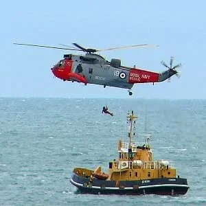 Students explore the different modes of navigation that include on land, water, air and in space.Copyright Wikimedia Commons https://commons.wikimedia.org/wiki/File:Air-sea-rescue-falmouth.jpg
Students learn that navigational techniques change when people travel to different places — land, sea, air and space. For example, an explorer traveling by land uses different navigation methods and tools than a sailor or an astronaut.
Engineers adapt their fundamental science and math skills to different situations. Understanding the science of natural phenomena enables engineers to design and build appropriate structures and systems. By combining their expertise in inventing measurement and data gathering tools with their ability to analyze and learn from past failures, engineers continually improve designs and systems for the benefit of people. This process of gathering and analyzing data to better understand problems and formulate solutions is used in all engineering disciplines.
After this activity, students should be able to:
- Understand fundamental differences between navigation on land, water, air and in space.
- Identify major features and read the fundamental symbols and information provided on land maps, nautical charts and aeronautical charts.
- Explain the concept of dead reckoning (relationship between speed, time, distance and direction) as it applies to navigation estimation.
- Understand beacon nomenclature, symbols and information as found on nautical charts.
- 8.4.2 Direct and indirect measurement can be used to describe and make comparisons.
Grade 8
Do you agree with this alignment? - 7.1.2.c Solve real-world and mathematical problems involving the four operations with rational numbers.
Grade 7
Do you agree with this alignment?
- Describe methods and equipment used to explore the solar system and beyond
Grade 8
Do you agree with this alignment?
- CCSS.Math.Content.7.G.A.1 Solve problems involving scale drawings of geometric figures, including computing actual lengths and areas from a scale drawing and reproducing a scale drawing at a different scale.
Grade 7
Do you agree with this alignment?
- STEL-3G Explain how knowledge gained from other content areas affects the development of technological products and systems.
Grades 6-8
Do you agree with this alignment?
Navigating in Different Environments
Most of us know about navigating on land; we do it everyday when we are walking home or driving to the store. Navigation is used in all sorts of environments, and it is, therefore, always important to know your location. Navigating on land is very different than in the water, in the air, or in space because all each type of navigating requires different types of information. For example, a topographical map would not help you navigate on the sea. There are different navigation needs depending on whether you are traveling on land, sea, air or in space.
Dead Reckoning
Even though traveling in different environments requires different types of information, like maps, some things are common to all navigation. All navigation requires use of the concept of dead reckoning. Refer to Lesson 2 of the Navigation unit for more detailed information on dead reckoning.
Dead reckoning is the process of navigation by advancing a known position using course, speed, time and distance to be traveled. In other words, it is the process of figuring out where you will be at a certain time in the future if you hold steady the speed, time and course you plan to travel. Prior to the development of celestial navigation, sailors navigated by deduced (or dead) reckoning. Columbus and most other sailors of his era used this method. In dead reckoning, the navigator finds his position by estimating the course and distance he has sailed from some known point. Starting from a known point, such as a port or harbor, the navigator measures out his course and distance from that point on a chart, pricking the chart with a pin to mark the new position.
Speed, Time and Direction
How did they know their speed? In Columbus' day, the ship's speed was measured by throwing a log over the front side of the ship. There were two marks on the ship's rail that were a measured distance apart. When the log passed the forward mark, the pilot would start a quick chant; when the log passed the aft (last) mark, the pilot would stop chanting. (The exact words to such a chant are part of a lost history of navigation.) The pilot would then note how much of the chant he recited, which would then enable him to determine the speed of the boat based on the distance traveled. This method would not work when the ship was moving very slowly, since the chant would be over before the log actually reached the aft mark. This approach may be expressed as a simple equation:
Speed x Time = Distance
This makes sense when you look at the units:
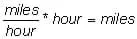
In the equation, the hours cancel each other out, resulting in a distance in miles.
Along with the speed and distance, early sailors needed to know the direction of travel. This was accomplished using a compass. Once they knew their distance and direction, they could determine their current location based on their previous location.
So, what are the items we need to know to navigate using the dead reckoning approach?
- Speed: We have to know how fast we are traveling.
- Time: We need to know for how long we have been traveling.
- Direction: We certainly need to know in which direction we are going.
- Our previous location: It is good to know our speed, time and direction, but it is not enough unless we also know our exact last location.
We need to know all these variables to navigate.
Land Navigation
In previous lessons, we learned how to navigate on land. What types of information do you need to navigate on land?
Traveling by Car
- Road maps: The first thing you do when you plan a road trip is get out a road map. It provides you with information on the choice of roads, the distance to a certain destination, and sometimes even suggests the quickest route to get there.
- Street signs: A must for traveling in any city, they help you find your location on a city street map.
- Mileage signs: These signs indicate the distance to the next city or town, and are very helpful to find your location on a road map.
Traveling by Foot
- Topographical maps: These maps provide detailed information about the land surface.
- Compass: This device helps you determine your direction. Used with a topographical map, you can triangulate to determine your exact position.
Sea Navigation
We have all traveled by car or on foot; it is easy to understand. But, what about traveling by sea? The sea is open and barren with no distinctive features. Dead reckoning is a very important skill for knowing where you are when traveling by sea. Because environmental conditions, such as sea currents or wind, can cause errors when using dead reckoning, it is important to look for landmarks. But, there are no natural landmarks on the sea. Luckily, people have made landmarks for us.
Aids in Sea Navigation
What other types of information would be helpful to know? What if you are traveling in a bay that is very shallow? You would want to know how deep the water is so that you do not run aground and damage your vessel. There are few natural landmarks that can be used. For this reason, people have made landmarks to use for navigating on water. Examples include:
- Buoys: These floats with a bell or light are moored (anchored) in water. They are used as a landmark, a warning of danger, or a marker of a bay or channel.
- Lighthouse: A tower with a bright, rotating light, located on or near shore to inform a sailor that land is nearby. Lighthouses are especially useful at night or in bad weather, when one's sight is limited. For example, a sailor could easily run into land if s/he could only see a distance of 20 feet.
- Beacons: A generic term for some sort of sea landmark, such as a buoy or lighthouse.
- Old shipwrecks: Ships do sink, and you definitely want to avoid them so that you do not sink your vessel also.
Nautical Charts
Land maps are not very useful when you are on the sea. Special maps designed for traveling by sea are called nautical charts. Some of their features are:
- Depth: Nautical maps show depths under the water surface, just like topographical maps show elevation on the ground. Ship captains use these maps to avoid shallow areas or shipwrecks that could damage their ships.
- Shoreline: Sailors like to know where land is located.
- Landmarks: Such as shipwrecks and beacons.
- Magnetic declination: Sailors must know the difference between true north and magnetic north, so that they can navigate properly.
- Routes: Nautical maps show shipping lanes, and common and safe routes for sea vessels. Sailors use these lanes just like drivers use streets. Shipping lanes avoid shallow areas that can damage (or even sink) ships.
- Currents: Nautical maps show the general direction in which the current flows at various locations.
Figure 1 depicts a section of a nautical chart for the San Francisco Bay in California. Note the many common features of the map (items with arrows pointing towards them) such as water depths, contour lines, the magnetic declination, and landmarks and beacons.
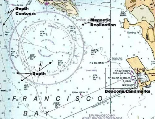 Figure 1. A section of a nautical chart for the San Francisco Bay in California.Copyright National Oceanic and Atmospheric Association and Federal Aviation Administration, 2003.
Beacon Nomenclature
There are many types of beacons; some flash regularly, and some flash in a pattern, and some make sounds. Knowing the characteristics of a beacon helps a navigator identify the beacon, and therefore determine his/her location. On nautical charts, specific nomenclature (or naming system) is used to provide navigators with information to describe the type of beacon.
For example, the first beacon in the box in Figure 1 is marked: Fl R 4s 14ft 4M "4." The first descriptor denotes the type of beacon. In this case, F1 is a beacon with a flashing light, which helps navigators identify the beacon in inclement weather. The next descriptor indicates the color: R for red. The next descriptor shows the period of the flashes; this beacon flashes every 4 seconds. The next descriptor is the height of the beacon, 14 feet. After that is the range that the beacon can be seen from: 4 miles. And finally, the last descriptor is a beacon identifier, number 4.
As another example, in Figure 1 there is also a beacon marked: Q 12ft 6M. The Q stands for quick. This is a light that flashes about 60 times per minute, or once per second. Just like the previous example, the 12 ft. tells us that the beacon is 12 ft. high, and the 6M tells us that the beacon can be seen from 6 miles away.
Navigation in the Air
Pilots, like sea captains, must be able to navigate by dead reckoning. Sadly, this is not easy to do. What landmarks would you look for if you were a pilot? A street sign? A field? When airplanes were first invented, there were no good landmarks for pilots to use. In fact, many pilots would fly really low and slow, hoping to read the road signs to figure out which town they were near.
What kind of landmarks would be useful for pilots? Items such as railroad tracks, buildings, ranches, water or oil tanks, towns, lakes, rivers and highways can usually be seen from the sky. Recreational pilots in small aircraft find landmarks like these to be quite useful in determining their locations. But, a commercial airline pilot would not use these types of landmarks because commercial jetliners fly at about 35,000 ft., much too high to make out most of these landmarks. Can you imagine trying to identify landmarks that are seven miles away?
Aeronautical Charts
Pilots use aeronautical charts just like sailors use nautical charts. Anything that can help the pilot figure out where he is and help him land will be noted on the aeronautical chart. Aeronautical chart features include:
- Elevation: Pilots must know the elevation of landforms in an area. For example, if there is a mountain in your flight path, you would want to know how high it is so that you can fly above it.
- Airports: An aeronautical chart indicates the presence of airport elevation markers, runways (the road that you land on), flashing lights that show the pilot where to land, buildings and tanks. Locating these items helps pilots land safely.
- Landmarks: Such as a river, golf course or bridge.
Scale of Aeronautical Charts
Traveling by foot or boat is slow compared to airplane travel. Since so much distance is covered quickly, typical aeronautical map scales are 1:500,000, meaning that an inch on the chart represents about 10 miles.
On the aeronautical chart in Figure 2 we can see a number of distinct features. The maximum elevation for any landform on the chart is 4,800 ft.; this is the highest point on that part of the chart, including buildings and natural features such as mountains. The chart also provides elevation contour lines. Helpful landmarks, such as ranches, a golf course and a trailer park, can be identified by pilots from the flying elevation of a recreational airplane like a twin engine Cessna. Most importantly, this map shows the two airports in the area. Notice the purple circle area and the two lines crossed within it, which are the runways. The purple outline around the whole airport shows the airport's airspace, which for safety reasons — unless a pilot is landing at that airport, he should not enter.
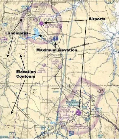 Figure 2. A section of a typical aeronautical chart.Copyright Federal Aviation Administration, 2003
Space Navigation
Navigating in space is very different from other forms of navigation. Usually, sea drift or wind drift cause travelers by sea or air to move off course. But in space, the sources of error are far smaller. Once a spacecraft is in a known orbit, it perpetually travels along that orbit.
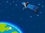 Copyright Microsoft Corporation, 1983-2001.
What Is an Orbit?
We all know that the Earth travels around the sun. This happens because the gravity of the sun is constantly pulling on the Earth. Like tying a ball to a string and swinging it around your head, the pull of the string on the ball is like the gravity of the sun pulling on a planet or satellite. Satellites travel around the Earth just like the Earth travels around the sun. The path that the satellite travels in is called an orbit. The satellite just keeps traveling along that orbit because there are no major sources of drift in space, such as wind or sea currents. Few conditions are present that would make satellites drift, such as small changes in gravity or the impact of meteorites, and the probabilities of these events are quite small. Therefore, it is not complex for knowledgeable people to predict where that spacecraft, moon or planet will be in an hour or a day. The methods used to predict the position of objects in outer space are just like dead reckoning, but with minimal drift and a constant speed.
Key characteristics that people must know when anticipating the position of objects in space include: How fast the object is moving, in what direction the object is moving and in what orbit it travels. Spacecraft send light waves down to the Earth to determine this information. By measuring properties of the light, spacecraft and satellites can calculate where they are and how fast they are going. Once their speed and location is known, computers in the spacecraft calculate in which orbit they are traveling. Once the computers determine the spacecraft's orbital path, its future path can be predicted using methods similar to dead reckoning.
With the students, brainstorm the differences between traveling in an airplane and traveling on foot. (Possible answers: You are up in the air, you are going faster.) Do the students think that using a standard city street map would help them navigate from an airplane? (Possible answer: No, because you would pass over a city in a couple minutes.) What kind of map would be useful for flying an airplane? (Possible answer: One that covers a much larger area.) Maps for pilots are called aeronautical charts, and we will take a look at them today.
Pose the same questions for traveling by sea. Does a city street map help you travel in a sailboat? (Possible answer: No, because there are no street signs on the ocean.) Street maps help you navigate by showing landmarks like street names, but there are no street signs on the ocean! What kinds of landmarks may be found when traveling on the sea? (Possible answers: Lighthouses, beacons, islands, buoys.) During the past few millennia, many nations and peoples have created landmarks that are either on land and visible from sea or floating in the water, like buoys. Lighthouses are a great example of landmarks for sailors. They are like street signs for the ocean. They have a big, bright light so sailors can easily see them day or night, in good weather or in storms. Seeing lighthouses helps sailors avoid hitting land or crashing into rocks. Nautical charts allow sailors to determine exactly where they are on a large body of water. Students can learn the major features of nautical charts by looking at a real charts and drawing their own in the associated activity Nautical Navigation.
What about traveling in space? How do astronauts have any idea about where they are? There certainly are no street signs in space. People on Earth can locate satellites by using big telescopes that look for special types of light emitted by the satellites.
Ask students if anyone has ever navigated with a map on land? What was that like? Ask the same questions for air and water. Tell students that in today's lesson we are going to be talking about the different types of maps that are used in the different environments — land, sea and air.
Could you use a nautical chart to get home from school or to go hiking in a park? (Answer: No, because we do not live on the ocean.) Why is a nautical chart not helpful in this situation? (Answer: It tells us information about the sea, not the land.) Can you name for me some different environments that would require different types of maps? (Answers Land, sea, air and space each require different types of maps to help people navigate in those environments.)
What types types of information do you need to know to travel on the sea? (Answers: Water depth, location of channels, paths, obstacles [such as shipwrecks or reefs], harbors, etc.) What type of information do you need to know if you are traveling in the air? (Answers: Elevation of landforms, location of airports, big landmarks that you can see, etc.) These needs are similar: sailors on the sea need to know how deep the water is, and pilots need to know how high the land is. Smaller scale land maps are also helpful for hikers who need to know about obstacles (cliffs) so that they can avoid them, and about landmarks so that they can find their locations. Everybody needs to be able to navigate no matter where they are — on land, sea or air. The navigational methods and maps just need to be specific to each environment.
- dead reckoning
- A method to calculate the location of a person, ship, or spacecraft based upon where it was some time ago. Knowing the speed, direction and how much time has passed since you last knew where it was, you can find out where the person, ship, or spacecraft is at any time in the future.
- nautical chart
- A map used for traveling on water.
- aeronautical chart
- A map used for traveling by airplane.
- buoy
- A float with a bell or light that is moored (anchored) in water and used as a landmark, a warning of danger, or a marker of a bay or channel.
- lighthouse
- A tower with a bright rotating light located on or near shores to tell a sailor that land is close. Lighthouses are especially useful to sailors at night or in bad weather.
- beacon
- Similar to a floating lighthouse. Beacons have lights that flash in many different patterns and colors to help sailors navigate. A sailor can find his location by looking for a specific beacon and determining which one it is.
- airspeed indicator
- An instrument on an airplane that tells how fast the plane is traveling relative to the wind.
- attitude indicator
- A graphical way to see the roll, pitch and yaw of an airplane.
- orbit
- The path that a satellite travels around the Earth.
Pre-Lesson Assessment
Brainstorming: In small groups, have students engage in open discussion. Remind students that no idea or suggestion is "silly." All ideas should be respectfully heard. Ask the students:
- What are the differences between traveling in an airplane and on foot? (Possible answers: You are up in the air, you are going faster.)
Post-Introduction Assessment
Ask the students and discuss as a class the questions below.
- Has anyone has ever navigated with a map on land? On water? In the air? What was that like? (Tell students that in today's lesson we will learn about the different maps that are used in the different environments—land, sea and air.)
Lesson Summary Assessment
Numbered Heads: Divide the class into teams of three to five. Have students on each team pick numbers (or number off) so each has a different number. Ask the students a question (give them a time frame for solving it, if desired). Use questions in the Lesson Closure section. The members of each team should work together on the question. Everyone on the team must know the answer. Call a number at random. Students with that number should raise their hands to answer the question. If not all the students with that number raise their hands, allow the teams to work a little longer.
Federal Aviation Administration: http://www.faa.gov/
Kid's Corner, Federal Aviation Administration: http://www.faa.gov/education/student_resources/kids_corner/
For information and photographs of aids to navigation, see the Tideland Signal Corporation manufacturer website at: http://www.tidelandsignal.com/
- Plot Your Course - Navigation
Contributors
Matt Lippis; Penny Axelrad; Malinda Schaefer Zarske; Denise W. Carlson
Supporting Program
Integrated Teaching and Learning Program, College of Engineering, University of Colorado Boulder
Acknowledgements
The contents of this digital library curriculum were developed under a grant from the Satellite Division of the Institute of Navigation (www.ion.org) and National Science Foundation GK-12 grant no. 0338326. However, these contents do not necessarily represent the policies of the NSF and you should not assume endorsement by the federal government.
Copyright
2004 by Regents of the University of Colorado.