
Topo Triangulation
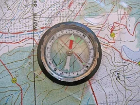 A map and compass are both needed for triangulation.Copyright http://panthertown.files.wordpress.com/2010/05/compass-on-map.jpg
In this activity, students learn how to read a topographical map and how to triangulate with just a map. True triangulation requires both a map and compass, but to simplify the activity and make it possible indoors, the compass information is given. Students practice converting a compass measurement to a protractor measurement, as well as reverse a bearing direction (i.e., if they know a tree's bearing is 100 degrees from you, they can determine what bearing they are from the tree). Students use the accompanying worksheets to take a bearing of certain landmarks and then start at those landmarks to work backwards to figure out where they are.
Triangulation technology is used for many applications. Sometimes engineers use triangulation to create auto focus in cameras. With two special rangefinder devices attached to the camera at different spots, a computer interprets the distance of an object by observing the reflected light rays. Engineers also create contour plots for more than just land features. Contours show fluid flow, temperature gradients, sound propagation and specifications important to engineers.
After this activity, students should be able to:
- Identify major features in a topographical map,
- Use triangulation to determine position
- Create a coordinate graph
- Understand how triangulation technology is used in many fields of engineering
- HS.3.1.a Summarize, represent, and interpret data on a single count or measurement variable.
Grades 9-12
Do you agree with this alignment? - 7.1.2.c Solve real-world and mathematical problems involving the four operations with rational numbers.
Grade 7
Do you agree with this alignment?
- Describe methods and equipment used to explore the solar system and beyond
Grade 8
Do you agree with this alignment?
- CCSS.Math.Content.6.NS.B.3 Fluently add, subtract, multiply, and divide multi-digit decimals using the standard algorithm for each operation.
Grade 6
Do you agree with this alignment? - CCSS.Math.Content.7.G.A.1 Solve problems involving scale drawings of geometric figures, including computing actual lengths and areas from a scale drawing and reproducing a scale drawing at a different scale.
Grade 7
Do you agree with this alignment? - CCSS.Math.Content.7.G.A.2 Draw (freehand, with ruler and protractor, and with technology) geometric shapes with given conditions. Focus on constructing triangles from three measures of angles or sides, noticing when the conditions determine a unique triangle, more than one triangle, or no triangle.
Grade 7
Do you agree with this alignment? - CCSS.Math.Content.HSG-CO.D.12 Make formal geometric constructions with a variety of tools and methods (compass and straightedge, string, reflective devices, paper folding, dynamic geometric software, etc.). Copying a segment; copying an angle; bisecting a segment; bisecting an angle; constructing perpendicular lines, including the perpendicular bisector of a line segment; and constructing a line parallel to a given line through a point not on the line.
Grades 9-12
Do you agree with this alignment?
- STEL-3G Explain how knowledge gained from other content areas affects the development of technological products and systems.
Grades 6-8
Do you agree with this alignment?
Each student should have:
- 1 copy of appropriate worksheet (either 6th Grade or 7th/8th Grade Worksheet)
- Compass to Protractor Worksheet
- Pencil
- Graph paper
- Ruler
- Protractor (students may share if necessary)
- Tape measure (students may share if necessary)
An important navigational map is the topographical (or, more typically called, topo) map. True, you may be a beginning map reader, but rest assured that even new map readers can become familiar with how to navigate using a topo map. Topo maps are tricky to read at first, but with a little practice and some helpful tips, reading them becomes much easier. Knowing how to take a bearing and how to use triangulation are important steps for reading and understanding a topo map.
The bearing of an object, such as a mountain or other landmark, depends on where the bearing is being taken. For example, if you are standing in front of the classroom facing the class, the door may be to your left, but to your classmates' right. If you are sitting beside a partner, one of you will have to look left, and the other will have to look right to see each other.
Triangulation is like finding a bearing, only it is backwards. You may be lost, but you know where the mountain is. If you have a compass, it is easy to switch the bearing directions: just look on the other side of the needle. This activity will familiarize you how with taking bearings to find specific locations.
Background
Topographical Maps
The important feature of a topo map is that it shows elevation (or height) by displaying contour lines (see Figure 1). Each contour line represents an elevation, from lowest to highest, respectively, as you move from outer to inner contour lines. By taking a cross-section of the area, the actual elevation can be visually plotted to show changes in elevation, which in Figure 1, shows a steep slope. Walking that part of the line would be much more difficult.
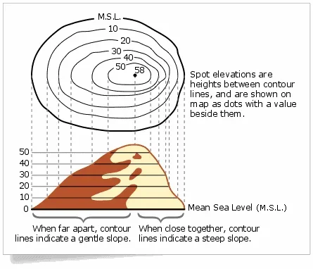 Figure 1. Contour lines on a topographical map.Copyright https://www.stockpilereports.com/contours/
Notice in Figure 1 the distance between the contour lines. If they are far apart, the slope, or elevation change, is small and vice-versa. If the contour lines are close together, the slope is steeper. The Grand Canyon, known for its high canyon walls, would have contour lines that are very closely spaced together. A state like Nebraska, known for its flat plains, would barely even have any contour lines
Another type of feature that is easy to see on a topo map is a hill or mountain peak. These are represented by rough circular shapes nested within each other that get higher as you go to the middle of the circle. If the circles are getting closer and closer together, the slope up to the peak is getting steeper. If the circles are getting farther apart the slope is leveling out.
Scale, Orientation and Grids for Topo Maps
Topo maps have a set of standard scales that they use. This number is a ratio of the distance on the map related to the actual distance. For example, if the ratio were 1:4, an inch on the map would represent 4 in. of actual distance. Of course, this scale is far too large to be useful, so real scales are much smaller. The three commonly-used scales for topo maps: 1:250,000 (cover large areas and are useful for long-range exploration); 1:62,500 (cover a moderately sized area); and 1:24,000 cover small-sized areas and are useful for surveying).
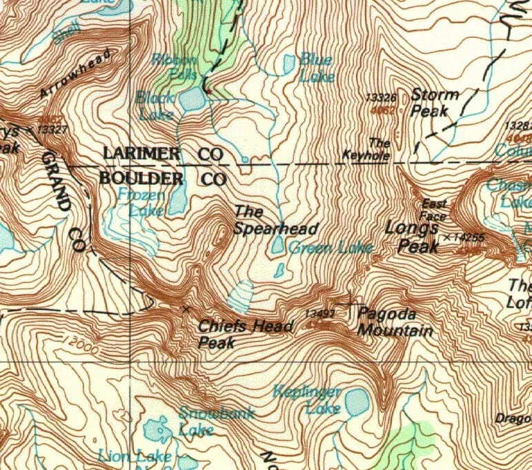 Figure 2. A topographical map.Copyright https://www.flickr.com/photos/davidwilson1949/5500966860
The orientation of topographical maps is always north. In other words, north is always pointing up. Topo maps are designed specifically to be used with compasses.
Topo maps always have a grid. This grid separates the map into many small square sections. This makes it easier to read the map, use a compass, and discuss your location. It is a lot easier to say "I am in grid A5" than it is to say "I am at N40'0.1" by W103'45.6"." This grid is made by drawing lines a specific distance apart that run north-south and then drawing lines that run east-west that same distance apart. This results in a distinct square pattern on the map. These lines are also useful when using a compass.
Before the Activity
- Complete the activity yourself before hand in order to become familiar with the process.
With the Students
Compass to Protractor Worksheet
- Give each student a piece of graph paper, a ruler, and a copy of the Compass to Protractor Worksheet.
- Have each student set up a coordinate grid.
- They should label the grid as follows: the top part of the graph as 360 and 0 degrees (this is north), the end of the right axis as 90 degrees (this is east), the bottom part of the graph as 180 degrees (this is south), and the end of the left axis as 270 degrees (this is west).
- The origin will represent the student.
- Have the students complete the worksheet.
- Have students share ideas for an easy way to switch from one bearing to another.
Individual Worksheets
6th Grade (Using 6th Grade Worksheet)
- Give each student a 6th Grade Worksheet.
- Tell them to find East Portal. Ask them that if they heard a train north of them, where could they be? (Possible answers: south, below, the train tracks.)
- Ask the students that if the dam is at a bearing of 100 degrees, what is the bearing to them from the dam? (Answer: 280 degrees, which is the opposite direction on a compass.) Note: This is 10 or 170 degrees on a protractor depending on where you start your angle measurement. Ten degrees comes from the fact that 270 degrees is west, and 90 degrees is east. This would be a horizontal line through Mammoth Creek Dam. Placing the protractor on this imaginary horizontal line and measuring "up" 10 degrees (in the west direction), will give you 280 degrees. Likewise, measuring 170 degrees starting from the east direction will produce the same direction.
- Now have the students draw a line from the Mammoth Creek Dam at 10 degrees on the protractor, which is the same as a bearing of 280 degrees.
- Ask them why this line is important. (Answer: Their location is along that line.)
- Ask the students that if Haystack Mountain is at a bearing of 241 degrees, what is the bearing to them from the mountain? (Answer: On a compass, this would be the opposite direction, so 61 degrees.) Note: This is 29 or 151 degrees on a protractor (29 degrees measuring "up" from the east and 151 measuring from the west.
- Now have them draw a line from Haystack Mountain at 29/151 degrees on the protractor, which is the same as a bearing of 61 degrees.
- Ask students if the two lines intersect. (Answer: Yes)
- What is important about the intersection of these two lines? (Answer: That it is the students' location.)
- Now that they know their location, ask them to figure out which lake is Clue #5. (Answer: Crater Lake)
7th & 8th Grade (Using 7th / 8th Grade Worksheet)
- Give each student a 7th / 8th Grade Worksheet.
- Tell them to find East Portal. Ask them that if they heard a train north of them, where could they be? (Possible answers: south, below, the train tracks.)
- Ask them to find a big body of water that has a dam. (Answer: Mammoth Creek Dam.)
- Ask the students that if the dam is at a bearing of 100 degrees, what is the bearing to them from the dam? (Answer: 280 degrees, which is the opposite direction on a compass.) Note: This is 10 or 170 degrees on a protractor depending on where you start your angle measurement. Ten degrees comes from the fact that 270 degrees is west, and 90 degrees is east. This would be a horizontal line through Mammoth Creek Dam. Placing the protractor on this imaginary horizontal line and measuring "up" 10 degrees (in the west direction), will give you 280 degrees. Likewise, measuring 170 degrees starting from the east direction will produce the same direction.
- Now have them draw a line from the Mammoth Creek Dam at 10 degrees on the protractor, which is the same as a bearing of 280 degrees.
- Ask them why this line is important. (Answer: Their location is along that line.)
- Ask them which mountain/hill they think they are located on? (Possible answers: Nebraska Hill or Haystack Mountain)
- Remind them that the top of the hill/mountain they are on is just south of them. Ask them what hill they think they are on now. (Answer: Nebraska Hill)
- Now the students know which hill they are on, they just do not know where on the hill.
- If Haystack Mountain is at a bearing of 241 degrees, what is the bearing to you from the mountain? On a compass this would be the opposite direction, or 61 degrees. This is 29 or 151 degrees on a protractor (again, 29 degrees measuring "up" from the east and 151 measuring from the west).
- Now have them draw a line from Haystack Mountain at 29/151 degrees on the protractor, which is the same as a bearing of 61 degrees.
- Ask them if the two lines intersect. (Answer: Yes)
- What is important about the intersection of these two lines? (Answer: That it is the students' location.)
- Now that they know their location, ask them to figure out which Lake is Clue #6. (Answer: Crater Lake.)
Pre-Activity Assessment
Background Worksheet: Have students use the Compass to Protractor Worksheet to practice converting compass measurement to protractor measurement.
Activity Embedded Assessment
Worksheet: Have students follow along with activity using attached, grade appropriate worksheet.
Summary Assessment
Recruit six or seven students to role play the activity in front of the class. Have students each act as one of the "clues" from the worksheet (e.g., have someone be Haystack Mountain, Mammoth Creek, etc), and have one of the students navigate from landmark to landmark. Have the rest of the class contribute suggestions.
Post-Activity Assessment
Role Play: Recruit six or seven students to role play the activity in front of the class.
- Have students each act as one of the "clues" from the worksheet (e.g., have someone be Haystack Mountain, Mammoth Creek, etc), and have one of the students navigate from landmark to landmark. Have the rest of the class contribute suggestions.
The students might get confused using protractors in place of compasses. A compass starts at North (0 degrees), while a protractor starts at west or east (0 or 180 degrees). Make sure that they know that 0 degrees on a compass is 90 degrees on a protractor.
Many students might not hike very often. Give the students an idea of how far they would be if they wandered cross-country through trees and rocks for 4 hours (about 2-3 miles).
- For 6th grade, have students complete the 6th Grade Worksheet.
- For 7th and 8th grades, have students complete the 7th/8th Grade Worksheet.
- Plot Your Course - Navigation
Contributors
Matt Lippis; Penny Axelrad; Janet Yowell; Malinda Schaefer Zarske
Supporting Program
Institute of Navigation and Integrated Teaching and Learning Program, College of Engineering, University of Colorado Boulder
Acknowledgements
The contents of this digital library curriculum were developed under a grant from the Satellite Division of the Institute of Navigation (www.ion.org) and National Science Foundation GK-12 grant no. 0338326.
Copyright
2004 by Regents of the University of Colorado.