
State Your Position
To navigate, you must know roughly where you stand relative to your designation, so you can head in the right direction. In locations where landmarks are not available to help navigate (in deserts, on seas), objects in the sky are the only reference points. While celestial objects move fairly predictably, and rough longitude is not too difficult to find, it is not a simple matter to determine latitude and precise positions. In this activity, students investigate the uses and advantages of modern GPS for navigation.
 Students examine the uses and advantages of modern GPS for navigationCopyright Microsoft Corporation 1983-2001.
Currently, the accuracy of a typical GPS receiver is about five meters, and engineers are continually improving the degree of accuracy. Engineering improvements to measurement devices and advances in mathematical analysis keep increasing accuracy over time, but some fundamental limitations still remain: cloudy weather, our knowledge of the exact positions of celestial objects at future times, and our ability to measure object positions accurately at those times.
After this activity, students should be able to:
- Explore the uses and advantages of modern GPS for navigation
- Triangulate a position from given data
- Understand how errors in data may affect results
- 8.2.3.b.vi Analyze how credit and debt impact personal financial goals.
Grade 8
Do you agree with this alignment? - HS.4.5 Objects in the real world can be modeled using geometric concepts.
Grades 9-12
Do you agree with this alignment?
- Describe methods and equipment used to explore the solar system and beyond
Grade 8
Do you agree with this alignment?
- CCSS.Math.Content.HSG-CO.D.12 Make formal geometric constructions with a variety of tools and methods (compass and straightedge, string, reflective devices, paper folding, dynamic geometric software, etc.). Copying a segment; copying an angle; bisecting a segment; bisecting an angle; constructing perpendicular lines, including the perpendicular bisector of a line segment; and constructing a line parallel to a given line through a point not on the line.
Grades 9-12
Do you agree with this alignment? - CCSS.Math.Content.HSN-Q.A.1 Use units as a way to understand problems and to guide the solution of multi-step problems; choose and interpret units consistently in formulas; choose and interpret the scale and the origin in graphs and data displays.
Grades 9-12
Do you agree with this alignment?
- Communication systems are made up of a source, encoder, transmitter, receiver, decoder, and destination.
Grades 6-8
Do you agree with this alignment?
Each group should have:
- 1 paper clip
- 1 piece of string (~ 30cm or 12 inches long)
- 1 rulers (with cm)
- 3 GPS Worksheets (one for each group member)
- 3 GPS States Maps
- Scotch tape (to tape the maps in place)
- 3 pencils (one per student)
If you were sailing to a harbor and saw a lighthouse, it would help guide you safely into that harbor. What type of navigation is this called and why is it important? (Answer: Landmark navigation, and it is important because sometimes it is the only method of navigation that is available.) A navigator's dream is a lighthouse that could be seen from anywhere in the world. It took a Cold War and a Space Race to lay the foundation, but this dream is now finally a reality. By the mid-1960s, it was possible to put our own precise points of reference in the sky via the U.S. Navy's NAVigation SATellite System or NAVSAT (also known as TRANSIT). The best part of this early system was that no human measurement of the objects was needed — the system would tell us their positions. This first system was accurate to about 200 meters (much better than celestial navigation) but consisted of only 6 satellites and did not provide coverage 24 hours a day.
Some people may think of them as "man-made stars" but they are more than that. They are controlled from the ground, programmable in orbit, and the light they shine is full of information. This activity will explore the uses and benefits of GPS.
The Global Positioning System – GPS
Due to the obvious military advantages to knowing precise locations, the U.S. Department of Defense made improvements to the first satellite system for obvious reasons: knowing more is better than knowing less. The development of the Global Positioning System (GPS) in 1989 was a $12 billion investment consisting of 24 satellites orbiting the earth about 11,000 miles away from Earth with 12-hour orbits.
GPS is based on satellite ranging. Our position on earth is calculated by measuring our distance from a group of satellites in space. This calculation is done by timing how long it takes a radio signal to reach us from a particular satellite. The radio signal travels at the speed of light (186,000 miles per second), so we are able to easily calculate the distance using: Velocity x Time = Distance
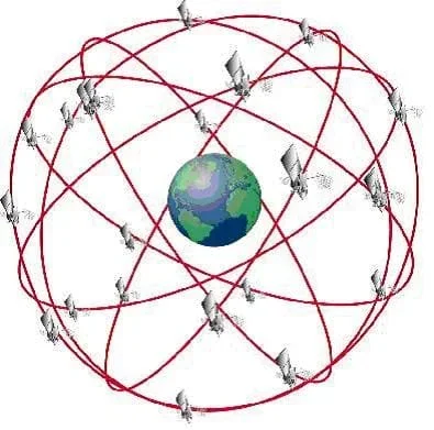 Figure 1. GPS satellite ranging.Copyright http://www.fra.dot.gov/rdv30/ndgps/ndgps_how.htm
GPS satellite ranging allows a receiver to calculate its current 3-dimensional position — latitude, longitude, and height. Because the ranging measurements are based on timing, the times in the satellite transmitter and the user's receiver have to be coordinated. A GPS receiver measures the range to 4 satellites to determine latitude, longitude, height and this timing correction.
Let's take this one step at a time. For now, assume that the satellite and receiver clocks are already coordinated, and the positions of the satellites are known. If we measure distance to one satellite, we know that we are located on a sphere of that radius, centered on the satellite. With two satellite range measurements, our location is limited to a circle and with three satellites to one of two points. A fourth satellite can be used to find the correct point and to take care of the time coordination. (See Figure 2 for a visual of this explanation.)
If it has extra information, a receiver can figure out its position with fewer satellites. For example, if you know that you are on the ocean surface, you can use this piece of information and only three satellites to find your latitude, longitude, and timing. In this case, height is not needed because you already know it, sea level.
So, how do we know where the satellites are? All satellites are constantly monitored. They have a 12-hour orbit, and the U.S. Department of Defense is able to monitor the satellites from ground stations around the world. The satellites are checked for errors in their position, height, and speed. These minor errors are caused by gravitational pulls from the moon, sun, and even pressure from solar radiation on the satellite. The satellites transmit special codes for timing purposes, and these codes carry a data message about their exact location. This helps to locate the satellite precisely.
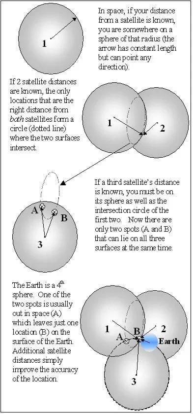 Figure 2. How GPS works.Copyright J. White and M. Lippis, University of Colorado at Boulder, 2003.
Before the Activity
- Print out a GPS Worksheet (double sided) and a GPS States Map for each student.
- Make measurements and record data for any additional states or locations desired.
With the Students
- Start with a discussion. Ask students: Is it smart to go on a hike with only a GPS unit to guide you? (Answer: No, GPS should never be the only navigation tool used.) What would you do if your GPS unit malfunctioned or stopped working? (Answer: You should always have a paper map and a compass to rely on. Also, you should be familiar with using the sun, moon, and stars as a basic guide to direction.)
- Hand out the string and paper clips to each group. Have them tie one end of the string to the paper clip.
- Give each student a GPS Worksheet and have them read the introduction and arc instructions.
- Hand out a GPS States Map to each group and have the students follow the instructions on the worksheet and answer the questions. Each student should fill in answers on their own worksheet.
- When a group finishes, direct them to find some of the "friends" on the back of the worksheet (if time permits).
- At the end, run numbered heads assessment together as directed in the Assessment / Evaluation section.
Pre-Activity Assessment
Discussion Questions: Solicit, integrate and summarize student responses.
- Is it smart to go on a hike with only a GPS unit to guide you? (Answer: No, GPS should never be the only navigation tool used.) What would you do if your GPS unit malfunctioned or stopped working? (Answer: You should always have a paper map and a compass to rely on. Also, you should be familiar with using the sun, moon, and stars as a basic guide to direction.)
Activity Embedded Assessment
Worksheet Questions: Have the students complete the activity worksheet; review their answers to gauge their mastery of the subject.
Post-Activity Assessment
Numbered Heads Together: Have the students on each team pick numbers (or number off) so each member has a different number. Ask the students a question (give them a time frame for solving it, if desired). The members of each team should work together on the question. Everyone on the team must know the answer. Call a number at random. Students with that number should raise their hands to answer the question. If not all the students with that number raise their hands, allow the teams to work a little longer. Ask the students:
- How many distances do you need to triangulate a position on a map? (Answer: 3).
- What does GPS stand for? (Answer: Global Positioning System)
- If you know you are 1 Earth radius away from the center of the Earth, where are you? (Answer: Anywhere on the surface of the Earth.)
- If you know you are 4 Earth radii away from the center of the Earth, where are you? (Answer: In space, possibly riding a GPS satellite.)
- Would you rather have 3 or 4 satellites locked when using GPS and why? (Answer: Four because the more satellites engaged gives you a more accurate position.)
Sometimes it is hard for students to get the precise answer every time. Explain to them that there will be differences in answers due to which end of the paper clip they measure from and how taut they pull the string. Accept any answers that are in a reasonable range.
On the Intenet, have students go to http://www.nr6ca.org/gpsexplained.html and research how GPS uses trilateration.
- For 6th and 7th grade, do activity as is.
- For 8th grade, adjust the "Where Are They?" table and add a random +/- .5 cm to each number in the data. Edit before printing or do not print the page double sided and write the table with adjusted numbers on the board.
GPS States Map courtesy of The General Libraries, The University of Texas at Austin.
- Plot Your Course - Navigation
- Where Is Here?
- How to be a Great Navigator!
- Navigating by the Numbers
- Accuracy, Precision and Errors in Navigation: Getting It Right!
- Topo Map Mania!
- Getting to the Point
- Navigational Techniques by Land, Sea, Air and Space
- Navigating at the Speed of Satellites
- State Your Position
- It's About Time
- GPS on the Move
- Not So Lost in Space
Contributors
Jeff White; Matt Lippis; Penny Axelrad; Janet Yowell; Malinda Schaefer Zarske
Supporting Program
Integrated Teaching and Learning Program, College of Engineering, University of Colorado Boulder
Acknowledgements
The contents of this digital library curriculum were developed under a grant from the Satellite Division of the Institute of Navigation (www.ion.org) and National Science Foundation GK-12 grant no. 0338326.
Copyright
2004 by Regents of the University of Colorado.