
Making GPS Art: Draw It, Walk It, Log It, Display It!
Students design their own logos, pictures or other graphic images and then use handheld GPS receivers to map them out. They write out the image on a field or playground, walk the route, and log GPS data. Displaying the collected data on the GPS receiver screen results in the finished artwork. The process requires students to use geometry, sketch, measure distances and make scaling calculations, and familiarizes them with technological devices. A student worksheet is provided.
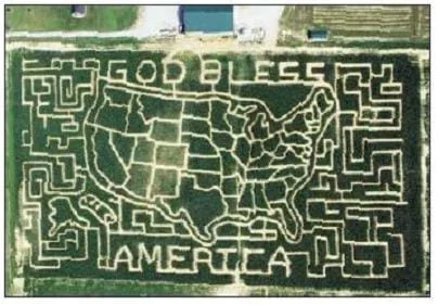 Figure 1. GPS art made in a corn field.Copyright Institute of Navigation Newsletter, Vol. 12, No. 4 (winter 2002-3) Used with permission. http://ion.org/newsletter/
Engineers design GPS technology for many applications. In industry, GPS has uses in agriculture, surveying, map making from aerial photographs, public safety and telecommunications. GPS is used in recreation, sports and transportation on land, water, air and space. Science provides a wide range of applications: archaeology, atmospheric science, environmental, geology, oceanography and wildlife. In some cases, tiny transponders and transmitters are applied to birds, animals, products, shipments and measurement devices to collect data such as location, movement, altitude/depth and speed.
After this activity, students should be able to:
- Use geometry and scaling in order to draw a sketch.
- Use numbers to count, measure, label, and indicate distances and points on a GPS receiver.
- Measure and calculate values from acquired data.
- Understand how technology is needed to explore space.
- 7.4.1.a.i Solve problems involving scale drawings of geometric figures, including computing actual lengths and areas from a scale drawing and reproducing a scale drawing at a different scale.
Grade 7
Do you agree with this alignment?
- Describe methods and equipment used to explore the solar system and beyond
Grade 8
Do you agree with this alignment?
- CCSS.Math.Content.7.G.A.1 Solve problems involving scale drawings of geometric figures, including computing actual lengths and areas from a scale drawing and reproducing a scale drawing at a different scale.
Grade 7
Do you agree with this alignment? - CCSS.Math.Content.HSG-CO.D.12 Make formal geometric constructions with a variety of tools and methods (compass and straightedge, string, reflective devices, paper folding, dynamic geometric software, etc.). Copying a segment; copying an angle; bisecting a segment; bisecting an angle; constructing perpendicular lines, including the perpendicular bisector of a line segment; and constructing a line parallel to a given line through a point not on the line.
Grades 9-12
Do you agree with this alignment?
- Information and communication systems allow information to be transferred from human to human, human to machine, and machine to human.
Grades 6-8
Do you agree with this alignment?
Each group needs:
- GPS receiver
- GPS Art Worksheet (PDF), one per student
The global positioning system (GPS)—a satellite-based radio navigation system owned by the U.S. government and operated by the U.S. Airforce—has some very serious uses, such as for ship navigation at sea, airplane landing systems, and search and rescue operations.
However, GPS can also be used for fun activities and recreational purposes. For example, have you ever played in a maze that has been cut into a corn field? Did you wonder how that corn maze was created? Well, today farmers and recreational clubs can use GPS to design and plow mazes into fields.
(Show students Figure 1, an aerial photograph of a real corn maze.)
Take a look at this photograph of a real corn maze in a corn field. It was designed using GPS technology and inexpensive software. To design the maze, a GPS engineer made an image of the desired picture using mapping software to produce a set of coordinates that would connect to form a picture—kind of like connecting the dots.
Then these coordinates were downloaded into driving instructions on the farmer's tractor-mounted GPS receiver. The farmer plowed the maze—that is, connected the dots—following the GPS instructions. Amazing!
In today's activity, you will learn how to create your own GPS art and have fun while learning more about the global positioning system.
Background
The global positioning system is a constellation (or set) of at 32 satellites that continuously transmit faint radio signals toward the earth. These signals carry information about the satellite location and special codes that permit anyone with a GPS receiver to measure the distance to the satellite. Combining the distances and satellite locations, the receiver is able to determine its latitude, longitude and height. GPS satellite signals are free and available for anyone to use. GPS technology is increasing in popularity for navigation (cars, buses, cell phones), sporting goods, and many other creative applications and products.
GPS receivers have a permanent memory that remembers their positions from when they were last turned on, and when (time), as well as an almanac of the satellite locations (actually, orbits). If a receiver was used relatively recently in a location not too far away, this information is valid. So, when the receiver is turned on, it begins looking for the satellites that it expects to be visible at the current time at your location. Once it acquires four satellites, it begins showing the current location and current time. At this point, it indicates that it is in 3D navigation mode. The time it takes to get to 3D navigation mode is typically less than a minute, but may take a bit longer, especially if you are not in an open area.
When the receiver is first turned on, it displays some type of satellite visibility page. The satellite page shows the satellites that the receiver thinks are currently visible from your location. The GPS constellation of satellites has a total of at 31 or 32 satellites; sometimes operating at the same time. This means that from any point on earth, at least four satellites are available in the sky above you at all times. The GPS satellites travel in orbits around the earth, each with a period of 11 hours and 58 minutes. So, depending on the time of day you are outside, your receiver sees different satellites above. The same satellites appear each day but their patterns in the sky shift to four minutes earlier each day. When a new satellite is launched or an old satellite is turned off, the receiver is notified as soon as it tracks one of the other satellites in the constellation.
Each GPS satellite has a unique number that identifies it, sometimes called a PRN (pseudo random noise code number). The satellite number is shown on the bullseye plot (a bullseye-looking diagram in the center of the receiver's screen) and on the bottom of the screen. The bullseye represents the sky above you. Satellites shown in the center are directly overhead, and satellites shown near the outermost ring are near the horizon. North is typically at the top of the screen.
Before the Activity
- Gather materials and make copies of the GPS Art Worksheet (PDF), one per student.
- Set up all the GPS receivers to the default or common settings. Steps to do this:
- Clear the current track.
- Set the units to the factory default or to another common setting that you prefer.
- Set the time on all receivers to show either local time or UTC time (Greenwich).
- Find—and arrange to use—an outdoor area in which to conduct the activity, such as an open field or playground.
With the Students
- Start a class discussion by asking a few questions: What do you think is the largest size letters that a person could write their name? Such as in the sand or in a corn field. Make an estimate. And, how would they do it? What objects would they use?
- Hand out the worksheet. To tie into geometry concepts, assign students different types of triangles—acute, right or obtuse—to trace with their GPS receivers in the space indicated on the worksheet. Advise them to keep it simple; straight lines are much easier to follow than curves.
- Direct students to orient their papers in the direction of the outdoor area where the activity will be conducted. Have them determine the heading or direction of each line segment in their picture.
- Have students pick a scale to map their pictures to a distance they will walk in the field. Think about how big it has to be for the handheld GPS to be accurate enough to use. They may need to try a few different line lengths to determine what works best.
- Direct students to start at the beginning of their pictures and mark the starting waypoints.
- Suggest that they head in the direction indicated by their pictures for the distance they want. Then enter additional waypoints at each turn, mapping out the picture.
- Tell the students are done, they should be able to see their picture on the receiver's map display. Have them critique their pictures. How does it look? How well do the edges and corners meet?
- Direct students to put their waypoints together in a route and try to retrace their pictures. Did it work?
- To conclude the activity, conduct the post-activity voting assessment as described in the Assessment section.
Pre-Activity Assessment
Estimates: Ask students to make estimates:
- What is the largest size letters that a person could write his/her name, such as in the sand or in a corn field?
- How would they do it? What objects would they use?
Activity Embedded Assessment
Worksheet: Have students complete the GPS Art Worksheet (PDF). Review their answers to gauge their mastery of the subject.
Post-Activity Assessment
Problem Solving: Have students engage in open discussion to suggest solutions to questions/problems. For example:
- What scale did you use to map your picture? Was the scale large or small? Why?
Request that students be very careful with the GPS receivers so as not to cause any damage—especially if they are borrowed!
Make sure students stay in their groups and do not to stray too far from the classroom—they are still novice GPS users!
Have spare batteries available since the receivers may use them up quickly.
To begin, have students draw simple letters, such as "H" and "E."
Have students use the GOTO function to get back to an intersection.
For best results, advise students to make their pictures large. If too small, GPS errors will be more noticeable and the resulting pictures might not be legible.
It is important that students do NOT lift up their pencils or pens while drawing their pictures since GPS receivers continuously track the image path, so the path cannot be broken in their pictures. Expect students to learn this soon enough by trial and error.
- Plot Your Course - Navigation
- Where Is Here?
- How to be a Great Navigator!
- Navigating by the Numbers
- Accuracy, Precision and Errors in Navigation: Getting It Right!
- Topo Map Mania!
- Getting to the Point
- Navigational Techniques by Land, Sea, Air and Space
- Navigating at the Speed of Satellites
- GPS on the Move
- GPS Receiver Basics
- Making GPS Art: Draw It, Walk It, Log It, Display It!
- GPS Scavenger Hunt
- Not So Lost in Space
Contributors
Matt Lundberg; Penny Axelrad; Janet Yowell; Malinda Schaefer Zarske
Supporting Program
Integrated Teaching and Learning Program, College of Engineering, University of Colorado Boulder
Acknowledgements
The contents of this digital library curriculum were developed under a grant from the Satellite Division of the Institute of Navigation (www.ion.org) and National Science Foundation GK-12 grant no. 0338326.
Copyright
2004 by Regents of the University of Colorado