Quick Look
Grade Level: 5 (3-5)
Time Required: 15 minutes
Lesson Dependency: None
Subject Areas: Earth and Space
Summary
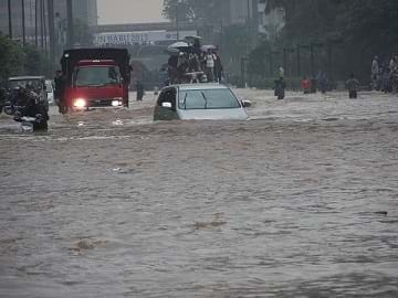
Students learn about floods, discovering that different types of floods occur from different water sources, but primarily from heavy rainfall. While floods occur naturally and have benefits such as creating fertile farmland, with the increase in human population in flood-prone areas, floods are become increasingly problematic. Both natural and human-made factors contribute to floods. Students learn what makes floods dangerous and what engineers design to predict, control and survive floods.Engineering Connection
Floods can be as deadly and destructive to people and property. Engineers work with geologists and meteorologists to devise ways to control flooding with a range of human-made structures: dams, dikes, levees, flood gates, seawalls, drainage canals, sewer/water/storm drainage systems, pumping stations, bridges, concrete river banks, spillways, overflow basins, embankments, retention ponds and wetlands restoration. To aid in prediction and planning, engineers and scientists also develop instruments and computer programs to monitor weather (precipitation, temperature, snow pack, etc.), and develop complex models to estimate worst-case-scenario storm surges and flood risks.
Learning Objectives
After this lesson, students should be able to:
- Define flooding as involving heavy rainfall or snowmelt.
- List three types of flooding.
- Identify reasons why humans tend to settle in floodplains.
- Explain that engineers design dams, dikes and levees to control flooding.
Educational Standards
Each TeachEngineering lesson or activity is correlated to one or more K-12 science,
technology, engineering or math (STEM) educational standards.
All 100,000+ K-12 STEM standards covered in TeachEngineering are collected, maintained and packaged by the Achievement Standards Network (ASN),
a project of D2L (www.achievementstandards.org).
In the ASN, standards are hierarchically structured: first by source; e.g., by state; within source by type; e.g., science or mathematics;
within type by subtype, then by grade, etc.
Each TeachEngineering lesson or activity is correlated to one or more K-12 science, technology, engineering or math (STEM) educational standards.
All 100,000+ K-12 STEM standards covered in TeachEngineering are collected, maintained and packaged by the Achievement Standards Network (ASN), a project of D2L (www.achievementstandards.org).
In the ASN, standards are hierarchically structured: first by source; e.g., by state; within source by type; e.g., science or mathematics; within type by subtype, then by grade, etc.
NGSS: Next Generation Science Standards - Science
-
DCI.ESS2.C.3-5.2.
Nearly all of Earth's available water is in the ocean. Most fresh water is in glaciers or underground; only a tiny fraction is in streams, lakes, wetlands, and the atmosphere.
(Grade 5)
More Details
Do you agree with this alignment?
-
DCI.ESS3.B.3-5.3.
A variety of hazards result from natural processes (e.g., earthquakes, tsunamis, volcanic eruptions). Humans cannot eliminate the hazards but can take steps to reduce their impacts.
(Grade 4)
More Details
Do you agree with this alignment?
International Technology and Engineering Educators Association - Technology
-
Structures need to be maintained.
(Grades
3 -
5)
More Details
Do you agree with this alignment?
-
Explain how various relationships can exist between technology and engineering and other content areas.
(Grades
3 -
5)
More Details
Do you agree with this alignment?
State Standards
Colorado - Science
-
Earth's surface changes constantly through a variety of processes and forces
(Grade
5)
More Details
Do you agree with this alignment?
Worksheets and Attachments
Visit [www.teachengineering.org/lessons/view/cub_natdis_lesson07] to print or download.Pre-Req Knowledge
A basic understanding of gravity and familiarity with geography. An understanding of the water (hydrological) cycle is helpful.
Introduction/Motivation
Who has ever stepped outside after a heavy rain and played in the water running down the street or in the puddles? It's a lot of fun. Where does that water go? (Possible answers: It is absorbed into the ground, flows down drains into streams and rivers, or it evaporates.) So, why do puddles form sometimes and not form other times? Well, sometimes there is so much rain falling so quickly that the ground cannot absorb it all. And, to add to the problem, people often cover over or remove soil (with concrete or asphalt) that would usually be there to absorb water. This is when water starts to become a problem.
Is rain a good thing or a bad thing? Who thinks that rain is good? Who thinks that rain is bad? (Have the students raise their hands in response.) Well, rain is very important — it is our primary source of fresh water. It fills our lakes and rivers. Has anyone ever been to the ocean? Could you drink that water? No, of course not — it is very salty. Do not try it. It will make you sick if you drink too much of it. Have you ever heard the expression, "Water water everywhere, [but not a] drop to drink?" (Source: Samuel Taylor Coleridge, The Ancient Mariner) Most of the water on our planet is saltwater. This means that water from rain and snow runoff is very important to us as a supply of fresh water for drinking. Rain and snow are very important parts of the cycle of water through the earth. (Review the water cycle, as necessary.) It is when we get too much rain or melting snow and ice that water becomes a problem.
(At this point, show students the attached PowerPoint presentation, Floods, Floodplains and Levees, to provide a visual understanding of floods, floodplains and levees. Or, print out some of the images to pass around class during the introductory discussion.)
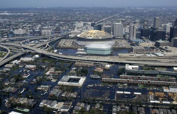
Too much rainfall or melting snow can sometimes cause a flood. There are different types of floods. The most common type is generally called a river flood. It occurs when a river or similar body of water (stream, creek, brook, etc.) overflows because of heavy rainfall and sometimes because of melting snow and ice. Other times, heavy rains are the result of hurricanes or other large storms. Many streams and rivers that have been flooding for thousands of years (or longer) become a problem when people start building in areas where the flooding happens.
Unfortunately, floodplains, or the areas around rivers where flooding tends to occur, are pretty nice places to build towns and cities. Why do you think people want to build a town or city near a river, on a floodplain? Well, these plains are generally flat, are near the river for transportation and recreation, and the land is good for growing crops because of the rich soil deposited by past floods.
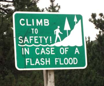
Who has ever heard of a flash flood? Flash floods occur over a very short periods of time, and are usually caused by heavy rains. They can also be caused by ice jams on rivers, or when a dam breaks (natural and human-made). Does anyone know what to do in case of a flash flood? Run? No, you cannot outrun a flash flood. The answer is: Climb to higher ground IMMEDIATELY! Did you know it only takes 15 cm (6 inches) of fast moving water to knock you down and wash you away? Less than .6 meter (2 feet) of fast moving water can wash away a car, or even a big SUV or truck. More than half the people who are killed in flash floods are trying to drive through fast moving floodwaters in their vehicles.
Coastal flooding is another type of flooding that occurs when strong onshore winds from storms push water onto the land. This is the type of flooding that you see along the seashore during a hurricane or tropical storm. It usually happens in combination with flooding from heavy rains.
When flooding is really heavy or not predicted, it becomes dangerous and destructive. The many floods throughout history have affected a lot of people. Some engineers study flooding, and use what they learn to protect people and property. These engineers design things to control flooding such as dams, dikes and levees that help keep fast moving and dangerous flood waters away from people's homes and roads. Engineers also work with scientists to develop instruments and computer programs to monitor the rain and snow weather patterns to better predict when and where floods might occur.
Lesson Background and Concepts for Teachers
A flood can be defined simply as too much water in the wrong place. This applies to situations ranging from a flooded basement to huge tracts of the Mississippi basin. But how does water wind up in these places, potentially causing so much destruction and death?
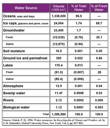
Water is everywhere on our planet. It is the only known substance that can exist as a gas, liquid and solid within the relatively small range of air temperatures and pressure found at the earth's surface. It is the basis of life as we know it. The human body is more than 98% water. The earth's water content is approximately 331 million cubic miles (1,380 cubic km), with 96.5% of that found in oceans, seas and bays. Approximately 1.7% is found in the polar ice caps, 1.7% is is stored in groundwater, lakes, rivers, streams and in soil, and only a thousandth of 1% exists as water vapor in the atmosphere. See an estimate of the earth's water distribution in Table 1, according to NASA's Earth Observatory Online Magazine.
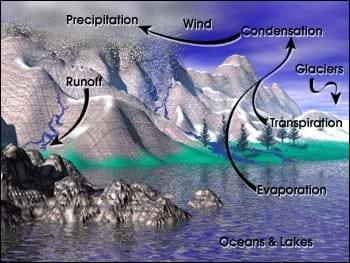
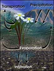
Flood water comes primarily from rain as the result of a process called the hydrological cycle (see Figure 1). Ninety percent of the water that enters the atmosphere is evaporated from oceans, rivers and lakes by heat from the sun. A much smaller fraction enters the atmosphere via sublimation (solid water such as snow or ice being converted directly to water vapor). Approximately 10% is released into the atmosphere by plants via a process called transpiration (see Figure 2). As an example of how much transpiration can affect the hydrological cycle, a one-acre (.4 sq hectometer) cornfield can transpire as much as 4,000 gallons (15,142 liters) of water every day. When people strip the land of vegetation, a considerable component of water removal is lost. Farming, deforestation and urbanization increase water runoff from rains.
When water falls as precipitation (rain, snow, sleet, hail), some evaporates back into the atmosphere, some seeps into the ground as soil moisture and groundwater, and the rest flows into rivers and streams, eventually finding its ways into oceans or other large bodies of water. When the ground becomes saturated and/or cannot accommodate the runoff, river levels rise. Overflowing rivers naturally spill over their banks into adjacent floodplains. Humans try to prevent this from happening by building levees and dams. Students can invesigate how a river behaves with different terrain and amounts of water, and at what point flooding occurs with the associated activity Floodplain Modeling.
Famous U.S. Floods
Since 1900, floods have caused more than 10,000 lives in the U.S. alone.
Johnstown Flood, Pennsylvania, 1889: One of the largest disasters in U.S. history resulting from a human-made dam. The earthen dam creating a three-mile (five-km) long, one-mile (1.6-km) wide, 65-foot (20-m) deep lake failed after eight inches (20 cm) of rain fell, releasing 20 million tons (18 million metric tons) of water downstream toward the city of Johnstown. More than 2,200 people lost their lives as a result, and possibly many more who were unreported.
Big Thompson Canyon Flood, Colorado, 1976: A flash flood killed 140 people, most who tried to outrun the flood instead of climbing to higher ground.
Mississippi River Flood, 1927: Raging waters tore through levees in Arkansas, Mississippi and Louisiana, killing at least 1,000 people and inundating one million homes. In response, Congress funded programs for engineers to straighten the river in places, add floodgates in others and increase the height of its levees from Vicksburg, Mississippi, to the Gulf of Mexico.
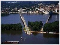
Mississippi River Flood, 1993: This flood covered an area 500 miles (805 km) long and 200 miles (322 km) wide. More than 50,000 homes were damaged, and 12,000 miles (19,312 km) of farmland were washed out (see Figure 3).
New Orleans Hurricane Katrina Flood, 2005: Category 5 Hurricane Katrina caused levee breaks and a mammoth flood in a highly-populated area. The storm surges flooded 80% of the city; some parts of the city were under 20 feet (6 m) of water. After a disastrous evacuation of ~300,000 residents, and at least 1,600 fatalities, many thousands were left displaced (some permanently, in below sea-level areas) due to the pervasive destruction of homes, buildings and urban infrastructure. This was the deadliest U.S. hurricane since 1928, and the costliest in U.S. history ($75 billion in damages).
Flood Facts
Most people are unaware that:
- 80% of flood deaths occur in vehicles, and most happen when drivers make a single, fatal mistake trying to navigate through floodwaters.
- Just six inches (15 cm) of rapidly moving floodwater can knock a person down.
- A mere two feet (.6 m) of water can float a large vehicle, even a bus.
- One-third of flooded roads and bridges are so damaged by water that any vehicle trying to cross stands only a 50% chance of making it to the other side.
Flash Floods
Flash floods can occur anywhere, in mountainous or flat terrain. They are often caused by heavy rainfall of short duration in a fairly localized area. It is their sudden and unpredictable nature that makes flash floods so dangerous. Flash floods are common in the Rocky Mountains and the desert areas of the American west and southwest, areas with low average rainfall.
Typical mountain weather patterns generate sudden thunderstorms on sunny days, creating tremendous runoff in regions in which the ground is poorly equipped to absorb water. Rain is channeled into gullies and ravines, quickly turning quiet streams into rampaging torrents. Walls of water and sediment travel down river valleys, raising the river level several feet in a few seconds. The resulting flooding can extend downstream well beyond the area of the storm itself.
Flood Destruction
Floods can be far more dangerous than just washing away soil and saturating everything with water and silt. Floods can destroy drainage and sewage systems in urban areas, causing raw sewage to be released into waterways. Severe floods can actually destroy buildings and other facilities, releasing all kinds of toxic materials into the water including oil and gasoline, pesticides and other chemicals. Chemicals make their way through the water cycle into rivers, lakes and oceans. People are left without sanitation systems, drinking water, electricity, phone lines, homes and work places. The costs of floods can be in the billions of dollars and completely change life in some areas.
In non-urbanized areas, flooding regenerates the natural environment, creating beautiful meadows, wetlands and riparian zones. In natural areas, floods spread nutrient-rich top soil and remove silt and plant debris from floodplains. The preservation of natural floodplains can accommodate flood waters and reduce flood damages.
Associated Activities
- Floodplain Modeling - Using a table top-sized model made of clay and baking pans, students investigate how a river behaves with different terrain and amounts of water, and at what point flooding occurs. They modify the riverbed with levees to simulate real-world scenarios.
Lesson Closure
Today we learned a little about floods. What can cause a flood? (Possible answers: Rain, heavy snow melt, hurricanes, etc.) What are three types of floods we heard about? (Answer: River floods, flash floods and coastal floods.) We also learned that many things affect whether or not a flood will occur. Engineers study how floods occur, and then they design and build structures to prevent property from being damaged by floods. Can anyone name something that engineers build to prevent flooding of property? (Possible answers: Levees, dams, dikes, canals, sewer and storm drains, etc). Engineers also design weather equipment and computer models to help us predict floods.
Here is something for everyone to think about: We said that floods are something that happens naturally. When flood waters overflow, they are absorbed by the land and evaporate. If your town is built on a floodplain and you build structures like a levee that prevents your town from flooding, what does that do to the towns downstream from you? Will they be more or less likely to flood because of your town's levees? You can see that this is a very complicated problem for everyone, including engineers, and as there are more and more people and development, floods continue to cause damage every year.
Despite the best efforts of engineers throughout the centuries, and even in modern times, floods continue to affect millions of people. Dams and levees can fail and let water through. Property can be damaged and people can get injured. It may be impossible to control all flooding, but through the continued effort of engineers, we can figure out ways to live with flooding so that this damage and injury can be reduced.
Vocabulary/Definitions
dam: A large structure that retains flowing water into a reservoir to control flow.
dike: Another term for levee.
evaporate: The conversion of water from liquid to gas form due to heating.
flood: Too much water at in a given place at a given time. Types: river flood, coastal flood and flash flood.
floodplain: Normally dry land surrounding a waterway into which flood waters spill.
hydrological cycle: The Earth's planetary cycle of fresh water evaporating from bodies of water, falling as precipitation, being absorbed into ground or flowing down into streams, rivers, etc., back into large bodies of water. Also called the water cycle. See Figure 1.
levee: A human-made barrier constructed to contain the flow of water or to keep out the sea.
Assessment
Pre-Lesson Assessment
Know / Want to Know / Learn (KWL) Chart: Before the lesson, ask students to write down in the top left corner of a piece of paper (use the attached KWL Chart on Flooding, or, as a group, use the classroom board) under the title, Know, all the things they know about flooding. Next, in the top right corner under the title, Want to Know, ask students to write down anything they want to know about flooding. After the lesson, ask students to list in the bottom half of the page under the title, Learned, all of the things that they have learned about flooding. Discuss as a class.
Post-Introduction Assessment
Question/Answer: Ask students the following questions and have them raise their hands to respond. Write their answers on the board.
- What is a flood? (Answer: Too much water caused by rainfall or melting snow.)
- What are three types of floods? (Answer: River floods, flash floods and coastal floods.)
- What is a floodplain? (Answer: The area around rivers where flooding tends to occur.)
- Why do people sometimes build cities or towns near a river in a floodplain? (Answer: People build near rivers because it is pretty; the river can be used for transportation and recreation; and the land is good for growing crops.)
- Why do engineers care about flooding? (Answer: Engineers protect people and property from flooding by designing things to control flooding such as dams, dikes and levees, as well as weather instruments used to predict flooding.)
Lesson Summary Assessment
KWL Chart (continued): Finish the remaining section of the KWL Chart as described in the Pre-Lesson Assessment section (use the attached KWL Chart on Flooding). After the lesson, ask students to list in the bottom half of the page under the title, Learned, all of the things that they have learned about electricity. Discuss as a class.
Safety Engineer: Have students use what they learned about the types of floods to create a safety poster, drawing or flyer for a town that is located on a floodplain. What would they say to help the people of the town understand more about flood danger and what the citizens can do to help protect their town from a flood.
Lesson Extension Activities
Have students investigate the floods caused by Hurricane Katrina in New Orleans to find out how natural disasters like hurricanes can be directly related to flooding and the failure of engineering structures such as levees.
Additional Multimedia Support
Floods, Floodplains and Levees (a PowerPoint® file)
Subscribe
Get the inside scoop on all things Teach Engineering such as new site features, curriculum updates, video releases, and more by signing up for our newsletter!More Curriculum Like This

Students are introduced to natural disasters and learn the difference between natural hazards and natural disasters.

Students explore the impact of changing river volumes and different floodplain terrain in experimental trials with table top-sized riverbed models. The models are made using modeling clay in aluminum baking pans placed on a slight incline.

Student are introduced to rivers, and to the components of the water cycle. They think about the effects of communities, sidewalks and roads on the natural flow of rainwater. Students also learn about the role of engineering in community planning and protecting our natural resources.

Students learn about the water cycle and its key components. They learn how we can use the theory of conservation of mass to estimate the amount of water that enters a watershed (precipitation, groundwater flowing in) and exits a watershed (evaporation, runoff, groundwater out).
References
Brouwer, Greg. The Creeping Storm. June 2003. Civil Engineering Magazine. Accessed April 5, 2006. (Source of some teacher background information; good description of New Orleans' pre-Katrina flooding preparedness) http://cedb.asce.org/cgi/WWWdisplay.cgi?0303075
Facts about Flooding. 1995-2006. The Weather Channel Interactive, Inc. Accessed April 5, 2006. (Source of flood facts) http://www.weather.com/safeside/flood/facts.html
Flash Floods and Floods – The Awesome Power! Last updated March 29, 2006. National Oceanic & Atmospheric Administration, U.S. Department of Commerce. Accessed April 5, 2006. http://www.noaa.gov/floods.html
Flood Photos. FEMA for Kids, Federal Emergency Management Agency. Accessed April 5, 2006. (Great selection of flood photos and captions for kids) http://www.fema.gov/kids/p_fld.htm
Graham, Steve, Claire Parkinson and Mous Chahine. The Water Cycle. NASA Earth Observatory. Accessed April 5, 2006. (Source of Table 1) http://geography.about.com/gi/dynamic/offsite.htm?site=http%3A%2F%2Fearthobservatory.nasa.gov%2FLibrary%2FWater%2F
Historical Floods and Flash Floods. 1995-2005. The Weather Channel Interactive, Inc. Accessed March 24, 2006. http://www.weather.com/encyclopedia/flood/history.html
Hurricane Katrina. Last updated April 5, 2006. Wikipedia, The Free Encyclopedia. Accessed April 5, 2006. http://en.wikipedia.org/wiki/Hurricane_Katrina
Perez, Eddie and Paul Thompson. Natural Hazards: Causes and Effects, Lesson 6: Floods. Updated April 1995. Disaster Management Center, College of Engineering, University of Wisconsin-Madison. Accessed April 5, 2006. http://dmc.engr.wisc.edu/courses/hazards/BB02-06.html
Copyright
© 2006 by Regents of the University of ColoradoContributors
Timothy Nicklas; Malinda Schaefer Zarske; Denise W. CarlsonSupporting Program
Integrated Teaching and Learning Program, College of Engineering, University of Colorado BoulderAcknowledgements
The contents of this digital library curriculum were developed under grants from the Fund for the Improvement of Postsecondary Education (FIPSE), U.S. Department of Education and National Science Foundation (GK-12 grant no. 0338326). However, these contents do not necessarily represent the policies of the Department of Education or National Science Foundation, and you should not assume endorsement by the federal government.
Last modified: April 23, 2022


User Comments & Tips