
Plot Your Course - Navigation
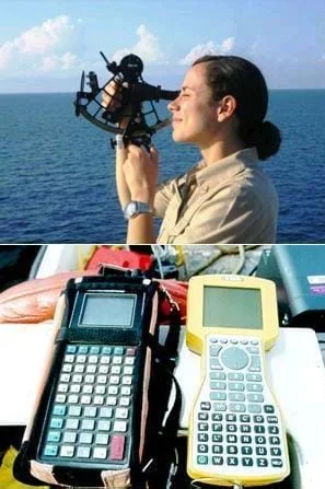 Navigational equipment includes sextants and GPS devices.Copyright NOAA, U.S. Dept. of Commerce http://oceanexplorer.noaa.gov/explorations/07mexico/background/navigation/media/sextant_600.html and U.S. EPA http://www.epa.gov/region5fields/htm/methods/gps/index.html
In this unit, students learn the very basics of navigation, including the different kinds of navigation and their purposes. The concepts of relative and absolute location, latitude, longitude and cardinal directions are explored, as well as the use and principles of maps and a compass. Students discover the history of navigation and learn the importance of math and how it ties into navigational techniques.
Many types of engineering are important to the development of navigational equipment used for travel on sea, in space and on land. Understanding the science of natural phenomena enables engineers to design and create structures and systems for a variety of navigational purposes. Mathematics is also essential to the development of navigational equipment. Satellites designed and tested by engineers use equations that take into account the relative effects of space and time.
Engineering is built upon a network of knowledge extending back in time. Even though celestial navigation is for the most part historical, the best engineers understand how things used to be done, building on the same mathematics concepts—such as geometry and trigonometry—used by engineers every day. Engineers make predictions and analyze circumstances related to motion; they must understand the relationships between speed, time and distance. They use many techniques that often involve computers to help process the many calculations required to make good estimations.
Engineers design systems that require precise and known locations, and often use triangulation calculations. They use triangulation with ground data to determine where in space satellites are located. Accurately determining a satellite's location is important to adjusting its position to keep it on course. The global positioning system (GPS) uses the same concept of triangulation; the development of this now-ubiquitous system was made possible by the contributions from many engineering disciplines. Mechanical engineers created satellite and other GPS equipment that performs reliably in the unique environment of space. Electrical engineers designed computers, circuit boards, power systems and wiring. Aerospace engineers determined satellite arrangement and orbit around the planet. Programming by software engineers enabled the satellites to operate on their own and transmit useful data to Earth receivers.
Engineering is vitally important to the creation of technology used in space, on water and on land. Without engineers, our ability to navigate our world and beyond would be much more difficult. The possibilities for future developments are only limited by our imaginations.
- CCSS.Math.Content.6.NS.B.3 Fluently add, subtract, multiply, and divide multi-digit decimals using the standard algorithm for each operation.
Grade 6
Do you agree with this alignment? - CCSS.Math.Content.7.G.A.1 Solve problems involving scale drawings of geometric figures, including computing actual lengths and areas from a scale drawing and reproducing a scale drawing at a different scale.
Grade 7
Do you agree with this alignment? - CCSS.Math.Content.7.G.A.2 Draw (freehand, with ruler and protractor, and with technology) geometric shapes with given conditions. Focus on constructing triangles from three measures of angles or sides, noticing when the conditions determine a unique triangle, more than one triangle, or no triangle.
Grade 7
Do you agree with this alignment? - CCSS.Math.Content.HSG-CO.D.12 Make formal geometric constructions with a variety of tools and methods (compass and straightedge, string, reflective devices, paper folding, dynamic geometric software, etc.). Copying a segment; copying an angle; bisecting a segment; bisecting an angle; constructing perpendicular lines, including the perpendicular bisector of a line segment; and constructing a line parallel to a given line through a point not on the line.
Grades 9-12
Do you agree with this alignment? - CCSS.Math.Content.HSN-Q.A.1 Use units as a way to understand problems and to guide the solution of multi-step problems; choose and interpret units consistently in formulas; choose and interpret the scale and the origin in graphs and data displays.
Grades 9-12
Do you agree with this alignment?
- MS-ESS1-2 Develop and use a model to describe the role of gravity in the motions within galaxies and the solar system.
Grades 6-8
This resource focuses on the following Three Dimensional Learning aspects of NGSS:
Science & Engineering Practices- Develop and use a model to describe phenomena.Do you agree with this alignment?
Disciplinary Core Ideas- Earth and its solar system are part of the Milky Way galaxy, which is one of many galaxies in the universe.Do you agree with this alignment?
- The solar system consists of the sun and a collection of objects, including planets, their moons, and asteroids that are held in orbit around the sun by its gravitational pull on them.Do you agree with this alignment?
- The solar system appears to have formed from a disk of dust and gas, drawn together by gravity.Do you agree with this alignment?
Crosscutting Concepts- Science assumes that objects and events in natural systems occur in consistent patterns that are understandable through measurement and observation.Do you agree with this alignment?
- Models can be used to represent systems and their interactions.Do you agree with this alignment?
Do you agree with this alignment? - Develop and use a model to describe phenomena.
- MS-PS2-5 Conduct an investigation and evaluate the experimental design to provide evidence that fields exist between objects exerting forces on each other even though the objects are not in contact.
Grades 6-8
This resource focuses on the following Three Dimensional Learning aspects of NGSS:
Science & Engineering Practices- Conduct an investigation and evaluate the experimental design to produce data to serve as the basis for evidence that can meet the goals of the investigation.Do you agree with this alignment?
Disciplinary Core Ideas- Forces that act at a distance (electric, magnetic, and gravitational) can be explained by fields that extend through space and can be mapped by their effect on a test object (a charged object, or a ball, respectively).Do you agree with this alignment?
Crosscutting Concepts- Cause and effect relationships may be used to predict phenomena in natural or designed systems.Do you agree with this alignment?
Do you agree with this alignment? - Conduct an investigation and evaluate the experimental design to produce data to serve as the basis for evidence that can meet the goals of the investigation.
The following schedule provides a suggested order of the lessons and activities. However, you may choose to only teach some of the activities – as your time and priorities permit.
- Where Is Here? lesson
- Nidy-Gridy: Using Grids and Coordinates activity
- Northward Ho! Create and Use Simple Compasses activity
- Find Your Own Direction activity
- How to be a Great Navigator! lesson
- Vector Voyage! activity
- The North (Wall) Star activity
- Navigating by the Numbers lesson
- Stay in Shape activity
- Trig River activity
- Accuracy, Precision and Errors in Navigation: Getting It Right! lesson
- Close Enough? Angles & Accuracy of Measurement in Navigation activity
- Computer Accuracy activity
- Sextant Solutions activity
- Topo Map Mania! lesson
- Where Is Your Teacher? activity
- The Trouble with Topos activity
- Getting to the Point lesson
- Classroom Triangles activity
- Topo Triangulation activity
- Triangulate: Topos, Compasses and Triangles, Oh My! activity
- Navigational Techniques by Land, Sea, Air and Space lesson
- Nautical Navigation activity
- Navigating at the Speed of Satellites lesson
- State Your Position activity
- It's About Time activity
- GPS on the Move lesson
- GPS Receiver Basics activity
- Making GPS Art: Draw It, Walk It, Log It, Display It! activity
- GPS Scavenger Hunt activity
- Not So Lost in Space lesson
- A Roundabout Way to Mars activity
- Plot Your Course - Navigation
Supporting Program
Integrated Teaching and Learning Program, College of Engineering and Applied Science, University of Colorado Boulder
Acknowledgements
The contents of this digital library curriculum were developed under grants from the Satellite Division of the Institute of Navigation (www.ion.org) and the National Science Foundation (GK-12 grant no. 0338326). However, these contents do not necessarily represent the policies of the National Science Foundation and you should not assume endorsement by the federal government..
Copyright
2009 by Regents of the University of Colorado